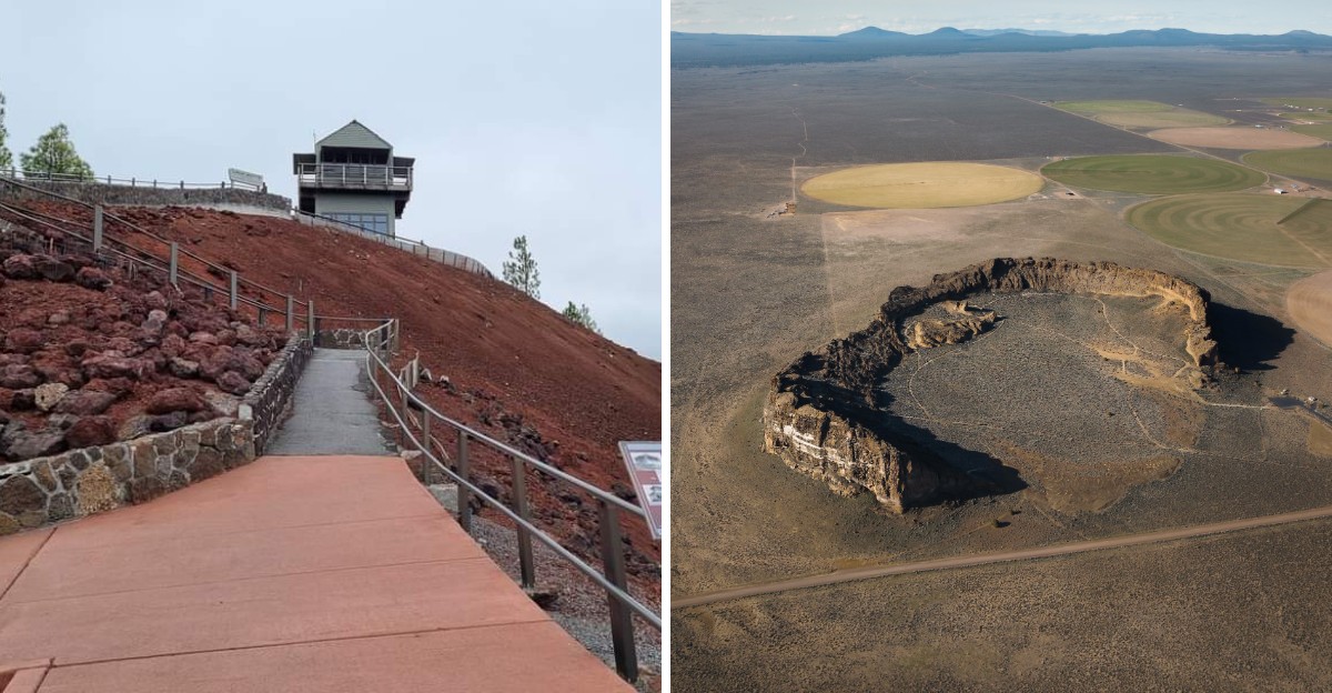
Around 7,700 years ago, a mountain in Oregon blew its top so hard that it collapsed into itself. The hole it left behind now holds the deepest lake in the United States.
I love that a disaster that huge turned into something so calm and blue. And that mountain is far from the only one that left a mark. Across the state, old eruptions built rock towers, cracked the desert floor, and painted hills in stripes.
The best part is that you can walk right up to most of this. You can stand on lava, peek into a cold split in the ground, or climb a stone lookout built from the very rock around it.
I can’t think of a better excuse for a road trip. So which fiery leftover would you want to see first?
1. Crater Lake National Park
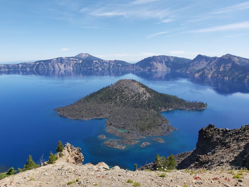
A volcano basically fell in on itself, and the leftovers became one of the most famous views in America. Crater Lake sits inside a caldera left by ancient Mount Mazama after it collapsed.
The park covers 183,224 acres in southern Oregon. Its centerpiece is the deepest lake in the United States, cradled in a crater about 6 miles wide.
That size is hard to picture until you see the rim for yourself. Then the deep blue water makes the whole scene look almost unreal.
The park also holds a historic lodge, which adds a classic touch to the wild scenery. Think of it as old-school charm perched on the edge of a giant volcanic bowl.
Want a side trip that shows off strange geology? The Pinnacles Trail is a popular pick for views and unusual rock formations.
Kids are welcome here, and the park offers hikes that work well for younger legs. Picnic tables and public restrooms make a long day much easier to handle.
Bringing your dog? Dogs are allowed in the park, though you’ll want to check rules for specific trails before you go.
The park is listed as open 24 hours, which makes sunset and stargazing trips tempting. Weekend afternoons tend to be the busiest, so an early start can pay off.
Here’s a fun thought to carry along the rim. The calm lake you’re admiring exists because of one of the biggest blasts in the region’s history.
Not bad for a mountain that technically isn’t there anymore.
Address: Crater Lake National Park, Klamath County, OR
2. Smith Rock State Park
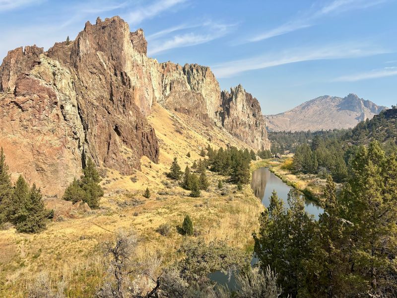
Climbers from far and wide come here to hang off cliffs that started out as volcanic ash. Smith Rock State Park is a famous rock climbing spot in a dramatic river canyon.
The park covers about 650 acres of central Oregon high desert. The Crooked River carved a deep path through it, leaving tall basalt and tuff spires standing guard.
Tuff is rock made from volcanic ash that settled and hardened. Basalt comes from cooled lava, so the canyon is a mix of two fiery ingredients.
Time and water did the sculpting. The result is a landscape of towers and walls that seems built for adventure.
Not into climbing? No problem, since hiking trails wind through the park with big views along the way.
One formation called Monkey Face gets plenty of attention. Spotting it is half the fun, so keep your eyes on the skyline.
Families will appreciate the playground and kid-friendly hikes. Picnic tables, a viewpoint, and public restrooms with flush toilets round out the basics.
Dogs are allowed, so your four-legged hiking buddy can tag along. Parking here is paid, so plan for that before you arrive.
Weekends bring the biggest crowds, especially from morning through afternoon. A weekday visit can feel a lot more relaxed.
The park also has primitive campsites if one day isn’t enough. Waking up beside those spires sounds like a pretty great alarm clock.
Address: 9241 NE Crooked River Dr, Terrebonne, OR 97760
3. Dee Wright Observatory
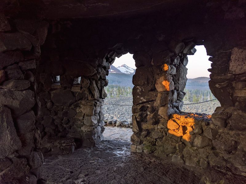
Most lookouts are built from wood or concrete, but this one is made from the lava field it overlooks. Dee Wright Observatory sits on McKenzie Pass, surrounded by black volcanic rock.
The stone shelter rises roughly 30 to 40 feet above the road below. It stands in the middle of a lava field covering around 65 square miles.
That’s a lot of rough, jagged rock. Looking out across it feels a little like visiting another planet.
The real treat is the mountain lineup. From the observatory, you can spot Cascade peaks including Mount Jefferson and two of the Three Sisters.
Openings in the stone walls help frame the views. It’s like a natural window display, except the products are volcanoes.
Here’s a neat bit of history. The observatory was built by the Civilian Conservation Corps in the 1930s and named after crew foreman Dee Wright.
Getting there is part of the adventure, since the site sits along the scenic McKenzie Highway. Free parking is right on site, which makes stopping easy.
The observatory is listed as open 24 hours. Keep in mind the pass highway usually closes in winter because of snow, so summer and early fall are your best bet.
Kids tend to love scrambling around this kind of spot. Just remind everyone that lava rock is sharp and wobbly in places.
Sneakers with good grip are a smart call. Your ankles will thank you later.
Address: McKenzie Hwy, Blue River, OR 97413
4. Diamond Craters Outstanding Natural Area
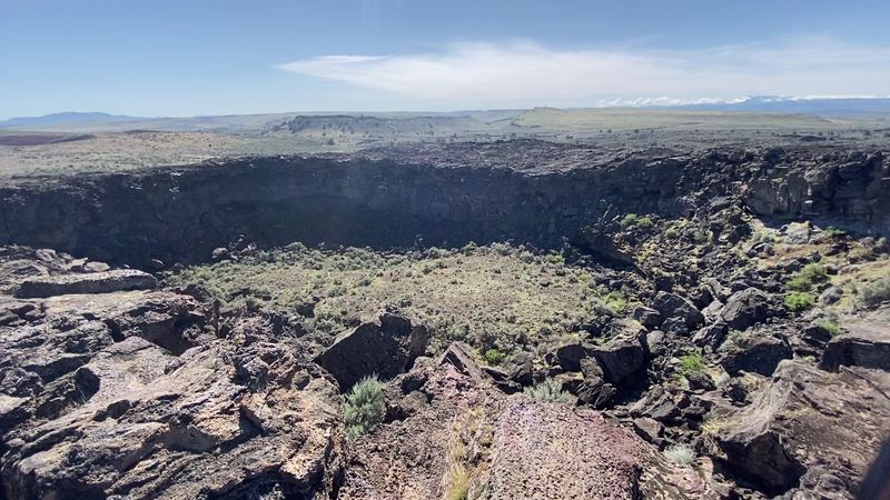
Geologists sometimes call basalt volcanoes predictable, but this spot shows off nearly every trick they can pull. Diamond Craters packs some of the most diverse basaltic features in the nation into one small, reachable area.
The Outstanding Natural Area covers approximately 17,000 acres of remote volcanic terrain. It formed sometime in the past 25,000 years, which is quite young for rocks.
From a distance, the land looks like a thin, rocky pancake with a few bumps. Up close, those bumps turn out to be a museum of volcanic action.
You can find craters, vents, cinder cones, and spatter cones. There are also lava tubes, driblet spires, a graben, and a water-filled maar.
Need a quick guide? A graben is a chunk of land that dropped down between faults, and a maar is a crater formed by a steam explosion.
Driblet spires are the fun ones. They form when blobs of lava pile up into little towers, like a sandcastle made of fire.
This site sits in remote Harney County in southeastern Oregon. Services are slim, so bring plenty of water, food, and a full gas tank.
The area is listed as open 24 hours and is managed by the Bureau of Land Management. It tends to be quiet, which means you might have craters nearly to yourself.
It’s a solid stop for curious kids and adults alike. Few places explain volcanoes this clearly without saying a single word.
Address: Lava Beds Rd, Diamond, OR 97722
5. Newberry National Volcanic Monument
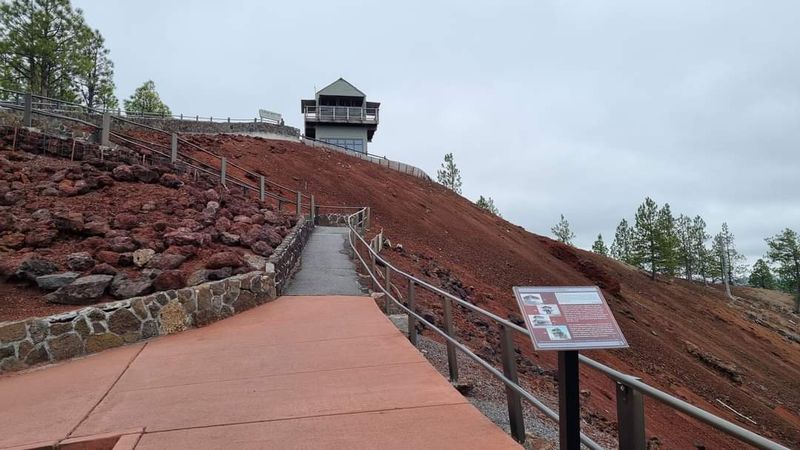
Shiny black glass covering the ground sounds like a movie set, but it’s real near Bend. Newberry National Volcanic Monument packs a caldera, lakes, and an obsidian field into one sprawling area.
Located in the Deschutes National Forest, the monument is basically a volcano sampler platter. You’ll find lava tubes, lava caves, and cinder cones scattered across the landscape.
The obsidian field is a standout. Obsidian is volcanic glass, formed when lava cools so fast that crystals never get a chance to grow.
Lava tubes are just as cool, in a more underground way. They form when the outer crust of a lava flow hardens while hot lava keeps moving inside.
Once the flow drains out, a tunnel stays behind. It’s nature’s version of a subway, minus the trains.
Rangers lead educational programs that explain the volcanic activity, the forest, and the land itself. Interpretive areas help connect the dots if you like knowing why a rock looks the way it does.
On a clear day, you can also catch views of the Cascades from the monument. Those peaks are part of the same fiery story.
Newberry National Volcanic Monument has different operating schedules across its attractions, with visitor centers, Lava River Cave, and some access roads generally open only during warmer months. Tuesdays tend to be quieter, while weekends get busier.
This spot works well for families, and it’s a great classroom without walls. Kids get to touch the science instead of just reading about it.
Bring curiosity and sturdy shoes. Volcanic rock is fascinating, but it isn’t exactly gentle on flimsy soles.
Address: Newberry National Volcanic Monument, Bend, OR 97702
6. Crack in the Ground
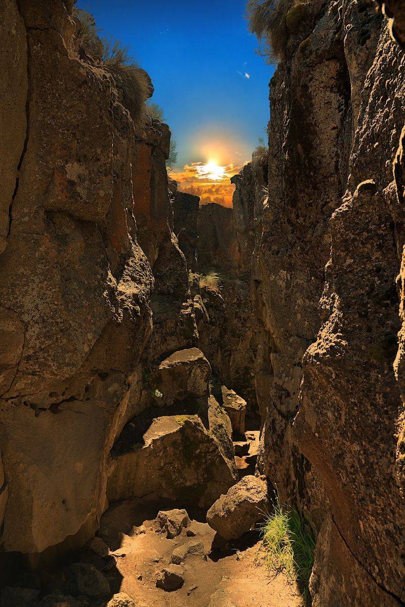
Summer heat in the desert gets a surprise twist once you step down into this giant split in the earth. Crack in the Ground is a long, deep fissure in old basalt near Christmas Valley.
The crack formed along ancient lava flows as the ground shifted and pulled apart. Geologists call it a tension fracture, which is a fancy way of saying the rock got stretched until it broke.
Walking into it feels like entering a sci-fi movie set. Rock walls rise on both sides, and the sky shrinks to a thin strip overhead.
Here’s the best part on a hot day. Temperatures inside the fissure stay noticeably cooler than the ground above.
Getting there takes some patience. The final stretch follows roughly 7 miles of rugged dirt roads that can become impassable, and the Bureau of Land Management strongly recommends a four-wheel-drive vehicle.
Once you arrive, a path leads from the parking area to the fissure. Benches sit in shady spots along the way, which is a welcome touch.
Basic comforts are available too. A restroom is available near Crack in the Ground, but visitors looking for picnic tables can find them at the nearby Green Mountain Campground.
Bring plenty of water, since this part of Lake County is hot and dry. Good shoes help as well, because the floor of the crack can be rocky and uneven.
This Bureau of Land Management site is a reminder that volcanic stories aren’t only about eruptions. Sometimes the ground just cracks, and you get a natural hallway to explore.
Address: Crack in the Ground, Christmas Valley, OR 97638
7. Painted Hills
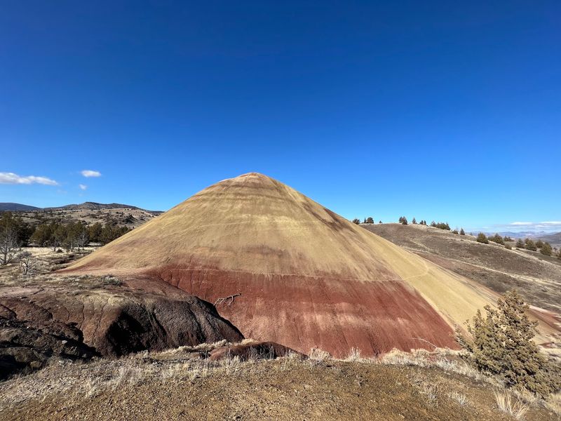
Somebody should tell these hills that stripes went out of style, but they’ve been wearing them for millions of years. The Painted Hills are rounded slopes banded in red, tan, orange, yellow, and black.
Those colors come from volcanic ash. Layers of ash settled over time, then weathered into soils with different minerals and shades.
The hills are part of the John Day Fossil Beds National Monument. Fossil beds here help tell the story of ancient plants and animals in the area.
Easy hiking trails let you see the colors up close. You don’t need to be a mountain goat to enjoy the views.
For a close look at the layers, the Painted Cove area is a favorite. It shows the ash bands right beside you instead of far in the distance.
Light changes the scene throughout the day. Morning and evening can make the reds and golds look especially rich.
Please stay on trails here. The colorful soil is fragile, and footprints can last for years.
The hills sit near the small town of Mitchell in Wheeler County. It’s a quiet, open corner of eastern Oregon, so plan your snacks and fuel ahead of time.
The primary overlook is open 24 hours. That makes it easy to time your visit for the best light.
It’s wild to think these soft, pretty hills came from volcanic ash. Proof that even explosive beginnings can turn into something calm and colorful.
Address: Painted Hills, Mitchell, OR 97750
8. Fort Rock State Natural Area
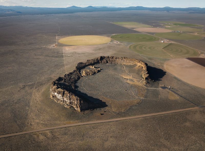
Out in the flat desert, a giant stone wall curves up like a castle somebody forgot to finish. Fort Rock is a huge volcanic tuff ring rising from the basin floor.
Tuff rings form when rising magma meets water and explodes. The blast throws out ash and rock that piles into a circular ridge.
That’s what makes this place so striking. There’s almost nothing around it, so the formation looks even bigger than it is.
Fort Rock State Natural Area offers trails that suit families and casual hikers. The walks are easy, but the views feel like a big reward.
Bring your camera, because the rock walls make great photos. Light shifting across the curved cliffs can change the look throughout the day.
The area is also tied to ancient human history. Caves in the region have turned up very old artifacts, which adds a whole extra layer of wonder.
Practical stuff is covered too. You’ll find picnic tables and public restrooms, and dogs are welcome.
A picnic in the shadow of an ancient explosion? That’s a lunch story worth telling.
Since the setting is remote high desert, pack water and snacks before the drive. Services out here can be few and far between.
This spot shows how Oregon volcanoes didn’t just build mountains. Sometimes they built giant stone rings that look like forts, which is exactly how the place got its name.
Address: Fort Rock Rd, Fort Rock, OR 97735
