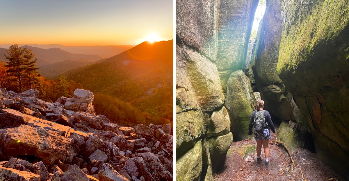
Some views feel earned after hours of climbing. Others feel like a gift, offering a stunning payoff without the punishing ascent.
This list has ten Virginia hikes with views that look like they should require much more effort. These are the trails where you can reach a summit in under an hour and still feel like you have accomplished something.
Some are short loops with overlooks that stretch for miles. Others are gentle climbs that reward you with panoramas of valleys, rivers, and ridges.
A few are so easy that you can bring kids or grandparents along. The common thread is the payoff.
These trails prove that you do not need to suffer to see something spectacular. Whether you are a casual walker or a seasoned hiker looking for a quick fix, these hikes deliver.
Bring a camera and enjoy the view.
1. Humpback Rocks, Lyndhurst, Virginia
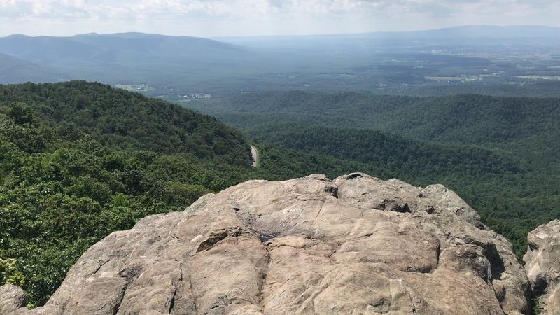
Short trail, big drama, and legs that will absolutely file a complaint. Humpback Rocks is the Blue Ridge Parkway’s favorite trick, a quick climb that hands you a view most mountains make you earn over a full day.
The path starts at the parking area just past the visitor center and heads straight uphill. There is no warm-up act here.
Switchbacks, rocky steps, and a final stone staircase lead you to a jagged outcrop that looks like a giant hunched over the ridge.
Up top, the scenery spreads out in every direction. The Shenandoah Valley rolls off to the west, while the Rockfish Valley and layer after layer of blue ridges fill the rest of the frame.
Sunrise here feels like someone cranked the color settings to maximum.
Before you start, save time for the Mountain Farm Trail beside the visitor center. It is an easy stroll past a cluster of relocated log buildings that show how mountain families lived and farmed in the nineteenth century.
Kids love the old cabin and farm sheds, and adults love that it is flat.
A few smart moves make the day smoother. Arrive early, because the lot fills fast on sunny weekends and during peak leaf season.
Wear real shoes, since the rocks at the summit can be slick and the edges drop off sharply.
Keep a respectful distance from the cliff edge, especially with little ones.
Address: Humpback Rocks Visitor Center, Blue Ridge Parkway Milepost 5.8, Lyndhurst, VA 22952.
2. McAfee Knob, Catawba, Virginia
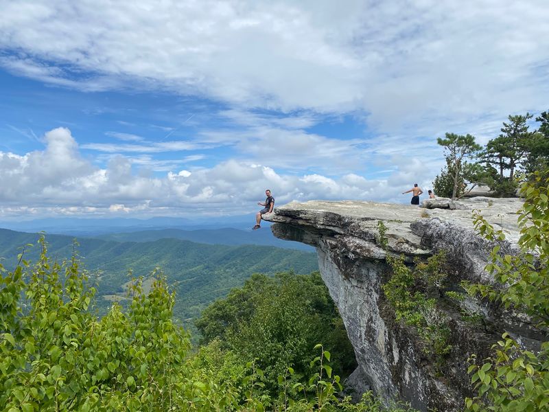
Confession time. McAfee Knob is the one entry on this list that asks for a real afternoon of walking, yet the grade is so steady that the climb sneaks by while you chat.
The reward is often called the most photographed spot on the entire Appalachian Trail. A flat slab of rock juts out over thin air like a diving board for giants, and the Catawba Valley sprawls below in a quilt of farms and forest.
Tinker Cliffs lines up to the north, and the Roanoke Valley glows off to the east.
Getting to the trailhead is safer than ever. A pedestrian bridge now carries hikers over busy Route 311, so nobody has to sprint across traffic with a backpack.
From there, you can follow the Appalachian Trail through the woods or use the wide fire road for part of the route, which makes the return trip feel like a gentle glide.
Parking is the real boss battle. The small lot fills early on bright weekends, and parking along the road is not allowed.
Start at dawn and you get cooler air, softer light, and far more elbow room on the ledge.
Want the famous shot? Keep the dangling-feet pose for calm, dry days, and stay well back from the lip when the wind picks up.
Pack plenty of water, a snack, and a layer, since the summit breeze can bite even in summer.
Address: McAfee Knob Trailhead, Route 311 (Catawba Valley Drive), Catawba, VA 24070.
3. Blackrock Summit, Shenandoah National Park, Virginia
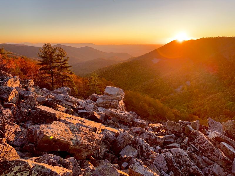
Some views make you work for every inch. Blackrock Summit is not one of them, and that is exactly why it deserves a spot at the top of your Skyline Drive plan.
The loop from the Blackrock parking area is short, shady, and so gently graded that toddlers and grandparents can keep pace. You ride a piece of the Appalachian Trail for part of the walk, then the trees suddenly part and reveal a jumble of dark, jagged rock piled up like a giant spilled a bucket of building blocks.
Those boulders get their moody color from lichen coating the stone. Climb onto the edge of the rock field and the Shenandoah Valley opens wide to the west, with farm fields and far-off ridges stacking toward the horizon.
Sunset here turns the whole scene gold, then pink, then a deep dusky blue.
Families get an extra bonus. The trail is part of the Kids in Parks TRACK Trail program, which offers free activity guides that turn the walk into a nature scavenger hunt.
Leashed dogs are welcome too, which is not true on every Shenandoah trail.
Scrambling around on the talus is tempting, but the rocks can wobble and hide gaps between them. Stick to the stable edges and keep a close eye on small hikers with big ambitions.
A park entrance pass is required for Skyline Drive, so grab one online before you roll in.
Address: Blackrock Summit Parking Area, Skyline Drive Milepost 84.4, Shenandoah National Park, near Grottoes, VA 24441.
4. Bearfence Mountain, Shenandoah National Park, Virginia
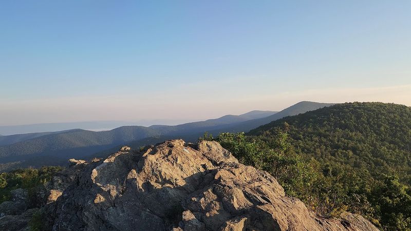
Hands on the rock, sneakers gripping, heart doing a little drum solo. Bearfence Mountain packs the thrill of a real mountaineering day into a loop so short you could finish before your coffee gets cold.
The trail climbs quickly from Skyline Drive, then turns into a rock scramble along a narrow spine of ancient volcanic greenstone. You will use your hands, pick your footing, and occasionally wonder who designed this jungle gym.
The answer is ancient lava flows and a very long stretch of time, and nature nailed the design.
At the top, you get one of the few true all-around panoramas in Shenandoah National Park. Ridges ripple north and south, the Shenandoah Valley stretches out to the west, and the Piedmont fades into soft blue haze toward the east.
Not a fan of scrambling? Skip the rocks by following the Appalachian Trail portion of the loop, which leads to a viewpoint with a gentler approach.
You still get a slice of the scenery without the gymnastics.
Timing matters on this one. Wet or icy rock turns the scramble from fun to foolish, so save it for dry days.
Gloves help, and shoes with grippy soles matter more than fancy gear.
Leave the dog at home for this outing, since pets are not allowed on the Bearfence rock scramble. Small kids can manage with plenty of help, though a fear of heights will get tested.
Address: Bearfence Mountain Parking Area, Skyline Drive Milepost 56.4, Shenandoah National Park, near Stanardsville, VA 22973.
5. Stony Man Trail, Shenandoah National Park, Virginia
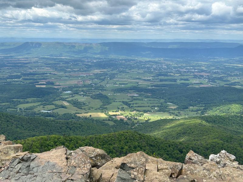
Squint at the cliffs from the valley below and you might spot a bearded face staring back. Settlers named this peak Stony Man for that rocky profile, and the summit delivers one of the grandest views in the park for surprisingly little sweat.
The walk begins at the Stony Man parking area near Skyland and follows a smooth stretch of the Appalachian Trail before splitting onto the summit loop. The grade stays friendly, the path stays wide, and the forest of oak and birch keeps things shady on warm afternoons.
Then the trees give way to open rock. Below you, the town of Luray sits tucked into the Shenandoah Valley, while Massanutten Mountain runs like a long green wall across the middle.
On clear days, the Alleghenies line the far edge of the sky.
Standing up here means standing on the second-highest peak in Shenandoah National Park, and only Hawksbill beats it. Not bad for a stroll that fits between breakfast and lunch.
Wildlife fans, keep your eyes on the air. The park has worked for years to bring peregrine falcons back to its cliffs, and these speedy hunters sometimes zip past the ledges.
Binoculars earn their spot in your pack here.
Dogs are not permitted on this trail, so plan accordingly. The rocks at the top can be uneven, and the drop-offs are real, so give the edges plenty of space.
Address: Stony Man Parking Area, Skyline Drive Milepost 41.7, Shenandoah National Park, near Luray, VA 22835.
6. Sharp Top Mountain, Bedford, Virginia
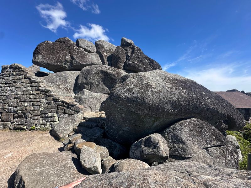
Here is a peak with serious bragging rights. Folks in Bedford County once believed Sharp Top was the tallest mountain in Virginia, and they were so proud of it that a stone from the summit was sent to Washington for the Washington Monument, labeled as coming from the state’s loftiest peak.
Spoiler, it is not the tallest. The view does not care one bit.
From the rocky crown, the Peaks of Otter area spreads out below, with Abbott Lake shining like a dropped coin and the Piedmont rolling east toward the horizon.
The trail is short but steep, climbing steadily from the Peaks of Otter area through woods and over plenty of rock steps. Expect to pause for air a few times.
Near the top, a spur leads to Buzzard’s Roost, a quieter perch with its own dramatic outlook.
In past seasons, a shuttle has carried folks most of the way up, leaving only a short, rugged finish on foot. Service can change from year to year, so check with the Peaks of Otter area before counting on a ride.
On the summit, a small stone shelter offers a break from the wind. Giant boulders stack up like nature’s bleachers, perfect for soaking in the Blue Ridge ripple in every direction.
Afterward, stroll the flat path around Abbott Lake at the base. It is easy, gorgeous at sunset, and a sweet reward for tired calves.
Address: Peaks of Otter, Blue Ridge Parkway Milepost 86, near 85919 Blue Ridge Parkway, Bedford, VA 24523.
7. Spy Rock, Montebello, Virginia
Legend has it that lookouts once scanned the valleys from this granite dome during the Civil War, watching for troop movements. One look from the top and the story makes perfect sense, because nothing sneaks past you up here.
Spy Rock rises above the forest near Montebello in Nelson County, a bald knob of pale stone that feels miles from everywhere. The final push involves a hands-and-feet scramble up the rock face, short but thrilling enough to get your pulse going.
Once you crest the top, the whole horizon unrolls in a complete circle.
Look for The Priest and the Religious Range stacked nearby, with rows of blue ridges fading into the distance. Sunrise and sunset are the headline acts here, and clear autumn evenings practically glow.
Getting there takes a little planning. The old fish hatchery lot is closed, and parking now sits at the end of Meadows Lane, a narrow and bumpy road where a high-clearance vehicle makes life easier.
Drive slowly, stay patient, and never block the private driveways along the way.
From the lot, a connector route links to the Appalachian Trail, which carries you toward the side path to the summit. The climbing is steady and rocky, so sturdy boots beat sneakers.
Stargazers, take note. Far from city lights, the night sky here can be spectacular, so pack a headlamp if you linger.
Address: Spy Rock Trailhead, end of Meadows Lane (Route 826), Montebello, VA 24464.
8. Buffalo Mountain Natural Area Preserve, Willis, Virginia
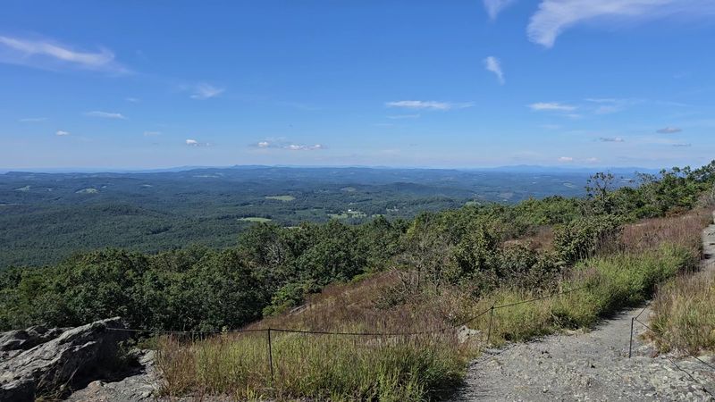
From a distance, the mountain’s silhouette looks like a sleeping buffalo resting on the Floyd County skyline, which is how the peak earned its name. Up close, it turns out to be one of the strangest and most special places in Virginia.
The summit is bald and windswept, covered in grasses and low plants instead of towering trees. Magnesium-rich soil and harsh mountaintop weather create a rare habitat where unusual plants and insects survive, some of them found almost nowhere else.
Botanists get as giddy here as kids in a candy store.
The trail from the parking lot is short and moderately steep, weaving through oak forest before breaking into the open. Suddenly the whole world seems to fall away.
Rolling farmland, forested ridges, and the Blue Ridge Plateau stretch out in waves that shift color with every passing cloud.
Protecting this spot matters. Stay on the marked trails and the summit loop, because the fragile barrens plants cannot bounce back from trampling boots.
No picking, no rock stacking, and no wandering off path for a better selfie angle.
Even on a mild day, a jacket up top can feel like a genius decision, and the bald summit offers no shade on hot afternoons.
Fall paints the surrounding hills in fiery shades, while late spring brings blooms across the grassy barrens. Floyd itself sits close by, known for its lively music scene and artsy small-town charm.
Address: Buffalo Mountain Natural Area Preserve, 890 Moles Road SW, Willis, VA 24380.
9. Channels Trail, Saltville, Virginia
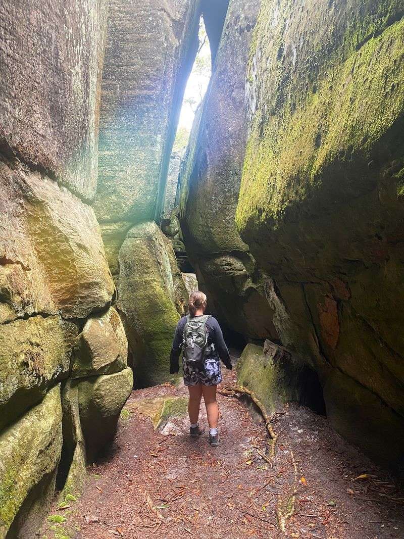
Somebody check the map, because this looks like Utah. Tucked high on Clinch Mountain in southwest Virginia, The Channels is a maze of sandstone passages so narrow and twisty that it feels like wandering the hallways of a giant stone castle.
Scientists believe the channels formed during the last ice age, when repeated freezing and thawing pried apart the sandstone along cracks. Today those cracks have grown into slots deep enough to swallow you whole, lined with moss, ferns, and cool air even on steamy summer days.
Honesty time. The hike to reach them is a steady uphill trek, following the Brumley Mountain Trail and then the Great Channels Trail through leafy forest.
The good news is the grade is manageable, and the payoff feels like visiting another planet.
Near the top of Middle Knob, an old fire tower stands close to the channels, and nearby openings offer sweeping looks across the surrounding mountains. Pair the long-range views with the shadowy slots below and you get two adventures for the price of one.
Inside the maze, it is easy to lose your bearings. Keep track of where you entered, bring a light for the darker corners, and wear shoes with solid grip for mossy rock.
The trailhead lot along Hayters Gap Road is small, so an early start is a must. Pack plenty of water, since there is no reliable source along the route.
Address: Great Channels Trailhead, Hayters Gap Road (Route 80), near Saltville, VA 24370.
10. Comers Rock Lookout Tower, Speedwell, Virginia
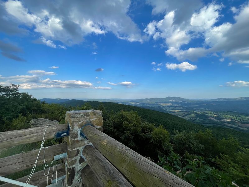
Lazy hikers, this finale is your moment of glory. Comers Rock serves up a mountaintop panorama after a walk so short it barely counts as exercise, and nobody needs to know that part.
Perched on Iron Mountain in the Mount Rogers National Recreation Area, the overlook sits on the stone base of an old fire lookout. The original tower is long gone, but a sturdy viewing platform now crowns the rock.
A brief path from the parking area gets you there in minutes.
From the top, the view feels enormous. Forested ridges roll away in every direction, with the Elk Creek valley spread out below and distant peaks like Buck Mountain and Point Lookout Mountain stacking along the horizon.
Fall foliage turns the whole scene into a painter’s palette.
Make a day of it. The small Comers Rock campground nearby offers rustic, peaceful sites under the trees, and little Hale Lake sits a short drive away for fishing, paddling, and lazy lakeside naps.
Gravel Forest Service Road 57 winds up from Route 21, so take it slow and keep an eye out for wildlife crossing.
So there you have it, a whole lineup of Virginia views that punch way above their weight. Grab your boots, fill a water bottle, and go claim a summit before your couch files a missing person report.
The mountains are waiting, and they are not great at patience.
Address: Comers Rock Recreation Area, Forest Service Road 57, near Speedwell, VA 24374.
