You do not expect to find history this old just sitting out in the open, but Oregon has a way of keeping its secrets visible. This loop trail winds through forest and canyon, past three gold mines that have been empty for more than a century. The first two are quiet, just dark openings in the rock with tailings scattered down the slope.
But the third one still has its original timber supports, hand hewn and placed there in 1897, holding up the ceiling like they have been waiting for someone to notice. I stood at the entrance, felt the cold air coming out of the tunnel, and tried to imagine the men who crawled inside looking for fortune. Oregon has plenty of scenic hikes, but this one lets you walk through actual history.
The Elkhorn Crest Trail and the 14-Mile Loop Overview

My first look at the Elkhorn Crest National Recreation Trail map made me realize this place is far more layered than a simple day hike. The trail system spans over 22 miles total, but a well-planned 14-mile loop gives you access to some of the most historically rich terrain in eastern Oregon.
You are threading through the Blue Mountains, and every switchback feels like it is pulling you deeper into a forgotten chapter of American history.
The loop connects segments near Marble Pass and works its way toward Cracker Saddle, passing through open alpine meadows and dense stands of pine and fir. Elevation changes keep things interesting without being punishing.
The trail is rated as moderate, making it accessible to hikers with a reasonable fitness level and proper footwear.
One section of the Elkhorn Crest Trail between Marble Pass and the wilderness boundary is open to mountain bikes, which adds some flexibility for how you choose to experience it. The road to the trailhead is rough, so a high-clearance vehicle is strongly recommended.
Starting from the south side near Baker City is generally considered the more practical approach, and the views from the upper ridgeline on a clear day are genuinely hard to put into words.
Sumpter, Oregon, The Gold Rush Town That Started It All

Sumpter is one of those towns that feels like it got paused somewhere around 1910 and nobody noticed. It sits in the Powder River Valley, tucked into the Blue Mountains, and it carries the weight of its gold rush past in every weathered building and rusted artifact.
Gold was discovered in the area in 1862, but it was the arrival of the railroad in 1897 that turned Sumpter into a genuine boomtown almost overnight.
At its peak, the town supported miners, merchants, sawmill workers, and everyone in between. The North Pole-Columbia Lode, located about seven miles north near the old town of Bourne, was one of the most productive gold-producing sites in Oregon during the late 1890s, responsible for over a quarter of the state’s total gold output between 1896 and 1900.
That is not a small number.
Today, Sumpter is a quiet community with a population that fits comfortably on a single street. The Sumpter Valley Dredge State Heritage Area gives visitors a close-up look at the massive gold dredge that worked the valley floor for decades.
Starting your hike from this area connects the modern trail experience directly to the industrial-scale mining history that shaped this entire region.
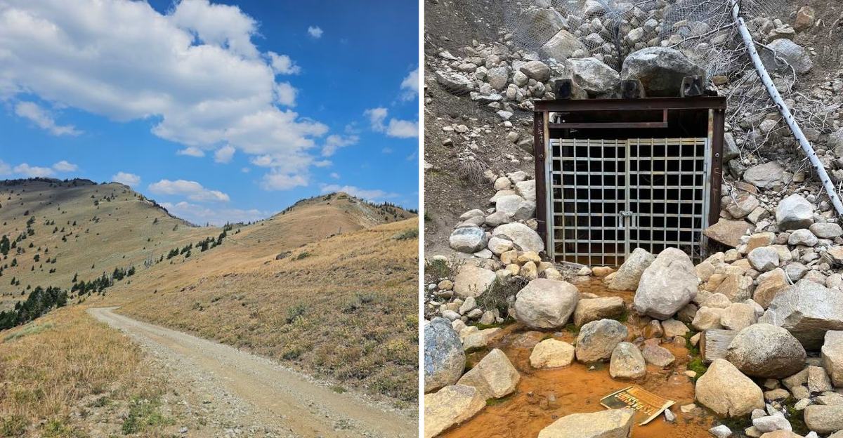
The First Abandoned Mine, North Pole Mine and Its Underground World

Reaching the first mine on this loop feels like stumbling onto a movie set that nobody bothered to clean up after production wrapped. The North Pole Mine is one of the anchor sites of the North Pole-Columbia Lode, a stretch of mineralized rock that extends for over five miles near the old town of Bourne.
At its most active, this mine was part of a network that reportedly included up to 12 miles of underground tunnels.
The scale of that is hard to picture until you are standing at the entrance and looking into the dark. Timber framing lines the shaft openings, most of it long since sagged or collapsed under the pressure of time and mountain weather.
The North Pole Mine had extensive underground shafts, and the infrastructure built to support them was substantial for its era.
Approaching this site, you notice the way the hillside has been reshaped by human hands. Tailings piles, flattened ground, and fragments of old equipment all point to just how much labor went into extracting gold from this mountain.
It is worth pausing here longer than you think you need to. The quiet around an old mine entrance has its own kind of texture, equal parts eerie and deeply human.
You can almost hear the echo of pickaxes striking rock if you stand still enough and hold your breath. The forest has been reclaiming this place for decades, swallowing the waste piles and crumbling the wooden structures, but the bones of the operation remain.
A reminder that even in the middle of Oregon’s wilderness, people once worked themselves raw chasing a dream that most of them never found.
The Columbia Mine: Where the Timber Mill Fed the Tunnels

Not every mine on this loop is a pile of rubble. The Columbia Mine has a particular character that sets it apart, partly because of how much supporting infrastructure was built around it.
The Columbia Mine operated from 1897 to 1914, and the property included its own sawmill specifically to produce the lumber needed for underground tunnel supports and surface structures. That level of self-sufficiency tells you a lot about how remote and ambitious this operation was.
The mining mill for the Columbia Mine was constructed in 1896, just ahead of the railroad’s arrival, which suggests the operators were planning ahead with real confidence. Evidence of collapsed timbers is still visible at the site, giving you a tangible sense of what the underground framework once looked like.
Some of those beams have been lying in the same position for over a century.
Hiking through this section of the loop, the forest has largely reclaimed what the miners left behind. Young trees grow through old foundations.
Moss covers timber that once held up thousands of tons of mountain. It is a slow, patient kind of erasure, and yet the bones of the operation are still clearly readable if you know what you are looking at.
A little research before your hike goes a long way here.
Wildlife, Views, and the Mountain Goats Nobody Warned You About

The mines are the headline, but the trail itself is the full story. The Elkhorn Crest area is one of those places where the scenery shifts dramatically every mile or so, from dense conifer forest to open rocky ridgelines with views stretching across the Baker Valley and beyond.
In October, the fall colors hit a level that is genuinely hard to describe without sounding like you are exaggerating.
Mountain goats are a real and frequent presence on this trail. Multiple hikers have reported getting surprisingly close to herds grazing on the upper slopes, seemingly unbothered by human company.
There is something almost absurdly charming about rounding a corner expecting another mine ruin and finding a group of goats instead, staring back at you with complete indifference.
Deer, hawks, and the occasional black bear are also part of the ecosystem here, so carrying bear spray and making noise on the trail is sensible practice. The upper sections of the loop can hold snow well into June, so checking conditions before heading out is important.
The views from the ridgeline on a clear day are the kind that make you stand still for a few minutes, not for a photo, just to actually look. That feeling is harder to find than most people expect.
Planning Your Hike, What to Bring, When to Go, and How to Get There

Getting to the Elkhorn Crest Trail requires a bit of planning, but nothing that should discourage a reasonably prepared hiker. The trailhead is accessible via Forest Road 6510 near Baker City, and the road is rough enough that a high-clearance vehicle is genuinely useful, not just a suggestion.
The GPS coordinates for the Elkhorn Crest National Recreation Trail put it at approximately 44.77 degrees north, 118.04 degrees west, near Baker City, Oregon.
The best hiking window runs from late June through early October, depending on snowpack. Early July often still has snow patches on the upper sections, which can be fun or frustrating depending on your footwear.
Mid-August through September tends to offer the most reliable conditions, with warm days, cool nights, and minimal precipitation.
Pack for a full day even if you plan a shorter version of the loop. Water sources exist along the trail, but carrying a filter is safer than relying on them.
Layers are essential because the ridgeline can be significantly cooler and windier than the trailhead. Sturdy hiking boots with ankle support will serve you much better than trail runners on the rockier sections near the mine sites.
The trail is open 24 hours year-round, though overnight camping requires checking current regulations with the Wallowa-Whitman National Forest.
Address: NF-6510, Baker City, OR 97814
Dear Reader: This page may contain affiliate links which may earn a commission if you click through and make a purchase. Our independent journalism is not influenced by any advertiser or commercial initiative unless it is clearly marked as sponsored content. As travel products change, please be sure to reconfirm all details and stay up to date with current events to ensure a safe and successful trip.