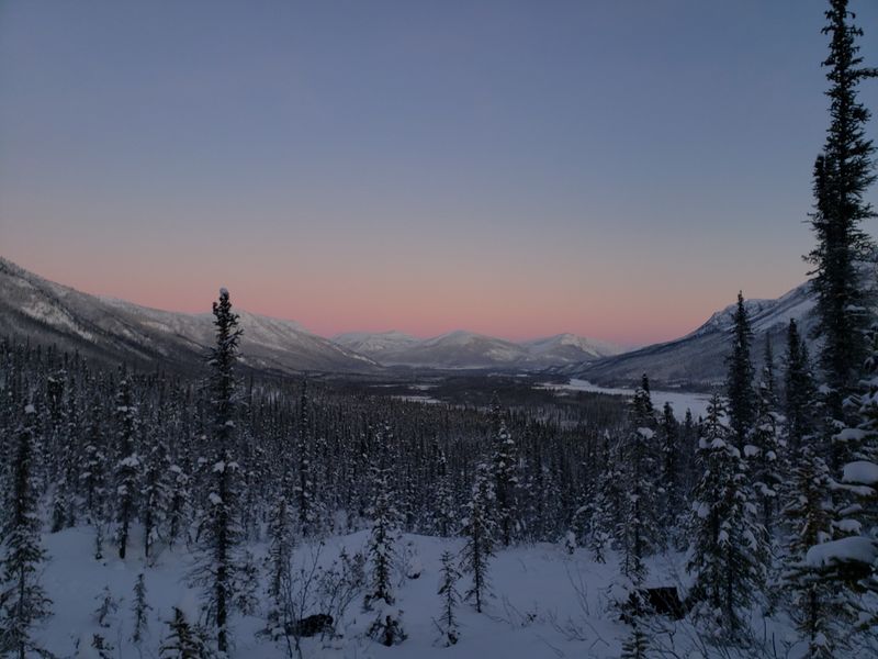
Alaska stretches across vast wilderness where roads don’t follow the rules you might expect from the rest of the country.
Some settlements along these remote routes become nearly impossible to reach for most of the year, locked away by snow, mud, river floods, and unpredictable weather.
Only during brief summer windows do these places open up to travelers willing to take the gamble on rough highways and shifting conditions.
These aren’t your typical roadside towns with year-round access and predictable traffic patterns. Instead, they represent a unique slice of Alaskan life where timing matters as much as determination, and where the journey itself becomes part of the adventure.
Understanding when and how to reach these isolated communities offers a glimpse into how Alaska’s road system operates more like a seasonal network than a permanent grid, reminding us that nature still holds the upper hand in the far north.
1. Wiseman
Perched north of the Arctic Circle, Wiseman represents one of Alaska’s most remote roadside communities where the calendar dictates who gets in and who stays out.
The Dalton Highway serves as the lifeline to this settlement, but that lifeline pulses with activity only during short summer and early fall windows.
Outside those precious weeks, road conditions deteriorate rapidly, and weather patterns turn hostile even for drivers who’ve spent years navigating Alaska’s toughest routes.
Wiseman emerged during the gold rush era, and its handful of year-round residents maintain a lifestyle that feels frozen in time.
Visitors who time their arrival correctly find themselves stepping into a world where modern conveniences take a backseat to self-reliance and community bonds.
The settlement sits at milepost along the highway, surrounded by mountains and tundra that stretch endlessly in every direction.
Summer brings nearly constant daylight, transforming the landscape into a realm where time loses its usual meaning.
Travelers need to prepare thoroughly before attempting the journey, as services remain sparse and emergencies require serious planning.
The road itself becomes an attraction, winding through terrain that shifts from forested valleys to open tundra.
Wildlife sightings happen frequently, with caribou, bears, and birds appearing along the route.
Wiseman’s accessibility window typically opens in late spring and closes by early fall, though exact timing varies each year based on snowmelt and weather patterns.
Those who make the journey often describe it as a pilgrimage to a place where Alaska’s wild character remains unfiltered and authentic.
2. Coldfoot
Coldfoot earned its unusual name from miners who got cold feet about venturing further north during gold rush days, and modern travelers sometimes experience similar hesitation.
This settlement occupies a critical stretch of the Dalton Highway, functioning more as a seasonal waypoint than a traditional town with year-round bustle.
Access depends almost entirely on summer maintenance schedules and brief periods when weather cooperates with travel plans.
The community serves truckers hauling supplies to northern oil fields, along with adventurous tourists chasing the Arctic Circle experience.
During accessible weeks, Coldfoot buzzes with activity as travelers stop to refuel vehicles, grab meals, and share stories about road conditions ahead.
Winter transforms this outpost into an isolated pocket where only the most essential traffic attempts passage.
The settlement sits roughly halfway along the Dalton Highway’s length, making it a natural stopping point for those tackling the full route.
Summer temperatures remain surprisingly mild, though mosquitoes arrive in legendary swarms that test even the most patient visitors.
The surrounding landscape features dramatic mountain ranges and river valleys that showcase Alaska’s raw beauty without filters or exaggeration.
Coldfoot’s brief season of accessibility creates a compressed timeline where experiences intensify and every encounter feels significant.
Travelers heading north from Fairbanks watch as civilization gradually fades, with Coldfoot representing one of the last outposts before true wilderness dominates.
The settlement reminds visitors that convenience isn’t guaranteed in Alaska, and that reaching certain destinations requires both planning and flexibility.
3. McCarthy
McCarthy sits at the end of a legendary road that crosses flood-prone rivers and terrain so remote that cell service becomes a distant memory.
Dependable access exists only during a narrow summer window when rivers settle and road crews manage to patch the worst damage from winter.
Outside that period, conditions force even determined travelers to abandon their attempts long before town comes into view.
The journey to McCarthy follows the old railroad bed that once hauled copper ore from nearby mines, and that history lingers in every mile.
Summer visitors find a community that embraces its isolation, with residents who chose this lifestyle specifically because it keeps the outside world at arm’s length.
The road requires crossing a footbridge after parking vehicles, adding a final layer of adventure to the arrival experience.
McCarthy’s brief accessibility season concentrates activity into intense weeks where tour operators, lodge owners, and local businesses scramble to serve visitors.
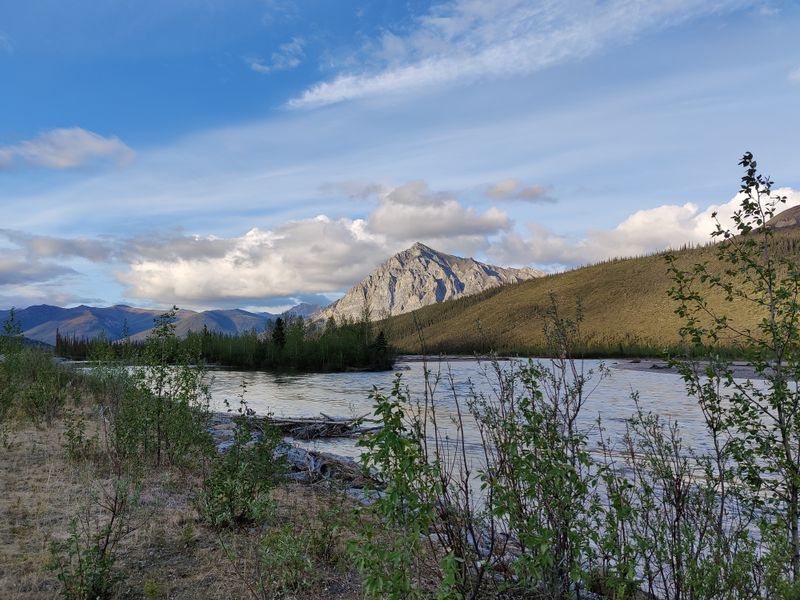
The surrounding Wrangell Mountains provide a backdrop so stunning that photographs rarely capture the full impact.
Glaciers flow down valleys visible from town, and hiking trails lead into wilderness that remains largely unchanged from centuries past.
McCarthy represents a different pace of life, where schedules bend around weather and where community members know each other’s stories intimately.
The settlement’s seasonal nature means that timing a visit requires flexibility, as road conditions can shift rapidly based on rainfall and snowmelt.
Those who successfully reach McCarthy often describe feeling like they’ve discovered a secret that most travelers never experience.
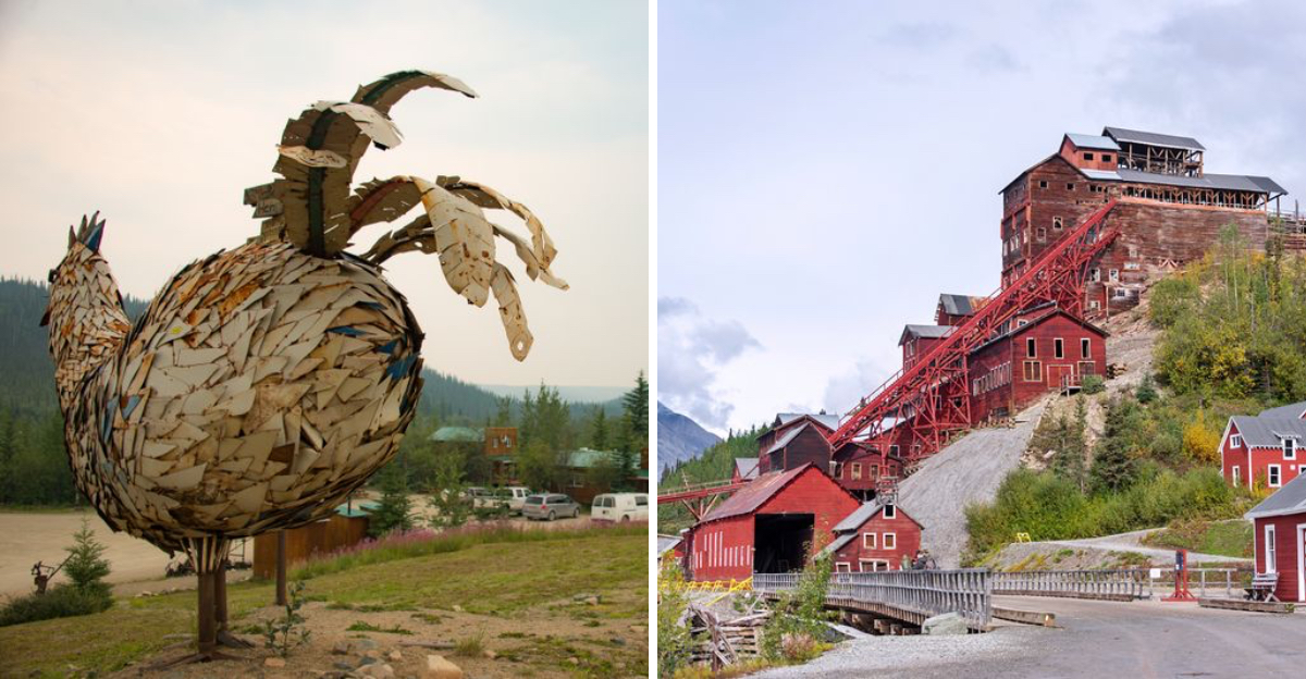
4. Kennicott
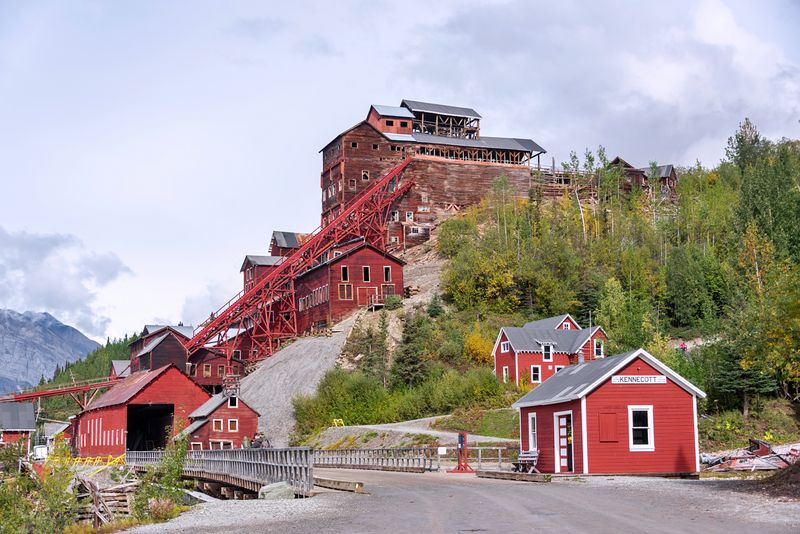
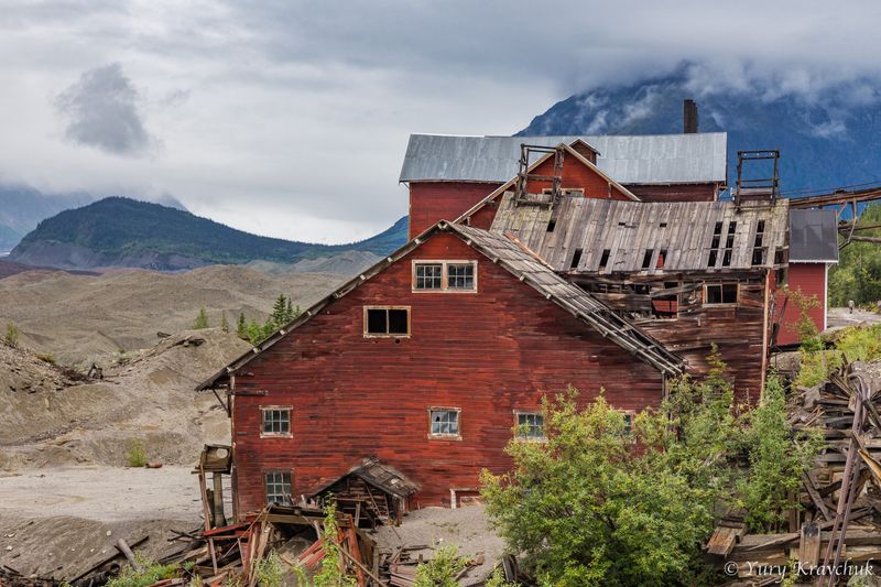
Just beyond McCarthy, Kennicott rises from the landscape like a ghost from Alaska’s copper mining past, its red buildings stark against mountain slopes.
This settlement relies on the same fragile road access as McCarthy, with snowmelt, washouts, and bridge conditions restricting reliable travel to mere weeks annually.
The historic mining structures have been preserved, creating an outdoor museum where visitors walk through buildings that once housed hundreds of workers.
Kennicott’s remote location protected it from development pressures, leaving the site remarkably intact compared to other abandoned mining camps.
Summer brings guided tours through mill buildings where copper ore was processed, and interpretive displays explain the industrial processes that once dominated this valley.
The Root Glacier flows nearby, offering hiking opportunities for those willing to venture onto the ice with proper equipment and guidance.
Kennicott’s accessibility window aligns with McCarthy’s, creating a compressed season where both communities welcome visitors before winter reclaims the region.
The settlement sits within Wrangell-St. Elias National Park, surrounded by peaks that rank among North America’s tallest and most dramatic.
Visitors often combine trips to both McCarthy and Kennicott, experiencing the contrast between a living community and a preserved historic site.
The journey to reach Kennicott feels like traveling backward through time, with modern conveniences stripped away mile by mile.
Weather patterns shift quickly in this mountain environment, and travelers learn to respect nature’s authority over human schedules.
Kennicott stands as a testament to human ambition and nature’s ultimate dominance, a place where history and wilderness merge into something unforgettable.
5. Circle
Circle occupies the terminus of the Steese Highway, where pavement gives way to gravel and road conditions beyond Fairbanks fluctuate dramatically with seasons.
Late spring and summer provide the most dependable access before seasonal deterioration transforms the route into a challenging proposition.
The settlement sits near the Yukon River, offering visitors a glimpse of Alaska’s interior where rivers serve as highways and isolation defines daily life.
Despite its name, Circle doesn’t actually sit on the Arctic Circle, though early prospectors mistakenly believed it did when they established the community.
The Steese Highway winds through gold mining country where dredges and tailings piles still mark the landscape from decades of extraction.
Summer visitors to Circle find a quiet community where fishing, subsistence activities, and tourism support the small population.
The journey from Fairbanks takes several hours even during optimal conditions, with the road climbing through mountain passes and descending into river valleys.
Wildlife encounters happen regularly along the route, with moose, bears, and smaller animals frequently crossing the roadway.
Circle’s brief accessibility season creates a rhythm where residents prepare intensively during summer months for the long isolation of winter.
The Yukon River flows massive and muddy past the settlement, carrying water from distant mountains toward the Bering Sea.
Travelers who reach Circle often feel a sense of accomplishment, having completed a journey that tests both vehicles and determination.
The settlement represents an endpoint where Alaska’s road system simply stops, reminding visitors that not everywhere can be reached by car year-round.
6. Eagle
The Taylor Highway leading to Eagle remains passable only during a short summer season when snow, mud, and river crossings align favorably.
This historic settlement perches on the Yukon River, maintaining connections to Alaska’s territorial past through preserved buildings and local traditions.
Eagle served as a key checkpoint during gold rush days, and its strategic location continues to define its character and purpose.
The community embraces its isolation, with residents who appreciate the distance from urban Alaska and the lifestyle that remoteness permits.
Summer access brings visitors interested in history, river travel, and experiencing a town where the frontier spirit remains tangible.
The Taylor Highway challenges drivers with steep grades, narrow passages, and surfaces that shift from decent gravel to rough washboard.
Eagle’s brief window of road accessibility concentrates activity into weeks where supplies arrive, visitors explore, and preparations begin for winter isolation.
The Yukon River dominates the landscape, flowing wide and powerful past the settlement on its journey toward the Bering Sea.
Historic buildings include a courthouse and customs house that speak to Eagle’s role in territorial administration and border control.
Walking tours reveal stories of early settlers, indigenous peoples, and the challenges of establishing community in such remote territory.
The settlement sits just miles from the Canadian border, creating a sense of being on the edge of multiple frontiers simultaneously.
Eagle represents a lifestyle choice rather than a convenience, attracting people who value solitude and self-sufficiency over easy access to services.
Those who make the journey during accessible weeks discover a community proud of its heritage and protective of its unique character.
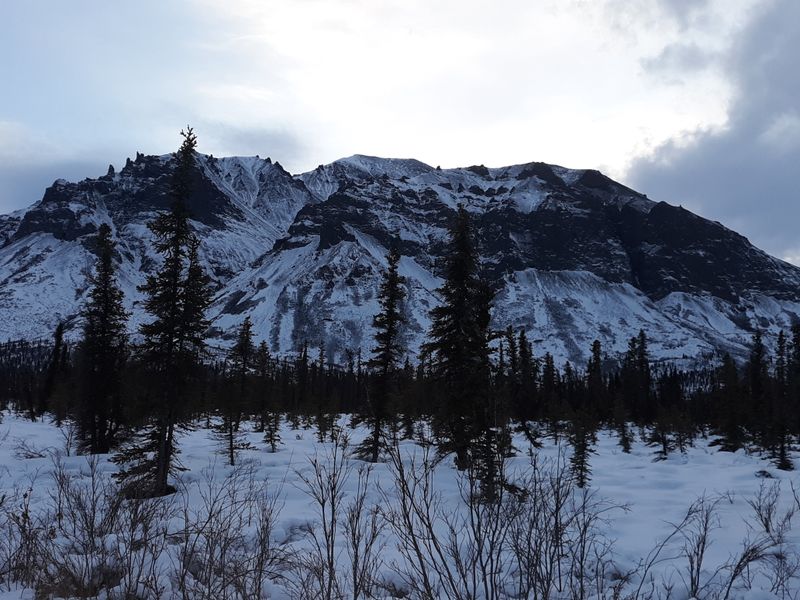
7. Nabesna
Nabesna Road leads into Wrangell-St. Elias National Park, but accessibility exists only during brief summer stretches when seasonal damage hasn’t overwhelmed minimal maintenance efforts.
The settlement at road’s end serves as a gateway to wilderness that stretches across millions of acres without development or permanent infrastructure.
Travelers attempting the journey face a rough route where river crossings, washouts, and surface conditions require high-clearance vehicles and careful navigation.
Nabesna itself consists of a small community where residents live surrounded by some of Alaska’s most spectacular mountain scenery.
The Wrangell Mountains rise dramatically around the valley, with volcanic peaks and massive glaciers dominating the horizon in every direction.
Summer’s accessible weeks bring hikers, climbers, and adventurers seeking trails that penetrate deep into the park’s backcountry.
The road deteriorates progressively as miles accumulate, with conditions worsening the further travelers venture from the highway junction.
Wildlife viewing opportunities abound, as the area supports populations of caribou, sheep, bears, and numerous bird species.
Nabesna’s remote location means that self-sufficiency isn’t optional but essential, with no services available once the main highway disappears behind.
The brief season of vehicle access creates urgency for those planning visits, as weather and road conditions can shift suddenly.
Park rangers and locals emphasize preparation, warning that help remains hours away even during the best conditions.
Nabesna represents raw Alaska, where human presence feels temporary against the permanent backdrop of mountains and wilderness that dwarf everything else.
8. Chicken
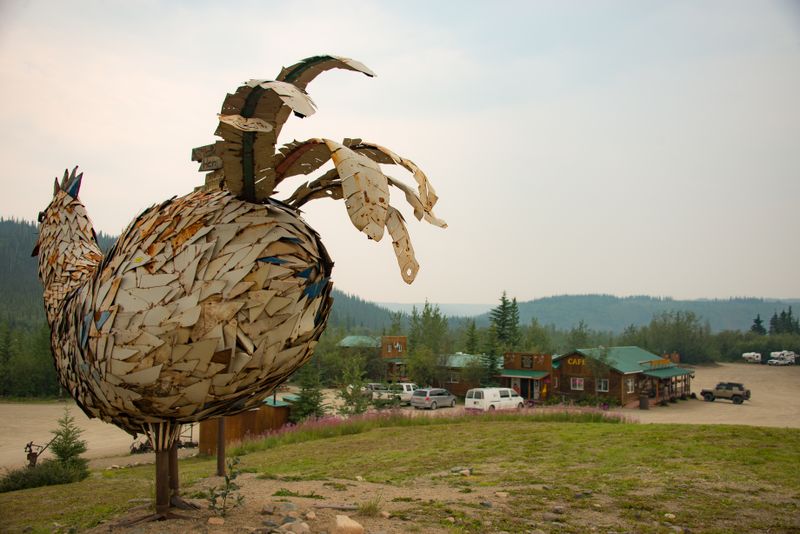
Despite its fame and unusual name, Chicken remains genuinely difficult to reach outside a narrow seasonal window dictated by the Taylor Highway’s condition.
The settlement earned its name when early miners couldn’t agree on how to spell ptarmigan, settling instead for the simpler alternative.
Summer brings tourists attracted by the quirky name and the authentic frontier atmosphere that persists in this tiny community.
Chicken consists of a handful of buildings including gift shops and cafes that embrace the town’s unusual identity with humor and pride.
The Taylor Highway’s condition fluctuates sharply depending on weather and maintenance schedules, creating uncertainty about when access remains reliable.
Travelers find that Chicken delivers on its promise of authentic Alaska experience, with no pretense or manufactured tourist attractions.
The surrounding landscape features rolling hills, mining scars, and patches of boreal forest that characterize Alaska’s interior.
Gold mining history permeates the area, with dredges and equipment still visible from the road and around the settlement.
Chicken’s brief accessibility season means that residents pack a year’s worth of activity into summer months before winter isolation returns.
Visitors often stop for photos with the town sign, collecting evidence of their journey to one of Alaska’s most memorably named places.
The community maintains a sense of humor about its fame while staying true to the hardscrabble reality of remote Alaskan living.
Road conditions approaching Chicken can deteriorate rapidly after rain, turning surfaces into muddy challenges that test vehicle capabilities.
Those who successfully reach Chicken during accessible weeks leave with stories about both the journey and the destination.
9. Chisana
Once connected by primitive road access, Chisana now becomes reachable by vehicle only during rare, favorable summer conditions when everything aligns perfectly.
Most of the year, travel reverts to air access as road deterioration makes ground transportation impractical or impossible even for experienced drivers.
This settlement ranks among Alaska’s most isolated, existing at the edge of Wrangell-St. Elias National Park where wilderness dominates in every direction.
Chisana’s gold rush history left behind buildings and stories, but the community shrank dramatically as mining operations ceased and easier locations attracted residents.
Those few who maintain year-round residence embrace extreme isolation, living without amenities that most Americans consider essential.
The brief window of potential vehicle access creates uncertainty, as travelers can’t reliably plan trips months in advance.
Road conditions depend on snowmelt timing, rainfall amounts, and whether anyone has attempted recent maintenance on the rough track.
Chisana sits surrounded by peaks and glaciers that define the Wrangell-St. Elias landscape, creating scenery so dramatic it feels almost unreal.
Summer brings nearly constant daylight, transforming the experience of visiting into something outside normal time perception.
The settlement represents the extreme end of Alaska’s seasonal road network, where access becomes more theoretical than practical for most travelers.
Air taxis serve as the primary connection, landing on rough strips that require skilled pilots and favorable weather.
Chisana embodies the ultimate Alaskan isolation, a place where nature dictates terms and human presence remains tentative and temporary against the vast wilderness backdrop.
Dear Reader: This page may contain affiliate links which may earn a commission if you click through and make a purchase. Our independent journalism is not influenced by any advertiser or commercial initiative unless it is clearly marked as sponsored content. As travel products change, please be sure to reconfirm all details and stay up to date with current events to ensure a safe and successful trip.