Arizona has a surprising lineup of dunes and sandy playgrounds that deliver big adventure with short travel times.
You can cruise mellow sand bowls, hike sculpted ridgelines, or soak in hot springs after a dusty ride.
This guide sticks to verified details so you can plan with confidence and avoid guesswork.
Expect practical tips, clean directions, and fun ideas that keep the day moving.
Pack water, check permits, and get ready to explore the best sand near Arizona this season.
1. Hot Well Dunes Recreation Area

Hot Well Dunes pairs easygoing sand riding with a rare desert soak that feels earned after a dusty loop.
The dunes are smaller than the big names in California, which makes them friendly for new riders and sand hikers who want quick rewards without a huge learning curve.
Soft morning light brings out subtle ripples and keeps temps manageable before the wind starts to shuffle the surface.
You reach the area by getting information and local conditions from the Bureau of Land Management at 711 14th Ave, Safford, AZ 85546.
The office is the practical stop for updates on road status, camping guidance, and seasonal fire restrictions that shift after summer storms.
The actual dunes sit farther out on graded dirt and can feel remote, so a high clearance vehicle is smart when washboards flare up after rain.
Expect dispersed camping, vault toilets at key pullouts, and dark skies that switch on the Milky Way when the moon cooperates.
Riding is open style with common sense etiquette, so scan crests before committing and keep speeds in check around camp clusters.
Wind can stack sharp slipfaces that challenge momentum, which is half the fun if you like reading terrain and picking smart lines.
Non riders can wander short ridges for photos, then settle at the tubs for a gentle soak that eases calf burn from sidehill traverses.
Pack extra water, sun protection, and a tire repair kit because the nearest services require a drive back toward Safford.
Cell coverage wavers, so share your route, download offline maps, and keep an eye on weather that can lift sand into brief ground blizzards.
2. Imperial Sand Dunes Recreation Area
The Imperial Sand Dunes are the classic big dunes playground with huge bowls, razorback ridges, and long sightlines that keep riders looping for hours.
If you are entering from Arizona, the Gecko Road corridor near Brawley is the popular staging zone with wide pads and clear signage that simplifies first time visits.
Mornings are prime for cool air and crisp texture that firms the surface before the sun softens the tops and edges.
The Cahuilla Ranger Station along Gecko Rd, Brawley, CA 92227 serves as a closest major entry point for updates, passes, and weekend advisories.
Expect heavy use on holiday periods, so arrive early, flag vehicles clearly, and keep a spotter handy when climbing blind crests with side traffic.
This is the place to practice throttle control and reading wind rows, because the scale rewards smooth arcs and clean commitment on climbs.
Rovers and hikers can roam leeward slopes for quiet, especially on weekdays when engines thin out and the dunes breathe.
Sunset lays warm light across the saddles and builds strong shadows that help you judge depth from a ridge before dropping in.
Permits are required and enforcement is routine, so handle paperwork ahead of time to skip lines and stress at the gate.
Bring goggles with low light lenses, two air filters for longer stays, and a backup flag because stakes sometimes loosen in churned sand.
Arizona day trippers often base in Yuma for fuel and supplies, then roll across in the morning for cooler hours and smoother traffic.
Keep a weather eye for wind advisories that can kick up sudden whiteouts and test your navigation between fixed landmarks.
3. Ehrenberg Sandbowl

Ehrenberg Sandbowl is a mellow, convenient sand pocket steps from I-10 that makes a quick session easy between longer road miles.
The bowl is compact yet varied, with wind carved ramps where you can practice turns, throttle timing, and hill checks without long approaches.
It suits side by sides and dirt bikes that want casual laps and quick breaks instead of a full backcountry mission.
Access comes from Ehrenberg-Cibola Road near Ehrenberg, AZ 85334, where graded spurs peel off toward open sand and firm wash bottoms.
Pullouts handle small groups and day setups, though holiday weekends can fill sightlines with trailers and require extra patience on crests.
Conditions shift fast after wind, so arrive early to enjoy smooth corduroy before mid day chop sets small whoops on popular lines.
The bowl edges have soft pockets that trap front tires if you square them, so favor diagonal exits and carry speed gently.
Hikers can climb the rim for views of the Colorado River corridor and the interstate ribbon that hums in the background.
There is no formal services grid, so pack water, shade, and a trash plan to keep the site clean for the next crew.
Cell signal is generally workable, which helps for maps and quick weather checks when gusts are forecast for the river valley.
Arizona travelers like the short distance to Quartzsite food and supplies, making it an easy add on during winter travel season.
Wrap up before sunset if you are new, since shadows can hide ruts and make the modest slopes feel steeper than they really are.
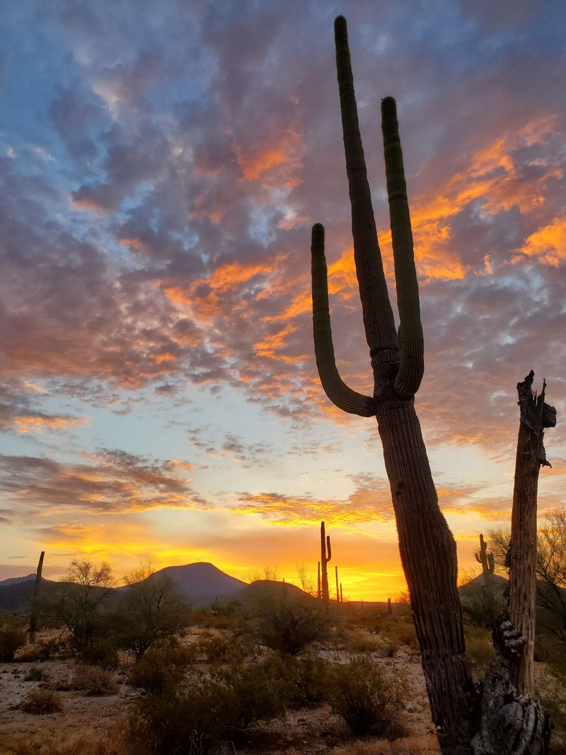
4. Monument Valley Sand Dunes
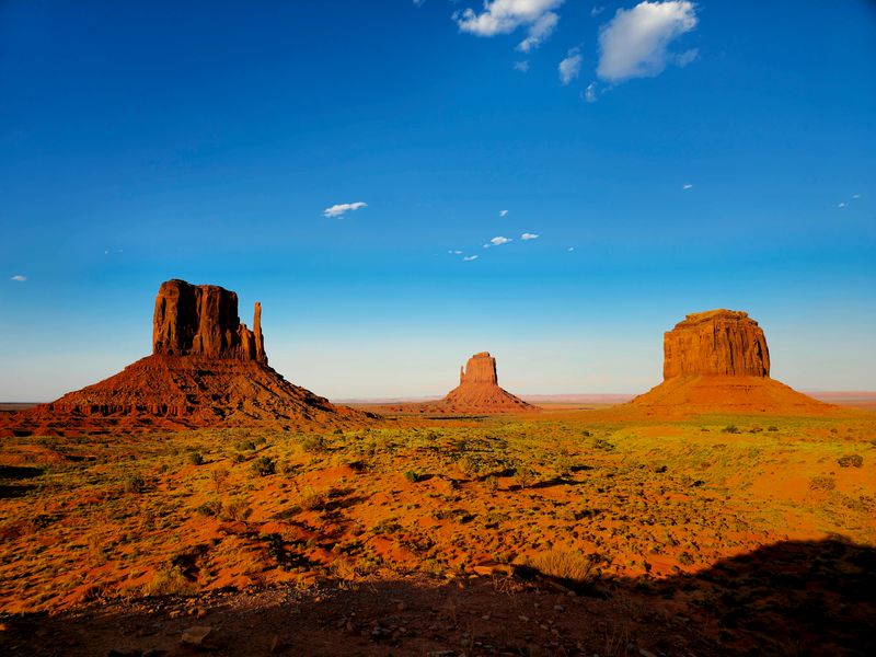
Monument Valley adds cinematic sand to a skyline of red buttes that deliver instant context for any road trip through the Navajo Nation.
Dune pockets appear near viewpoints and along guided routes where the wind piles soft drifts against sandstone shoulders and low shrubs.
The light shifts dramatically by hour, so plan two visits to compare morning clarity with the warm glow that washes in before sunset.
The Monument Valley Visitor Center along US 163 Scenic in Oljato-Monument Valley, AZ provides park information, guided tour bookings, and route updates.
Self driving is limited to the loop road when open, while deeper access usually requires a local guide who knows sandy sections and cultural etiquette.
Hikers should respect signed closures and stick to approved overlooks where the sand is stable and the views extend for miles.
Tripods and neutral density filters help balance dark buttes with bright sand, keeping photos clean without blowing highlights.
Wind can surge quickly, which adds mood but also throws grit at lenses, so bring a blower and microfiber cloth to keep gear clear.
Arizona travelers often pair this stop with a night in Kayenta or Page to break up miles and catch sunrise lines from multiple angles.
Local stories mention shifting dunes that sometimes reveal old tracks after storms, which is a legend rather than a confirmed historical record.
Carry water, modest clothing, and patience for checkpoints, then enjoy a measured pace that shows respect for residents and land protocols.
Your reward is that classic mix of rust colored monoliths and wind brushed sand that looks unreal even when you are standing there.
5. Three Dunes Trail at Lake Havasu

The Three Dunes Trail near Lake Havasu is a short, sandy hike with clean sightlines and wide river views that reward a quick climb.
It feels like a sampler of desert surfaces, mixing firm washes, loose dune steps, and crusted patches that test balance without big exposure.
Morning is best for cooler temps and calmer wind that keeps blown sand out of eyes while you float up the ridges.
Access is off Arizona Highway 95 at Lake Shore Boulevard, Lake Havasu City, AZ 86406 near milepost 170 where signed parking helps first timers.
Trail segments shift slightly after gusty days, but the route is intuitive with footprints and occasional posts guiding the flow.
Bring light gaiters if soft sand bothers you, and use trekking poles on downhills where ball bearing grains like to slide.
Photographers will love the contrast of tan ripples against deep blue water with the Black Mountains stacking layers behind.
The wind writes new texture daily, so repeat visits still feel fresh even if you know every bend in the path.
Lake breezes can cool quickly in winter, which makes a thin shell jacket a smart choice when clouds drift in over Arizona skies.
Wildflowers pop in good years around the trail base, adding color to edges where sand meets gravel fans.
Finish with a sit on a high perch and watch boats draw lines far below, then follow your tracks back while the light softens.
It is a simple, low commitment outing that still scratches the dune itch without a long drive or technical navigation.
6. Coral Pink Sand Dunes State Park
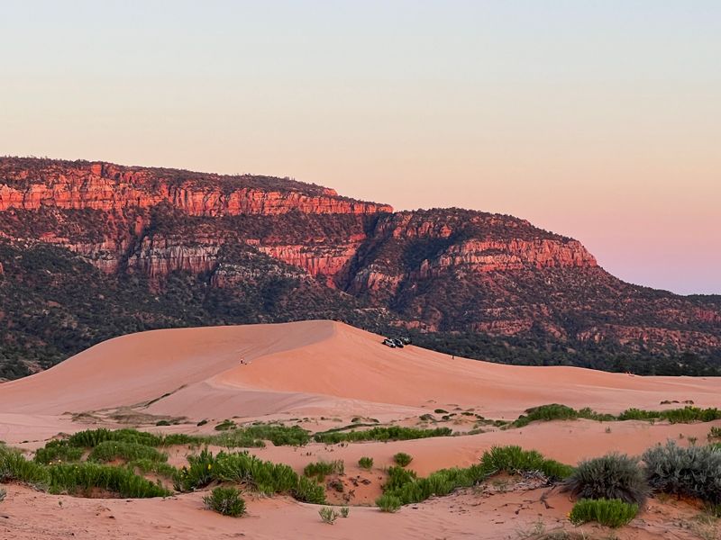
Coral Pink Sand Dunes State Park sits just over the Arizona border and delivers uniquely colored sand that glows at golden hour.
The hue comes from eroded Navajo sandstone and makes ridgelines photograph like a warm desert dream without heavy filters.
This is a split use park with areas for riding and zones reserved for hiking and photography, so follow signs to match your style.
Access is via County Road 43 near Kanab, UT 84741, where a small visitor area offers maps, rentals, and posted conditions for wind and closures.
Hikers can crest the main ridge in minutes, but lingering on the leeward face reveals smoother ripples that flow like silk.
Riders get long groomed climbs and soft catch basins that encourage confidence while still demanding smart throttle control.
Sunrise is cooler and gives strong texture for photos, while evening brings that coral pop that makes the park famous.
Permits are checked and rentals sell out on busy weekends, so booking early keeps the day simple and stress free.
Arizona visitors often use Page or Fredonia as base towns, then swing north for a half day loop with picnic time built in.
Sand temperature climbs fast by midday, so shoes with gaiters help keep feet happy during longer wanders across open slopes.
Bring a wide brim hat, water, and a lens cloth, because the fine grains sneak into every zipper and camera seam.
Wrap with a quick stop at the viewpoint deck to watch wind draw fresh lines while the sky fades to soft cloud pastel.
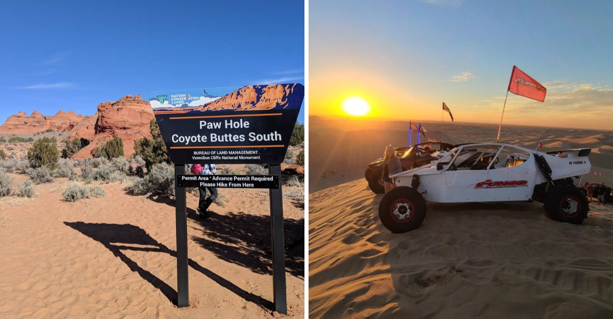
7. Coyote Buttes South
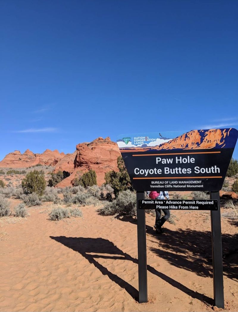
Coyote Buttes South is a permit area known for wild sandstone textures with sandy corridors that weave between domes and fins.
The terrain is not classic open dunes, yet the sand underfoot is constant and gives every step a soft crunch that slows the pace.
Photography is the draw here, with wind lines that run across orange slabs and sandy bowls tucked below striped alcoves.
Permits and trip planning support are managed through the Bureau of Land Management office at 4001 E. Aviator Drive, St. George, UT 84790.
High clearance is recommended, and drivers should lower tire pressures for rutted sand tracks that lead to the remote trailheads.
Navigation is visual and map based, so download layers and confirm waypoints since the landforms can scramble your sense of scale.
Arizona travelers often stage from Page, which keeps drive times reasonable and provides fuel, lodging, and last minute gear.
Plan for variable wind that can sandblast camera glass and paint new ripples in minutes after a gust front passes.
Hike softly on crusted patches and avoid delicate cross bedding where footprints linger far longer than you think.
Guides can help unlock lesser known angles and safe routes that string together the best formations without backtracking.
Carry extra water, a broad hat, and seasonal layers, because shade is scarce and spring sun reflects off bright sand.
Permits are competitive, so set alerts, read rules closely, and keep flexible dates to land this unforgettable outing.
8. Sand Tanks Wilderness
Sand Tanks Wilderness sits within the southern portion of Sonoran Desert National Monument and features sandy washes framed by rugged peaks.
It is remote and beautiful, but access is complicated by military range boundaries and permit requirements that you must handle in advance.
The sand here runs in long drainages rather than classic bowls, which makes it a great place to hike and learn wash reading skills.
Visitors often secure a Barry M. Goldwater Range permit for lawful travel near restricted zones south of Interstate 8 between Gila Bend and Ajo.
Roads vary from firm gravel to deep sand, so high clearance and aired down tires are smart for both traction and comfort.
Expect minimal signage, few people, and big sky silence that rewards careful planning and conservative decision making.
Hikers can follow sandy arroyos toward low passes where saguaro stands give shade patches and hawks circle on thermals.
Carry paper maps and downloaded layers because reception is spotty, and storms can rearrange crossings during monsoon bursts.
Arizona desert rules apply in full, including extra water, sun protection, and a realistic turnaround time that keeps the day safe.
Leave no trace principles are vital since cryptobiotic soil and fragile wash banks take time to recover from footprints.
Photography rewards patience as evening light grazes ripple lines and paints the mountains with soft purples and orange.
Build weather buffers and stick to open routes, and you will enjoy a wild slice of desert that feels far from the highway.
9. Safford Field Office Access Point
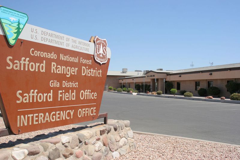
This entry focuses on the practical gateway for Hot Well Dunes information, which is the Bureau of Land Management Safford Field Office.
You can stop for travel guidance, current road conditions, and updates on seasonal restrictions that affect camping and fire use near the dunes.
The staff helps with maps, recreation permits, and advice on vehicle needs so you can match your plan to real time conditions.
The confirmed office location is 711 14th Ave, Safford, AZ 85546, which sits in town with easy access to fuel and supplies.
Visiting first saves time because you can confirm which spurs are graded, which tubs are open, and whether monsoon washouts changed routes.
It is also the place to verify closures that protect sensitive habitat when water levels rise or resource work is underway.
Arizona travelers appreciate the straight talk on weather windows and the best times to ride or hike with manageable temperatures.
Pick up hard copy maps as a backup since cell service fades as you head toward the open desert east of town.
Staff can share etiquette pointers that keep the area friendly, like speed control near camps and crest scanning to avoid blind surprises.
Ask about dispersed camping rules so your setup is compliant and your fire plan respects current conditions.
With solid intel in hand, the drive out feels less guessy, and you can spend more time in the sand and less time rerouting.
It is a low stress stop that adds clarity and confidence to a day built around dunes, hot water, and quiet desert space.
10. Gecko Road Staging Area Insight

Gecko Road is the prime staging corridor for the Imperial Sand Dunes, and it makes arriving from Arizona straightforward and quick.
The corridor rolls along the edge of giant dunes with wide pads, clear signs, and access to the Cahuilla Ranger Station for permits.
It is ideal for first timers because you can see the terrain before committing, then choose a pad that matches your comfort level.
The Cahuilla Ranger Station is along Gecko Rd, Brawley, CA 92227, where staff share safety updates, wind advisories, and route notes.
Flag requirements, whip height, and sound rules are posted, and compliance checks are common on busy weekends.
Early arrivals snag smoother entry and better parking angles, which keeps rigs organized and lines of sight clean for departure.
Walk the first dune crest on foot to gauge softness and find a safe slot before you roll machines into steeper bowls.
Keep radios charged and set regroup points so your crew can reconnect if ridge lines block views during long runs.
The afternoon wind usually builds from the west, which stacks lip edges and sends grit into paddles and chains.
Pack extra goggles, a face buff, and a spare flag mount, then stash tools where you can reach them without unpacking the whole rig.
Arizona day users often base in Yuma for a short pre dawn drive that lands them at the pads with cool air and empty lines.
With a smart approach, Gecko Road turns a big dunes day into a smooth, fun session with clear steps from arrival to last lap.
Dear Reader: This page may contain affiliate links which may earn a commission if you click through and make a purchase. Our independent journalism is not influenced by any advertiser or commercial initiative unless it is clearly marked as sponsored content. As travel products change, please be sure to reconfirm all details and stay up to date with current events to ensure a safe and successful trip.