Most people don’t realize how much Arkansas can pack into a single hike until they’re standing on a bluff one hour and heading toward a cave mouth the next.
The scenery flips fast, and the variety is the point.
If you want clear directions, real trail intel, and views that truly earn a spot on your shortlist, you’re in the right place.
I’ve walked these routes enough to know where the standout overlooks are, where the quieter corners hide, and where the smart turnarounds save your legs without wasting the day.
No fluff and no guessing, just trails that deliver.
Ready to plan a trip that proves why Arkansas keeps hikers coming back for more?
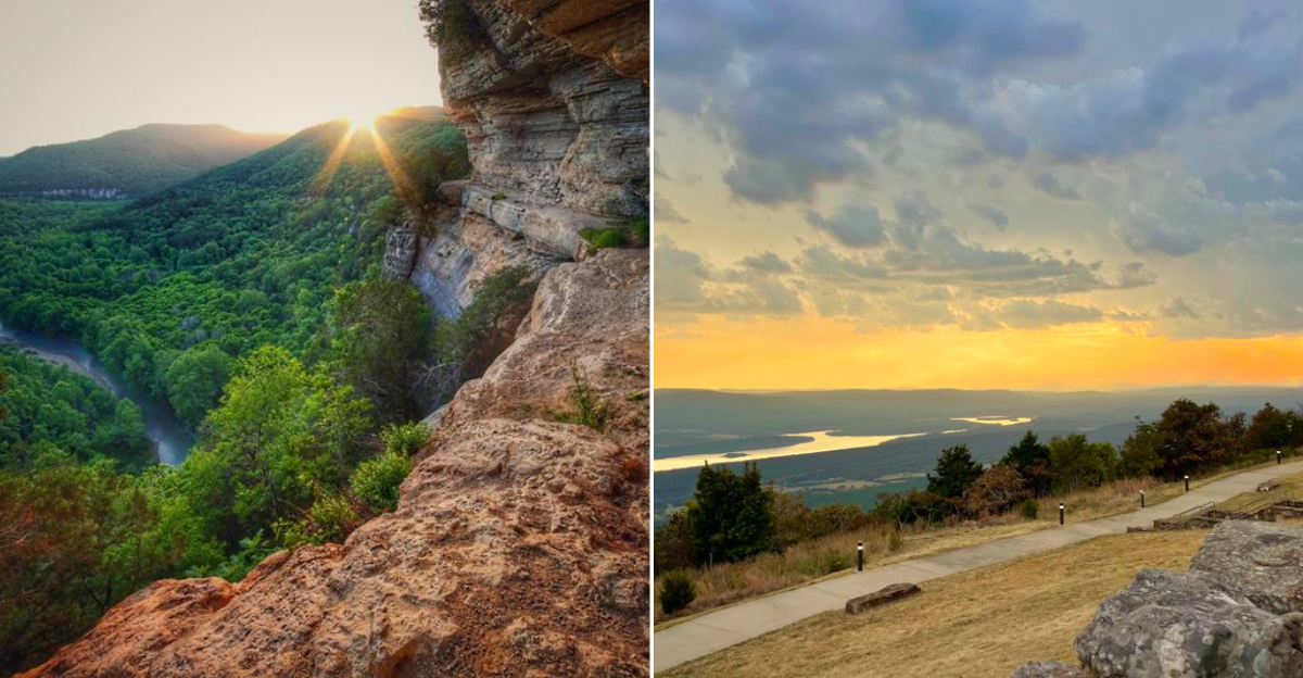
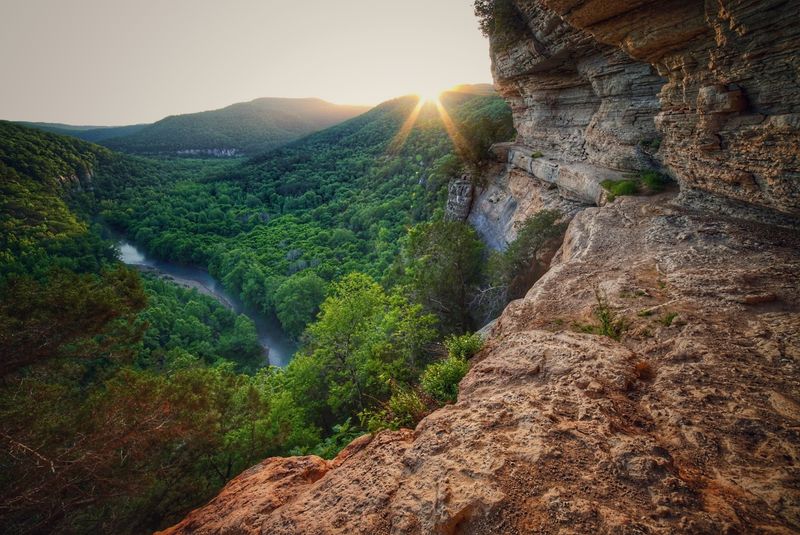
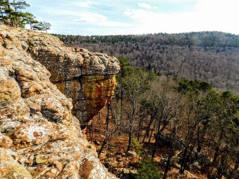
1. Whitaker Point Trail Big Bluff Views
Ever hike to a spot you’ve seen all over the internet and still stop in your tracks when you reach it?
Whitaker Point’s rock ledge juts over a deep Ozark valley, and it’s one of Arkansas’s cleanest overlooks for a quiet sit and a careful photo.
The trail rolls through hardwoods with a few rocky patches, then opens to the sandstone “beak” that frames sky and forest in one sharp glance.
On busy days, patience pays off.
Give people space, wait your turn, and you’ll get a better angle without the stress.
The grade stays friendly, but it still feels remote enough to shake off noise.
Spring brings small blooms along the path.
In colder months, leafless trees sharpen the view and make the valley feel even bigger.
I like arriving early because the light is softer and it’s easier to move around the ledge.
Navigation is straightforward, but watch roots and slick rock after rain.
Parking sits along County Road 5, and the forest path is clear as it branches toward the bluff.
Keep kids close near the edge and stay back from overhangs that can crumble after freeze-thaw cycles.
This overlook is the kind you’ll bring up the next time someone asks where to hike in Arkansas.
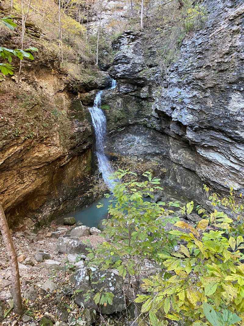
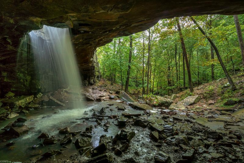
2. Lost Valley Trail Caves And Falls
How about a trail where something new shows up every few minutes?
Lost Valley packs a lot into a short out-and-back, with bluffs, a clear creek, and a waterfall that feels like a real payoff.
The walk starts mellow under tall trees, then follows Clark Creek as the canyon narrows and the air cools down.
Kids go straight for the stepping stones.
Adults usually appreciate how quickly it starts feeling like a little adventure.
The main highlight is Eden Falls, where water slides off a shelf into a small pool framed by moss and layered rock.
Just upstream, Eden Falls Cave adds a quick side mission.
A short crawl leads to a hidden falls, so bring a headlamp and keep your movements slow and careful.
I always pause at the entrance to check the flow and decide if today is a cave day or an outside-only day.
Weekends can get busy, but you can still find quiet if you linger near side alcoves and look up at the overhangs.
After rain, the sound gets louder and the creek braids around gravel bars that shift with the season.
The gravel access road ends at Lost Valley Trailhead, 5539 AR 43, Ponca, Arkansas.
Facilities are basic, signage is clear, and the route stays easy to follow.
Watch for slick limestone, and save a minute on the way back for one last look down the green corridor.
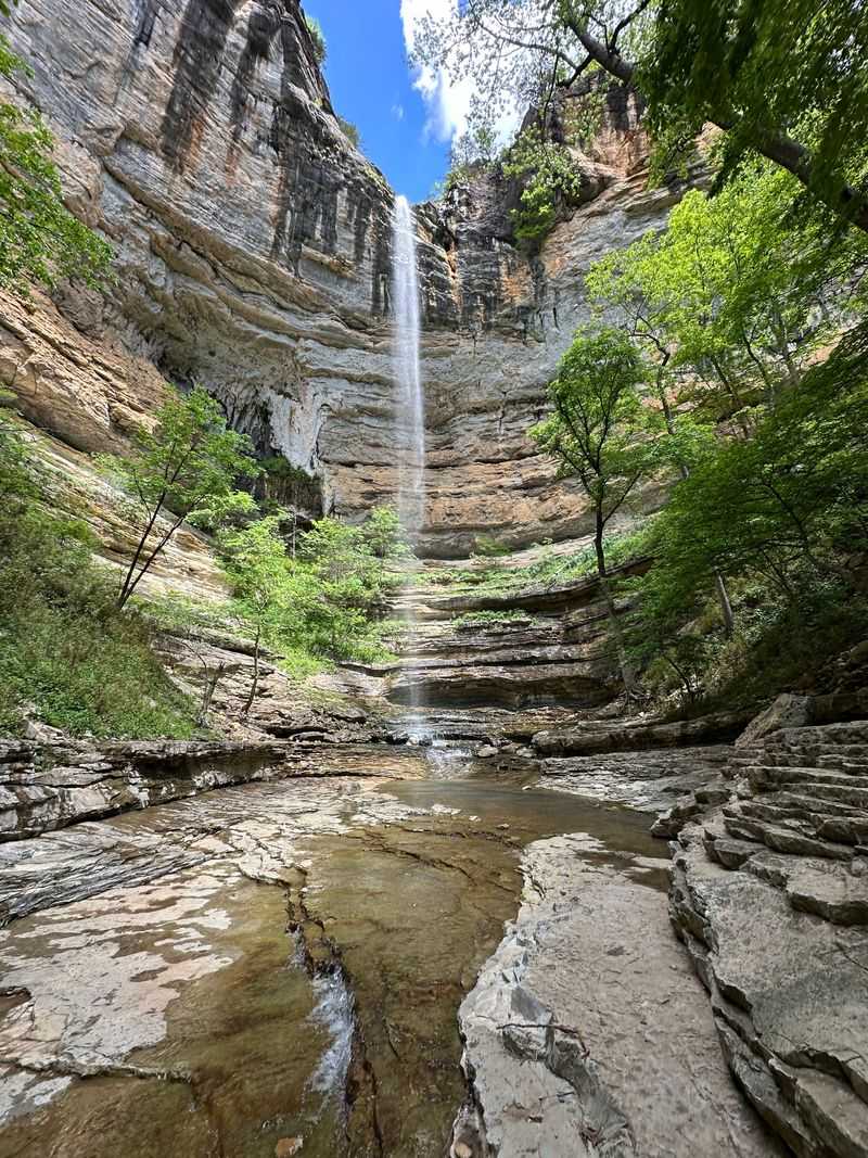
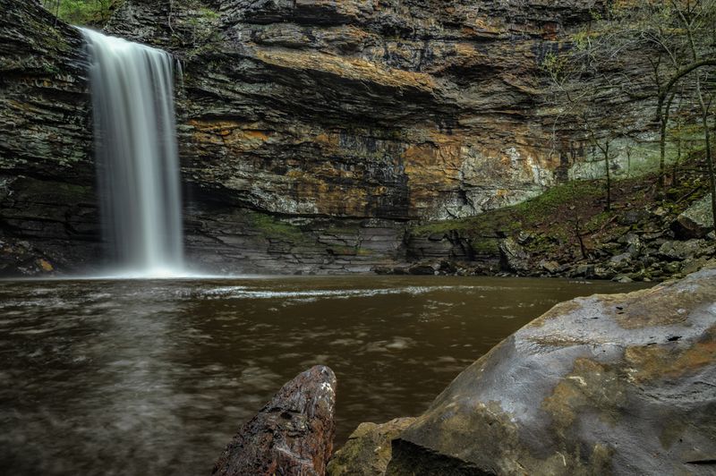
3. Hemmed In Hollow All Day Descent
Do you need a hike that feels like you’re dropping into a hidden room of the Ozarks?
Hemmed-In-Hollow is that kind of place, a sustained descent through hardwoods that ends at a towering waterfall in a natural amphitheater.
The canyon tightens as you go. Sound changes. Light shifts.
The air cools near the base as mist hangs in the shade and settles on dark stone.
This is a commitment hike, so pace your knees on the way down and save energy for the climb out.
In dry stretches the falls can shrink.
After rain, the chute gets loud and the spray fills the whole bowl.
I bring poles here because the return climb is steady, and the footing can change after storms.
You’ll catch glimpses toward Buffalo River country through the trees.
Down on the canyon floor, boulders and scattered logs add texture and make the place feel wild, not manicured.
Expect switchbacks, some mud, and a few narrow cuts that keep your attention on your steps.
If you like payoffs that make a day feel earned, this one hits.
Access begins from the Hemmed-In-Hollow Trailhead near Compton, Arkansas, above the Buffalo National Take breaks in shade, watch for loose rock, and keep an eye on daylight for the climb back.
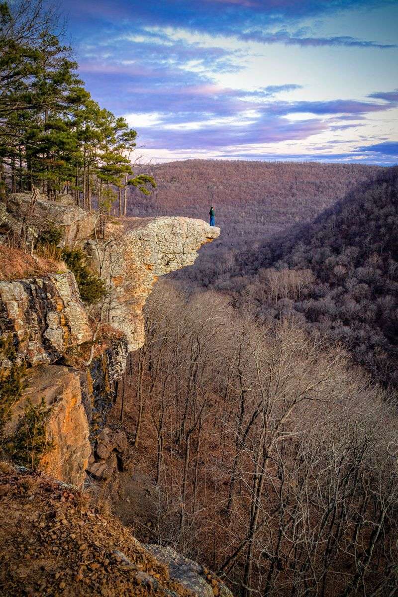
4. Goat Trail To Big Bluff Balcony
If you’re even a little nervous around drop-offs, the Goat Trail to Big Bluff will get your attention fast.
This route gives you a true balcony walk high above a wide bend of the Buffalo River.
Some stretches feel comfortably wide. Others narrow just enough that slow steps and a calm head are non-negotiable.
The views sweep across blue water and green ridges, laid out like a living map.
The spur breaks off the Centerpoint Trail, so the approach starts in the woods before the cliff zone suddenly opens.
I noticed I always pause at the junction, take a snack break, and reset my breathing before that final exposed stretch.
If heights unsettle you, turn around anytime.
Wind can kick along the face, and good grip matters on broken rock.
When the ledge tightens, keep conversations short and your attention on your feet.
For photos, pick a seated spot and let the view come to you instead of leaning for it.
If you want an unforgettable overlook without an all-day summit grind, this hike hits the sweet spot.
The best way is to start at Centerpoint Trailhead at 6523 AR 43, Ponca, Arkansas, and follow signs toward Big Bluff via the Goat Trail spur.
The return climbs steadily, so save energy for the push back to the rim.
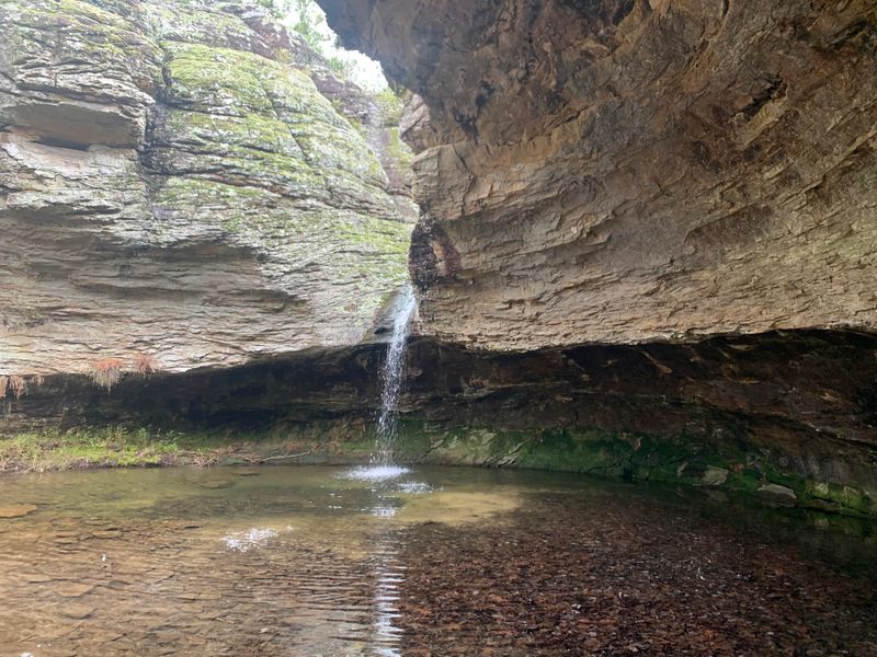
5. Glory Hole Falls Short Surprise Hike
I showed up at Glory Hole Falls expecting a cute little “internet hike”, and then I just stood there like: “Okay… How is the water doing that?”.
The stream slips through a round opening in sandstone and drops into a shaded grotto, and it photographs well from both above and below.
The approach stays simple at first, then tilts downhill toward the drainage.
In wet seasons the pour is loud and lively.
In drier stretches, the “hole” becomes a sculpted frame for sky and rock, which is still worth the walk.
I like circling the bowl clockwise to compare angles, then climbing back up to view the lip from the flat rock above.
Watch your footing, because the slab around the opening can stay slick even when the creek looks calm.
This spot gets talked about for a reason, but it still feels tucked away compared to the big-name overlooks.
Travel light, bring traction if it rained recently, and keep a respectful distance from the edge.
If you thought novelty hikes were gimmicks, this one wins on real geology.
Trail access sits along AR 16 and AR 21 near Nail, Arkansas, with a pullout commonly used by hikers.
Follow the informal path down the drainage and stick to the obvious tread through forest and rock.
It’s a compact, surprising stop that pairs easily with other nearby trails.
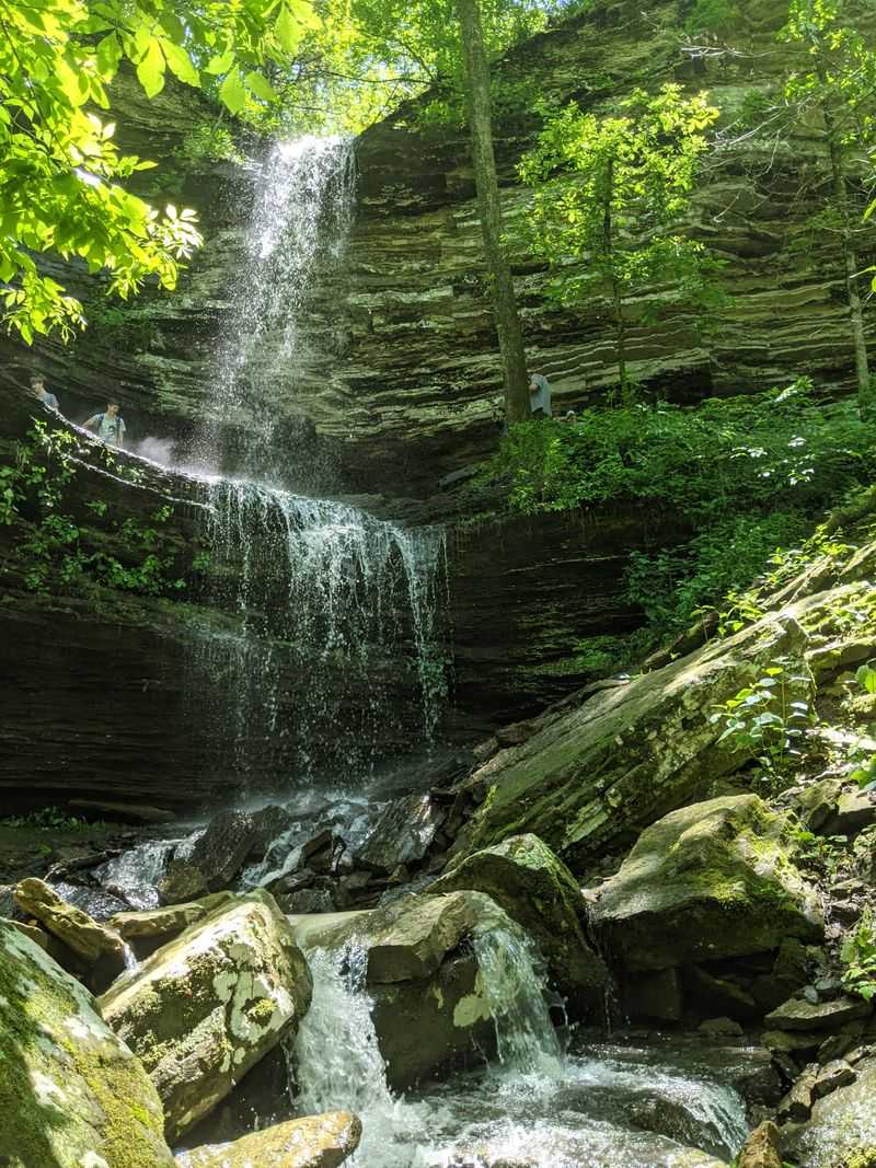
6. Cedar Falls Trail Petit Jean Classic
Did you know you can get a waterfall hike that feels well-run without feeling “theme-park” about it?
Cedar Falls at Petit Jean hits that sweet spot, with a canyon walk that ends at a tall, steady cascade.
The route starts near the lodge area, then drops through switchbacks into a cool corridor lined with massive boulders.
You’ll hear the water before you see it.
That sound pulls you forward until the falls finally open up into a broad pool.
I like how the trail keeps a steady grade without long rough patches, so you can actually enjoy the scenery while you move.
The canyon walls show clean layers that change color as the light shifts.
After rain, mist can hang in the air and make the whole place feel extra fresh.
Take creek crossings seriously. Flat stones get slick fast from spray, even when the water looks calm.
If you want to pair the hike with a picnic or a quick viewpoint at sunset, the park layout makes planning simple.
This is one of my go-to Arkansas picks for first-timers, because the signage is clear and the payoff is dependable.
For this one, you want to begin at Cedar Falls Trailhead at 1285 Petit Jean Mountain Rd, Morrilton, Arkansas, and follow the signed path into the canyon.
Facilities are close by, and the climb back is moderate but steady.
You get a full-value waterfall without spending all day, which leaves room to explore more of the mountain.
7. Seven Hollows Trail Rock Tunnel Magic
After the big waterfall payoff at Cedar Falls, Seven Hollows is the fun switch-up that keeps you exploring.
It feels like a scavenger hunt loop, stringing together arches, a small natural tunnel, and pocket canyons without a long grind.
The route moves from open pine into shaded hollows where water has shaped sandstone into ledges, shallow caves, and little surprise corners.
The grotto area is a standout, especially after rain when small trickles run down the walls and the air feels cooler.
I love the short tunnel because it adds variety without turning the hike into a scramble.
If the light is low, a headlamp helps, but most of the passage stays bright enough for careful steps.
Even on busier days, you can usually find a quiet pocket to sit, listen, and let the place feel bigger than it looks on the map.
Wayfinding is solid with blazes, though roots and occasional mud patches keep you paying attention.
If you want a hike that drops features at a steady pace, this one keeps your interest start to finish.
This journey begins at Seven Hollows Trailhead in Petit Jean State Park at 1285 Petit Jean Mountain Rd, Morrilton, Arkansas.
Facilities are back near the main park areas, and a visitor center map adds helpful context.
It’s shade, stone, and short diversions, all stacked into one Arkansas loop.
8. Signal Hill Trail Arkansas High Point
Want to say you hit the highest point in Arkansas without earning it the hard way?
Signal Hill is your move, with a mellow loop through quiet woods and no big mountain push.
The official marker sits in a small clearing with benches, so it’s easy to rest, snap a photo, and enjoy the little victory.
You won’t get a sweeping vista at the marker itself.
Still, the satisfaction of tagging the state high point lands.
The trail surface stays friendly, which makes this a great add-on after the overlooks along the rim.
Try starting near the lodge and linking paths so one day includes both forest shade and cliffside views.
Signage is clear, and the trail network makes sense after a quick look at the map.
Wind can be brisk out on the rim, then calm under the canopy, so layers help if you’re bouncing between both.
Have you ever enjoyed a quiet “summit” more than a crowded overlook?
This one fits that mood when you want a calm checkpoint and a short, satisfying stroll.
Starting point: Signal Hill Trailhead in Mount Magazine State Park at 16878 AR 309, Paris, Arkansas.
Follow the marked paths to the clearing, then loop back at whatever pace feels right.
You’ll leave with a small achievement and still have time to chase another Arkansas view before sunset.
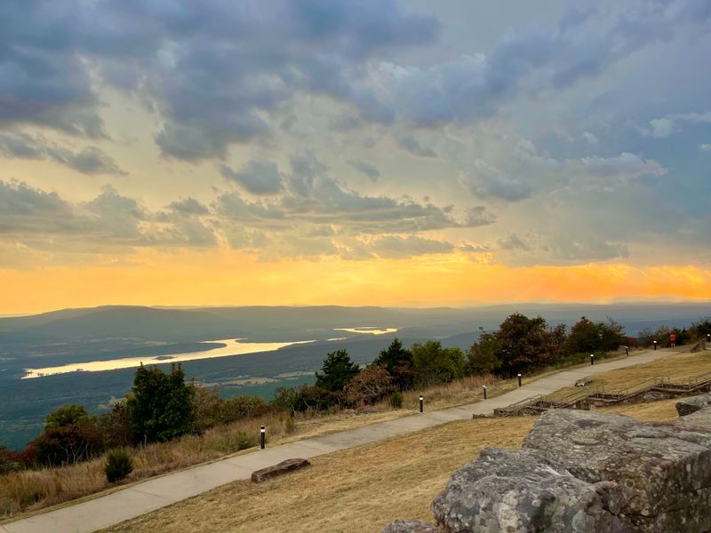
9. Mount Nebo Rim Trail Endless Overlooks
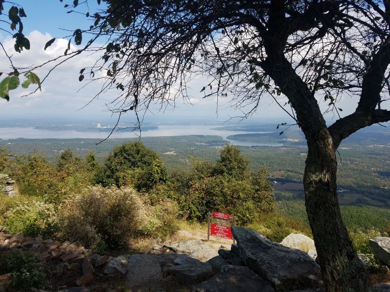
If you’re in the mood to collect views without grinding up a summit, Mount Nebo’s Rim Trail is perfect.
It strings overlooks around a tidy loop, with frequent places to sit and reset.
Stone walls and natural ledges frame the Arkansas River Valley, and the light can change fast when clouds slide through.
Pick a direction and let the trail do the work.
Every gap in the trees feels like a new angle worth stopping for.
I like this route for casual hiking with friends because the grade stays moderate and the payoff repeats often.
Sunrise and sunset give totally different vibes, and there’s enough space to spread out without losing the group.
The park’s small footprint also makes it easy to link segments with short road walks if you want to mix it up.
In a few sections you’ll share the corridor with bikes and runners, so step aside and keep the flow smooth.
Want a lunch break with a view?
Plenty of pullouts have benches or low walls that are actually comfortable.
The scenery stays consistent, which makes this a reliable pick when everyone’s energy level is a little different.
Hikers meet at Rim Trail access near 16728 State Hwy 155, Dardanelle, Arkansas, and follow signs around the mountain.
Facilities are near the visitor center and campsites, which makes water planning simple.
Expect clean air, big valley views, and a rhythm that basically dares you to linger at every overlook.
10. Yellow Rock Trail Devil’s Den Panorama
After a few shaded miles at Devil’s Den, Yellow Rock is the moment where the park suddenly opens up.
The loop starts in the trees and ends on a big stage, with a balcony view that sums up the landscape in one sweep.
You climb gently through oak and cedar, then pop out at a limestone ledge with a low wall.
The valley spreads wide, and the ridgelines stack up under a big sky.
This is a great spot to sit and watch shadows move across the folds of land.
It’s also a fun place to compare seasons, because fall color and spring greens both show off here.
The best way to do it is as an afternoon hike.
The light stays softer across the valley, and the return walk feels easier on your legs.
The trail surface is mostly stable, with a few rocky bits that keep you paying attention without slowing you down.
Families come for the overlook, and solo hikers get enough quiet to decompress without committing to a huge day.
If you’re collecting classic Arkansas viewpoints, put this one near the top.
The modest effort-to-payoff ratio is hard to beat.
You want to start at Yellow Rock Trailhead in Devil’s Den State Park at 11333 West AR 74, West Fork, Arkansas.
Follow the marked loop to the overlook, then continue back through the shaded sections to close the circle.
You’ll leave with a photo that basically explains the park, and a better sense of how the ridges and valleys fit together.
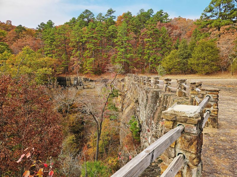
11. Pedestal Rocks Loop Stone Tower Views
After a few classic overlooks, Pedestal Rocks feels like the Ozarks decided to get weird in the best way.
This trail tours stone columns and narrow fins that look hand-carved, set right along a bluff edge with long views beyond.
Each spur leads to another vantage point, and the steady variety makes the loop feel longer in a good way.
It works best when moving slowly and comparing the rock profiles from different angles.
Perspective changes everything, so one tower looks tall and isolated, then two steps later it looks like part of a whole lineup.
Wind can be strong along the rim, so stay back from edges and pick seated spots for photos.
The ground gets uneven too.
Leaf cover can hide holes and cracks between rocks, so watch where you plant your feet.
This area pairs perfectly with nearby Kings Bluff, which adds a straight ledge and a seasonal waterfall.
Together they make an easy full-day plan without repeating the same scenery.
If you want a signature Arkansas bluff walk, this combo wins on geology and views.
The forest sections between features are pleasant, and the final overlook usually earns the longest pause.
For a good starting point, go to Pedestal Rocks Trailhead on AR 16 near Pelsor, Arkansas, in the Ozark National Forest.
Signs mark the loop, but facilities are limited, so bring water and give yourself time.
12. Sam’s Throne Trail Ozark Overlook Favorite
Want a bluff walk where one big landmark steals the whole show?
Sam’s Throne is that spot, with a rounded sandstone dome sitting like a stage in the middle of sweeping Ozark views.
The approach rolls through the woods, then a short climb brings you to an open rim with room to wander and choose your own angle.
It’s a “meet me here” kind of place.
Climbers and hikers come back for the light, the space, and the way the landscape feels wide without feeling chaotic.
Wind can move straight across the gap, so a light layer is smart if you plan to sit for a while.
The tread gets rocky and uneven in sections, which means you’ll want steady steps near the edge.
Sunset is the star here.
The dome catches warm color and the surrounding hills glow, but midday can still be great for wandering and finding quieter corners away from the main pullout.
If you like Arkansas scenery that feels open and centered at the same time, this hits that balance.
From Sam’s Throne Trailhead on AR 123 near Mount Judea, Arkansas follow the clear path toward the rim.
Facilities are minimal, so bring water and a simple map for the use paths.
If you’re ending your trip here, give it one last slow look and let that wide Ozark horizon be the thing you take home.
Dear Reader: This page may contain affiliate links which may earn a commission if you click through and make a purchase. Our independent journalism is not influenced by any advertiser or commercial initiative unless it is clearly marked as sponsored content. As travel products change, please be sure to reconfirm all details and stay up to date with current events to ensure a safe and successful trip.