You look up and see 133 steps. That is not so bad, right?
About halfway up your legs will start to question your life choices. But do not stop.
At the top of this fire tower, West Virginia unfolds beneath you like a giant green quilt stitched with rivers and ridges.
The breeze hits your face first. Then the silence. Then the view that goes on forever.
Former fire lookouts once scanned these horizons for smoke, but all you will find is pure beauty.
Have you ever stood somewhere that made you feel small in the best possible way?
This is that place. The climb takes five minutes.
The memory stays for a lifetime. Just bring water and a camera.
Your legs will thank you later. The view will leave you speechless.
The History Behind the Tower

West Virginia has a way of hiding its most remarkable stories deep in the forest, and this tower is proof of that. The original fire tower on this site was built back in 1922, making it the first of its kind in the entire state.
That alone gives the place a weight that you feel before you even start climbing.
The current steel structure replaced the original in 1963 and was named after Ernst B. Olson, a fire control assistant who dedicated 28 years of service to the Monongahela National Forest.
That kind of commitment deserves more than a plaque. Naming a tower after someone feels fitting when the tower itself has outlasted so many things around it.
Standing at the base and looking up, it is easy to forget you are looking at something nearly 100 feet tall. The history packed into this steel frame makes every step feel like a small tribute to the people who protected these forests for generations.
Getting There on Forest Road 717

Forest Road 717 is the kind of road that makes you slow down whether you want to or not. It is a gravel path that branches off from U.S.
Route 219, and while a regular passenger car can handle it just fine, those last two miles have a way of reminding you that you are definitely not in the city anymore.
The road is closed during winter months, so planning ahead matters. The tower is generally open from mid-April through December, which gives you a solid window across three distinct seasons to make the trip happen.
Spring and fall are especially popular for good reason.
Pulling up to the small parking area near the tower, you get your first real look at the structure rising above the canopy. There is something almost theatrical about that first glimpse through the trees.
A small picnic area sits nearby, which makes the whole spot feel like a proper destination rather than just a quick stop along the way.
What 133 Steps Actually Feels Like

Let me be honest with you: 133 steps sounds manageable until you are about halfway up and realize the ground is already very, very far below. The steel steps are open-grated, which means you can see straight down with every single footfall.
For some people, that is thrilling. For others, it is a personal challenge they did not expect to sign up for.
The good news is that the railing is well-maintained, with a lower handrail available for shorter climbers too. The structure itself is sturdy, regularly inspected, and built to handle the kind of wind that rolls across Backbone Mountain.
You might feel the tower sway slightly in a strong breeze, and that is completely normal.
Taking breaks on the way up is perfectly acceptable. Pausing to look out at the trees below at different heights actually adds to the experience rather than taking away from it.
By the time you reach the top walkway just below the cab, every single step will have been worth it.
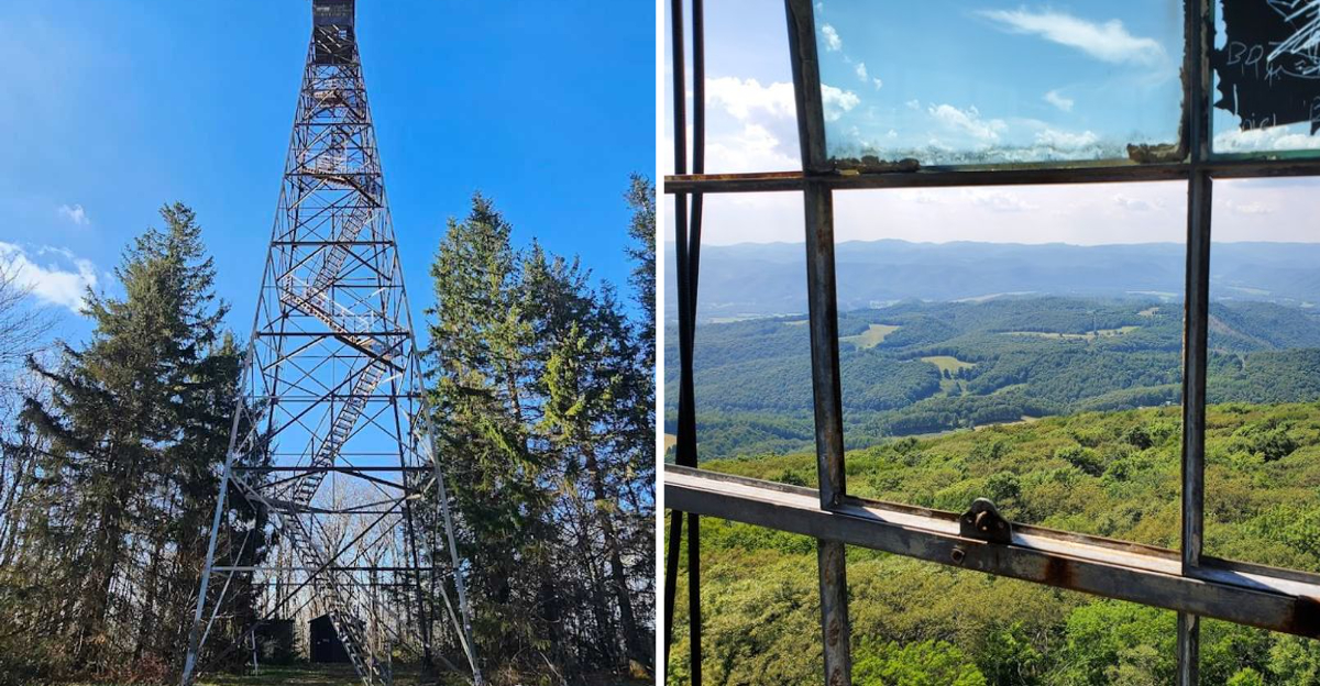
The 360-Degree Panoramic Views

Nothing really prepares you for the moment the view opens up completely. Standing on the walkway near the top of the Olson Observation Tower, you can see the Cheat River watershed, the town of Parsons, Blackwater Canyon, Canaan Mountain, and Backbone Mountain all at once.
It is the kind of view that makes you reach for your phone and then realize no photo will ever fully capture it.
On clear days, Fernow Experimental Forest, Blackwater Falls State Park, and the Canaan Valley National Wildlife Refuge are all visible from up there. The sheer range of what you can see in a single slow turn is genuinely staggering.
Mountains layer upon mountains in every direction, each ridge slightly different in color and texture.
Summer brings a lush, deep green that feels almost surreal from that height. The tower sits at roughly 3,736 feet above sea level, which means the air up top carries a crispness that makes breathing feel like a small reward all on its own.
Hiking Trails That Lead to the Tower

For anyone who wants to earn the view with their legs rather than their car, there are several trail options worth knowing about. The Canyon Rim Trail is a 3-mile route that brings you to the tower through some genuinely beautiful forest terrain.
It is a solid choice if you want a taste of the backcountry without committing to a full day.
The Blackwater Canyon Rail Trail stretches 10.5 miles and offers a longer, more immersive experience through one of West Virginia’s most dramatic landscapes.
Then there is the Allegheny Trail, a 311-mile long-distance route that passes through this area, connecting the tower to a much bigger network of wild places.
Whichever trail you choose, expect some uphill sections and plan accordingly with water and snacks. Cell service is limited on most of these routes, so downloading offline maps beforehand is a smart move.
The trails reward patience, and the little surprises along the way, like hidden overlooks and creek crossings, make the journey feel as worthwhile as the destination.
What to Pack for Your Visit

Packing smart for this trip makes a real difference in how much you enjoy it. Water is non-negotiable, especially if you are hiking in rather than driving.
The climb itself is not strenuous by hiking standards, but the wind at the top can dehydrate you faster than you expect, particularly in summer.
Wearing layers is a genuinely good idea at any time of year. The temperature at 3,736 feet can be noticeably cooler than in the valley, and the wind near the top of the tower adds a chill factor that catches people off guard.
A light jacket stuffed into a day pack takes up almost no space and earns its keep quickly.
Bringing snacks to enjoy at the picnic area near the base of the tower turns the visit into a proper outing rather than a quick stop. Trail mix, fresh fruit, sandwiches, and granola bars all travel well and taste significantly better when eaten surrounded by mountain air and forest quiet.
Good shoes with grip matter on the steel steps, especially if there is any moisture in the air.
Sunrise and Sunset at the Tower

Timing your visit around sunrise or sunset takes an already remarkable experience and pushes it into a completely different category.
The tower faces open sky in every direction, which means there are no obstructions between you and the full display of color that happens at the edges of the day.
Sunrise visits require an early start and a willingness to navigate Forest Road 717 in low light, but the reward is a sky that shifts from deep blue to pink to blazing gold while the forest below slowly wakes up.
It is genuinely one of the quieter, more personal ways to experience this place.
Sunset at the tower is slightly more accessible for most visitors since the road is easier to navigate in daylight. The light catches the ridgelines in a way that makes the whole landscape look like it is lit from within.
Standing just below the cab as the sun drops behind Backbone Mountain is the kind of moment that makes you want to come back every single season without exception.
The Picnic Area and Surrounding Atmosphere

Not every great destination needs a restaurant nearby to feel complete, and the Olson Observation Tower proves that point effortlessly.
The small picnic area at the base of the tower is simple, shaded, and perfectly placed for a proper outdoor meal before or after the climb.
Packing a lunch and spreading it out on one of the picnic tables with the tower rising above you and the forest pressing in from all sides is a genuinely satisfying experience.
The sounds are mostly wind through the trees, birds doing their thing, and the occasional creak of the steel structure in a breeze.
It is the kind of quiet that city people specifically travel to find.
The surrounding atmosphere of the Monongahela National Forest adds a depth to the visit that is hard to manufacture anywhere else. The air smells like pine and earth.
The light filters through the canopy in shifting patches. Sitting there with good food and no particular rush is one of the most underrated parts of the whole trip, honestly.
Planning Your Trip to the Olson Observation Tower

Getting the logistics right makes the difference between a smooth adventure and a frustrating one.
The tower is open Monday through Friday from 8 AM to 4:30 PM, which means weekend warriors need to plan around a weekday visit or check for any seasonal updates before heading out.
The road closes in winter, so the window runs from mid-April through December.
The drive to Forest Road 717 from Thomas takes roughly 15 to 20 minutes, making it a very manageable side trip if you are already exploring Tucker County.
Parking near the tower is limited to around six vehicles, so arriving earlier in the day is a smart way to avoid any crowding during peak season.
Cell service is surprisingly good at the very top of the tower, which makes sharing the view in real time entirely possible. The whole experience, from the gravel road to the top step, feels like a reward for showing up.
Come prepared, come curious, and leave plenty of time to just stand there and take it all in.
Address: Forest Rd 717, Hambleton, WV
Dear Reader: This page may contain affiliate links which may earn a commission if you click through and make a purchase. Our independent journalism is not influenced by any advertiser or commercial initiative unless it is clearly marked as sponsored content. As travel products change, please be sure to reconfirm all details and stay up to date with current events to ensure a safe and successful trip.