When most people think of New Jersey, they picture traffic on the Turnpike or funnel cakes on the boardwalk.
But here’s the twist, the Garden State is secretly sitting on a geological highlight reel that could make a national park jealous.
I’m talking waterfalls born from volcanic chaos, minerals that glow like they belong in a nightclub, and cliffs that have literally watched continents break up. (Yes, even rocks have seen more drama than your favorite reality show.)
Forget the stereotypes. New Jersey’s rocks are older than dinosaurs, its boulders balance like they’re auditioning for a circus act, and its neon-glowing minerals look like Mother Nature got a little carried away with the highlighters.
So here’s my challenge: let’s swap the mall trip for a hike. I promise your Instagram feed will thank you, and you’ll walk away with stories that make “I went to see rocks” sound way cooler than it has any right to.
1. Paterson Great Falls
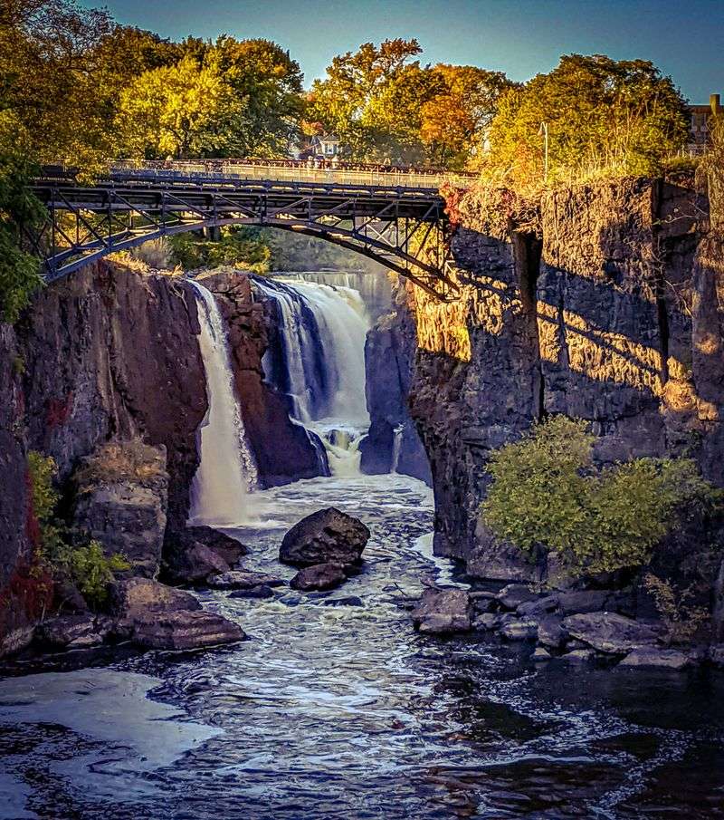
Picture a waterfall so powerful it once drove the entire American Industrial Revolution, and you’re looking at Paterson Great Falls. This 77-foot cascade thunders over ancient volcanic basalt rock that formed roughly 13,000 years ago when molten lava cooled and cracked into geometric columns.
The sheer force of the Passaic River plunging into the jagged gorge below creates a roar you can hear blocks away.
Walking along the viewing platforms at 72 McBride Ave, Paterson, NJ 07501, you’ll feel the mist on your face and witness geology in action as water continues to carve deeper into the dark rock. The basalt cliffs show off their hexagonal columns, a telltale sign of rapid cooling lava that geologists absolutely love to study.
Alexander Hamilton himself recognized the power potential here and helped establish America’s first planned industrial city around these falls.
Today, the falls sit within a National Historical Park where nature and history collide spectacularly. Spring runoff makes the falls especially dramatic, turning the cascade into a churning chocolate-brown torrent that showcases erosion’s raw power.
The surrounding park offers multiple viewpoints, each revealing different aspects of the geological formation.
Photographers flock here year-round because the contrast between urban Paterson and wild water creates stunning compositions. Educational signs explain how volcanic activity shaped this landscape long before humans arrived.
Whether you’re a rock enthusiast or just someone who appreciates nature’s raw power, standing before these falls connects you directly to volcanic forces that shaped New Jersey millions of years before the first dinosaur walked Earth.
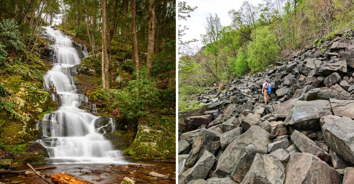
2. The Palisades Giant Stairs
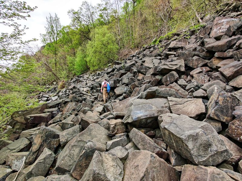
Standing at the base of the Palisades feels like facing a 500-foot wall built by giants, and in a way, that’s exactly what happened. These towering diabase cliffs formed 200 million years ago when magma pushed between existing rock layers as the supercontinent Pangaea began tearing itself apart.
The molten rock never reached the surface but cooled slowly underground, creating the dense, dark diabase that now dominates the western shore of the Hudson River.
The Giant Stairs trail at Palisades Interstate Park, Alpine, NJ 07620, takes you right up close to these geological monsters through a boulder field that resembles a titan’s staircase. Each massive rock step shows the characteristic vertical columns formed as the cooling magma contracted and fractured in predictable patterns.
Geologists travel from around the world to study these cliffs because they represent one of the clearest examples of igneous intrusion visible anywhere.
Hiking here means scrambling over house-sized boulders that broke away from the cliffs over millennia, a process still happening today. The trail challenges your legs and rewards you with stunning views of the Hudson River and Manhattan skyline beyond.
Native Americans called these cliffs “rocks that look like rows of trees” because of their distinctive columnar appearance.
George Washington used these cliffs as natural fortifications during the Revolutionary War, and their strategic importance stemmed directly from their geological impregnability. Modern rock climbers test their skills on these ancient walls, though strict regulations protect most sections.
Visiting the Palisades connects you to the exact moment when the Atlantic Ocean began forming and continents started their slow dance to their current positions.
3. Tripod Rock
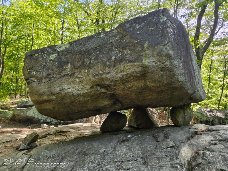
Balanced on three smaller stones like nature’s ultimate magic trick, Tripod Rock defies expectations and gravity simultaneously. This massive glacial erratic weighs approximately 160 tons yet perches delicately on three basketball-sized rocks at Pyramid Mountain, 127 Boonton Ave, Kinnelon, NJ 07405.
Glaciers carried this enormous boulder from somewhere north during the last ice age, then deposited it in this seemingly impossible position as the ice melted roughly 18,000 years ago.
The hike to reach Tripod Rock takes you through beautiful hardwood forest up moderate trails that reward your effort with one of geology’s most photogenic puzzles. Scientists still debate exactly how glacial processes created this perfect balance, though most agree that melting ice gently lowered the massive rock onto its three supports.
The boulder’s underside shows glacial scratches called striations, proof of its journey locked in ice.
Native American legends surround this rock, with some tribes believing it held spiritual significance or marked important astronomical alignments. Modern measurements show the rock does align with certain solar and lunar events, though whether this resulted from intention or coincidence remains hotly debated.
Nearby, you’ll find other glacial erratics scattered throughout the preserve, but none match Tripod Rock’s dramatic presentation.
Touching the massive boulder and feeling its stability despite the improbable setup creates an unforgettable connection to ice age forces. The surrounding Pyramid Mountain Natural Historic Area protects numerous other geological features including more balanced rocks and glacial formations.
Visiting during fall foliage season adds spectacular color to an already remarkable geological display that proves sometimes truth really is stranger than fiction.
4. Delaware Water Gap
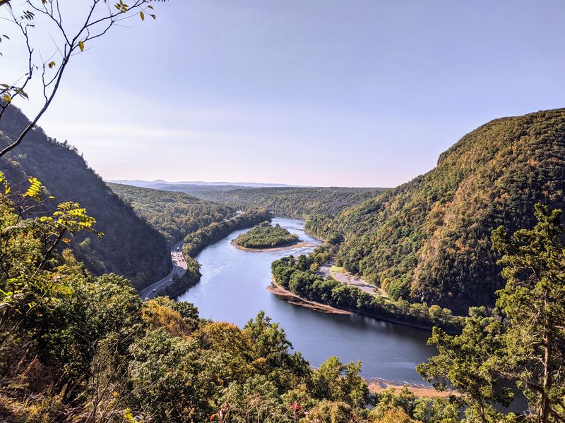
Where the Delaware River slices straight through the Kittatinny Ridge, you’ll find one of the eastern United States’ most dramatic geological features. Mount Tammany rises sharply on the New Jersey side near Hardwick, NJ 07825, off I-80, showcasing layers of ancient quartzite and sandstone tilted nearly vertical by mountain-building forces.
The gap itself represents millions of years of erosion as the river carved through rock that once stood as a continuous mountain barrier.
Hiking Mount Tammany’s trails takes you up steep switchbacks past exposed rock layers that read like pages in Earth’s history book. Each stratum represents a different ancient environment, from tropical seas to desert dunes, all compressed and folded by tectonic forces.
The summit rewards your climb with panoramic views across the gap where you can actually see how water wins the battle against rock given enough time.
Geologists debate whether the Delaware River carved this gap from scratch or followed a pre-existing weak zone in the rock, but either way, the result showcases erosion’s incredible power. The exposed rock faces display clear bedding planes, joints, and fractures that control how the mountain weathers and breaks apart.
Spring and fall bring the most dramatic views as water levels change and foliage either blooms or blazes with color.
The Appalachian Trail crosses through the gap, making this a bucket-list destination for hikers and geology enthusiasts alike. Educational programs at the nearby visitor center explain the complex forces that created this landscape.
Standing at the overlook, watching the river continue its ancient work of carving deeper into solid rock, you witness geology happening in real time at a scale that makes human lifespans feel like mere blinks.
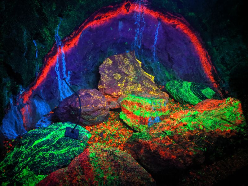
5. Franklin Mineral Museum Fluorescent Tunnel
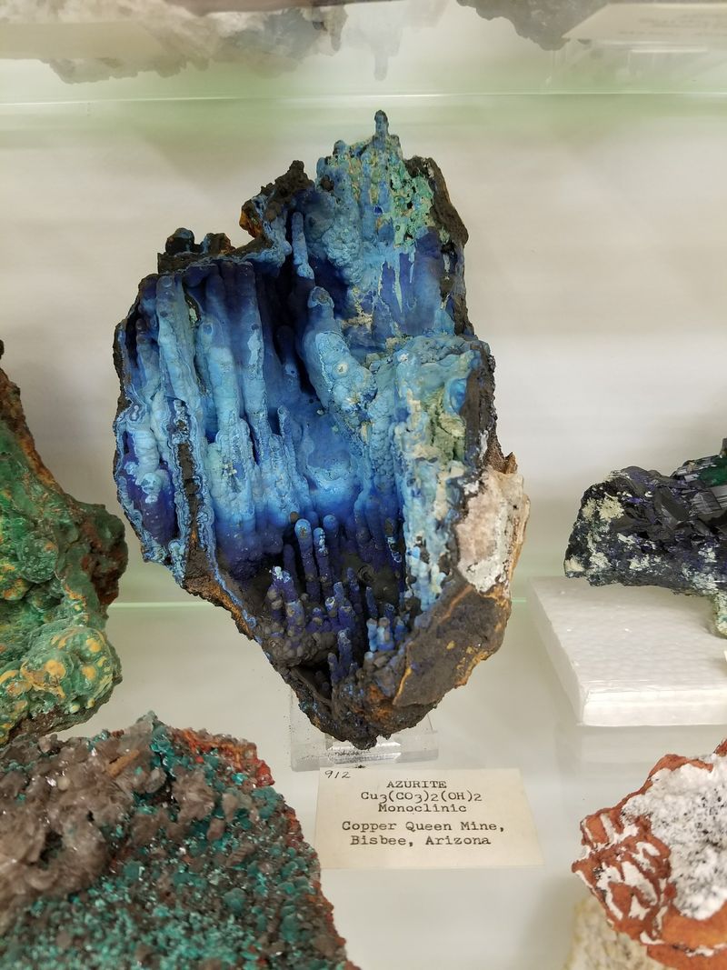
Step into darkness, flip a switch, and watch the walls explode into neon greens, blazing reds, and electric oranges that seem impossible in nature. The Franklin Mineral Museum at 32 Evans St, Franklin, NJ 07416, houses one of Earth’s most spectacular geological oddities in its famous fluorescent tunnel.
This former zinc mine contains more unique mineral species than anywhere else on the planet, and many of them glow like alien landscapes under ultraviolet light.
Walking through the tunnel under normal light shows ordinary-looking rock walls, but when UV lamps illuminate the space, you’re suddenly inside a psychedelic wonderland. Minerals like willemite glow bright green, calcite shines red, and dozens of other rare compounds create a natural light show that rivals any art installation.
Scientists have identified over 350 different mineral species in Franklin, with roughly 90 found nowhere else on Earth.
The museum explains how this incredible diversity resulted from unique geological conditions 1.1 billion years ago when zinc-rich fluids circulated through limestone, creating an unprecedented chemical cocktail. Kids absolutely love the glowing rocks, but adult rock hounds often spend hours examining the specimens and learning about fluorescence.
The gift shop sells UV flashlights so you can hunt for fluorescent minerals in the outdoor collecting area.
Educational programs teach visitors how fluorescence works and why certain minerals glow specific colors under ultraviolet radiation. The tunnel stays cool year-round, making it a perfect summer escape that also happens to showcase geological phenomena found almost nowhere else.
Photographers struggle to capture the intensity of the colors, meaning you really need to experience this glowing underground world in person to believe it exists in New Jersey.
6. High Point State Park
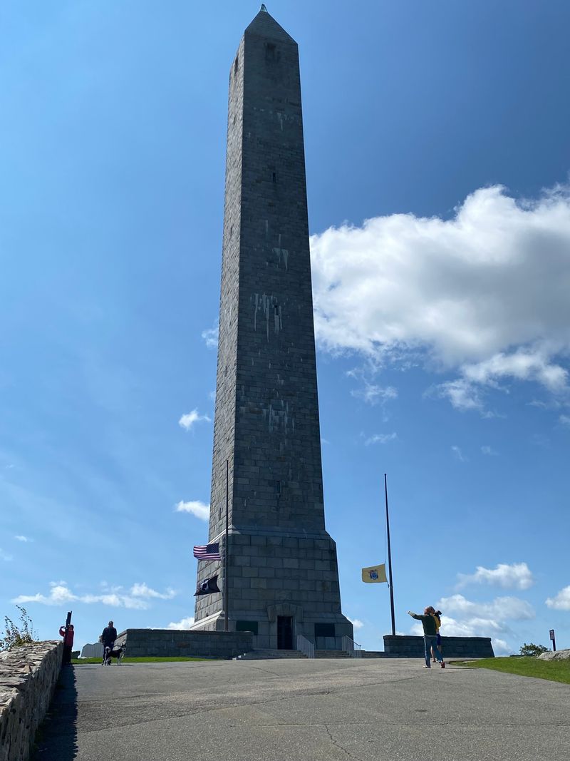
At 1,803 feet above sea level, High Point State Park at 1480 NJ-23, Wantage, NJ 07461, literally puts you on top of New Jersey. The stone monument marking the summit offers 360-degree views across three states, but the real show belongs to the folded and faulted ridges of the Appalachian Mountains stretching endlessly in every direction.
These parallel ridges and valleys formed hundreds of millions of years ago when tectonic plates collided, crumpling rock layers like a slow-motion car crash.
Hiking trails throughout the park cross exposed bedrock that shows clear evidence of the immense pressures that folded these mountains. You’ll see rock layers tilted at crazy angles, sometimes even flipped completely upside down by the forces involved.
The geology here tells the story of ancient mountain building that once created peaks rivaling the Himalayas, now worn down by erosion to the gentler ridges visible today.
The park’s elevation creates distinct ecosystems, with plants and animals at the summit differing from those in the valleys below. Spring wildflowers carpet the mountainsides while fall foliage turns the ridges into waves of red and gold.
Winter brings harsh conditions that sculpt the landscape through freeze-thaw cycles, continuing the erosion process that’s been shaping these mountains for eons.
Educational displays explain how geologists read the landscape like a history book, identifying different rock types and the forces that shaped them. The monument itself, built in 1930, provides a human-scale reference point that makes the vast geological timescales more comprehensible.
Standing at New Jersey’s highest point while surrounded by evidence of continental collisions and mountain building connects you directly to forces that shaped not just this state but entire continents.
7. The Great Swamp
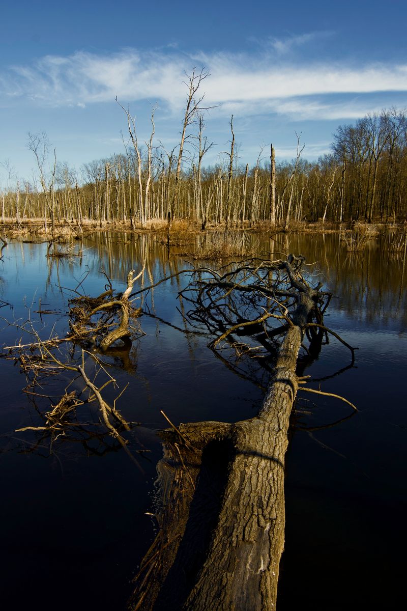
Imagine standing on the bottom of a lake that covered 30 miles and reached depths of 200 feet, except the water disappeared 12,000 years ago. The Great Swamp at 32 Pleasant Plains Rd, Basking Ridge, NJ 07920, represents the remaining bottom of Glacial Lake Passaic, a massive body of water formed when melting glaciers dumped so much water that natural drainage couldn’t keep up.
As the ice age ended and climate warmed, the lake slowly drained, leaving behind the flat wetland you see today.
Boardwalk trails let you explore this unique landscape without getting your feet wet while observing wildlife that thrives in the marsh environment. The soil beneath the swamp contains layers of sediment deposited on the ancient lake bottom, creating a geological record of climate changes over thousands of years.
Scientists study core samples from the swamp to understand how the environment responded to warming temperatures after the last ice age.
Bird watchers flock here because the swamp provides critical habitat for hundreds of species, many of which depend on wetlands that have become increasingly rare. The flat terrain and poor drainage that make this area unsuitable for development are direct results of its glacial lake origins.
Educational programs explain how glacial processes created not just this swamp but shaped much of northern New Jersey’s landscape.
Walking the trails during different seasons reveals how dynamic this environment remains, with water levels rising and falling, vegetation changing, and wildlife adapting to conditions. The Great Swamp nearly became a jetport in the 1960s until local activists fought to protect it, eventually leading to its designation as a National Wildlife Refuge.
Visiting connects you to both glacial history and conservation success while showcasing how ancient geological events continue influencing landscapes today.
8. Buttermilk Falls
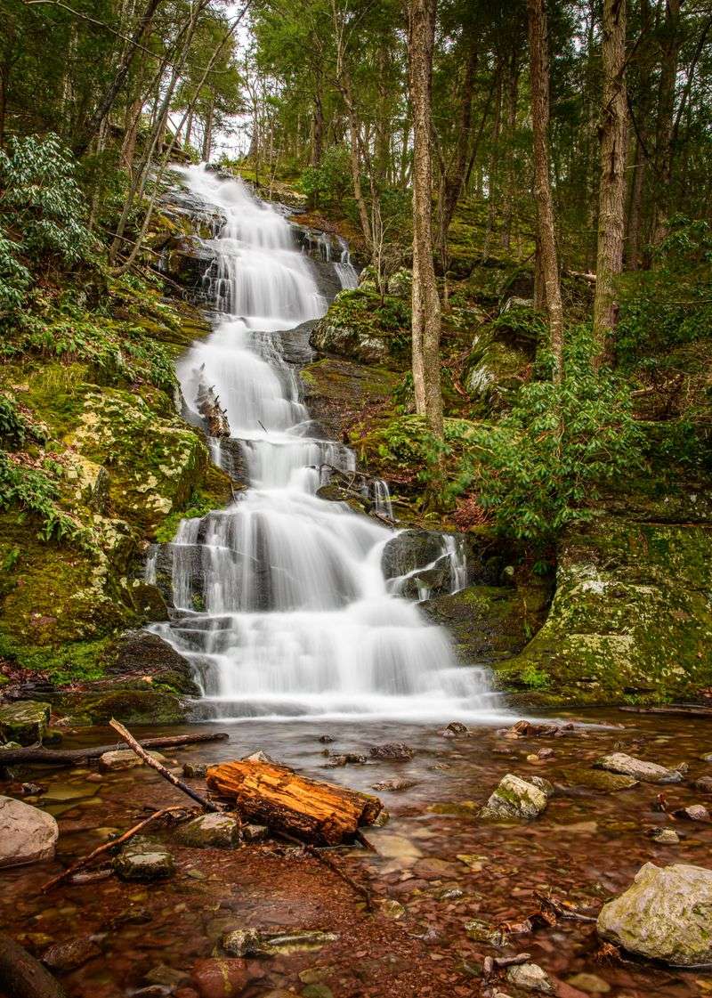
Cascading down layers of rock that tell stories of ancient seas and river deltas, Buttermilk Falls on Mountain Rd, Layton, NJ 07851, ranks among New Jersey’s tallest and most geologically interesting waterfalls. The water tumbles over alternating layers of Martinsburg Shale and Shawangunk Conglomerate, rocks deposited between 450 and 420 million years ago when this area sat under a shallow tropical sea.
Each layer represents a different ancient environment, from deep ocean muds to beach gravels.
The falls get their name from the frothy white appearance the water takes as it bounces down the layered rock face, creating a cascading effect rather than a single plunge. Geologists love this site because the exposed rock layers are so clearly visible, making it easy to see how different sediment types weather at different rates.
The harder conglomerate layers stick out as shelves while the softer shale erodes back, creating the stepped appearance of the falls.
Hiking to the base lets you examine the rock layers up close and see the fossils occasionally exposed in the shale, remnants of ancient sea creatures that lived when New Jersey was nowhere near its current location. The pool at the base shows ongoing erosion as swirling water and sediment grind away at the rock, slowly cutting the gorge deeper.
Spring brings maximum water flow, making the falls most impressive, though summer’s lower flows better reveal the rock structure.
The surrounding forest showcases how geology influences ecology, with different plant communities growing on the various soil types derived from the different rock layers. Photographers time their visits for the soft light of early morning or late afternoon when the falls and surrounding forest create magical compositions.
Standing before Buttermilk Falls connects you to ancient oceans and ongoing erosion processes that continue reshaping New Jersey’s landscape one water drop at a time.
9. Mount Mitchill Scenic Overlook
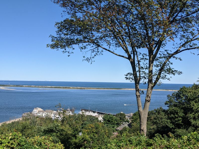
Perched 266 feet above sea level at 460 Ocean Blvd, Atlantic Highlands, NJ 07716, Mount Mitchill holds the distinction of being the highest natural point on the entire Eastern Seaboard south of Maine. This coastal bluff consists of Cretaceous-era sediment layers deposited roughly 70 million years ago when dinosaurs still roamed and New Jersey’s coastline sat much farther inland.
The sediments accumulated in a shallow marine environment, later uplifted and exposed by geological processes.
The overlook provides breathtaking views across Raritan Bay to New York Harbor and the Atlantic Highlands, but the real geological story lies in the exposed cliff faces below. These sediment layers contain fossils of ancient marine life including shark teeth, shells, and occasional dinosaur bones washed into the prehistoric sea.
Erosion constantly works on these cliffs, occasionally revealing new fossils and slowly wearing the headland back toward land.
On clear days, you can see the Manhattan skyline, the Verrazzano-Narrows Bridge, and Sandy Hook stretching into the ocean like a sandy finger. The elevation here results from the resistant nature of the sediment layers, which erode more slowly than surrounding materials.
Educational plaques explain how sea level changes, glacial processes, and erosion have shaped this coastline over millions of years.
The park attracts sunset watchers who gather to see the sun sink behind the New York skyline, creating spectacular photo opportunities. Geologists study the cliff exposures to understand how the coastline evolves and how climate change affects erosion rates.
The overlook’s strategic position made it a military observation post during both World Wars, taking advantage of the natural elevation provided by geological processes. Visiting Mount Mitchill connects you to ancient seas, coastal processes, and the ongoing changes that continue reshaping New Jersey’s shoreline with every tide and storm.
10. Sterling Hill Mining Museum
Descending into Sterling Hill Mining Museum at 30 Plant St, Ogdensburg, NJ 07439, means traveling back through 1.3 billion years of Earth history while surrounded by some of the planet’s rarest minerals. This former zinc mine operated for nearly a century, extracting ore from deposits that formed during the Precambrian era when Earth’s surface looked nothing like today.
The museum now showcases not just mining history but geological treasures that make scientists worldwide drool with envy.
The underground tour takes you through actual mine tunnels where you’ll see exposed ore bodies containing over 350 different mineral species, many found nowhere else on Earth. The mineral diversity here rivals and even exceeds the famous Franklin deposits just a few miles away, creating a geological hotspot that defies explanation.
Theories about how such incredible variety formed in one location involve complex interactions between ancient volcanic activity, metamorphism, and mineral-rich fluids.
The Rainbow Tunnel showcases fluorescent minerals that glow in impossible colors under ultraviolet light, creating an underground light show that seems more science fiction than science fact. Regular lighting reveals beautiful mineral specimens including franklinite, zincite, and willemite in their natural setting, not polished museum pieces but raw ore as miners encountered it.
The museum’s collection includes specimens so rare that only a handful exist worldwide.
Above ground, the museum complex features mining equipment, mineral displays, and educational exhibits explaining both mining operations and the geological processes that created these deposits. Rock collecting areas let visitors hunt for their own fluorescent specimens to take home.
Sterling Hill represents not just New Jersey mining history but a geological anomaly that continues puzzling scientists while delighting visitors with its underground beauty and incredible mineral wealth concentrated in this one remarkable location.
Dear Reader: This page may contain affiliate links which may earn a commission if you click through and make a purchase. Our independent journalism is not influenced by any advertiser or commercial initiative unless it is clearly marked as sponsored content. As travel products change, please be sure to reconfirm all details and stay up to date with current events to ensure a safe and successful trip.