Virginia is famous for its history and Blue Ridge scenery, but the state is hiding some seriously jaw-dropping natural secrets that most people completely overlook. I’m talking about slot canyons that rival the Southwest, ghost forests rising from sand dunes, and caves packed with geological formations found almost nowhere else on Earth.
Most Virginians have never even heard of these places, and that makes discovering them feel like striking gold. Pack your curiosity and your hiking boots, because this list is about to completely change how you see the Old Dominion.
The Great Channels of Virginia, Brumley Mountain
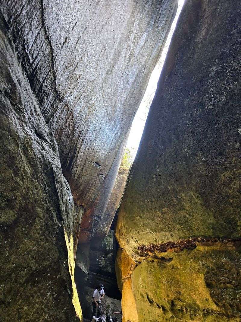
Forget everything you think you know about Virginia’s landscape. Tucked deep inside the Channels State Forest in Scott County, the Great Channels is a jaw-dropping maze of sandstone slot canyons that looks like it was airlifted straight from Utah and dropped into the Appalachian Mountains.
My first glimpse of those towering, narrow stone walls honestly stopped me in my tracks.
The canyons were carved over roughly 400 million years through a relentless process of ice wedging and erosion. Freeze-thaw cycles split the rock apart, inch by inch, millennium by millennium, creating a labyrinth of crevices deep enough to swallow you whole.
Some passages are so narrow you have to turn sideways to squeeze through, which makes the whole experience feel genuinely adventurous.
What makes this spot extra special is how few people know about it. The trail system requires a bit of navigation skill, so casual hikers rarely push all the way in.
That means on most weekday mornings, the entire canyon complex feels like your own private geological playground. Mossy boulders, fern-draped ledges, and the cool, shadowy air inside the channels create a mood that is almost otherworldly.
Spring and early fall are the best seasons to visit, when the forest canopy frames the stone walls in vivid green or blazing orange. The preserve is managed by the Virginia Department of Forestry, and access is free.
The nearest town is Dungannon, Virginia, and the trailhead is located off Clinch Mountain Wildlife Management Area Road in Scott County.
Devil’s Marbleyard, Blue Ridge Parkway
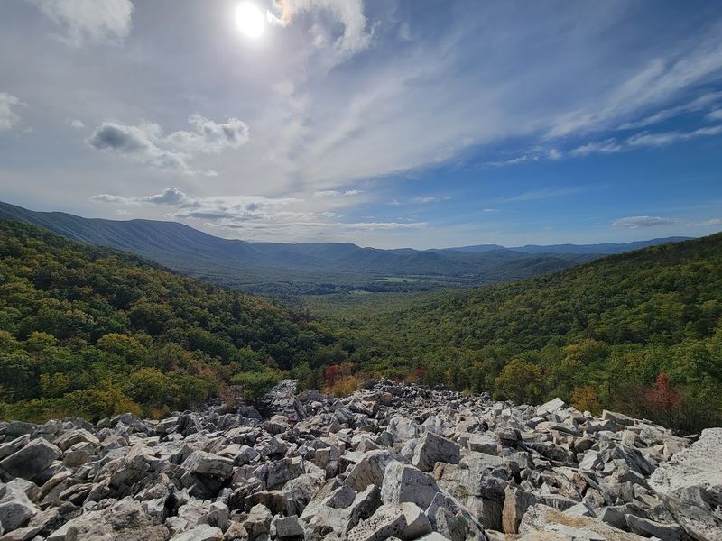
Stumbling onto Devil’s Marbleyard for the first time feels like discovering a giant’s abandoned playground. Spread across eight acres of mountainside near Natural Bridge in Rockbridge County, this surreal field of massive quartzite boulders is one of the most visually stunning and geologically fascinating spots in all of Virginia.
Nothing quite prepares you for the scale of it.
The boulders range from the size of small cars to full-on school buses, all tumbled and stacked in chaotic, photogenic piles. Geologists classify this as a periglacial feature, meaning it formed during the last ice age when repeated freeze-thaw cycles shattered the bedrock and sent chunks of stone sliding downslope over thousands of years.
The result is a rocky moonscape sitting right in the middle of lush Appalachian forest.
Scrambling across the boulders is half the fun and all of the workout. There is no formal path through the marbleyard itself, so you pick your own route, hopping from rock to rock while the forest falls away below you.
At the top of the boulder field, panoramic views of the surrounding ridges open up and make every scraped knee completely worth it.
The hike in follows the Belfast Trail, starting at the Belfast Trail parking area off Natural Bridge Road in Rockbridge County, Virginia. The trail is moderately challenging, roughly three miles round trip, and the boulder field rewards hikers who push through the wooded lower section.
Go on a clear autumn day and the colors framing those pale grey boulders are absolutely unforgettable.
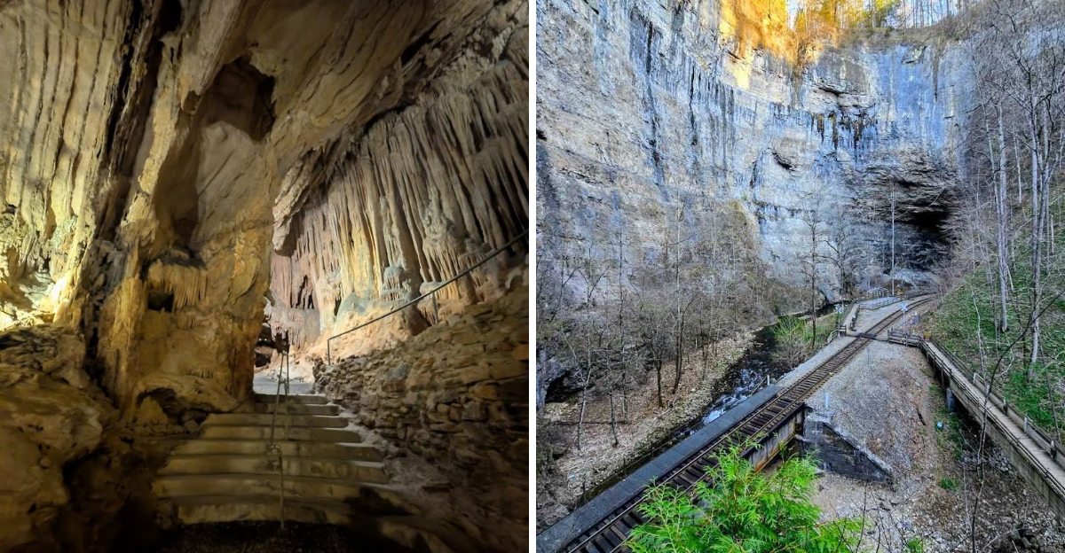
Natural Tunnel, Duffield
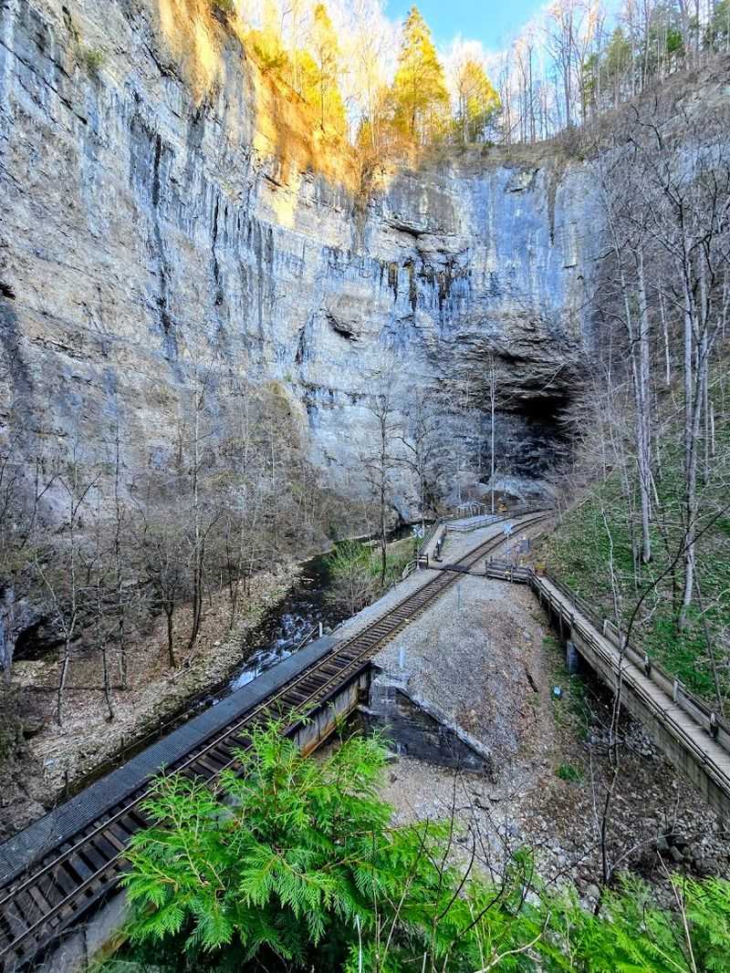
There are natural wonders, and then there is Natural Tunnel. Located near Duffield in Scott County, Virginia, this geological marvel is a massive limestone passage carved straight through a mountain ridge by Stock Creek over millions of years.
Standing at the observation deck and peering down at that yawning opening is genuinely one of the most humbling moments I have had outdoors in the eastern United States.
The tunnel stretches roughly 850 feet from end to end and rises as tall as a ten-story building at its highest interior point. What sets it apart from every other cave or cavern on this list is what runs through it: an actual, functioning freight railway.
Watching a train disappear into that enormous stone throat is a spectacle that never gets old, no matter how many times you see it.
William Jennings Bryan famously dubbed it the Eighth Wonder of the World, and once you see it in person, that title starts to feel less like hyperbole and more like a reasonable assessment. The surrounding Natural Tunnel State Park offers a chairlift ride down to the canyon floor, plus hiking trails that wind along the creek and through the surrounding hardwood forest.
The park also features a swimming pool, campground, and picnic facilities, making it a great full-day destination for families or solo explorers. Natural Tunnel State Park is located at 1420 Natural Tunnel Parkway, Duffield, Virginia.
Plan to spend at least half a day here because the canyon alone demands serious attention and unhurried exploration.
Sand Cave, Cumberland Gap
Sand Cave is the kind of place that makes you question your own eyes. Nestled within Cumberland Gap National Historical Park on the Virginia-Kentucky-Tennessee border, this extraordinary rock shelter is not a traditional cavern at all but a colossal stone overhang with a floor blanketed in deep, vividly colored sand.
The entrance stretches roughly 250 feet wide, giving the whole space a theatrical, cathedral-like presence.
Look up inside and the ceiling is streaked with sweeping bands of gold, rust red, and sage green, the result of mineral-rich water seeping through the rock over countless centuries. The sandy floor beneath your feet shifts in color too, ranging from pale cream to warm amber depending on the light filtering through the entrance.
It is the kind of geological canvas that makes amateur photographers very, very happy.
The cave sits along a moderate hiking trail within the park, making it accessible to most fitness levels. Because it is tucked inside a larger national park better known for its Civil War history and Appalachian Trail connections, Sand Cave rarely draws the crowds it deserves.
On a quiet morning, the only sounds are birdsong echoing off those ancient stone walls and the soft crunch of sand underfoot.
Cumberland Gap National Historical Park is located at 91 Bartlett Park Road, Middlesboro, Kentucky, though the Virginia section of the park is accessed via US Route 58 near Cumberland Gap, Virginia. The Sand Cave trail is well-marked from the main visitor center.
Bring a wide-angle lens and comfortable shoes for the walk in.
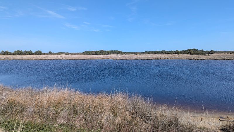
The Great Dismal Swamp and Lake Drummond, Chesapeake
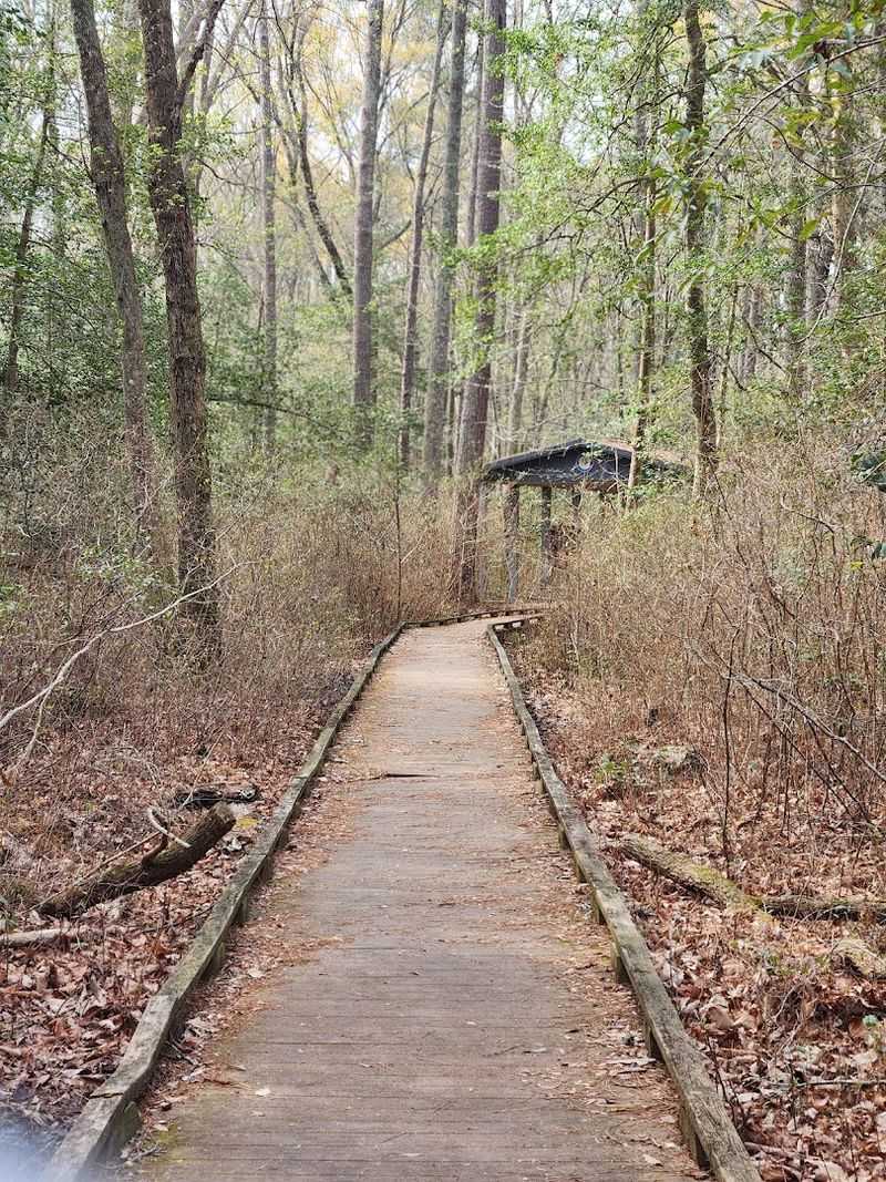
The name sounds like a warning, but the Great Dismal Swamp is one of the most hauntingly beautiful places in all of Virginia. Sprawling across roughly 112,000 acres on the Virginia-North Carolina border near Chesapeake, this ancient refuge is a world of moss-draped trees, dark mirror-like water, and a silence so complete it feels almost sacred.
I walked the boardwalk trail on a foggy morning and felt genuinely transported.
At the heart of the swamp lies Lake Drummond, one of only two natural freshwater lakes in the entire state. What makes it truly unusual is its shape: the lake is nearly perfectly circular, a rare formation that scientists believe may be linked to ancient peat fires that burned underground and collapsed the land above.
The water runs a deep amber-brown color from tannic acids released by decomposing vegetation, giving it an almost otherworldly appearance.
Ancient bald cypress trees ring the shoreline, their gnarled roots reaching into that dark water like outstretched fingers. The swamp is also a critical habitat for dozens of rare plant species and serves as a major stopover for migratory birds along the Atlantic Flyway.
Naturalists and birdwatchers consider it one of the most biodiverse corners of the mid-Atlantic region.
The Great Dismal Swamp National Wildlife Refuge Headquarters is located at 3100 Desert Road, Suffolk, Virginia. Canoe and kayak access to Lake Drummond is available via the Feeder Ditch Canal, and the Washington Ditch Road provides a flat, easy walking or cycling route into the heart of the refuge.
Breaks Interstate Park, Breaks
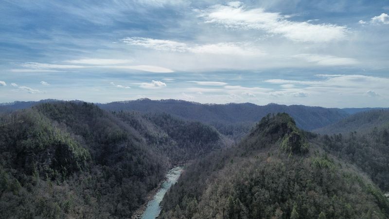
Calling Breaks Interstate Park the Grand Canyon of the South is not marketing fluff. It is a genuinely accurate description of one of the most dramatic landscapes east of the Mississippi River.
Straddling the Virginia-Kentucky border near the small town of Breaks, this park features a five-mile-long gorge cut by the Russell Fork River through Pine Mountain, plunging to depths that leave first-time visitors speechless.
The canyon walls rise in sweeping layers of sandstone and shale, draped in dense Appalachian hardwood forest that ignites in spectacular color every October. Overlooks along the rim deliver views that feel more like Wyoming than southwestern Virginia, and the sheer scale of the gorge floor below creates a vertigo-inducing sense of depth that photographs simply cannot capture.
Whitewater rafting through the gorge during autumn dam releases on the Russell Fork is considered some of the most intense whitewater paddling in the eastern United States. The park also offers calmer pleasures: hiking trails, a lake, a lodge, cottages, and some of the most peaceful forest camping in the region.
Crowd levels here are refreshingly low compared to parks in northern Virginia.
Breaks Interstate Park is managed jointly by Virginia and Kentucky, a genuinely rare arrangement that gives it its unusual interstate designation. The park is located at 627 Commission Drive, Breaks, Virginia.
Fall is absolutely the prime season to visit, when the canyon walls transform into a riot of red, gold, and amber that reflects in the river far below. Book a rim-view cabin early because they fill up fast in October.
Falls Ridge Preserve, Elliston
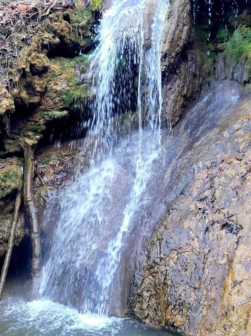
Falls Ridge Preserve is the kind of place that geologists dream about and most hikers have never heard of. Managed by The Nature Conservancy, this quiet preserve near Elliston in Montgomery County, Virginia, contains one of the largest and most spectacular travertine deposits in the entire world.
That is not a regional superlative but a genuine global one, which makes the almost total lack of tourist crowds here pretty remarkable.
Travertine forms when calcium carbonate-rich spring water surfaces and deposits mineral crust layer by layer over centuries. At Falls Ridge, a spring-fed waterfall drops roughly 80 feet over bulbous, brain-like rock formations that look like something from a science fiction film set.
The shapes are soft, rounded, and almost organic, completely unlike the angular stone you find in most Virginia landscapes.
The surrounding bluffs are riddled with small caves and overhangs, and the forest floor around the falls stays lush and green even in late summer thanks to the constant moisture from the spring. Rare ferns, mosses, and wildflowers carpet the area, thriving in the mineral-rich microclimate created by the travertine deposits.
Botanists have recorded plant communities here that exist almost nowhere else in the mid-Atlantic.
Access to Falls Ridge Preserve requires a free permit from The Nature Conservancy’s Virginia Chapter, which helps keep visitor numbers low and the ecosystem intact. The preserve is located off Harts Run Road near Elliston, Virginia, in Montgomery County.
Spring visits offer the most dramatic waterfall flow, while summer brings lush greenery that frames those extraordinary rock formations beautifully.
Savage Neck Dunes, Cape Charles
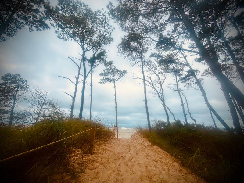
Most people picture Virginia’s Eastern Shore as flat, quiet farmland stretching toward the sea. Savage Neck Dunes near Cape Charles blows that image apart completely.
This Virginia Department of Conservation and Recreation natural area preserve features some of the tallest sand dunes on the entire Delmarva Peninsula, rising up to 50 feet high along a mile of wild, undeveloped Chesapeake Bay shoreline that feels genuinely remote and untouched.
The dunes are dramatic enough on their own, but what makes Savage Neck truly eerie and unforgettable is the ghost forest. Ancient pines stand dead and bleached white at the forest edge where the advancing dunes have slowly buried their root systems over decades.
These skeletal silver trunks rising from the sand create one of the most visually striking and photogenic landscapes in all of Virginia.
Behind the dunes, maritime forest takes over, with gnarled live oaks, bayberry shrubs, and wax myrtle creating a dense coastal thicket alive with migratory songbirds in spring and fall. The preserve sits along the Atlantic Flyway, making it a serious destination for birdwatchers during migration season.
Shorebirds, raptors, and warblers all pass through in impressive numbers.
Savage Neck Dunes Natural Area Preserve is located at the end of Savage Neck Road, Northampton County, near Cape Charles, Virginia. The access road is unpaved and can be rough, so a vehicle with decent clearance is helpful.
Parking is limited and the trail to the dunes is short but rewarding. Sunrise visits are absolutely spectacular when the low light catches those pale dune faces and ghost-white tree trunks.
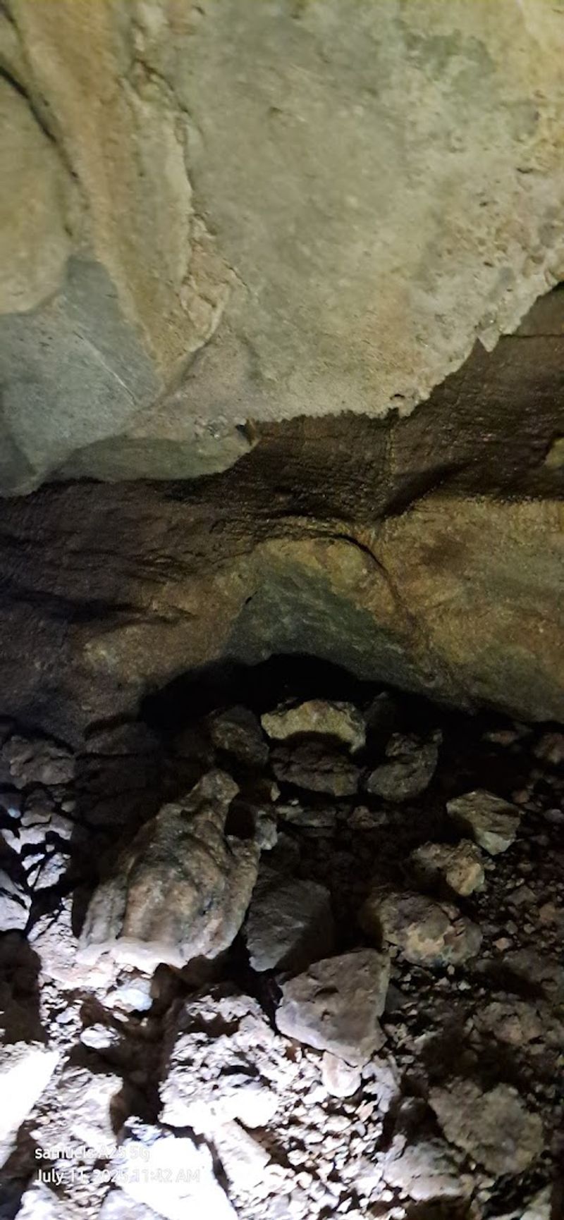
Grand Caverns, Grottoes
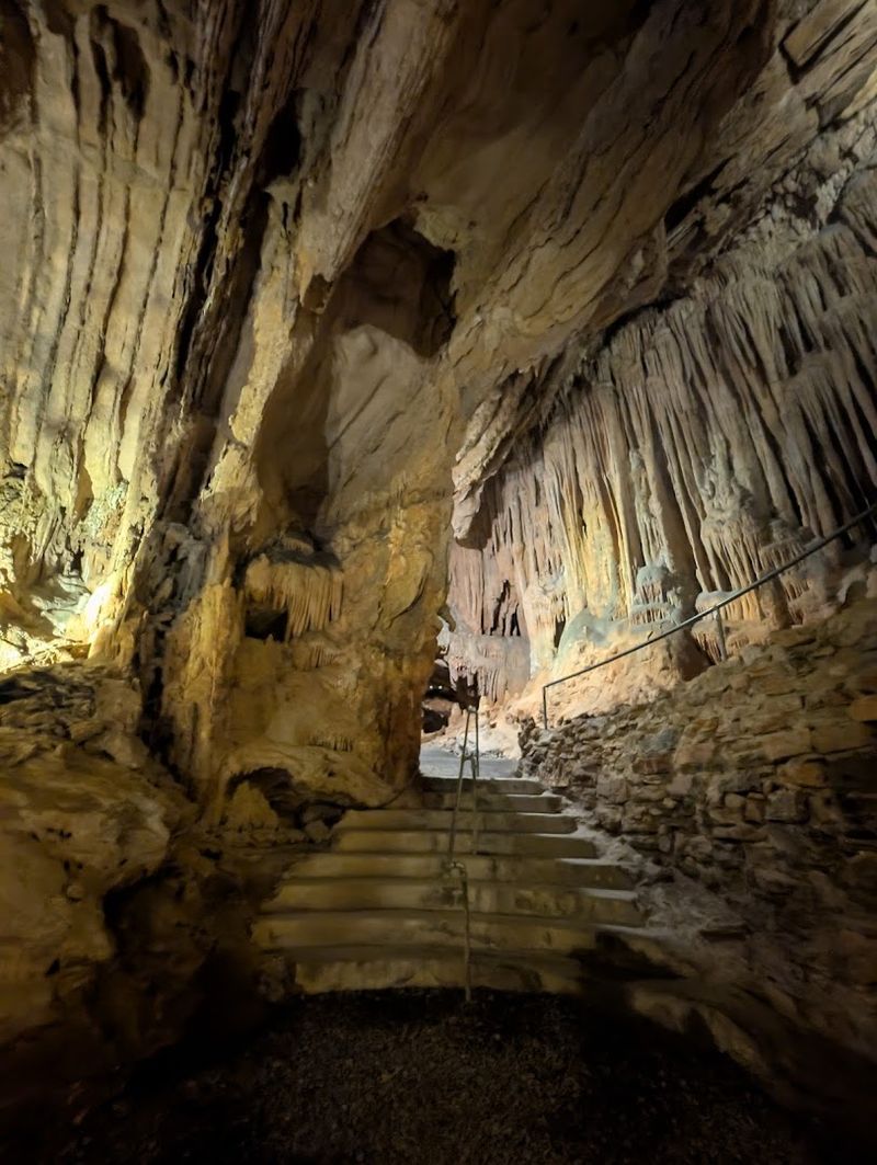
Luray Caverns gets all the postcards, but Grand Caverns in Grottoes quietly holds a title that puts it in a category of its own: America’s oldest continuously operated show cave. Long before Luray was even discovered, Grand Caverns was already welcoming curious explorers, and its geological contents give it every right to claim the spotlight.
I spent over an hour underground here and came out genuinely dazzled.
The star attraction is the shield formations. These large, flat, circular rock plates jut from the cave walls and ceilings like oversized stone dinner plates, and they are geologically uncommon even by global standards.
Grand Caverns contains hundreds of them, a concentration that has made the cave a subject of serious scientific study. Nobody fully understands exactly how shields form, which adds a layer of mystery to every guided tour.
Beyond the shields, the cave features soaring Cathedral Hall, a chamber large enough to have hosted dances during the Civil War era, when soldiers from both sides reportedly visited the cavern during lulls in nearby fighting. The ceiling formations in Cathedral Hall are breathtaking, with massive stalactites and flowstone curtains draped across the rock in waves of cream and rust.
Grand Caverns is located at 5 Grand Caverns Drive, Grottoes, Virginia, in Augusta County. Guided tours run regularly throughout the day and last approximately one hour.
The cave maintains a constant cool temperature year-round, so a light jacket is always a good idea. Combine a visit here with a stop at nearby Shenandoah National Park for a full and deeply satisfying Virginia day trip.
False Cape State Park, Virginia Beach
Getting to False Cape State Park is half the adventure. There are no roads in.
Reaching this extraordinary stretch of pristine Atlantic coastline near Virginia Beach requires hiking or cycling through Back Bay National Wildlife Refuge, arriving by boat, or catching a seasonal tram. That deliberate inaccessibility is exactly what has kept False Cape one of the last genuinely wild coastal landscapes on the entire East Coast.
Stretching along the Atlantic shoreline south of Back Bay, the park protects a rare and largely undisturbed barrier spit environment. Maritime forest, freshwater impoundments, tidal flats, and open beach all exist in close proximity here, creating a mosaic of habitats that supports an extraordinary diversity of wildlife.
Loggerhead sea turtles nest on the beach in summer, and the birding during fall migration is the kind that makes serious birders audibly gasp.
The campground at False Cape sits right at the edge of the dunes, meaning you fall asleep to the sound of Atlantic waves and wake up to shorebirds picking through the surf. There are no concession stands, no gift shops, and no cell service worth mentioning.
The stars at night are outrageous. It is primitive camping in the most rewarding sense of the phrase, and the silence it offers feels increasingly rare in modern Virginia.
False Cape State Park is located at 4001 Sandpiper Road, Virginia Beach, Virginia. Reservations for camping and tram access are required and should be made well in advance, especially for summer and fall visits.
Bring everything you need because the park is fully self-sufficient territory once you arrive. This is Virginia at its most beautifully untamed.
Dear Reader: This page may contain affiliate links which may earn a commission if you click through and make a purchase. Our independent journalism is not influenced by any advertiser or commercial initiative unless it is clearly marked as sponsored content. As travel products change, please be sure to reconfirm all details and stay up to date with current events to ensure a safe and successful trip.