Hawaii’s secret paths promise emerald valleys, thundering waterfalls, and cliffside panoramas worthy of a thousand likes. But behind those viral views are hazards, laws, and cultural boundaries many visitors never see until it’s too late. This guide reveals the risks and realities turning “hidden” trails into tourist nightmares – and how to avoid becoming a headline. Read on to balance adventure with respect, safety, and the true spirit of aloha.
Misleading Social Media Photos
That breezy ridge selfie hides a reality of narrow ledges, crumbly footing, and hours of bushwhacking. Wide-angle lenses flatten steepness, overexposure brightens gloomy gulches, and captions omit the bailouts, bruises, and fines. Influencers rarely show the sketchy rope sections, trespass points, or stormy retreats. Don’t plan with posts – verify with topo maps, official websites, recent trip reports, and local clubs. Scrutinize elevation gain, exposure, and required permits. If a photo shows a dramatic precipice, assume serious objective hazards and wind. Ask yourself if you could downclimb everything you go up. Bring essential gear even for “easy” Instagram hikes. And remember: geotagging fragile or closed places accelerates damage and conflict. Share responsibly, or better, spotlight sanctioned trails that can handle the traffic.
Ignoring “Closed” Signs
The thrill of slipping past a gate for a forbidden view tempts many, but “closed” in Hawaii often means lethal hazards or sacred places – sometimes both. Ha?ik? Stairs and Sacred Falls are prime examples: one closed due to liability and trespass concerns, the other after a deadly rockfall. Ignore the signs and you risk fines, arrests, and footing the bill for rescue or damages. Social media glamorizes the reward and hides the citations, angry neighbors, and court summons. Instead, choose permitted alternatives with similar scenery, and verify status on official sites before you go. If a route crosses private or culturally sensitive land, turn back. Your best photo won’t outweigh legal trouble, community harm, or your safety. Respect closures – they exist because someone got hurt, or worse.
Unpredictable Weather and Flash Floods
Hawaii’s weather can pivot from sunny to deadly within minutes, especially in narrow valleys and slot-like gulches. A distant downpour you never see can unleash a flash flood that roars through canyons, sweeping hikers, packs, and bridges away. Trails that look benign become torrents; crossings vanish under brown, churning water. Forecasts help but aren’t perfect – microclimates rule. Check radar before departing, note recent rainfall, and heed rising water, rumbling sounds, or sudden water discoloration. Turn around if clouds stack over ridgelines or if streams rise. Move to higher ground fast; don’t attempt to outrun water in a confined valley. Pack a headlamp, emergency blanket, and a whistle. The best defense is timing your hike for stable weather and choosing routes with safe exit options.
Extremely Slippery and Unstable Terrain
Volcanic mud, algae-covered roots, and crumbly tuff turn many “hidden” trails into slip-and-fall factories. A drizzle creates grease-slick tread; a downpour liquefies slopes and triggers rockfall. Knife-edge ridges crumble at the edges, while eroded steps collapse underfoot. Falls here mean more than scrapes – think broken ankles, concussions, or a slide into dense uluhe ferns that trap you. Trekking poles, lugged footwear, and a conservative pace are essential. Step on solid surfaces, test footholds, and keep three points of contact on steep sections. If a slope feels like wet soap, it probably is; retreat before commitment. Don’t assume dry conditions – humidity keeps surfaces slick. Skip shortcuts that undercut switchbacks and worsen erosion. Stable footing – and humility – prevent the most common rescue callouts.
Lack of Trail Maintenance and Markers
Hidden or unofficial routes seldom receive upkeep, so vegetation swallows paths, markers vanish, and side spurs multiply. A wrong turn into a pig trail can strand hikers in head-high ferns with no sightlines. Streams braid into multiple channels, and windfall hides the true route. Without maintenance, slopes erode into ruts that funnel you toward cliffs. Carry offline maps, a GPS device or app with downloaded layers, and a paper backup. Track your breadcrumb trail and set turnaround times tied to daylight. If navigation feels uncertain for more than a few minutes, backtrack to known points rather than “shortcutting.” Tell someone your plan and expected return. Maintenance matters: choose state-managed trails when possible, and don’t remove ribbons or carve bark – both harm the resource.
Underestimating Difficulty and Physical Demands
Humidity, relentless elevation gain, and exposure make moderate mileage feel brutal in Hawaii. Knife-edge ridges tax balance and nerve; steep climbs spike heart rates and dehydrate fast. Even strong hikers fade when heat and sweat soak electrolytes. Assess fitness honestly and pick routes with bailout options. Start early to avoid afternoon buildups, rest in shade, and pace for steady progress. If the ridge narrows beyond comfort, turn back before commitment points. Do not push personal limits when wind gusts rise or storms threaten. Train on official trails first to gauge footing and stamina. Respect the gap between gym fitness and real-world terrain. The best summit is the safe one you reach – and return from – without risking a rescue call that endangers responders.
Inadequate Gear and Supplies
Flip-flops and a dead phone turn a scenic stroll into a survival problem. Hidden trails demand lugged shoes, 2–3 liters of water, electrolytes, snacks, rain shell, headlamp, first-aid kit, and a charged phone with offline maps – plus a whistle. Gloves help on ropes and sharp lava. Cotton stays wet; wear moisture-wicking layers. Pack a small emergency blanket in case you’re benighted. Power banks matter in humid heat that drains batteries quickly. Don’t count on trail water being safe – filters or purification tablets are vital. Helmets are smart on crumbly or waterfall routes. Minimalism looks cool online but fails in mud, rain, and wind. Prepare like you’ll be slower than planned and finish after dark. The right kit transforms risk into manageable adventure.
Expensive and Dangerous Rescues
Rescues on steep ridges, waterfalls, and remote valleys put firefighters, lifeguards, and volunteers in harm’s way. Helicopters battle wind and terrain while ground teams navigate mud and exposure. Visitors may face bills, fines, or travel delays, and communities bear the load when resources are diverted. Many incidents stem from preventable choices: ignoring closures, poor footwear, or hiking past turn-around times. Reduce risk by choosing permitted routes, carrying essentials, and honoring weather windows. If injured, stay put once you’ve called for help – wandering complicates search patterns. Better yet, avoid needing rescue: set conservative goals, hike with partners, and communicate plans. Remember, every risky decision recruits strangers into your emergency. Responsible preparation is the cheapest insurance you’ll ever buy.
Disrespecting Local Culture and Sacred Sites
Some “secret” hikes trespass across private lands, kapu areas, or near burial caves and heiau. Cutting fences, littering offerings, or posing on sacred stones disrespects Native Hawaiian culture and strains relations with neighbors. Expect citations, community backlash, and closures that punish everyone. Learn place names and meanings; if a site is kapu or unpermitted, don’t go. Choose guided cultural walks or official trails that interpret history respectfully. Pack out all trash, keep noise low, and never move stones or markers. Ask permission when in doubt. Your visit should leave no trace on culture as well as nature. Respect turns a hike into relationship-building; disrespect turns it into a flashpoint. Aloha is action: listen, learn, and tread with humility.
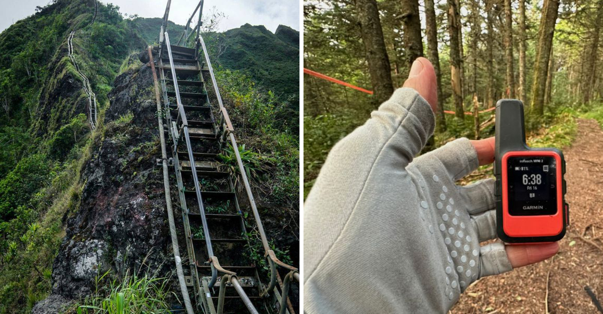
Lack of Cell Service
Deep valleys, sea cliffs, and dense canopy often block signals, turning minor mishaps into serious ordeals. Navigation apps fail without offline maps, and calling for help may require climbing to exposed ridgelines. Plan for no service: download maps, share your itinerary, and set a hard turnaround time. Carry a whistle (three blasts), mirror, and headlamp for signaling. A satellite messenger or PLB is invaluable on remote routes and can expedite rescue with coordinates. Put phones in airplane mode to save battery; check service only at safe, stable spots. Without comms, self-sufficiency matters – first aid, warm layers, and patience. Treat every hidden trail as off-grid, and you’ll be ready when the bars disappear.
Dear Reader: This page may contain affiliate links which may earn a commission if you click through and make a purchase. Our independent journalism is not influenced by any advertiser or commercial initiative unless it is clearly marked as sponsored content. As travel products change, please be sure to reconfirm all details and stay up to date with current events to ensure a safe and successful trip.