Arkansas has a famous waterfall. Everyone knows it.
Postcards. Instagram.
The whole deal. But that is not the bluest one.
I found the real winner on a random Tuesday, following a trail that was more of a suggestion than a path. The water was the color of a swimming pool, turquoise and clear, pooling at the bottom of a drop that was not even that tall. Height does not matter when the color stops you cold.
I sat on a rock, ate a sandwich, and watched the water spill over mossy stone. No crowds.
No gift shop. Just blue.
Arkansas hides its best spots where nobody thinks to look. This waterfall is proof.
The Drive In: What to Expect Before You Even Hit the Trail

Nobody warns you about the road, and that is the first thing worth knowing. The drive to Kings River Falls Natural Area is not your typical pull-into-a-parking-lot experience.
You will be navigating narrow, winding roads, some of them gravel, some of them dirt, and a few stretches that feel more like a suggestion than an actual road.
The address is 1543 Madison 3500, Witter, AR 72776, but here is a heads-up: Google Maps tends to drop a pin slightly before the actual trailhead. Keep driving past where the map tells you to stop.
The real parking area and the trailhead sign will come into view just around a curve, clearly marked and worth the extra few seconds of uncertainty.
Coming from County Road 5, it is worth taking AR-16 into Madison 3605 rather than attempting County Road 404, which can be rough on standard vehicles. A standard car can make the trip, but go slow and give yourself extra time.
There is no cell service out here, so downloading an offline map before you leave is genuinely useful advice, not just a suggestion.
No restrooms are available at the trailhead either, so plan ahead. Arriving on a weekday gives you a much better chance of having the place nearly to yourself.
The reward waiting at the end of the trail makes every bumpy mile feel completely worth it.
The Trail Itself: Easy Hiking With a Whole Lot of Character

The Kings River Falls Trail is one of those hikes that feels almost too easy at first. It is roughly 1.4 to 2 miles round trip depending on where you park, and the elevation change is minimal.
But do not let the word easy fool you into showing up in flip flops, because the trail has personality in the form of rocks, roots, and uneven ground that keep you paying attention the whole way.
The path follows Mitchell Creek, a tributary of the Kings River, and the sound of moving water is almost constant. That gurgling backdrop makes the whole walk feel meditative in a way that a smooth paved trail never quite manages.
You notice more when the environment is a little wild around you.
Blue trail blazes mark the route, so getting lost is unlikely. The trail is mostly shaded, which is a serious bonus during Arkansas summers when the heat can be punishing.
Patches of soft sand, loose rock, and mossy ground alternate underfoot, giving the hike a varied texture that keeps things interesting.
Sturdy shoes or hiking boots are genuinely recommended here. Some sections get muddy after rain, and wet rocks near the creek can be slippery.
Keep an eye out for water snakes near the riverbanks, they are harmless but worth knowing about. Children handle this trail well, and even younger kids tend to enjoy the creek sounds and small discoveries along the way.
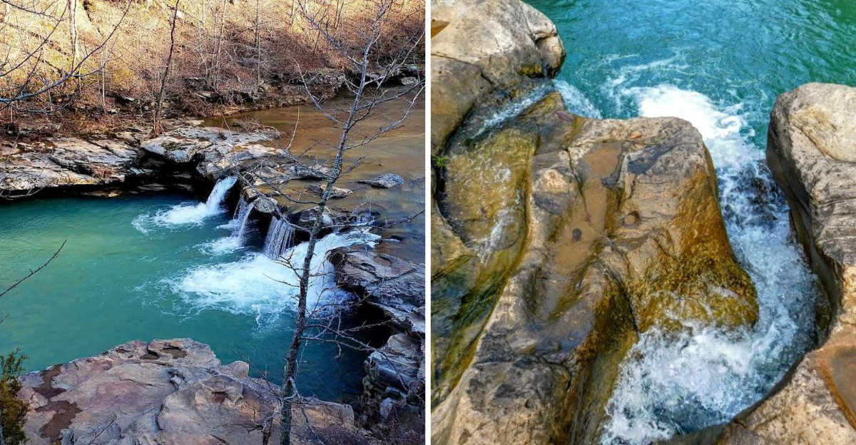
The Waterfall: That Color Is Absolutely Real

The first glimpse of the falls through the trees hits differently than expected. The water is not just blue in a vague, poetic way.
It is genuinely, visibly turquoise, the kind of color you associate with Caribbean beaches rather than the Arkansas Ozarks. That contrast is exactly what makes this place feel so surprising and so memorable.
Kings River Falls is a shelf waterfall, roughly 10 feet tall, where the Kings River spills over a wide limestone ledge and crashes into a deep pool below. The rocky shores fan out around the swimming hole, creating natural seating areas where you can sit and just absorb the whole scene.
The clarity of the water is remarkable, you can see straight to the bottom even in the deeper sections.
The turquoise color comes from the crystal-clear mountain water interacting with the light and the pale limestone bedrock beneath. After a few days of rain, the falls run full and powerful, and the pool deepens noticeably.
Mid-spring through early summer tends to offer the best water levels and the richest color.
People jump from the falls into the pool below, and the swimming hole is genuinely deep enough for it during good water levels. Even on a drier visit, the pool holds water well and stays refreshingly cool.
Bringing water shoes is smart, because the rocks around the falls are uneven and can be sharp in spots. This is not a waterfall you just photograph and leave.
Swimming at Kings River Falls: A Natural Pool Worth Getting Wet For

Plenty of Arkansas swimming holes are nice. This one is on a different level.
The pool at the base of Kings River Falls is deep, clear, and cold in the best possible way, especially after a sweaty hike in summer heat. The moment you step in, the temperature is a full-body reset that feels almost shockingly refreshing.
The rocky ledges around the pool work naturally as spots to sit between swims, dry off, or eat a snack while watching the water. There is something genuinely relaxing about the whole setup.
The sound of the falls, the cool air hovering near the water, and the surrounding forest canopy create an atmosphere that is hard to replicate anywhere else.
Jumping from the falls is popular when water levels are high enough to make the pool deep. It is the kind of moment that sticks with you, the brief second of freefall before the cold water swallows you whole.
Kids who visit often describe it as one of the most fun outdoor experiences they have had, and it is easy to see why.
Water shoes make navigating the rocky edges much easier and more comfortable. Towels are essential since there are no facilities on site.
Packing a light snack and plenty of water for the trip is a good call, especially since the nearest towns are a solid drive away. Weekday visits in early summer offer the best balance of good water levels and fewer crowds at the swimming hole.
Wildlife and Nature Along the Kings River: More Than Just a Waterfall

The trail to Kings River Falls is not just a means to an end. The forest and river corridor along the way are full of small moments that make the whole outing feel richer.
Small fish dart through the shallower sections of the creek, visible through the crystal-clear water, and the occasional bald eagle has been spotted circling above the river corridor on the way in.
The Ozark landscape here sits at the intersection of the Springfield Plateau and the Boston Mountains, which creates a layered, diverse ecosystem. Wildflowers appear along the trail edges in spring, adding unexpected color to the green and brown palette of the forest floor.
The geological formations along the riverbanks are genuinely interesting, with exposed limestone and sandstone layers telling a long, slow story about how this landscape formed.
Water snakes are present near the river and worth watching for, though they are not aggressive and generally move away when people approach. Staying aware and keeping to the trail is all that is needed.
The fish in the river are small and friendly, and spotting them through the clear water is one of those small joys that makes the hike feel alive rather than just scenic.
The mostly shaded trail keeps the ambient temperature noticeably cooler than open terrain, which makes the wildlife more active and the walk more pleasant. Bringing a camera with good zoom is worth it here, because the natural details reward a closer look.
Tips for Visiting Kings River Falls Natural Area: How to Make the Most of Your Trip

A little preparation goes a long way at Kings River Falls, because this is not a destination with backup options nearby. No restrooms, no food vendors, no cell service, and no paved roads for the last stretch of the drive.
That list sounds discouraging, but it is actually what keeps the place feeling so untouched and genuinely wild.
Download an offline map before leaving, because the signal disappears well before you reach the trailhead. Keep in mind that Google Maps places the pin slightly short of the actual parking area.
Just continue past where the map ends and look for the trailhead sign on the left side of the road. It is clearly visible once you round the last curve.
Pack water, snacks, towels, and water shoes as non-negotiables. A small backpack makes carrying everything comfortable without slowing you down on the trail.
Wearing boots or sturdy trail shoes is smarter than sneakers, especially if recent rain has made the path muddy.
Visiting mid-week in late spring or early summer gives you the best combination of high water levels and manageable crowds. Summer weekends can get busy, and the swimming hole fills up fast when the weather is hot.
Early morning arrivals also tend to be quieter and cooler. The falls run year-round, but the color and volume are most dramatic after a few days of rainfall.
Every season brings something different, and even a drier visit is worth the trip.
Address: 1543 Madison 3500, Witter, AR 72776
Dear Reader: This page may contain affiliate links which may earn a commission if you click through and make a purchase. Our independent journalism is not influenced by any advertiser or commercial initiative unless it is clearly marked as sponsored content. As travel products change, please be sure to reconfirm all details and stay up to date with current events to ensure a safe and successful trip.