Louisiana’s waterways have shaped communities in ways few other places can claim.
Along winding rivers and through marshy deltas, entire villages grew up where roads couldn’t reach and boats became as common as cars.
These river settlements tell stories of resilience, tradition, and a way of life that flows with the current rather than against it.
From the mouth of the mighty Mississippi to the banks of the Red River, these communities invite travelers to experience a slower, more connected rhythm where water defines daily existence.
1. Pilottown
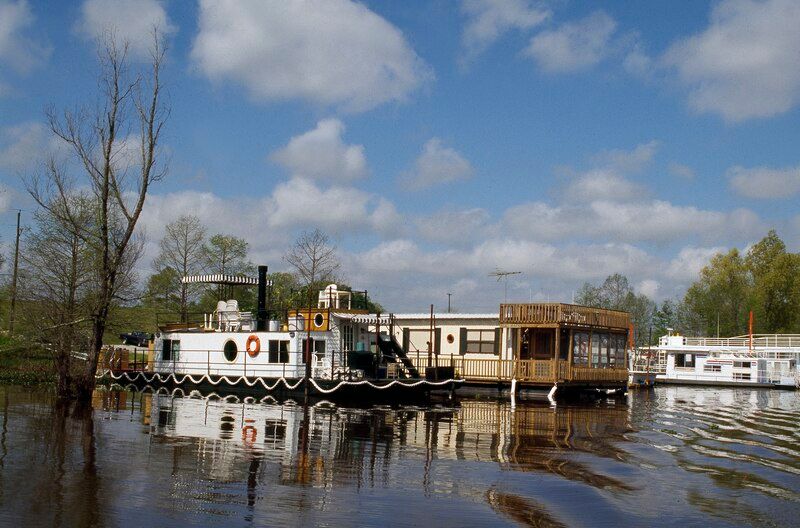
Perched at the very edge of Louisiana where the Mississippi River meets the Gulf of Mexico, Pilottown exists in a world few people ever witness.
This settlement was built entirely on piers and pilings, rising above the swampy delta terrain that makes traditional roads impossible.
Established in the 1800s, Pilottown served as a strategic base for river pilots who guided massive ships through the treacherous final miles of the Mississippi.
These skilled navigators needed to live close to their work, and since solid ground was scarce, they built their community on wooden platforms connected by walkways.
Every single trip to Pilottown requires a boat or helicopter because there simply is no other way to get there.
Supplies arrive by water, workers commute by boat, and the rhythm of life follows the tides and river currents.
By 2020, Pilottown had no permanent residents, functioning instead as a rotation base where pilots stay during their shifts before returning to homes upriver.
The structures stand weathered but sturdy, painted in fading colors that speak to decades of salt air and storm winds.
Oil exploration companies also use Pilottown as an operational hub, bringing a different kind of maritime traffic to these remote waters.
Walking through Pilottown feels like stepping onto a floating frontier town, where the sounds of lapping water and distant boat engines replace typical neighborhood noises.
The isolation creates an atmosphere both eerie and fascinating, a reminder that some places remain stubbornly untamed by modern infrastructure.
For travelers willing to arrange boat transport, visiting Pilottown offers a glimpse into a vanishing way of life where water is not just nearby but underneath everything.
2. Jean Lafitte
Named after the legendary pirate and privateer, Jean Lafitte embodies the mysterious allure of Louisiana’s bayou country.
Located southwest of New Orleans in Jefferson Parish, this village sits surrounded by vast wetlands where waterways twist through cypress forests and marshes teeming with wildlife.
Boats here are not recreational luxuries but essential tools for reaching fishing spots, checking crab traps, and accessing camps tucked deep in the swamps.
Many families in Jean Lafitte have lived off these waters for generations, maintaining traditions of shrimping, oystering, and fishing that date back centuries.
The community centers around Bayou Barataria, a wide, slow-moving waterway that serves as the main highway for local boat traffic.
Wooden docks extend from backyards, and small aluminum boats sit ready at nearly every home, often used more frequently than the cars parked out front.
Children grow up learning to navigate shallow channels and read water conditions the way other kids learn to ride bicycles.
The Jean Lafitte National Historical Park and Preserve borders the village, protecting thousands of acres of wetlands that residents have always considered their backyard.
Boardwalk trails wind through the preserve, but the real Jean Lafitte experience comes from gliding through narrow bayous in a flat-bottomed boat.
Alligators sun themselves on muddy banks, herons stalk through shallows, and the air hangs thick with humidity and the scent of brackish water.
Local fishing guides offer tours that reveal hidden corners of the swamp while sharing stories passed down through generations of bayou dwellers.
Jean Lafitte represents a living connection to Louisiana’s pirate past and its enduring relationship with the water that surrounds it.
3. Atchafalaya Basin Communities
The Atchafalaya Basin sprawls across nearly a million acres, forming America’s largest river swamp and home to scattered communities that exist between water and land.
Settlements here developed in places where slightly higher ground emerged from the floodplain, but even these spots disappear underwater during high water seasons.
Families built camps on tall stilts, creating neighborhoods that seem to float above the swamp floor during spring floods.
Boats tie up beneath houses like cars in driveways, and narrow waterways serve as streets connecting one camp to another.
Crawfishing provides income for many basin residents, who run traplines through the flooded forests from small boats loaded with wire mesh traps.
The rhythm of life here follows water levels and seasons rather than typical calendars, with spring bringing high water and abundant crawfish while summer lowers the swamp and concentrates fish in remaining channels.
Some basin camps have been in the same families for four or five generations, passed down along with knowledge of secret fishing holes and safe passages through confusing maze-like waterways.
Generators provide electricity since power lines cannot reach most camps, and supplies arrive by boat from small towns along the basin’s edges.
The isolation appeals to people who prefer solitude and self-reliance, though cell phones and satellite internet have recently connected even remote camps to the outside world.
Traveling through the Atchafalaya Basin reveals a landscape that feels prehistoric, where cypress knees jut from dark water and every sound carries across the stillness.
Commercial tour operators based in nearby towns offer guided boat trips into the basin, but the real residents navigate these waters with an intimate knowledge outsiders can only admire.
4. Delacroix Island
Delacroix Island sits at the southeastern edge of St. Bernard Parish, where land dissolves into a maze of marshes, bayous, and open bays leading to the Gulf.
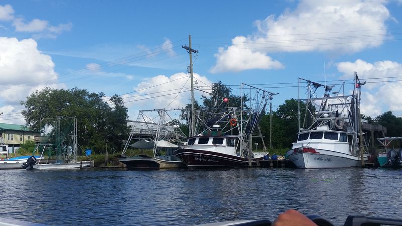
This fishing village has survived hurricanes, oil spills, and coastal erosion that constantly reshapes the landscape around it.
Commercial fishing boats crowd the docks, their tall outriggers and nets indicating the serious business of shrimping and oystering that sustains the community.
Many Delacroix families trace their ancestry to Canary Islanders who settled here in the 1700s, bringing fishing traditions that continue today.
The village spreads along Bayou Terre aux Boeufs, with homes facing the water and boats always within reach.
During shrimp season, the bayou becomes a busy waterway filled with trawlers heading out before dawn and returning with holds full of ice and catch.
Children often skip school during peak fishing times to help their families, learning skills that cannot be taught in classrooms.
Delacroix Island Road provides vehicle access, but once you arrive, exploring the surrounding marshes and fishing grounds requires a boat.
The village has a rugged, working atmosphere quite different from tourist-oriented Louisiana towns, with marine supply shops and seafood docks outnumbering restaurants or gift shops.
Hurricane Katrina devastated Delacroix in 2005, pushing storm surge across the low-lying land and destroying many homes.
Yet the community rebuilt, demonstrating the stubborn resilience of people whose livelihoods and identities are inseparable from these waters.
Visitors who venture to Delacroix discover authentic Louisiana fishing culture, where boats are not toys but tools and the Gulf’s bounty still feeds families.
5. Grand Isle
Grand Isle stretches along a narrow barrier island at Louisiana’s southernmost point, where the Gulf of Mexico meets Barataria Bay.
This unique position makes boats essential for both work and recreation, with fishing charters, shrimp boats, and pleasure craft sharing the waters.
The island’s only land connection is Louisiana Highway 1, which crosses miles of marsh and water on bridges and elevated roadway before reaching Grand Isle.
Once there, the island’s layout encourages boat use, with marinas, boat launches, and private docks lining both the Gulf side and the bay side.
Grand Isle has long attracted anglers pursuing redfish, speckled trout, and offshore species like tuna and marlin.
Charter captains maintain busy schedules during fishing season, guiding visitors to productive spots while sharing stories of remarkable catches and narrow escapes from sudden Gulf storms.
The island’s year-round population remains small, but summer weekends bring crowds of fishermen and beach lovers who arrive with boats in tow.
Houses stand on tall pilings, a necessary precaution on an island that sits barely above sea level and has endured countless hurricanes.
Grand Isle State Park occupies the eastern end of the island, offering camping, fishing piers, and beach access for visitors who want to experience barrier island life.
Commercial shrimpers and oystermen from Grand Isle work the rich waters of Barataria Bay, continuing traditions that stretch back generations.
The island’s exposed position makes it vulnerable, yet this very vulnerability creates the dynamic ecosystem that draws fish, birds, and the people who depend on them.
Grand Isle embodies the intersection of recreation and subsistence, where boats serve every purpose imaginable in a community shaped entirely by surrounding water.
6. Bayou Lafourche Communities
Bayou Lafourche flows for over a hundred miles from the Mississippi River to the Gulf, creating a liquid main street for communities that developed along its banks.
Towns like Thibodaux, Raceland, Lockport, and Golden Meadow line both sides of the bayou, with Louisiana Highway 1 running parallel but the water remaining the true center of life.
Boats outnumber cars in many backyards, tied to private docks that extend into the slow-moving bayou.
The waterway once served as the primary transportation route for the entire region, with steamboats and barges carrying goods and passengers before highways were built.
Today, commercial shrimp boats and crew boats serving offshore oil platforms still use Bayou Lafourche as their highway to the Gulf.
The bayou’s banks sit close together, making it feel intimate despite accommodating large vessels, and drawbridges punctuate the route where roads cross the water.
When bridges open for tall boats, traffic stops and locals wait patiently, understanding that water traffic has equal rights to the roadway.
Fishing from bayou-side docks is a daily activity for many residents, who cast lines for catfish, bass, and redfish while chatting with neighbors doing the same.
The Cajun and Creole cultures thrive along Bayou Lafourche, with boat-based traditions like crawfish boils, fishing rodeos, and blessing of the fleet ceremonies marking the seasons.
Hurricane protection levees now line portions of the lower bayou, but these communities remain intimately connected to the water that flows past their front doors.
Traveling down Bayou Lafourche reveals how a single waterway can define an entire region’s character, economy, and way of life across multiple generations.
7. Venice
Venice sits at the absolute end of Louisiana Highway 23, where the road literally runs out and only water continues southward toward the Gulf.
This position at the Mississippi River’s final navigable point before the delta makes Venice a crucial hub for both fishing and offshore oil operations.
Marinas crowd the riverbanks, packed with charter fishing boats, commercial vessels, and crew boats that ferry workers to oil platforms dozens of miles offshore.
The town exists because boats go where roads cannot, serving as the last supply point and staging area before the open Gulf.
Venice’s economy revolves entirely around marine activities, with boat captains, deckhands, mechanics, and fuel dock operators forming the core workforce.
Sport fishermen travel from around the world to launch from Venice, pursuing trophy tuna, marlin, and other species in the deep waters beyond the river’s mouth.
The Mississippi River current runs strong and brown past Venice’s docks, carrying sediment that has built Louisiana over millennia while also contributing to coastal erosion problems.
Beyond Venice, the river splits into multiple passes threading through marshes and mudflats before finally merging with the Gulf.
These passes, with names like South Pass, Southwest Pass, and Pass a Loutre, can only be navigated by boat, making Venice the gateway to a vast water wilderness.
Hurricane damage has repeatedly battered Venice, with storms pushing Gulf waters far inland and testing the resolve of residents who rebuild each time.
The town has a frontier feel, with utilitarian buildings focused on function rather than aesthetics and an atmosphere of people who work hard in challenging conditions.
Venice represents the end of the road in the most literal sense, where Louisiana dissolves into the Gulf and boats become the only way forward.
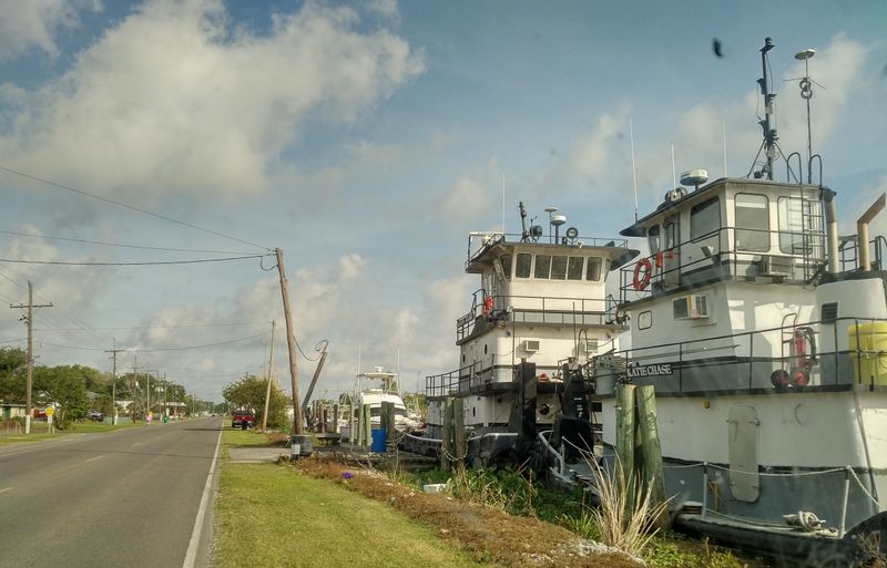
8. Belle Chasse and Scarsdale Ferry
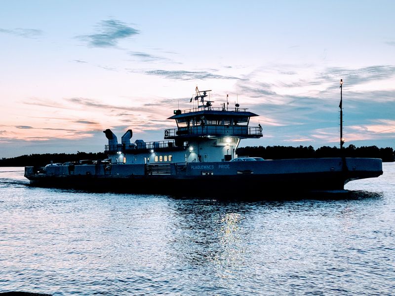
The Belle Chasse to Scarsdale Ferry represents a vital transportation link in Plaquemines Parish, connecting communities separated by the wide Mississippi River.
This ferry operates as the furthest downriver vehicle crossing of the Mississippi, serving an area where building bridges becomes impractical due to the river’s width and the presence of heavy ship traffic.
For residents on either side, the ferry is not a tourist attraction but a necessary part of daily life, used for commuting to work, accessing services, and visiting family.
The ferry runs on a regular schedule, with the boat making the crossing multiple times each day, carrying cars, trucks, and occasionally pedestrians across the powerful current.
Standing on the ferry deck during crossing offers a perspective on the Mississippi that few people experience, with the river’s immense power evident in the swirling eddies and the boat’s struggle against the flow.
Belle Chasse on the west bank has grown into a substantial community with schools, businesses, and residential neighborhoods, while Scarsdale on the east bank remains smaller and more rural.
Without the ferry, residents of Scarsdale would face a drive of many miles northward to find the nearest bridge, making simple errands into lengthy expeditions.
The ferry service continues a long Louisiana tradition of water-based transportation solutions in a landscape where rivers often prove more practical than roads.
Watching the ferry approach the landing, workers securing vehicles with practiced efficiency, and feeling the boat’s engines rumble underfoot all reinforce how water transportation remains relevant even in modern times.
The crossing takes only minutes, but those minutes connect communities and enable a way of life that honors Louisiana’s river heritage while serving contemporary needs.
9. Red River Waterway Towns
The Red River cuts through north-central Louisiana for over 200 miles, creating a ribbon of navigable water that connects small towns and rural communities.
Unlike the massive Mississippi, the Red River maintains a more intimate scale while still serving as a significant transportation and recreation corridor.
Towns like Alexandria, Natchitoches, and Coushatta grew up along the Red River’s banks, using the waterway for commerce and transportation long before highways existed.
The Red River Waterway Commission manages this stretch, maintaining locks, dams, and navigation channels that keep the river accessible for boats of various sizes.
Dozens of boat launches dot the riverbanks, providing public access for fishing, skiing, and pleasure cruising that has become increasingly popular.
Commercial barge traffic still uses the Red River to transport agricultural products and industrial goods, though recreational boating now dominates the waterway.
The river’s name comes from the reddish sediment it carries, giving the water a distinctive rust-colored appearance that contrasts with surrounding green forests.
Small riverside communities along the Red River maintain boat docks and marinas where locals keep fishing boats and pontoons for weekend outings.
The waterway creates a natural gathering place, with riverside parks and campgrounds drawing families who want to enjoy Louisiana’s river culture.
Fishing for bass, catfish, and other species remains a primary activity, with tournaments attracting serious anglers from across the region.
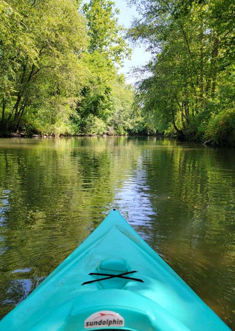
The Red River’s relatively gentle current and scenic wooded banks make it ideal for kayaking and canoeing, activities that have grown in popularity as people seek quieter outdoor experiences.
Red River communities demonstrate how waterways continue shaping Louisiana life, providing both practical transportation and recreational opportunities that connect people to the state’s flowing heart.
Dear Reader: This page may contain affiliate links which may earn a commission if you click through and make a purchase. Our independent journalism is not influenced by any advertiser or commercial initiative unless it is clearly marked as sponsored content. As travel products change, please be sure to reconfirm all details and stay up to date with current events to ensure a safe and successful trip.