Oregon doesn’t play by the usual rules when it comes to landscapes.
While most states stick to one or two signature looks, this Pacific Northwest wonder decided to collect nearly every geological oddity it could find and scatter them across its borders like nature’s personal art gallery.
You’ll find lakes that vanish into thin air each summer, deserts that stretch endlessly in a state known for rain forests, and sinkholes that appear to gulp down entire oceans. Some of these places look so surreal that your brain might need a moment to process what your eyes are seeing.
From volcanic craters filled with impossibly blue water to ancient fissures you can walk through, Oregon’s landscape reads like a fantasy novel written by Mother Nature herself.
These ten spots prove that sometimes reality outdoes imagination, and you don’t need a passport to another planet when Oregon offers up scenery this otherworldly right in your backyard.
1. Thor’s Well, Yachats
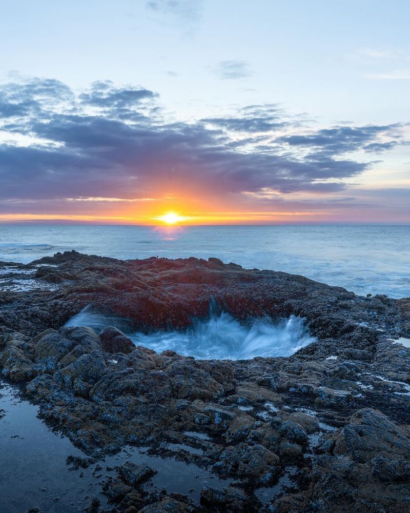
Standing at the edge of the Pacific watching water disappear into what looks like a bottomless pit never gets old, no matter how many times you’ve seen it happen. Thor’s Well sits along the rugged Oregon coast near Yachats, and locals have nicknamed it the drainpipe of the Pacific for good reason.
This natural wonder is actually a large bowl-shaped hole carved into the rocky shore that fills and empties with each wave cycle. During high tide, especially when storms whip up the ocean, water rushes into the well with tremendous force before draining back out through underground channels.
The effect creates the illusion that the ocean itself is being sucked down into the earth.
Timing your visit makes all the difference here. Arrive about an hour before high tide for the most dramatic displays, when waves crash over the rim and create spectacular fountains of spray.
The surrounding basalt shelf gets slippery fast, so sturdy shoes with good grip are essential.
Photographers flock to this spot because the lighting during golden hour transforms the scene into something magical. The combination of crashing waves, dramatic rock formations, and that mysterious void creates images that look almost too perfect to be real.
Just remember to keep a safe distance because sneaker waves can appear without warning and sweep unwary visitors off their feet.
2. Painted Hills, Eastern Oregon
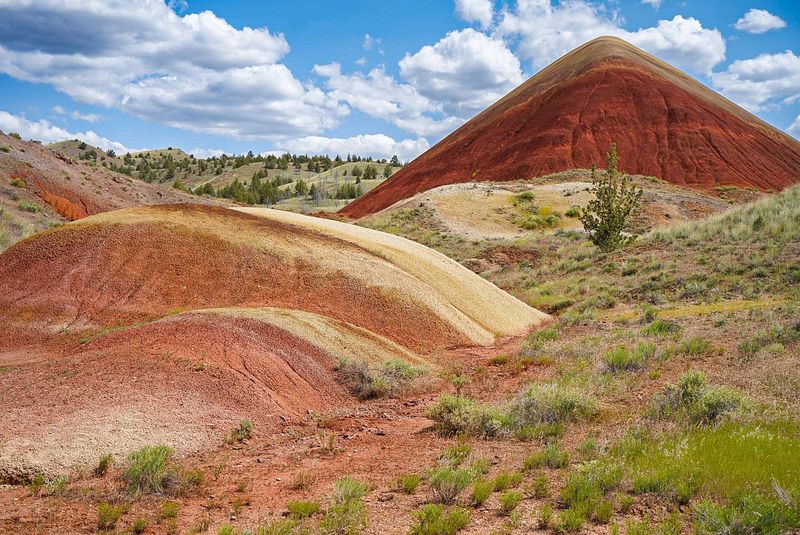
Colors this vivid usually require a paint store, not a geological formation that’s been sitting in the high desert for millions of years. The Painted Hills section of the John Day Fossil Beds looks like someone took a giant brush and striped the landscape with every warm tone imaginable.
Each colored band represents a different time period in Earth’s history, stretching back roughly 35 million years. The red and pink layers come from volcanic ash that oxidized in a warm, wet climate.
Gold and tan bands formed during drier periods, while black streaks mark ancient soil rich in organic matter from long-gone forests.
Weather conditions dramatically affect how the colors appear. After rain, the hills practically glow with saturated hues that photographers dream about.
Dry summer days create softer, more muted tones that still impress but lack that jaw-dropping intensity.
Several trails wind through the hills, with the Painted Hills Overlook Trail offering the best panoramic views for minimal effort. Carroll Rim Trail takes you higher for a bird’s eye perspective of the entire painted landscape.
Early morning and late afternoon light enhance the natural color variations, making the hills look like they’re lit from within.
The area remains relatively uncrowded compared to other Oregon attractions, which means you can often have these prehistoric masterpieces almost entirely to yourself.
3. Crater Lake, Southern Oregon
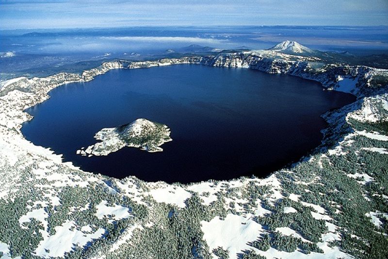
Volcanoes typically leave behind destruction, but Mount Mazama decided to create something breathtaking instead when it collapsed 7,700 years ago. What remained became Crater Lake, the deepest lake in the United States at 1,943 feet, filled with water so blue it almost hurts to look at.
No rivers or streams feed this lake. Every drop comes from rain and snowfall, which means the water stays incredibly pure and clear.
Scientists can see objects 100 feet below the surface on calm days, and that clarity combined with the depth creates that signature cobalt blue color that doesn’t quite look real in photographs.
Wizard Island rises from the lake’s surface like a miniature volcano, because that’s exactly what it is. This cinder cone formed from eruptions after the main collapse, and you can actually hike to its summit if you take the boat tour that runs during summer months.
Winter transforms the area into a snow-covered wonderland where the rim road closes but cross-country skiing and snowshoeing open up. Summer brings wildflowers and hiking opportunities along the 33-mile Rim Drive.
The Cleetwood Cove Trail is the only legal path down to the water’s edge, and it’s a steep one-mile descent that you’ll definitely feel on the way back up.
Plan to spend several hours here because one quick look never feels like enough.
4. Alvord Desert, Southeastern Oregon
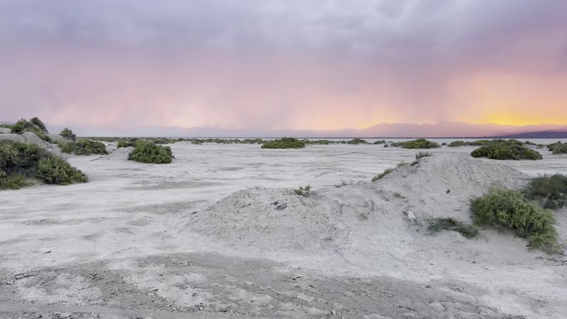
Finding a genuine desert in Oregon surprises most people, but the Alvord Desert delivers exactly that experience with its massive expanse of cracked, white earth. This dry lake bed stretches for miles at the base of Steens Mountain, creating a landscape that feels more like Australia’s outback than the Pacific Northwest.
The playa floods during wet seasons, turning into a shallow lake that eventually evaporates and leaves behind those distinctive cracked-mud patterns. When completely dry, the surface becomes hard enough to drive on, and some visitors use it as a natural runway for small aircraft.
Hot springs bubble up along the desert’s edge, providing a surreal contrast between the barren flats and steaming pools.
Summer temperatures can soar above 100 degrees, while winter brings freezing conditions and occasional snow. Spring and fall offer the most comfortable visiting conditions, though you’ll want to check weather forecasts because storms can make the dirt access roads impassable.
The night sky here ranks among the darkest in Oregon. Without light pollution for miles in any direction, the Milky Way appears so clearly you can practically count individual stars.
Photographers set up camp to capture star trails and time-lapse sequences that showcase the desert’s otherworldly beauty.
Bring plenty of water, fuel, and supplies because services are sparse in this remote corner of Oregon. The nearest town sits about 60 miles away, so self-sufficiency isn’t optional.
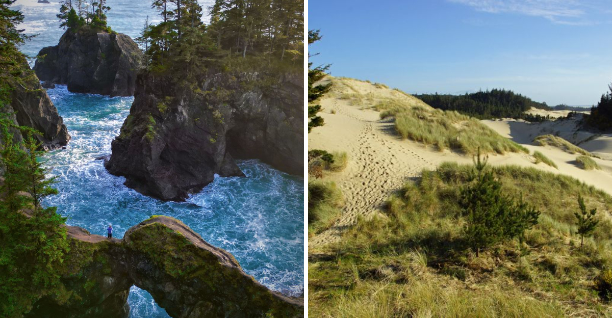
5. Natural Bridges, Brookings
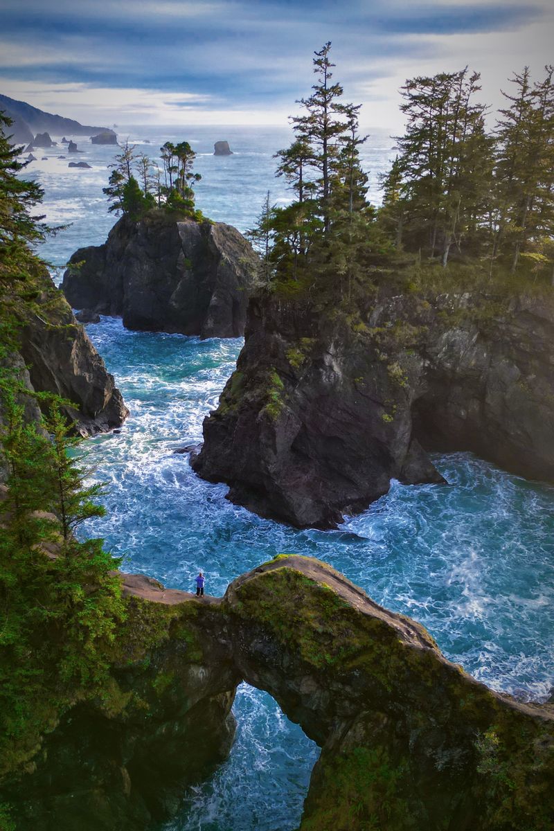
Ocean waves spent thousands of years carving tunnels through solid rock to create these spectacular natural bridges near Brookings. The result is a collection of arched formations that you can admire from clifftop viewpoints or, if you’re feeling adventurous, explore up close via steep trails.
Samuel H. Boardman State Scenic Corridor contains these bridges, along with numerous other geological wonders scattered along 12 miles of pristine coastline.
The main Natural Bridges formation consists of several rock arches that frame the ocean perfectly, creating photo opportunities that look professionally staged.
Low tide reveals sea caves and tide pools teeming with marine life around the bridges’ bases. Starfish cling to rocks, anemones wave their tentacles, and small crabs scuttle between pools.
The narrow trails leading down require good balance and a healthy respect for slippery surfaces, but the payoff makes the careful descent worthwhile.
Viewing platforms perched on the cliffs offer safer alternatives for those who prefer keeping their feet on solid ground. These overlooks provide dramatic perspectives of the bridges silhouetted against crashing waves and endless ocean.
Sunset transforms the scene into a spectacular display of orange and pink light reflecting off wet rocks.
Winter storms create the most dramatic wave action, though they also make the trails more hazardous. Summer brings calmer conditions and better visibility for spotting whales migrating along the coast.
Pack layers regardless of season because coastal weather changes quickly here.
6. Lost Lake, Mount Hood
Lakes aren’t supposed to vanish like magic tricks, but Lost Lake near Mount Hood performs exactly that disappearing act every single summer. The water drains completely through underground lava tubes, leaving behind a grassy meadow where boats floated just months earlier.
Geologists believe the lake sits atop ancient lava flows riddled with tubes and channels that act like natural plumbing. As snowmelt decreases and evaporation increases during summer, the drainage rate exceeds the inflow rate, and the lake slowly empties.
By late summer, you can walk across the dry lake bed and peer into the main drain hole that swallows all that water.
The drainage process typically begins in June and reaches completion by September or October. Winter precipitation and spring snowmelt refill the lake, and the cycle repeats annually.
Scientists still debate where exactly all that water goes, though it likely feeds underground aquifers and eventually emerges elsewhere.
When full, Lost Lake offers excellent fishing, kayaking, and swimming opportunities. The Mount Hood views reflected in the calm water create postcard-perfect scenes that attract photographers year-round.
Hiking trails circle the lake and connect to longer routes through the surrounding forest.
The mysterious drain hole itself has become a tourist attraction. During low water periods, visitors gather around the opening to watch water spiral downward and disappear.
Dropping sticks into the vortex and watching them vanish never gets old, regardless of your age.
7. Oregon Dunes National Recreation Area
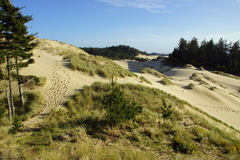
Sand dunes towering up to 500 feet high seem wildly out of place along Oregon’s typically rocky coast, but here they are anyway, stretching for 40 miles between Florence and Coos Bay. These massive formations inspired Frank Herbert’s science fiction masterpiece Dune, and once you see them in person, the connection makes perfect sense.
Wind constantly reshapes these dunes, moving sand grains and creating new formations while erasing old ones. The landscape you see today will look different next month, and completely transformed in a year.
Some dunes remain relatively stable, anchored by beach grass and shore pine, while others shift and migrate with seasonal wind patterns.
Hiking across the sand provides a serious workout because your feet sink with each step, making progress slower than you’d expect. The reward comes when you crest a tall dune and see the Pacific Ocean spreading out before you, with more dunes rolling away in every direction.
The silence up there feels almost complete, broken only by wind and distant waves.
Off-road vehicle enthusiasts flock to designated areas where dune buggies and ATVs can legally roam. Other sections remain vehicle-free, preserving the wilderness experience for hikers and nature lovers.
Several lakes dot the dune landscape, creating oases where you can cool off after trekking through sand.
Summer brings the most visitors and warmest temperatures, while winter offers solitude and dramatic storm-watching opportunities.
8. Crack-in-the-Ground, Christmas Valley
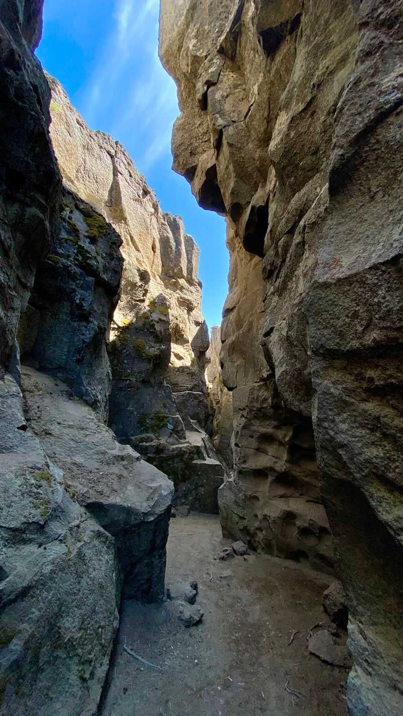
Earthquakes didn’t create this two-mile-long fissure in the high desert near Christmas Valley. Instead, cooling volcanic rock contracted and split apart roughly 1,000 years ago, leaving behind a crack that reaches 70 feet deep in places and narrow enough to touch both walls simultaneously.
Walking through the crack feels like exploring another world. Walls of dark basalt rise on either side, blocking wind and creating a microclimate that stays significantly cooler than the surrounding desert.
Temperature differences can reach 20 degrees or more, making this a popular summer escape for locals who know about it.
The crack’s floor remains relatively smooth and easy to navigate, though occasional rock falls and debris require watching your step. Sunlight filters down from above, creating dramatic lighting effects as the day progresses.
Some sections narrow to just a few feet wide, while others open up enough for small groups to walk side by side.
Vegetation thrives in the crack’s protected environment despite the harsh desert conditions above. Mosses, lichens, and small plants cling to the walls where moisture collects.
Birds nest in crevices, and lizards sun themselves on warm rocks near the crack’s rim.
The remote location means you’ll likely have this geological wonder mostly to yourself. Dirt roads lead to the site, and high-clearance vehicles handle them better than standard cars.
9. Smith Rock State Park, Terrebonne
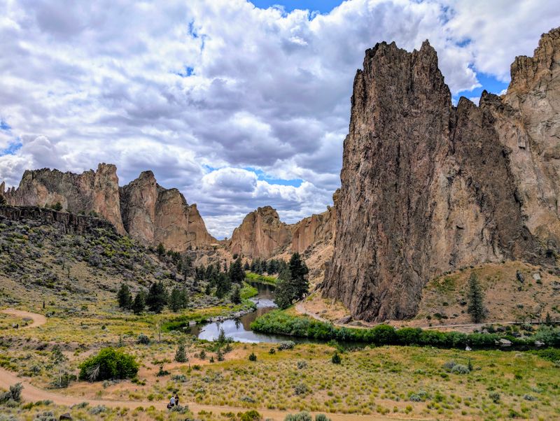
Sheer cliffs of volcanic ash and basalt erupt from the high desert floor with such dramatic flair that first-time visitors often stop mid-stride to stare. Smith Rock State Park looks like it belongs in Utah or Arizona, not in Oregon just 30 minutes from Bend.
Rock climbers from around the world pilgrimage here to tackle routes that range from beginner-friendly to terrifyingly difficult. The park helped pioneer American sport climbing in the 1980s, and you’ll see climbers dotting the cliff faces on any decent weather day.
Watching them navigate seemingly impossible routes provides free entertainment from the ground.
The Crooked River winds through the canyon bottom, creating a green ribbon of life that contrasts beautifully with the orange and gold rock towers. Several hiking trails explore the park, with the Misery Ridge Trail offering the most spectacular views in exchange for a steep, heart-pounding climb.
Summit Ridge Trail provides a less strenuous alternative that still delivers impressive vistas.
Morning light paints the rocks in warm tones that photographers obsess over, while sunset creates equally stunning color shows. Wildlife includes golden eagles, prairie falcons, mule deer, and river otters that play in the water below the cliffs.
Summer temperatures can exceed 100 degrees, making spring and fall the most comfortable seasons for hiking. Winter brings snow occasionally, transforming the park into a completely different landscape.
10. Tamolitch Falls (Blue Pool), McKenzie River
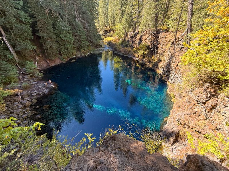
Waterfalls typically require water falling from somewhere, but Tamolitch Falls breaks that rule spectacularly. The McKenzie River disappears underground for three miles, then emerges into a pool so brilliantly blue and clear that it looks artificially lit from beneath.
Ancient lava flows created the underground channels that swallow the river upstream. The water travels through this subterranean network before bubbling up at Tamolitch, which means “bucket” in the local Chinook language.
The pool’s incredible clarity comes from the natural filtration that occurs as water permeates through volcanic rock.
That vivid blue color results from the pool’s depth and purity. Sunlight penetrates deep into the crystal-clear water, and the way light scatters creates those mesmerizing turquoise and sapphire tones.
On sunny days, the pool practically glows, and the effect seems too perfect to be natural.
The two-mile hike to reach the Blue Pool follows an old road bed through lush forest along the dry riverbed. The trail is relatively flat and easy, making it accessible for most fitness levels.
During the hike, you’ll see where the river vanishes into the lava, leaving behind a rocky channel that water hasn’t flowed through for thousands of years.
Swimming is technically allowed, though the water temperature hovers around a teeth-chattering 37 degrees year-round. Most visitors content themselves with admiring the pool’s beauty and dipping fingers or toes for bragging rights.
Dear Reader: This page may contain affiliate links which may earn a commission if you click through and make a purchase. Our independent journalism is not influenced by any advertiser or commercial initiative unless it is clearly marked as sponsored content. As travel products change, please be sure to reconfirm all details and stay up to date with current events to ensure a safe and successful trip.