Montana holds some of the most incredible natural scenery in America, where mountains touch clouds and wild rivers carve through ancient rock.
This Big Sky Country stretches across millions of acres filled with dramatic peaks, crystal-clear lakes, and endless prairies that seem to go on forever.
Whether you love hiking rugged trails, photographing stunning vistas, or simply standing in awe of nature’s power, Montana delivers experiences you’ll never forget.
The landscapes here aren’t just beautiful; they’re transformative, offering a chance to disconnect from daily stress and reconnect with something much bigger than yourself.
From glacier-carved valleys to thundering waterfalls, each location tells a story millions of years in the making.
Getting outside in Montana means stepping into scenes that look almost too perfect to be real, yet they exist right here waiting for you to explore.
Pack your sense of adventure and prepare to witness nature at its absolute finest.
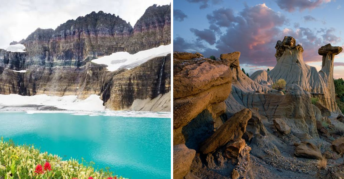
Glacier National Park’s Going-to-the-Sun Road
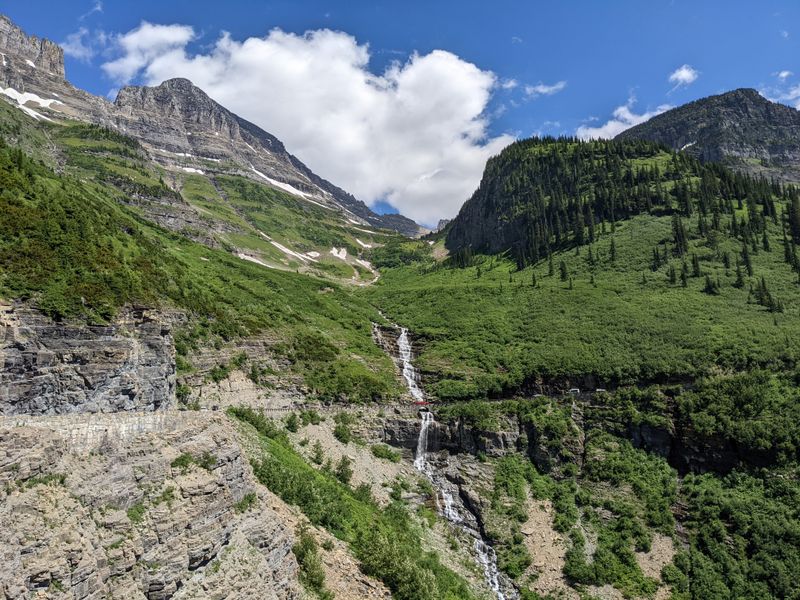
Winding fifty miles through the heart of Glacier National Park, Going-to-the-Sun Road ranks among the most spectacular drives anywhere on Earth.
Engineers spent eleven years carving this masterpiece into mountainsides during the 1920s and 1930s, creating a route that climbs over 3,000 feet to cross the Continental Divide at Logan Pass.
Every hairpin turn reveals another jaw-dropping view of glacial valleys, cascading waterfalls, and peaks that pierce the sky.
Summer visitors can spot mountain goats and bighorn sheep grazing near the roadside, completely unfazed by passing cars.
The road typically opens in late June after crews spend weeks clearing massive snowdrifts, some reaching heights of eighty feet or more.
Pullouts along the route let you stop and soak in panoramas that stretch for miles across wilderness few people ever see up close.
Logan Pass sits at 6,646 feet elevation and serves as the starting point for incredible hiking trails like the Hidden Lake Overlook.
Wildflowers explode in color during July and August, painting alpine meadows in brilliant purples, yellows, and reds.
Bird watchers love spotting Clark’s nutcrackers and white-tailed ptarmigan among the rocks.
Plan your visit for early morning or late afternoon to avoid crowds and catch the best lighting for photography.
The park shuttle system helps reduce traffic congestion during peak season from July through early September.
Bring layers of clothing since temperatures can swing thirty degrees between the valleys and mountain passes.
Snow often lingers into summer at higher elevations, creating stunning contrasts against green forests below.
This engineering marvel earned designation as a National Historic Civil Engineering Landmark in 1985.
Experiencing this road means witnessing human ingenuity harmonizing perfectly with untamed wilderness beauty.
Flathead Lake’s Turquoise Waters
Stretching across 191 square miles in northwest Montana, Flathead Lake claims the title of largest natural freshwater lake west of the Mississippi River.
What makes people gasp isn’t just its size but the unbelievable turquoise color that makes the water look like something from the Caribbean.
Glaciers carved this massive basin thousands of years ago, leaving behind a lake so clear you can see rocks thirty feet below the surface on calm days.
Cherry orchards line portions of the eastern shore, creating a unique agricultural landscape you wouldn’t expect this far north.
Wild Horse Island sits in the middle of the lake and protects a herd of bighorn sheep along with actual wild horses that roam freely.
Kayakers and paddleboarders love exploring the protected bays and coves where the water stays calm even when winds whip across open sections.
Summer transforms the lake into a recreation paradise with sailing, fishing, and swimming drawing visitors from across the region.
Lake trout and yellow perch thrive in these cold waters, making fishing trips productive year-round.
The town of Polson anchors the southern end while charming Bigfork sits at the northeastern corner, both offering great restaurants and lodging.
Sunset watching from the western shore creates magical moments as the Mission Mountains reflect perfectly in still evening waters.
Winter freezes parts of the lake solid enough for ice fishing, though its size means it never completely freezes over.
Wayfarers State Park on the eastern shore provides excellent camping and beach access at 28 North Shore Lane in Bigfork.
Local legend speaks of a lake monster called Flessie, though most visitors are content spotting eagles and ospreys instead.
The Flathead Valley surrounding the lake produces some of Montana’s finest wines and craft beers.
Spending time here reminds you that paradise doesn’t always require tropical temperatures.
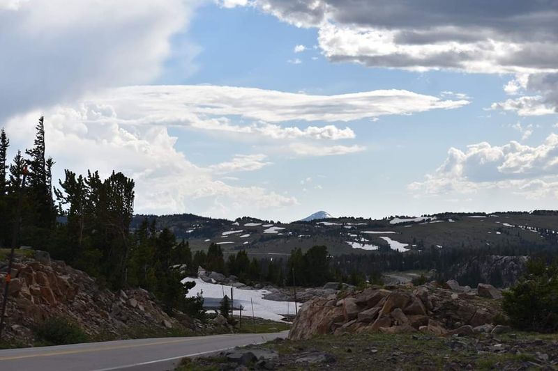
Beartooth Highway’s Alpine Majesty
Charles Kuralt once called the Beartooth Highway “the most beautiful drive in America,” and anyone who’s experienced it understands why he felt that way.
This sixty-eight-mile stretch of U.S. Route 212 climbs from the mountain town of Red Lodge to the northeast entrance of Yellowstone National Park.
Twenty switchbacks carry you up to Beartooth Pass at 10,947 feet, where you’re literally driving through alpine tundra normally reserved for serious mountaineers.
Construction crews needed nine years to complete this engineering wonder, which opened to traffic in 1936.
Snow closes the road from mid-October through late May, making the summer season precious and brief for those wanting to experience its grandeur.
Plateau landscapes at the top feel more like Alaska than Montana, with stunted vegetation and rocks scraped clean by ancient ice.
Dozens of alpine lakes dot the high country, their surfaces reflecting clouds and peaks in mirror-perfect stillness.
Marmots whistle warnings to each other as you hike short trails from various pullouts along the route.
The Top of the World Store sits near the summit, offering snacks and souvenirs at one of the highest elevations any store operates in North America.
Photographers arrive before dawn to catch first light painting the Absaroka-Beartooth Wilderness in golden hues.
Thunderstorms develop quickly at these elevations, so watch weather forecasts and start your drive early in the day.
Fuel up in Red Lodge before ascending since services disappear once you leave town behind.
Wildlife sightings include mountain goats, black bears, and occasionally grizzlies wandering the high meadows.
Rock Creek Vista Point provides one of the most photographed panoramas, showcasing layer upon layer of mountain ranges fading into distant haze.
This highway proves that sometimes the journey really does matter more than the destination.
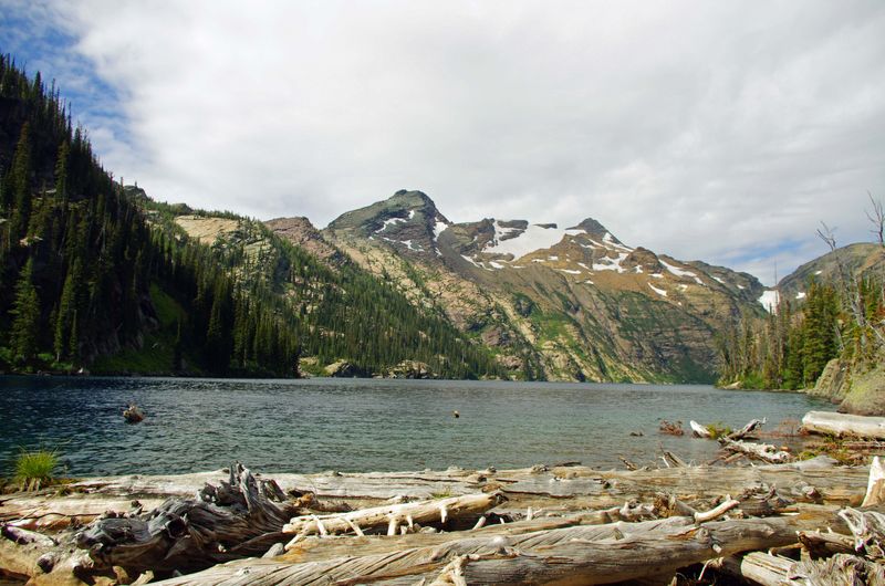
Many Glacier Valley’s Glacial Grandeur
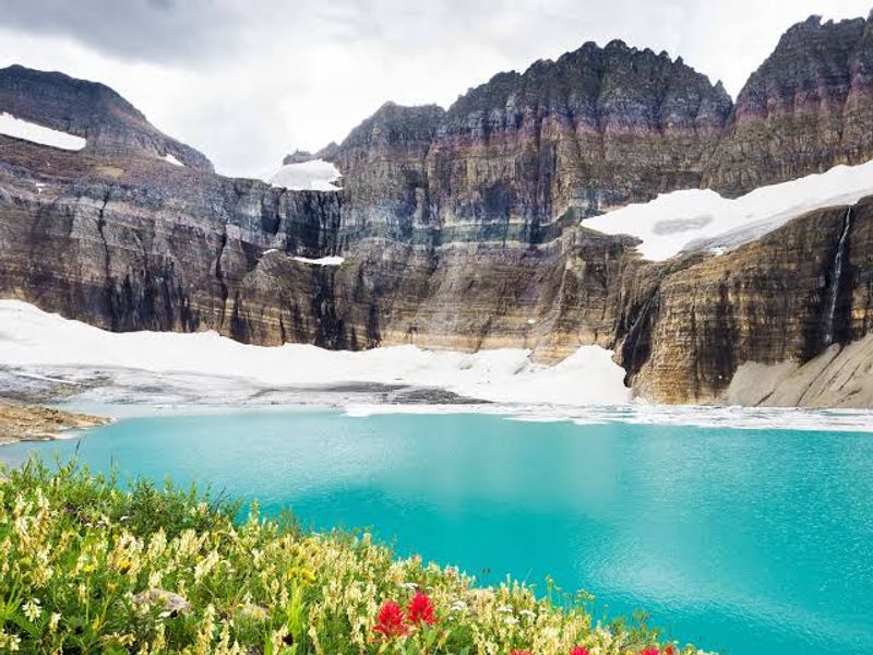
Tucked into the northeastern section of Glacier National Park, Many Glacier Valley delivers concentrated alpine beauty that makes even seasoned travelers stop and stare.
Grinnell Glacier hangs dramatically on the Continental Divide, slowly melting but still clinging to mountainsides where it’s existed for thousands of years.
Swiftcurrent Lake and Lake Josephine sit like jewels in the valley floor, their waters colored by glacial flour that creates otherworldly shades of blue and green.
The historic Many Glacier Hotel opened in 1915 and still welcomes guests seeking old-world charm combined with wilderness access.
Dozens of hiking trails radiate from the valley, ranging from easy lakeside strolls to challenging climbs that reward effort with panoramic views.
Grizzly bears frequently roam the valley, making bear spray and awareness absolutely essential for anyone venturing onto trails.
Photographers consider the valley one of North America’s premier locations for capturing dramatic mountain scenery.
Mount Gould, Mount Wilbur, and Mount Grinnell form an imposing backdrop that changes character throughout the day as light shifts and clouds move.
Wildflower season peaks in July when entire hillsides burst into color with lupine, beargrass, and Indian paintbrush.
Boat tours on Swiftcurrent Lake connect to Lake Josephine, cutting hiking distance for those heading toward Grinnell Glacier.
Moose often feed in willow thickets near the lakes during early morning and evening hours.
The road accessing Many Glacier typically opens in late May, though snow can linger at higher elevations well into summer.
Ptarmigan Falls thunders down a cliff face visible from several trails, creating mist that rainbows form in during sunny afternoons.
Backcountry camping permits let experienced hikers spend multiple days exploring remote areas beyond day-hike range.
Visiting Many Glacier means experiencing Glacier National Park at its absolute most spectacular, where every view seems impossible yet completely real.
Makoshika State Park’s Badlands Beauty
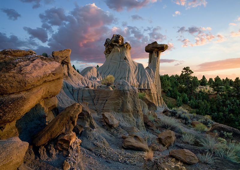
Montana’s largest state park spreads across 11,531 acres of badlands terrain near Glendive in the eastern part of the state.
Makoshika comes from a Lakota phrase meaning “bad earth” or “bad land,” referring to the challenging terrain that early settlers found difficult to cross or farm.
What makes bad land for agriculture creates spectacular scenery for modern visitors, with colorful layers of sedimentary rock eroded into fantastic shapes.
This landscape formed over seventy million years ago when dinosaurs roamed a subtropical floodplain where Montana now exists.
Fossil hunters have discovered numerous dinosaur remains here, including Triceratops and Tyrannosaurus rex specimens.
The park’s interpretive center displays some of these fossils and explains the geology that created this unique environment.
Hiking trails wind through narrow canyons and climb to viewpoints overlooking miles of sculpted badlands.
Juniper trees and ponderosa pines cling to hillsides, somehow finding purchase in what seems like bare rock.
Spring brings green grass and wildflowers that soften the harsh landscape temporarily before summer heat bakes everything brown.
Camping facilities include developed sites with electrical hookups plus primitive areas for those seeking more solitude.
Sunrise and sunset transform the rocks into glowing shades of red, orange, and purple that photographers dream about.
The park sits just a few miles from downtown Glendive, with the entrance located at 1301 Snyder Avenue.
Rattlesnakes inhabit rocky areas, making sturdy boots and awareness important for anyone exploring off main trails.
Bird watchers spot golden eagles, prairie falcons, and turkey vultures riding thermal currents above the badlands.
Visiting Makoshika reveals a completely different side of Montana, proving the state offers way more than just mountains and forests.
Winter visits provide solitude and stark beauty, though icy conditions can make some roads and trails impassable.
Bob Marshall Wilderness Complex
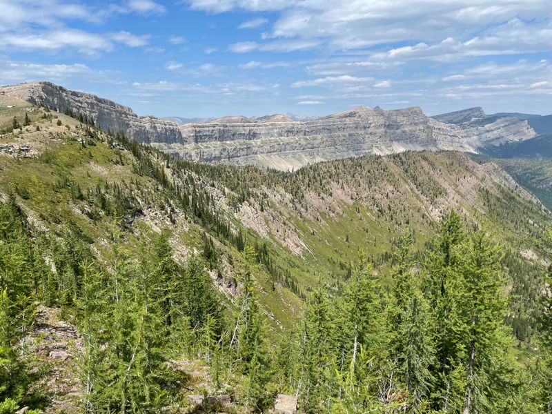
Spanning 1.5 million acres across three contiguous wilderness areas, the Bob Marshall Wilderness Complex represents one of the largest roadless areas in the continental United States.
Locals simply call it “The Bob,” and it’s become legendary among backpackers, horse packers, and anyone seeking true wilderness solitude.
No roads, no cell service, no developments of any kind—just mountains, forests, meadows, and rivers flowing exactly as they have for millennia.
The Chinese Wall formation stretches for twenty-two miles, a massive limestone escarpment rising a thousand feet above the surrounding landscape.
Grizzly bears, wolves, and wolverines roam freely here, making this one of the few places in the Lower 48 where complete predator-prey ecosystems still function.
Hundreds of miles of trails crisscross the wilderness, though navigation skills and self-sufficiency are absolutely required for safe travel.
Most visitors enter the Bob during summer months when snowmelt opens high-country passes and meadows explode with wildflowers.
Outfitters based in towns like Augusta, Choteau, and Seeley Lake offer guided horseback trips for those lacking backcountry experience.
Fishing in remote streams and lakes produces cutthroat trout that have never seen an artificial fly or lure.
Planning a trip requires obtaining wilderness permits, studying maps carefully, and preparing for rapidly changing mountain weather.
The South Fork of the Flathead River forms the western boundary, offering challenging whitewater for experienced rafters.
Autumn transforms aspen groves into golden corridors while bugling elk echo through valleys during the rut.
Named after wilderness advocate Bob Marshall who helped establish the modern wilderness preservation movement, this landscape honors his vision perfectly.
Wildlife biologists study animal populations here because the ecosystem remains largely unaltered by human activity.
Entering the Bob Marshall Wilderness means accepting nature on its own terms, where you’re a temporary visitor in a world that belongs to the wild.
Dear Reader: This page may contain affiliate links which may earn a commission if you click through and make a purchase. Our independent journalism is not influenced by any advertiser or commercial initiative unless it is clearly marked as sponsored content. As travel products change, please be sure to reconfirm all details and stay up to date with current events to ensure a safe and successful trip.