Nevada’s desert keeps secrets that once catered to weary travelers, then slipped into silence when the rush faded. You can still walk boardwalks, peek through hotel windows, and trace rail spurs that promised the next horizon. These towns were waystations and playgrounds for prospectors, freighters, and dreamers, and their bones still point you down the road. Step lightly, bring curiosity, and let the Silver State tell you what it remembers.
1. Rhyolite
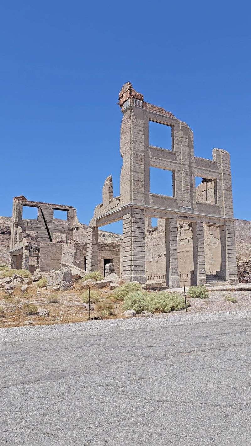
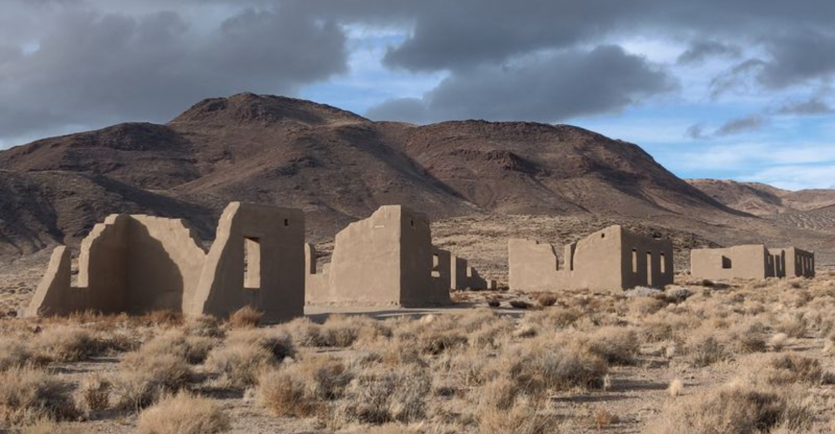
The ruins of Rhyolite sit west of Beatty at Rhyolite Ghost Town Road, Nye County, Nevada, where the depot walls and hotel frames face a basin of sun and grit.
You arrive on a narrow road that once guided travelers from rail cars to lodgings, and the broken bank windows still frame a clear desert sky.
The Bottle House stands patched and curious, a reminder that nothing went to waste when a boomtown needed charm for passersby.
Travelers once stepped off the train, checked into sturdy hotels, and walked to an opera house that promised a night of brightness between hard miles.
Freight wagons rattled past general stores stocked for quick restocking, then drifted toward Death Valley trails with a fresh sense of direction.
Today the sidewalks are fragments, the depot platform a quiet line that points nowhere yet feels like a compass.
Listen for wind sliding through window arches, because the town’s story is told best in that soft, steady breath.
Placards describe the boom and the collapse, and you can follow a self-guided path that charts short lives of big hopes.
You should bring water, good footwear, and time to wander, since the landscape tells its tale slowly and clearly.
Rhyolite’s address anchors you to Nevada, but the view unhooks you from time, offering a rare pause between journeys.
2. Belmont
Belmont rests along Main Street near the historic courthouse in Nye County, Nevada, where brick, timber, and pale hills outline a town that hosted travelers between lodes.
The courthouse stands calm and square, a landmark that once presided over disputes and guided visitors needing papers, directions, or a bed for the night.
Remains of hotels and a music hall flank the street, their thresholds inviting you to imagine suitcases, boots, and hopeful conversations after long rides.
Freighters and prospectors stopped here for supplies, then continued toward remote diggings while the sidewalks echoed with daily chatter.
You can park by the courthouse and walk a short loop that passes stone walls, cellar rooms, and the school site that anchored families.
The breeze smells of sage, and each lot has a story layered beneath the dust and scattered tin.
Belmont guided travelers between mining districts, giving lodging and news in equal measure while stage lines stitched Nevada together.
Scan the horizon and you will see roads that still connect, though they run quieter now and favor slow exploration.
Respect closures, as some structures are fragile, and let your camera linger on textures rather than quick panoramas.
When the mines thinned, the people moved on, yet the town’s simple grid and sturdy courthouse keep pointing the way forward.
3. Berlin
Berlin sits within Berlin Ichthyosaur State Park at 50 Berlin Road, Austin, Nevada, where preserved buildings outline a silver camp that welcomed travelers with beds and news.
The hotel facade faces rolling hills, and a line of cabins climbs the slope like a timeline you can read with your feet.
Interpretive signs describe the boarding life, the saloon culture, and the steady flow of visitors chasing wages and rumors.
You can tour the mill site, pause by the assay office, and trace plank paths that linked miners to passing teamsters.
The park adds a layer of deep time with fossils, turning your stop into a duet of human hustle and ancient sea.
Rangers keep the structures safe, and their routes help you see how a traveler would navigate rooms and corridors.
Bring patience, because the elevation and wind ask you to move slowly and watch shadows cross the shafts.
From the hotel porch, the valley opens like a map, pointing toward other Nevada districts that once traded workers and supplies.
Even now, the layout feels practical, with sightlines that show who arrived, who left, and who lingered.
When the ore quieted, lodging emptied, yet Berlin’s careful preservation lets you walk the lobby again in respectful silence.
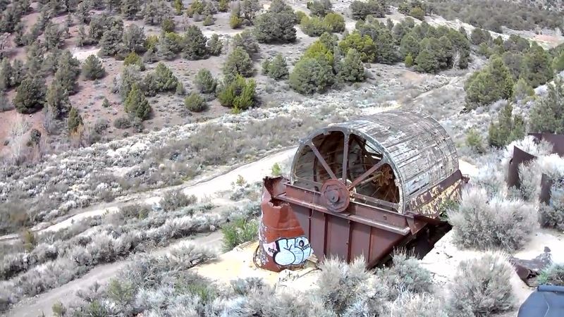
4. Rochester
Rochester clings to a canyon southeast of Lovelock along Rochester Canyon Road, Pershing County, Nevada, where stone walls and rusted frames line a narrow grade.
The approach feels like a story unfolding, with switchbacks that deliver you past tailings, cabin footprints, and a few stubborn timber posts.
This was a stop for prospectors carrying fresh leads, a place to find supplies and trade gossip before pushing deeper into gulches.
The town stretched along the road, so every traveler became part of the main street as hooves and wheels passed doorways.
You will find foundations of businesses that once sold tools, blankets, and lanterns, all arranged for quick turnaround between shifts.
Stand still, and you can almost count the footsteps that shaped the grade into a continuous ribbon of intent.
Look up canyon to see how the light marks hours on the ridge, then check your map because routes split quickly.
Respect private parcels and old shafts, since safety depends on staying aware of rock, iron, and changing weather.
In Nevada, thin air carries sound, so small movements travel far, and your visit becomes a conversation with space.
When the gold ebbed, Rochester emptied, leaving a roadside inn of memory that still greets anyone passing through.
5. Goldfield
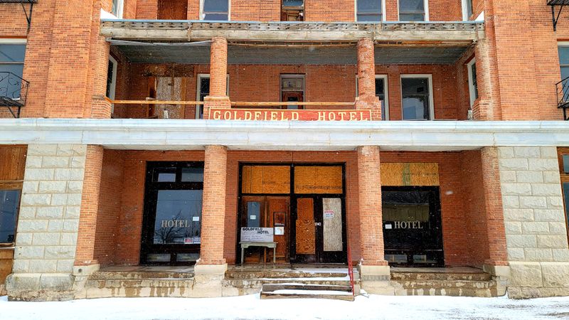
Goldfield’s historic district spans Crook Avenue and Columbia Avenue, Goldfield, Nevada, where grand hotel shells and the courthouse anchor streets made for arrivals.
In the boom years, carriages dropped travelers at lobbies lit by electric light, and porters steered trunks toward polished staircases.
Today, brick and stone still frame the avenue, while interpretive plaques sketch the swift rise and the sudden unraveling.
Visitors can walk block to block and feel how commerce once moved, a steady tide flowing through open doors.
The scale sets Goldfield apart, since the town aimed high and built big enough to catch every wandering ambition.
Even in quieter times, storefronts reflect sky like mirrors, a reminder that appearance guided fortunes as much as ore.
Stop near the courthouse and study its angles, then pivot to see the hotel lines that defined a traveler’s first impression.
Street grids lead out to neighborhoods where boarding houses held workers between shifts and dreams between paydays.
You should tread gently around closed structures, as heritage and safety share the same fragile boundary in Nevada.
Goldfield’s grandeur remains a landmark for road trippers, a place where you can still check in with history.
6. Fort Churchill
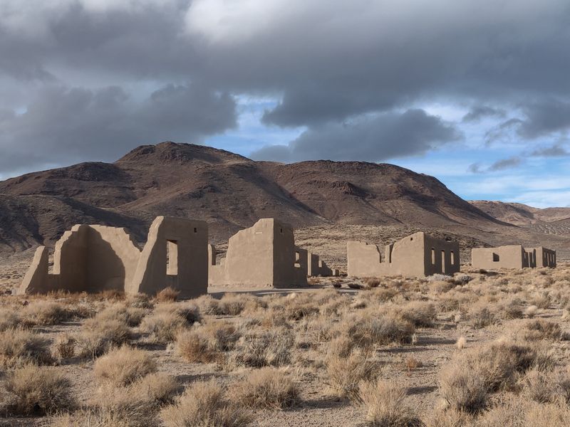
Fort Churchill State Historic Park sits at 10001 US Highway 95 Alternate, Silver Springs, Nevada, where adobe walls outline a military post that guarded travelers and mail routes.
The parade ground is open and quiet, and cottonwoods along the Carson River mark a natural corridor through the desert.
Barracks remains and the commissary give shape to a routine that moved people, horses, and wagons with dependable rhythm.
Interpretive panels describe patrols that escorted stages and settlers, guiding traffic across a wide and contested landscape.
You can walk the loop trail and watch shadows fill the doorways, then step into the visitor center for context.
The fort feels orderly even in ruin, like a calendar laid on the ground with days you can still count.
Travelers relied on this post for security and direction, and the road outside still carries that sense of passage.
Bring respect for the adobe, since one careless touch can undo hours of sun and wind shaping.
Stand near the flagpole site and face west, and the mountains frame a route that still pulls the eye.
Nevada’s history gathers here in one clean line, moving from outpost to memory without losing its purpose.
7. Ione
Ione spreads along Main Street near Ione Valley Road, Nye County, Nevada, with stone storefronts that once stocked gear for travelers bound for nearby camps.
The town worked as a supply hub, so wagons rolled in, loaded up fast, and continued toward scattered diggings across the hills.
Fragments of hotels and offices line the grade, each doorway opening toward a day’s journey and the next water source.
The rhythm made sense in a state with long distances, where a dependable counter and a good map meant everything.
You can follow the old street on foot, tracing cellar outlines and reading the terrain for clues about traffic patterns.
Wind carries grit through the window voids, and the smell of sun on stone feels like an honest welcome.
A small cemetery and outbuildings speak for the families who kept the shelves tidy and the ledger clean.
Take care around pits and shifting walls, because the desert preserves without forgiving, and balance is your ally.
Look back from the hill and the valley stretches wide, a reminder that Ione connected dots across central Nevada.
When the mines around it slowed, the town’s purpose faded, leaving a quiet landmark for modern travelers seeking perspective.
8. Jumbo
Jumbo hides in the hills of Elko County off dirt routes near the Tuscarora region, Nevada, with low walls and scattered timbers marking a brief silver camp.
The site sits high and feels provisional, like a tent that never learned to become a house before the crowd moved on.
Travelers reached it for quick lodging and supplies, then pressed farther into canyons that promised narrow veins and short fortunes.
The road in demands attention, so plan your exit before you lose the sun that draws lines across the sage.
Foundations cluster near the workings, which tells you how the day unfolded, from bunkhouse to face and back again.
Stand by a doorway frame and picture a counter with maps and a tin lamp guiding decisions after dusk.
Jumbo’s ruins are modest, yet they explain how Nevada’s network of traveler stops kept the machine humming.
Do not disturb tailings or timber, because these pieces rest lightly and teach best when left alone.
From the ridge you can see routes running in all directions, which is exactly why people stopped here at all.
The silence is patient, and your footsteps write the latest note in a ledger already full of departures.
9. Palmyra
Palmyra lies near the Como district east of Carson City along access roads off NV-50, Lyon County, Nevada, where terraces and faint foundations trace a small service town.
These slopes supported boarding rooms and supply counters that catered to travelers pushing between mountain camps and valley depots.
The footprint is subtle, so patience helps as you read stone lines and bench cuts that once held busy porches.
Stand above the site and imagine pack trains stacking gear, then following grades that stitch ridgelines together.
The view turns wide and calm, and it becomes clear how a simple stop could anchor a route across the state.
You may spot remnants of corrals and trash scatters, which sketch the everyday chores that kept visitors moving.
Walk softly to avoid disturbing surfaces, because artifacts lie shallow and stories cling to their exact positions.
The wind here carries pine and dust, a mix that smells like work ending and travel beginning.
Palmyra faded when nearby prospects thinned, and the town slipped into the background while roads kept breathing.
What remains is a quiet page where you can write your own line without erasing the old ones.
10. Unionville
Unionville threads along Old Pioneer Garden Road in Pershing County, Nevada, where stone cabins and shaded lanes follow the base of the Humboldt Range.
The settlement served miners and travelers moving along river corridors, offering beds, blacksmith work, and steady information about trails ahead.
Some buildings remain in use nearby, so the ghost edges blur, and respect for residents and property matters.
Walk the street trace and watch how the canyon narrows, funneling traffic toward reliable water and shelter.
Historic markers explain the mining start, the traveler services, and the attrition that pulled people away when prospects cooled.
The rhythm here is softer than in many Nevada sites, a blend of lived-in quiet and remembered bustle.
Look up to the ridgeline and you will see why travelers paused, since weather moves quickly along that spine.
You can park carefully and explore on foot, keeping eyes open for uneven surfaces and signed limits.
Every doorway tells a practical story about rest, repair, and the morning’s departure toward the next chance.
Unionville rewards patience, because the town speaks in small details that add up to a clear map of the past.
Dear Reader: This page may contain affiliate links which may earn a commission if you click through and make a purchase. Our independent journalism is not influenced by any advertiser or commercial initiative unless it is clearly marked as sponsored content. As travel products change, please be sure to reconfirm all details and stay up to date with current events to ensure a safe and successful trip.