Red rocks and dusty plains stretch to the horizon with a silence that feels almost otherworldly. I parked the car and stepped out onto a landscape that looks more like Mars than anywhere on Earth.
Oregon has desert vistas that seem impossible given how close they are to lush forests and rainy coastlines. The rock formations are twisted and colorful with layers of volcanic ash and ancient lava flows frozen in time.
I hiked through a canyon where the walls glowed orange in the late afternoon light like a scene from a space exploration documentary. Oregon really offers a geological wonderland where you can feel like an astronaut without needing a rocket ship or a spacesuit.
The juniper trees are twisted and ancient and the sky stretches wide enough to make you feel very small in the best way. I watched the sunset paint the rocks in shades of purple and pink that no camera could ever fully capture.
The silence is so deep that you can hear your own heartbeat if you stand still for a moment. You leave with red dust on your boots and the strange feeling of having visited another planet for the afternoon.
1. Alvord Desert, Harney County

Standing in the middle of the Alvord Desert feels like someone pressed pause on the entire world. This remote playa sits in the rain shadow of Steens Mountain in Harney County, southeastern Oregon.
The dry lakebed stretches about 12 miles long and 7 miles wide, creating one of the flattest natural surfaces in the state. When it is completely dry, the cracked white earth looks like something you would see in a NASA photograph.
Occasionally, shallow water floods the playa after heavy rains, creating a mirror-like surface that reflects the sky perfectly. The effect is surreal and genuinely breathtaking.
Land sailors and kite buggies love this spot because the flat surface and steady desert winds make for incredible speeds. It is also a favorite for photographers chasing reflections and wide-open compositions.
The nearest town is Fields, Oregon, which is tiny but has a small store known for its burgers and milkshakes. Stock up there because the desert has absolutely nothing in the way of services.
Reaching the Alvord Desert requires driving a gravel road, so a high-clearance vehicle is strongly recommended. The remoteness is part of the magic, and the star-filled night sky here rivals anything you will see in a planetarium.
2. Fort Rock State Natural Area, Lake County

Imagine a giant ring of volcanic rock rising 200 feet out of a flat sagebrush plain, and you start to get a sense of what Fort Rock looks like. This dramatic formation sits in Lake County, about 60 miles south of Bend, Oregon.
Fort Rock is a tuff ring, formed when a volcanic eruption blasted through a shallow lake thousands of years ago. The steam and pressure created this nearly perfect circular wall of rock.
Archaeological evidence found here is remarkable. Scientists discovered sandals made from sagebrush bark inside a cave at Fort Rock, dating back roughly 9,000 years.
That makes them some of the oldest footwear ever found in North America.
A short trail loops around the interior of the formation, giving you an up-close look at the steep volcanic walls. The hike is easy and takes about 30 to 45 minutes at a relaxed pace.
The surrounding flat terrain makes Fort Rock look even more dramatic because there is nothing else competing for your attention on the horizon. Photographers love the clean, uncluttered compositions.
The nearby town of Fort Rock has a small museum worth a quick stop.
3. Crack in the Ground, Christmas Valley

A two-mile-long crack splits the earth open near Christmas Valley in Lake County, Oregon, and it is exactly as dramatic as it sounds. This volcanic fissure is called, simply, Crack in the Ground.
The crack was formed by volcanic activity thousands of years ago when lava flows cooled and the ground shifted apart. In some spots, the walls rise 70 feet high and are only a few feet apart.
The cool thing about hiking inside the crack is the temperature change. Even on a scorching summer day, the narrow passage stays noticeably cooler because sunlight barely reaches the bottom.
The hike through the full length is about four miles round trip and involves some scrambling over rocks. Sturdy shoes are a must because the basalt floor is uneven and can be slippery in spots.
You might find patches of ice surviving deep inside the fissure even well into summer, tucked in corners where the sun never shines. It is a strange and satisfying discovery in the middle of a hot desert.
The area around Christmas Valley is also known for sand dunes, ancient lava fields, and a ghost town nearby. Combining all three into a single day trip makes for a seriously packed and unforgettable adventure.
4. Leslie Gulch, Malheur County

Jagged spires of orange and red rock shoot up from the canyon floor like some kind of ancient fortress built by giants. Leslie Gulch is a remote canyon tucked into Malheur County in far southeastern Oregon.
The formations here are made of rhyolite, a volcanic rock that eroded into wild shapes over thousands of years. The canyon walls rise several hundred feet and create a sense of being completely enclosed in another world.
To get there, you drive about 15 miles of gravel road from the small town of Jordan Valley. The road is passable for most vehicles in dry conditions, but check ahead after any rain.
Hiking trails wind through the canyon and lead to increasingly dramatic viewpoints. The area is also popular with rock climbers who are drawn to the unique volcanic formations.
Wildlife is surprisingly active here. You might spot bighorn sheep scaling the canyon walls or golden eagles circling overhead in the thermals.
Owyhee Reservoir sits at the end of the road, and you can launch a kayak or canoe to explore the flooded canyons by water. The combination of desert rock and blue water creates a color contrast that feels almost unreal.
Camping is primitive and free, which makes this a fantastic budget adventure. The silence at night is so complete that it feels like the rest of the world has simply vanished.
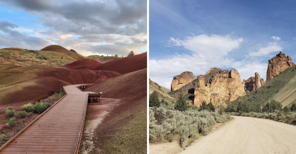
5. Painted Hills, John Day Fossil Beds National Monument

Red, gold, and black stripes wrap around these hills like nature decided to get creative with a paintbrush. The Painted Hills are part of the John Day Fossil Beds National Monument, located near Mitchell in central Oregon.
The colors come from ancient volcanic ash and minerals that built up over millions of years. Each layer tells a different chapter of Earth’s history, going back roughly 35 million years.
The best time to visit is after a light rain, when the clay soils glow with extra intensity. Morning and late afternoon light also make the colors pop in ways that photos barely capture.
You can walk the Painted Hills Overlook Trail, which is a short half-mile loop with stunning views. The Carroll Rim Trail is a longer option for those who want a higher vantage point.
Bring plenty of water because the high desert sun is no joke. There are no food vendors or shops nearby, so pack everything you need before leaving Mitchell.
Camping is available at a small campground near the unit. Staying overnight means you get to watch the colors shift from orange to deep red as the sun sets behind the hills.
6. Owyhee Canyonlands, Malheur County

Few places in the continental United States feel as remote and untouched as the Owyhee Canyonlands in Malheur County, southeastern Oregon. The Owyhee River has spent millions of years carving deep, winding canyons through layers of volcanic rock.
The canyon walls glow in shades of rust, orange, and deep burgundy depending on the time of day. Standing at a rim overlook, the drop feels almost bottomless and the scale is genuinely hard to process.
This is one of the least visited wild places in the entire country. The isolation means you can hike, camp, or float the river for days without seeing another person.
Multi-day rafting trips through the lower Owyhee River are a bucket-list experience for paddlers. The river cuts through narrow slot canyons and opens into broad desert valleys, offering constantly changing scenery.
Getting here requires a serious commitment to dirt roads and navigation. A high-clearance four-wheel-drive vehicle is not optional, it is essential.
Spring is the best season to visit because wildflowers bloom across the canyon rims and the river runs high enough for rafting. Summer heat can be brutal, with temperatures regularly climbing past 100 degrees Fahrenheit.
7. Jordan Craters Lava Field, Malheur County

Dark black lava rock stretches across the landscape at Jordan Craters like the earth forgot to clean up after a very messy volcanic event. This remote lava field sits in Malheur County, about 35 miles north of Jordan Valley, Oregon.
The eruption that created Jordan Craters happened roughly 3,500 years ago, which makes it one of the youngest lava fields in Oregon. On a geological timescale, that is basically yesterday.
The main feature is Coffeepot Crater, a large cinder cone that you can hike up for sweeping views of the lava field and surrounding desert. The walk up is short but the loose cinder makes it feel like hiking on a giant pile of gravel.
Inside the crater, you can peer down into the collapsed bowl and imagine the fiery activity that once filled it. The scale of the eruption becomes real very quickly when you stand at the rim.
Lava tubes wind beneath parts of the field, and some are accessible on foot. Bring a flashlight and watch your step because the openings can be sudden and the edges are sharp.
No entrance fee, no visitor center, and no crowds make this one of the most pure and unfiltered volcanic experiences in the Pacific Northwest. The gravel road access requires a sturdy vehicle.
8. Steens Mountain, Harney County

Rising nearly 9,700 feet above sea level, Steens Mountain is one of the most dramatic fault-block mountains in North America. It towers over Harney County in southeastern Oregon like a geological superstar that never needed to audition.
The eastern face of Steens drops nearly one mile straight down to the Alvord Desert below. That sheer escarpment creates one of the most jaw-dropping vertical landscapes in the entire American West.
Ancient glaciers carved four enormous U-shaped gorges into the western slope. Kiger, Wildhorse, Little Blitzen, and Big Indian Gorges are all accessible by road or trail during the summer months.
The Steens Mountain Loop Road is a 66-mile scenic drive that climbs to the summit and passes through sagebrush steppe, aspen groves, and alpine tundra. The road is typically open from July through October.
Wild horses roam the lower slopes of the mountain, descendants of horses that escaped or were released decades ago. Spotting a band of mustangs trotting across the sagebrush is a moment you will not forget quickly.
Fall is an incredible time to visit because the aspen groves turn brilliant gold and orange, contrasting beautifully with the blue sky and dark basalt rock.
9. Glass Buttes, Lake County

Shiny black volcanic glass covers the hillsides of Glass Buttes, and you are actually allowed to pick some up and take it home. This unique spot sits along Highway 20 in Lake County, about 75 miles southeast of Bend, Oregon.
Glass Buttes are a series of rhyolite domes that contain some of the most diverse obsidian deposits in the world. Alongside classic black obsidian, you can find mahogany, rainbow, silver, and even rare red fire obsidian here.
Native Americans traveled from across the region to collect obsidian from Glass Buttes for thousands of years. The sharp edges made it ideal for crafting arrowheads, knives, and other cutting tools.
The Bureau of Land Management allows visitors to collect up to 25 pounds of obsidian per day for personal, non-commercial use. That is a remarkably generous policy for a rockhounding site.
The hike to the summit is about two miles round trip and gains roughly 700 feet in elevation. Views from the top stretch across miles of high desert basin and range terrain.
Bring gloves when handling the rock because obsidian edges are extraordinarily sharp, sometimes sharper than surgical steel. More than one casual visitor has ended a rockhounding trip with a surprise cut.
10. Succor Creek State Natural Area, Malheur County

Succor Creek winds through a canyon so dramatic and colorful that it genuinely looks like it belongs on another planet. This state natural area sits in Malheur County in far eastern Oregon, not far from the Idaho border.
The canyon walls are made of layered rhyolite and tuff in shades of cream, rust, green, and purple. The colors shift constantly depending on the angle of the sunlight, making every hour feel like a new painting.
Rockhounds absolutely love Succor Creek because the area is rich in thunder eggs, Oregon’s official state rock. These rough-looking spheres hide beautiful crystalline interiors that are revealed only when you crack them open.
The creek itself flows through the bottom of the canyon and supports a surprising amount of wildlife. Deer, wild turkeys, and numerous bird species gather along the water in an otherwise parched landscape.
Camping is available at a small, primitive campground right inside the canyon. Waking up surrounded by those towering multicolored cliffs is an experience that beats any hotel view by a considerable margin.
The road into the canyon is gravel and can get muddy after rain, so check conditions before heading out. A passenger car can usually manage the road in dry weather.
Dear Reader: This page may contain affiliate links which may earn a commission if you click through and make a purchase. Our independent journalism is not influenced by any advertiser or commercial initiative unless it is clearly marked as sponsored content. As travel products change, please be sure to reconfirm all details and stay up to date with current events to ensure a safe and successful trip.