Oregon offers some of the most spectacular road trips in the entire country, with routes that wind through towering forests, along rugged coastlines, and past volcanic peaks that seem to touch the sky.
Whether you’re searching for adventure, natural beauty, or simply a peaceful escape from everyday life, the roads of Oregon deliver experiences that stay with you long after you return home.
From the dramatic Pacific shoreline to the high desert landscapes of the east, each journey reveals a different side of this remarkable state.
Families, solo travelers, and groups of friends all find something magical on these routes, where every turn brings a new photo opportunity and every stop offers a chance to connect with nature.
Planning a road trip through Oregon means preparing for diverse weather, stunning scenery, and countless moments that make you grateful for the open road.
These seven routes have earned their reputation as the best drives in the state, each one offering its own unique blend of natural wonders, charming towns, and unforgettable views.
Pack your bags, fill up your tank, and get ready to explore the highways and byways that showcase Oregon at its absolute finest.
Pacific Coast Scenic Byway
Stretching for 363 miles along the entire Oregon coastline, this legendary drive ranks among the most beautiful coastal routes anywhere in America.
Starting at the Columbia River in the north and ending at the California border in the south, the Pacific Coast Scenic Byway treats travelers to an endless parade of ocean views, sandy beaches, and dramatic rock formations that rise from the surf like ancient sentinels.
Every mile brings something new to marvel at, from tide pools teeming with colorful sea stars to lighthouses perched on windswept headlands.
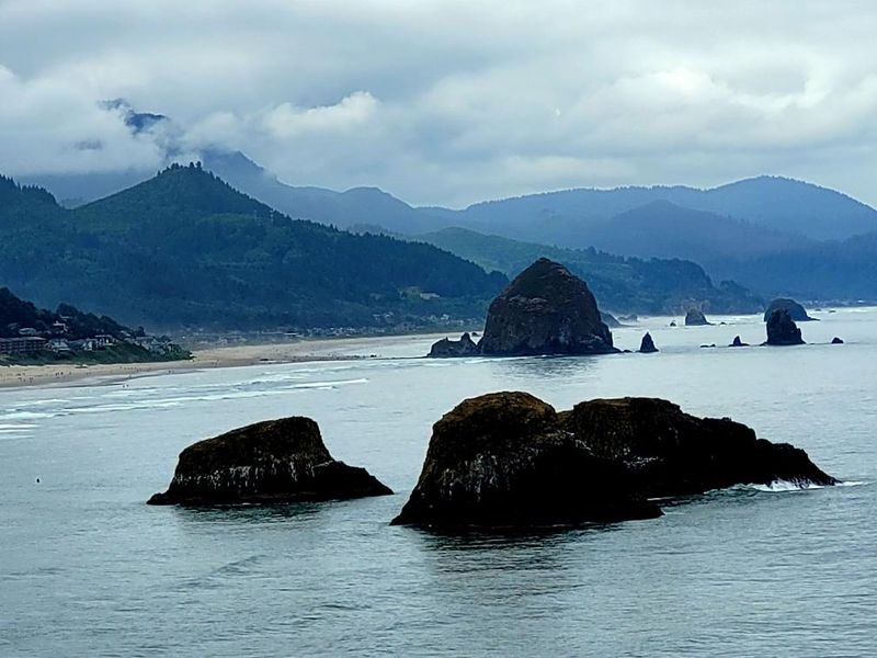
Canon Beach stands out as one of the most photographed spots along the entire route, thanks to Haystack Rock, a 235-foot sea stack that dominates the shoreline at 1588 S Hemlock St, Cannon Beach, OR 97110.
Families love exploring the tide pools around its base during low tide, where hermit crabs scurry between rocks and anemones wave their tentacles in shallow pools.
Further south, the town of Newport offers the Oregon Coast Aquarium at 2820 SE Ferry Slip Rd, Newport, OR 97365, where you can walk through underwater tunnels surrounded by sharks, rays, and thousands of fish.
The Samuel H. Boardman State Scenic Corridor near Brookings presents some of the most jaw-dropping coastal scenery in the entire state, with natural bridges, secret beaches, and viewpoints that make you want to pull over every few hundred feet.
Bring layers of clothing because coastal weather changes quickly, with fog rolling in without warning and temperatures that can vary dramatically throughout the day.
This route demands at least three full days to truly appreciate, though many travelers spend a week or more exploring every hidden cove and charming seaside village along the way.
Crater Lake Rim Drive
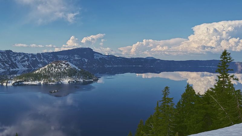
Crater Lake holds the title of deepest lake in the United States, and circling its rim on the 33-mile Rim Drive feels like traveling through a landscape from another planet.
Formed nearly 8,000 years ago when Mount Mazama collapsed after a massive volcanic eruption, the lake’s impossibly blue water reaches depths of 1,943 feet and maintains a clarity that allows you to see objects more than 100 feet below the surface.
The drive typically opens in early July after winter snows melt, though some sections might remain closed until later in summer depending on snowpack.
Starting at Rim Village Visitor Center at Crater Lake National Park, OR 97604, you can gather information about the best viewpoints and short hikes before beginning your clockwise journey around the caldera.
Watchman Overlook offers one of the most spectacular vantage points, especially during sunset when the surrounding cliffs glow orange and pink against the darkening blue water.
The Cleetwood Cove Trail provides the only legal access down to the lake’s edge, a steep 1.1-mile descent that rewards hikers with the chance to touch the famously cold water and even take a boat tour to Wizard Island, the volcanic cinder cone rising from the lake’s western side.
Photography enthusiasts should bring polarizing filters to cut through glare and capture the lake’s true cobalt color, which appears even more vibrant on sunny days.
Snow often lingers along the rim well into summer, creating striking contrasts between white drifts and the blue water below.
Allow at least three to four hours for the complete loop, including stops at overlooks and short walks to viewpoints, though spending a full day exploring the area provides the most rewarding experience of this natural wonder.
Columbia River Gorge Historic Highway
Built between 1913 and 1922, this engineering marvel was designed specifically to showcase the natural beauty of the Columbia River Gorge while providing safe passage through the steep canyon walls.
The historic highway stretches for about 75 miles, though the most scenic sections concentrate between Troutdale and Hood River, where waterfalls tumble from basalt cliffs and viewpoints offer sweeping vistas of the mighty Columbia River carving through the Cascade Range.
Architect Samuel Lancaster designed the road with aesthetics in mind, incorporating stone bridges, graceful curves, and scenic pullouts that feel like works of art themselves.
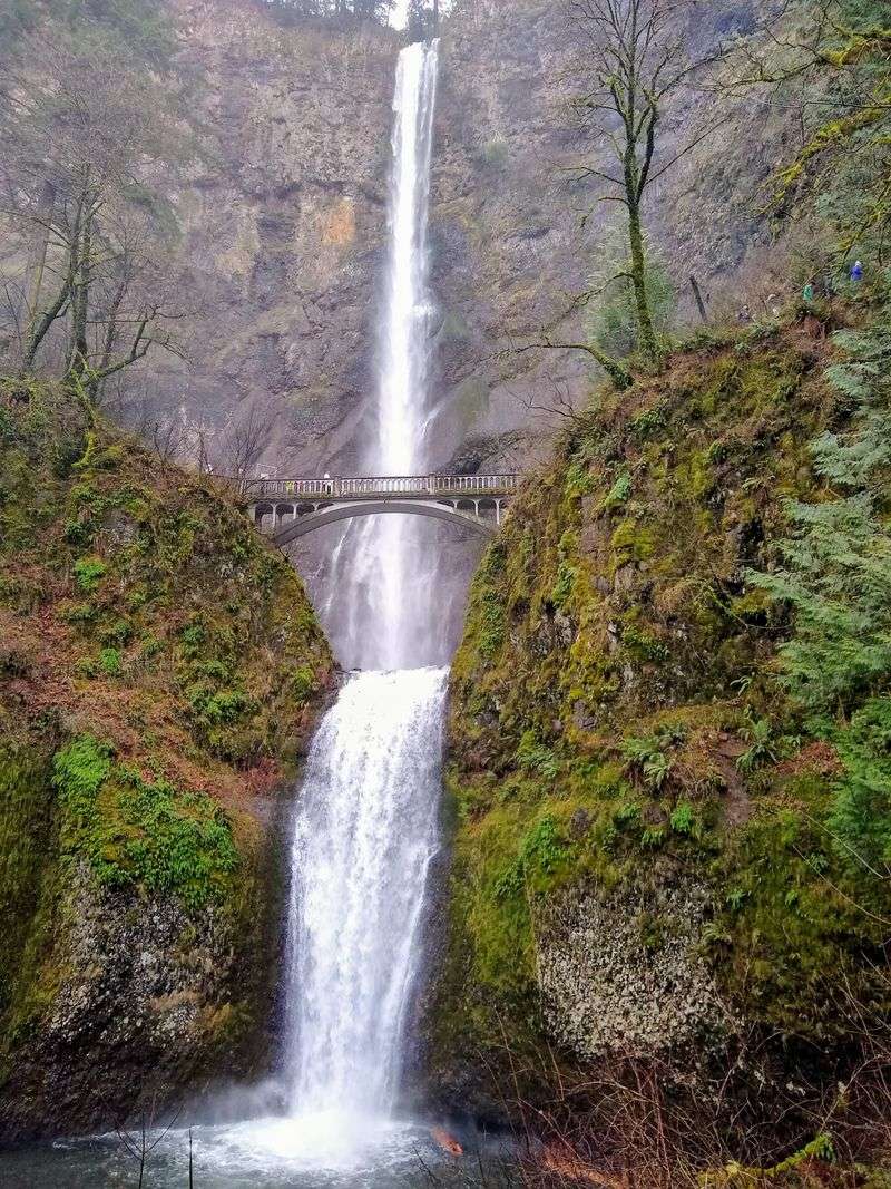
Multnomah Falls stands as the crown jewel of the gorge, plunging 620 feet in two major steps and attracting more than two million visitors annually to its viewing area at 53000 E Historic Columbia River Hwy, Bridal Veil, OR 97010.
A paved trail leads to Benson Bridge, which spans the falls between the upper and lower cascades, offering an up-close encounter with the thundering water and cooling mist.
Latourell Falls, Horsetail Falls, and Wahkeena Falls all provide their own unique character, and many connect through hiking trails that let you visit multiple waterfalls in a single outing.
Vista House at Crown Point State Scenic Corridor sits 733 feet above the Columbia River at 40700 E Historic Columbia River Hwy, Corbett, OR 97019, serving as both an architectural landmark and an observation point with 30-mile views up and down the gorge.
Spring brings the most dramatic waterfall flows as snowmelt swells the streams, though autumn offers spectacular foliage colors and fewer crowds.
The entire historic highway section takes about two hours to drive without stops, but plan for a full day to truly appreciate the waterfalls, viewpoints, and hiking opportunities along this spectacular route.
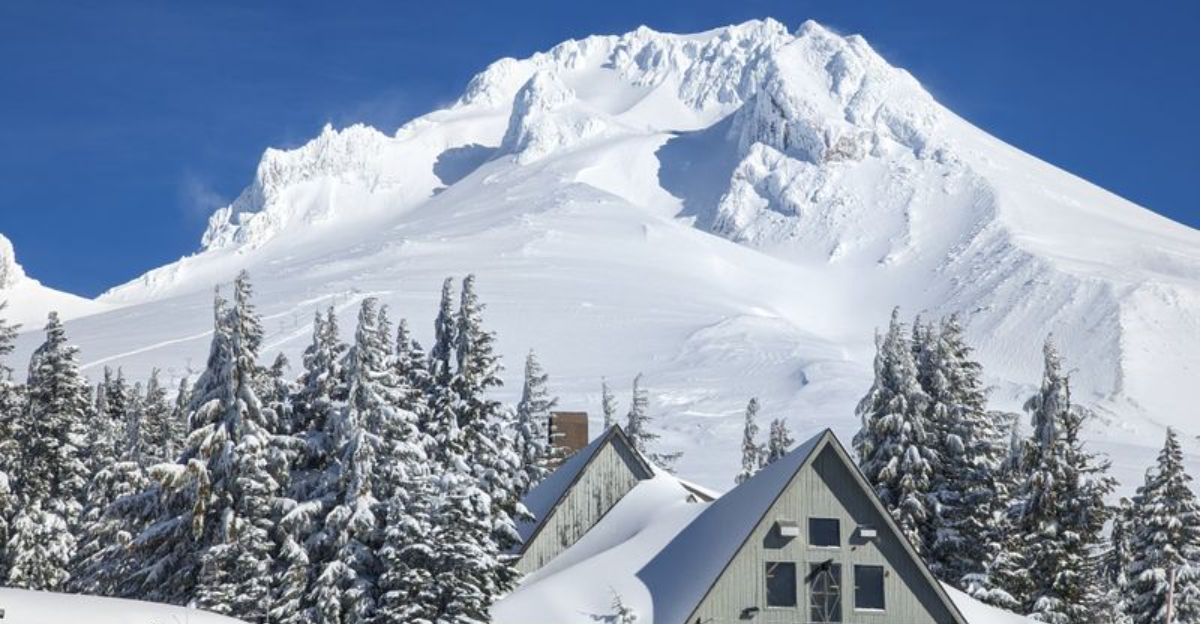
Mount Hood Scenic Byway
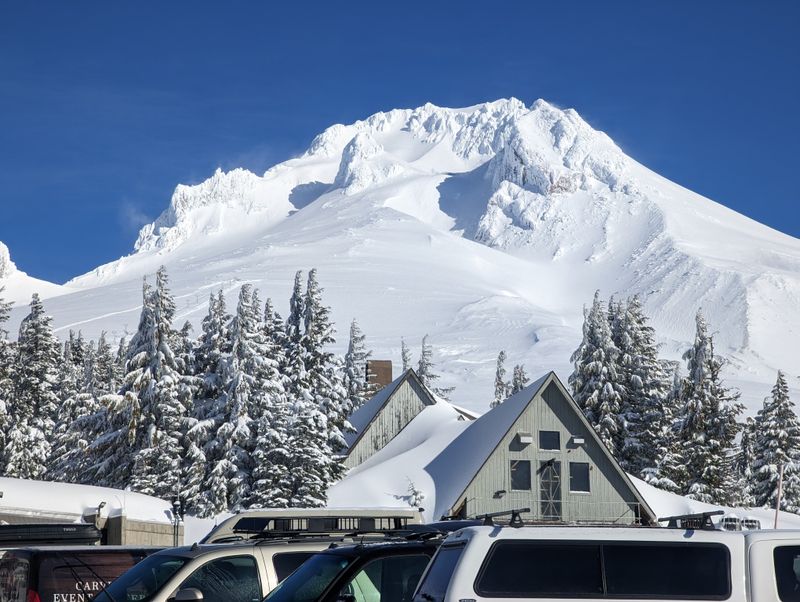
Circling Oregon’s tallest peak, Mount Hood rises 11,250 feet above sea level and dominates the skyline from every angle along this 105-mile loop.
The byway passes through dense forests of Douglas fir and western hemlock, alongside rushing rivers perfect for summer swimming, and past ski resorts that transform into mountain biking and hiking destinations when the snow melts.
Starting from the town of Hood River, the route follows Highway 35 south before connecting with Highway 26 to complete the loop, offering constant views of the mountain’s glaciated slopes and rocky summit.
Timberline Lodge at 27500 E Timberline Rd, Government Camp, OR 97028 stands as a National Historic Landmark built during the Great Depression by skilled craftspeople who created a masterpiece of rustic architecture.
The lodge sits at 6,000 feet elevation and serves as a year-round destination where you can ski even in summer on the Palmer Glacier, enjoy hearty meals with mountain views, or simply admire the hand-carved woodwork and wrought-iron details throughout the building.
The short hike from the lodge to Silcox Hut takes you higher up the mountain for even more spectacular panoramic views of the Cascades stretching south toward California.
Lost Lake Resort at 35000 Lost Lake Rd, Hood River, OR 97041 provides one of the most photographed views of Mount Hood, with the peak perfectly reflected in the calm waters during early morning hours.
Autumn transforms the route into a tunnel of gold and orange as vine maples and cottonwoods change color, creating stunning contrasts against the evergreen forests.
Fruit stands dot the northern section near Hood River during late summer, offering fresh cherries, peaches, and apples from the orchards that thrive in the valley’s fertile volcanic soil, making this drive a feast for all the senses throughout the year.
Journey Through Time Scenic Byway
Few travelers realize that Oregon’s eastern half offers landscapes completely different from the rainy forests and coastal scenes most people associate with the state.
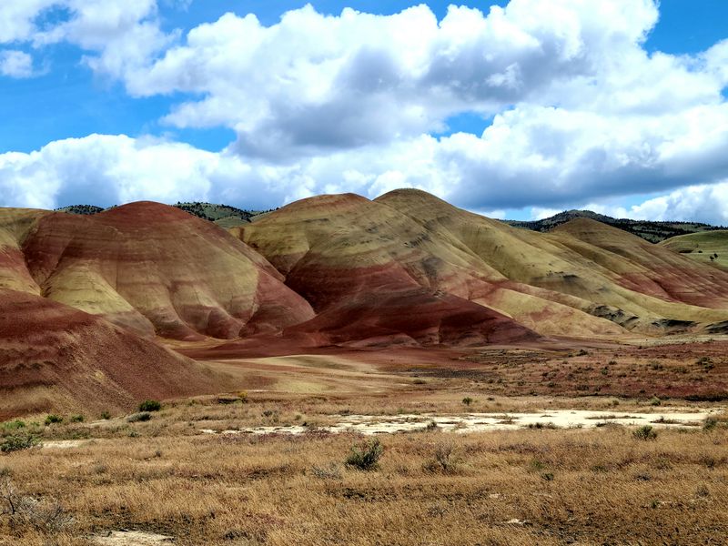
The Journey Through Time Scenic Byway stretches for 286 miles through the high desert country of eastern Oregon, where painted hills display bands of red, gold, and black minerals, fossil beds preserve ancient life from millions of years ago, and wide-open spaces create a sense of freedom found nowhere else.
This route follows Highway 26 from Prineville through Mitchell, Dayville, and all the way to Baker City, traversing terrain that looks more like the American Southwest than the Pacific Northwest.
The Painted Hills Unit of John Day Fossil Beds National Monument showcases hills striped with vivid colors created by volcanic ash weathering over millions of years, with the best viewing at the Painted Hills Overlook Trail at 96550 Burnt Ranch Rd, Mitchell, OR 97750.
Different seasons and lighting conditions change the appearance of the hills dramatically, with late afternoon sun intensifying the reds and golds while morning light brings out subtler shades.
The Thomas Condon Paleontology Center at 32651 Highway 19, Kimberly, OR 97848 displays fossils of ancient horses, camels, and saber-toothed cats that once roamed this region when it was a lush subtropical forest rather than the arid landscape you see today.
Small towns along the route offer genuine Western hospitality, with local diners serving hearty breakfasts and cafes providing welcome rest stops in the vast spaces between settlements.
Summer temperatures can exceed 100 degrees, so carry plenty of water and check your vehicle before starting this remote drive.
The complete journey takes about six hours of straight driving, but rushing through misses the point of experiencing these ancient landscapes that tell the story of Oregon’s geological history spanning millions of years.
McKenzie Pass-Santiam Pass Scenic Byway
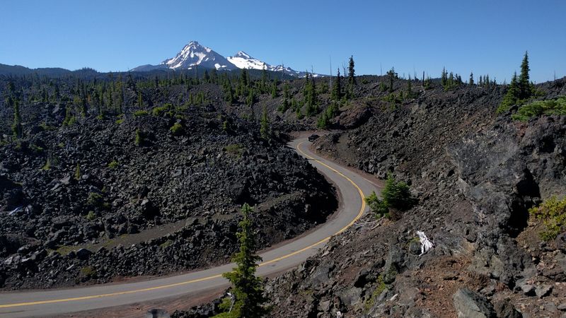
Crossing the spine of the Cascade Range, this 82-mile route takes you through some of the most dramatic volcanic landscapes in the Pacific Northwest.
The byway connects the lush Willamette Valley with the dry eastern slopes of the Cascades, passing through old-growth forests, across vast lava fields that look like frozen black oceans, and past mountain lakes so clear you can count rocks on the bottom.
Highway 242 over McKenzie Pass typically closes from November through June due to heavy snowfall, but when open, it provides an unforgettable journey through terrain shaped by volcanic eruptions as recent as 1,500 years ago.
Dee Wright Observatory sits at the summit of McKenzie Pass at milepost 64 on Highway 242, constructed from lava rock in 1935 by the Civilian Conservation Corps.
The short paved trail around the observatory winds through the lava fields, with windows in the stone structure perfectly framing views of Mount Washington, Three Fingered Jack, and Mount Jefferson.
Sahalie and Koosah Falls along Highway 126 near milepost 5 showcase the power of the McKenzie River as it plunges over ancient lava flows, with easy trails connecting both waterfalls through moss-draped old-growth forest that feels primeval and mysterious.
Clear Lake at 66600 Clear Lake Rd, McKenzie Bridge, OR 97413 maintains a constant 34-degree temperature year-round, fed by springs that keep the water incredibly transparent.
Rent a kayak or canoe to paddle across the lake and peer down at the submerged forest preserved in the cold water, trees that were drowned when a lava flow dammed the McKenzie River about 3,000 years ago.
The Santiam Pass section follows Highway 20 and remains open year-round, offering winter access to snow sports and summer opportunities to explore wildflower meadows that bloom with lupine, paintbrush, and countless other species throughout July and August.
Hells Canyon Scenic Byway

Hells Canyon plunges deeper than the Grand Canyon, dropping 8,000 feet from the peaks of the Seven Devils Mountains to the Snake River far below.
This remote 218-mile loop through northeastern Oregon follows Highway 86 and Forest Road 39, delivering some of the most extreme and dramatic scenery in the entire state.
The byway requires careful planning because services are sparse, some sections involve gravel roads, and winter closures affect the higher elevations, but adventurous travelers who make the journey discover a landscape of raw power and stunning beauty that few people ever witness.
Starting from Baker City, the route heads east through the historic gold mining town of Halfway before climbing into the Wallowa-Whitman National Forest.
Hells Canyon Overlook provides the most accessible viewpoint, located about 30 miles from Highway 86 on Forest Road 39, where you can gaze down into North America’s deepest river gorge and watch eagles soaring on thermal currents far below your vantage point.
The Snake River carves the border between Oregon and Idaho at the canyon’s bottom, and jet boat tours from Hells Canyon Dam offer a completely different perspective as you travel through the narrow gorge with sheer walls rising thousands of feet on both sides.
Wildflowers paint the canyon slopes with brilliant colors during spring, while autumn brings golden aspens and cooler temperatures perfect for hiking.
The Wallowa Mountains to the north present opportunities for side trips, with the charming town of Joseph offering art galleries and bronze foundries at 400 N Main St, Joseph, OR 97846.
This challenging drive demands a full day or preferably two to complete safely, with camping options along the route for those who want to experience the profound silence and star-filled skies that come with this remote corner of Oregon far from city lights and crowds.
Dear Reader: This page may contain affiliate links which may earn a commission if you click through and make a purchase. Our independent journalism is not influenced by any advertiser or commercial initiative unless it is clearly marked as sponsored content. As travel products change, please be sure to reconfirm all details and stay up to date with current events to ensure a safe and successful trip.