Oregon rewards curiosity with landscapes that shift from sapphire lakes to sea swept headlands, and every turn invites a new story.
You will find trails that challenge your legs and viewpoints that quiet your thoughts, often on the same day.
I planned this guide to help you pick unforgettable routes, safe choices, and moments that feel worth the miles.
Expect practical details, current insights, and ideas you can act on today.
Pack layers, charge your camera, and let this list lead you to the good stuff.
Disclaimer: This list of outdoor adventures is based on tourism trends, local insights, and publicly available data at the time of writing. Experiences may vary by season, visitor perspective, and resident views, making the list inevitably subjective.
1. Explore Crater Lake National Park, 570 Rim Village Dr Crater Lake, OR 97604
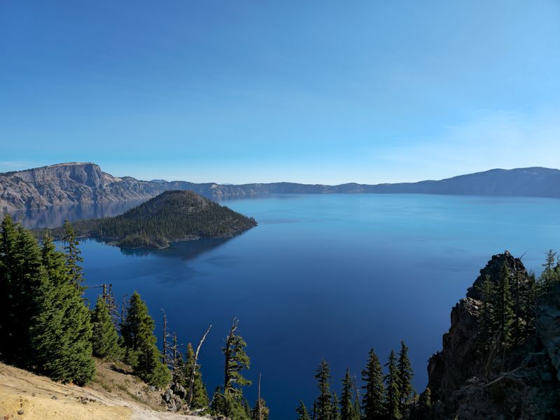
Crater Lake looks unreal at first glance, with that deep blue circle set inside a steep rim of volcanic rock that glows in clean morning light.
Rim Drive usually opens in stages as snowplows clear drifts, so planning around current conditions helps you avoid closures and makes your loop efficient.
Pullouts arrive fast and often, and each turnout frames Wizard Island differently, which keeps the drive fresh and rewards frequent short stops.
Bring layers even in July because wind sweeps across the caldera and the temperature can drop quickly during cloud breaks after warm midday periods.
The Cleetwood Cove Trail is the only legal lake access, and the descent feels easy until gravity reverses and you face the steep climb back up.
Expect volcanic gravel underfoot that rolls like marbles, so sturdy shoes with good tread earn their place on the packing list.
Summer boat tours sometimes operate from the dock below, and schedules can change with water levels, staffing, and maintenance updates.
Photographers chase first light at Discovery Point for calm reflections, then pivot to Watchman Overlook before crowds spike late morning.
Wildflowers dot pumice slopes in July and August, while October can bring crystal air and gold light before the first real storms arrive.
Winter visits trade the drive for snowshoe routes, and ranger led walks offer safe introductions to rim travel and avalanche awareness.
Day visitors often underestimate elevation, so drink water regularly and pace your laps along the rim to avoid afternoon fatigue.
Fuel and services are limited, and cell coverage is patchy, which means offline maps and a full tank simplify the entire experience.
Crater Lake National Park sits in southern Oregon, and its remote setting gives nights a silence that pairs with surreal star fields.
Pack out every wrapper and stick to signed trails because the volcanic soils are fragile and slow to heal from stray footsteps.
Leave time for one last overlook at sunset when the crater rim warms to copper tones and the water darkens to an inky mirror.
2. Hike the Trail of Ten Falls at Silver Falls State Park, 20024 Silver Falls Hwy SE Sublimity, OR 97385

The Trail of Ten Falls strings together a dream list of cascades that feel both grand and intimate as you weave through canyons and mossy amphitheaters.
South Falls sets the tone first with a wide plunge and the famed path that slips behind the veil, which thrills without feeling risky when you move mindfully.
Spray can slick the basalt, so step carefully and keep electronics tucked away when gusts push mist into the alcove behind the falls.
The full loop stretches about eight to nine miles depending on spurs, and moderate grades make it approachable for fit hikers who pace their breaks.
Signage guides you toward Lower South, Middle North, and North Falls, and each stop offers different angles that keep your camera curious.
Large Douglas firs and bigleaf maples filter light into a green hush that turns noon glare into soft glow on water and ferns.
In winter the volume surges and the ambience grows thunderous, while spring brings bright greens and steady flow that feels cinematic without crowds.
Summer is drier and warmer, yet shade lingers along canyon walls, and late day light paints warm tones across spray and lichen.
Parking fills early on weekends, so a dawn arrival secures a calmer path and leaves you time to linger at favorite overlooks.
Keep dogs off sections where rules restrict access for safety and wildlife, and always pack out waste to protect this popular loop.
Maps at trailheads make quick planning easy, and junction markers reassure you when side paths tempt with extra views.
Silver Falls State Park lies within the foothills of the Oregon Cascades, which means weather turns fast and layers prove useful year round.
Cell coverage fades inside the canyon, so screenshot maps and note mileage between major waterfalls before you descend.
Bring a microfiber cloth to clear lenses, since mist can fog glass during long exposures and behind the falls moments.
Finish the loop with quiet time at North Falls where the cavern frames forest like a living curtain and you feel tiny in the best way.
3. Hike or Climb at Smith Rock State Park, OR 97760
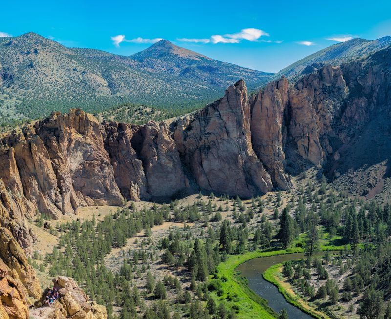
Smith Rock rises above the Crooked River like a stone fortress, and the warm desert light turns the cliffs into layered gold during the last hour of day.
Misery Ridge earns its name with a steep ascent that rewards you with sweeping views of Monkey Face and the Cascades lined up on the western horizon.
The trail surface mixes dust and rock, so poles can help on the descent where quads protest and your footing needs attention.
Climbers flock to classic routes on welded tuff and basalt, and local guide services offer instruction for newcomers who want a safe introduction.
Morning shade makes early laps comfortable, while afternoons feel hot even in shoulder seasons because the high desert holds heat.
Carry water because fountains are limited near the main area, and refill when you can before tackling longer loops across the river.
Photographers chase reflections along calm river bends and use compression from longer lenses to stack spires against snowy volcanoes.
Wildlife sightings include golden eagles and mule deer, and designated raptor closures protect nests during sensitive months each spring.
Camping at the walk in bivy keeps you close to trailheads, yet quiet hours protect the mellow mood and stargazing under clear skies.
Trails like River, Mesa Verde, and Summit add variety if you want mileage without the steep grind of Misery Ridge every time.
Winter days can shine with crisp air and empty paths, though icy patches hide in shade and call for caution on narrow sections.
The park sits in central Oregon near Terrebonne, which makes it a convenient day trip from Bend with plenty of post hike dining options.
Leave no trace habits matter here because cryptobiotic soils are delicate and take years to recover from stray footsteps.
Check current parking rules and day use fees since the lot fills quickly, and overflow requires patience during prime weekends.
Wrap the day with sunset at the footbridge where the river catches color and the cliffs glow like embers as the air cools.
4. Visit Multnomah Falls, 53000 E Historic Columbia River Hwy Corbett, OR 97019
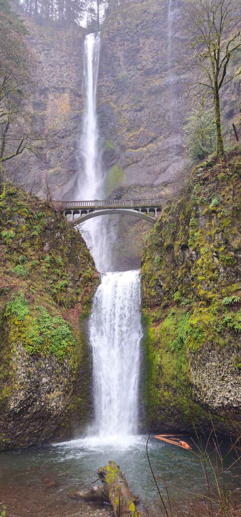
Multnomah Falls feels iconic for good reason, since the twin drop adds drama that very few roadside views can match in any season.
Benson Bridge floats between the tiers like a balcony, and standing there lets you feel the cool spray as the upper falls roars past your shoulder.
The paved path continues above the bridge to a series of switchbacks that climb to a railing at the very top of the falls.
Timed use requirements and parking reservations sometimes apply during busy months, so check the official site before you head into the gorge.
Mornings are calmer and easier for photos because crowds thicken quickly and mid day glare can wash out detail on bright rock.
Water flow peaks during late winter and spring storms, and the mood shifts to a softer hush in late summer as levels drop.
The base plaza includes interpretive signs that outline geology and early tourism, and they provide helpful context for the grand view.
Trails around the area connect to longer routes, and you can link viewpoints if you want more miles without moving the car.
Wear shoes with grip since mist can slick pavement, especially near the base where spray curls back on breezy days.
Cell service varies through the Columbia River Gorge, so download maps before you enter tree covered segments of the historic highway.
Storm damage has closed segments at times in recent years, and updates can shift weekly as repairs progress and hazards are assessed.
Multnomah Falls sits in northern Oregon and anchors many first trips, which makes planning ahead the key to a smooth visit.
Spring wildflowers color nearby slopes, while autumn brushes bigleaf maples with gold that frames the falls in seasonal contrast.
Stay on signed paths to protect fragile plants and to keep rescue crews free for true emergencies in this busy corridor.
End your stop with one last look from Benson Bridge where the gorge breaths cool air and the sound drowns your to do list.
5. Drive the Samuel H. Boardman State Scenic Corridor, US-101, Brookings, OR 97415
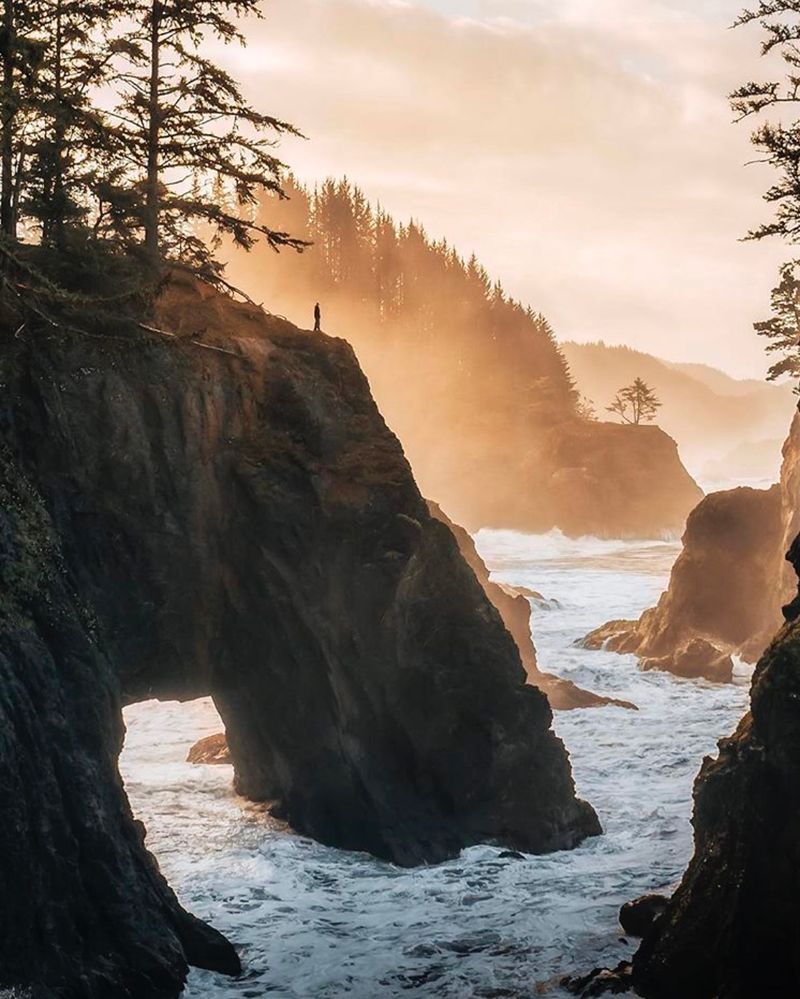
The Samuel H. Boardman State Scenic Corridor strings quiet pullouts along a wild stretch of the southern Oregon coast where cliffs plunge into green water.
Natural Bridges is the headliner viewpoint, and the official overlook gives a safe and satisfying view without risky scrambling onto unstable rock.
Whaleshead Beach offers easy access and a broad arc of sand with views toward sea stacks that look different as tides rise and fall.
Short trails lead to Arch Rock and Indian Sands, and each stop packs a distinct mood that keeps the day feeling varied and unhurried.
Fog can arrive suddenly even on a sunny forecast, which adds atmosphere to photos and keeps temperatures cool for hiking.
Late afternoon light paints the forest edges warm and sets sparkles on the water as waves blow apart on offshore rocks.
Bring a wind shell because gusts lift grit from dry paths and turn exposed viewpoints chilly when the marine layer thickens.
Cell service is spotty and pullouts appear quickly, so move slowly and avoid abrupt turns when traffic hides behind curves.
Tide charts help you time beach walks and reveal hidden coves that sit dry for an hour before the ocean folds back over them.
Sea birds nest on isolated ledges, and keeping distance protects sensitive species that rely on quiet cliffs to raise chicks.
Photography thrives here with long lenses for stacks and wide frames for sweeping skylines that stack forest against bright surf.
This corridor sits near Brookings close to the California border, and it showcases a rugged version of Oregon that feels almost tropical in color.
Benches at roadside stops invite slow moments, which makes the route a pleasure even if you only walk a few minutes each time.
Leave no trace principles matter on crumbly slopes where footsteps accelerate erosion and undercut roots along the edge.
End the drive at sunset when the ocean turns bronze and the stacks silhouette like chess pieces across the glowing horizon.
6. Explore the Oregon Dunes National Recreation Area, 855 Highway 101 Reedsport, OR 97467
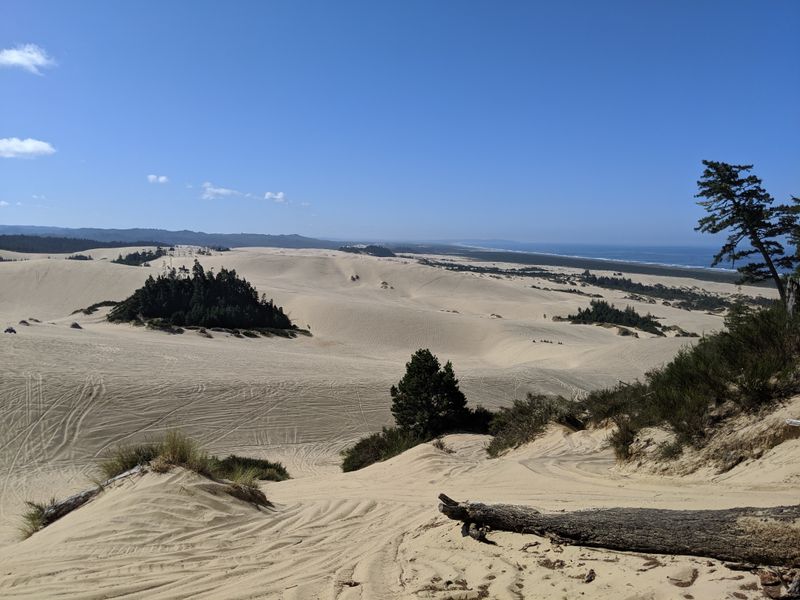
The Oregon Dunes roll for miles between forest and surf, a shifting playground where wind carves knife edges that glow at sunrise and sunset.
Designated motorized areas welcome ATVs and buggies, while quiet zones reserve space for hikers who prefer the hush of sand and wind.
Sandboarding thrives on leeward faces, and waxed boards make short climbs worth the ride as you surf smooth lines to the flats.
Near Florence and Reedsport you can mix short trails with tall dune climbs that present ocean views when you crest the highest ridges.
Permits vary by activity, so check current rules for riding areas and seasonal restrictions that protect wildlife habitat and vegetation.
Foot travel demands patience because every step sinks, which slows pace and turns a two mile loop into a genuine workout.
Foggy mornings soften contrasts and keep temperatures easy, while sunny afternoons can feel hot when the wind drops.
Bring sunglasses with side coverage since sand lifts on gusts and stings when it whips into your eyes at ridge tops.
Trails like John Dellenback Dunes offer clear markers that prevent disorientation, and a compass or GPS helps on wide open sections.
Coastal storms reshape bowls and erase tracks, which gives returning visitors new lines and fresh photos after each windy night.
Water and snacks matter more than usual because dry air and reflected light increase thirst even on cool days.
Footprints fade quickly, yet stay off sensitive plants that anchor dunes and prevent blowouts along the edges of shrub zones.
The recreation area spans a long swath of the central Oregon coast, which means you can sample multiple trailheads in one weekend.
Sunsets deliver pink and gold across ripples that look like silk fabric laid over rolling hills, a perfect time for wide frames.
Wrap up by brushing gear before driving away so sand does not creep into car seals and camera mounts for weeks.
7. Summit South Sister, Cascades Lakes Highway (NF-46) Bend, OR 97701

South Sister draws strong hikers with a straightforward yet taxing climb that stacks elevation relentlessly from trailhead to crater rim.
Most start at the Devil’s Lake Trailhead before dawn, using headlamps to cover forest miles and reach open slopes for sunrise colors.
The route transitions from dirt to cinder to gritty pumice, which feels like walking on ball bearings during the steeper upper switchbacks.
Snowfields can linger into late summer, and microspikes help on firm morning crust while trekking poles assist tired legs on descent.
Altitude gains fast and hydration becomes a deciding factor for comfort, so drink steadily and snack before hunger catches up.
Weather shifts quickly over the Oregon Cascades, and thunder threats mean turnaround decisions that favor safety over summit fever.
The crater hosts a small lake late in season, and the rim delivers sweeping views of Middle and North Sister along with Broken Top.
Leave early for parking and to avoid the soft afternoon surface that turns each step into a sliding effort on loose cinders.
Permits and entry rules change, so confirm current requirements for day use and wilderness quotas before locking plans.
Layering works best because the wind knifes across open slopes even on warm days and chills sweat during snack stops.
Navigation is simple in clear weather, yet whiteouts have fooled parties, which makes a GPS track and map a smart backup.
Footing improves with deliberate cadence, and small steps conserve energy better than bursts that spike your heart rate.
The descent taxes knees, and many hikers prefer gaiters to keep grit from chewing up socks on the long return.
South Sister stands among the tallest peaks in Oregon, so treat it like an alpine climb even if the trail looks straightforward.
Return to the lakeshore for a final view where evening light washes the summit in pastel and the forest begins to hum.
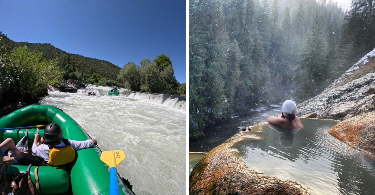
8. Soak in Umpqua Hot Springs, Trailhead Hot Springs Road (NF-3401) Idleyld Park, OR 97447

Umpqua Hot Springs sits above the North Umpqua River on a forested slope where steam rises in cool air and the water layers into terraced pools.
A short but steep trail leads from the parking area to the springs, and the final approach can feel slick after rain or frost.
Temperatures vary by pool, so test with a hand first and choose a spot that feels comfortable rather than chasing the hottest water.
Early mornings deliver quiet soaks and better chances for a clean experience before day traffic brings noise and stirred sediment.
Clothing norms range from swimsuits to natural soaking, and a towel plus sandals make transitions on wet rock more secure.
Pack out everything, including fruit peels and bandages, because animals tear open trash and spread it down the steep hillside.
Seasonal closures can occur due to fire impacts or maintenance, so confirm access with the forest service before making a long drive.
Winter visits feel magical when snow rims the pools, yet traction matters on icy steps and trail edges under shaded trees.
Algae can be slippery, and slow, deliberate movement keeps falls from ruining the easy pace this spot promises.
Water quality fluctuates in any natural spring, so avoid submerging your head and give other visitors plenty of space between pools.
Parking is limited and narrow, which makes carpooling a considerate option on busy weekends when turnout fills before noon.
Bring a change of warm layers because the air chills quickly when clouds move along the river valley.
The drive follows a scenic corridor through southern Oregon, and roadside viewpoints make pleasant stops if the springs are crowded.
Respect quiet hours and keep voices low so the forest soundtrack remains the main presence during your soak.
Leave the place cleaner than you found it and the next traveler will feel the same calm you were lucky to enjoy.
9. Stroll Ecola State Park and Cannon Beach, OR 97110

Ecola State Park offers a graceful mix of old growth forest and grand coastal overlooks that sweep south toward Cannon Beach and Haystack Rock.
Short trails wander through Sitka spruce and salal before emerging at viewpoints where gulls wheel over surf and offshore rocks sparkle.
Indian Beach draws surfers and tide pool explorers, while hikers link mellow paths that thread through shaded draws and open headlands.
Closures sometimes affect sections due to landslides or maintenance, so check recent updates before committing to longer routes.
Fog can drift in fast, but it adds mood to photos and keeps temperatures comfortable while you move between viewpoints.
Whale sightings surprise visitors in spring and late fall, especially from higher perches where the angle helps you catch spouts.
Haystack Rock dominates the southern view and becomes a beacon as you trace the coastline from one fenced overlook to the next.
Morning or late evening light flatters the cliffs and turns damp trails into glowing lines that lead your eye across the frame.
Parking areas fill early on sunny days, so patience and a backup plan help maintain a relaxed rhythm to your outing.
Restrooms and signed picnic areas make family visits easy, and clear rules protect wildlife during peak nesting seasons.
The nearby town of Cannon Beach offers galleries and easy strolling, which pairs well with a slow paced park visit.
Trails can be muddy after rain, so waterproof footwear earns its place and keeps the rest of your gear dry and comfortable.
The park showcases a classic slice of Oregon coast scenery, yet it feels uncrowded when you wander a few minutes beyond the main lots.
Stay behind barriers on cliff edges because soil can undercut and fail without warning near storm damaged sections.
Plan a final stop at a high overlook where the ocean breathes steadily and the forest smells sharp and clean after mist.
10. Raft or Kayak the Rogue River, OR 97527

The Rogue River invites adventure with a blend of splashy rapids, calm pools, and forested bends that feel remote within minutes of pushing off.
Guided trips handle logistics like permits, shuttles, and safety briefings, which lets you focus on paddling and the rhythm of the current.
Class II and III sections offer approachable thrills for first timers, while experienced paddlers target bigger drops during spring flows.
Wear a properly fitted PFD and listen closely to commands, since coordinated strokes make rafts glide cleanly through technical lines.
Warm months bring clear water and good visibility, yet shoulder seasons add solitude and crisp air if you pack layers.
Camps along multi day routes feel cozy under big trees, and starry skies turn gravel bars into quiet bedrooms beside the river.
Wild and Scenic protections keep the corridor intact, and wildlife sightings include osprey, otter, and the occasional black bear on distant banks.
Photography loves the canyon’s filtered light, and dry bags keep cameras safe while you work quick frames during eddies.
Some sections require permits and designated camps, so outfitters or ranger stations provide up to date rules and availability.
Self supported boaters should check flows and hazards like wood or rock shifts that follow winter storms across the watershed.
Shuttle logistics can be complex on long runs, and reputable companies streamline transport so you do not lose daylight.
Spring rains can change the character of rapids overnight, and updated guide notes help you approach lines with current intel.
The Rogue flows through southern Oregon and retains a classic Northwest feel with green walls and cool morning air over quiet pools.
Respect private property along banks, and land only at legal sites that welcome visitors and protect riparian vegetation.
Finish with a calm drift that lets the day settle as canyon shadows lengthen and the river softens its voice around you.
Dear Reader: This page may contain affiliate links which may earn a commission if you click through and make a purchase. Our independent journalism is not influenced by any advertiser or commercial initiative unless it is clearly marked as sponsored content. As travel products change, please be sure to reconfirm all details and stay up to date with current events to ensure a safe and successful trip.