Arizona holds some of the most breathtaking desert landscapes in the entire country, where endless skies meet rugged terrain and ancient rock formations tell stories millions of years old.
Whether you’re a first-time visitor or a seasoned road tripper, exploring these scenic routes offers a chance to witness nature’s raw beauty up close without needing special equipment or extreme hiking skills.
From towering saguaro cacti standing like silent sentinels to dramatic red rock canyons that glow at sunset, each drive presents its own unique character and unforgettable views.
These accessible routes welcome travelers of all ages and abilities, making it easy to experience the magic of the desert from the comfort of your vehicle.
Pack some water, charge your camera, and get ready to discover roads that wind through landscapes so stunning they hardly seem real.
Arizona’s desert routes promise adventure, wonder, and memories that will stay with you long after the journey ends.
Let’s explore seven spectacular drives that showcase the very best of what Arizona’s desert has to offer.
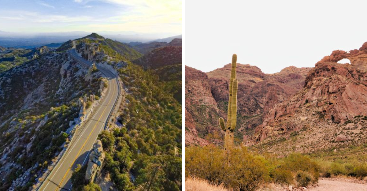
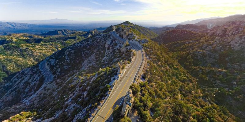
1. Apache Trail Scenic Drive
Picture yourself navigating one of Arizona’s most legendary routes, where every curve reveals something more spectacular than the last.
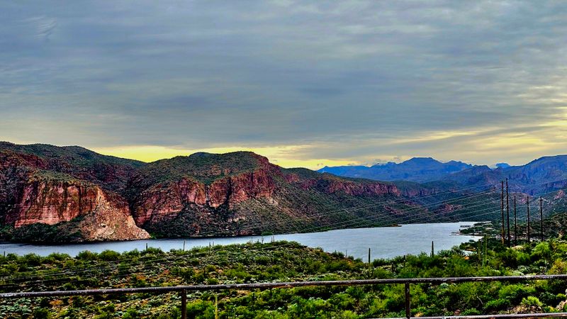
The Apache Trail stretches roughly 40 miles from Apache Junction to Theodore Roosevelt Lake, offering an adventure that feels both wild and wonderfully accessible.
This historic pathway once served as a stagecoach route and later became essential during the construction of Roosevelt Dam in the early 1900s.
Rolling through the Superstition Mountains, you’ll encounter dramatic elevation changes that provide sweeping views of canyon lands and desert valleys below.
The first section from Apache Junction to Tortilla Flat follows a paved road that’s easy for any vehicle to handle.
Tortilla Flat itself is a quirky little spot worth stopping at, where you can grab a famous prickly pear ice cream cone and browse Old West memorabilia.
Beyond Tortilla Flat, the route transforms into a gravel road that winds closer to cliff edges, demanding more attention but rewarding drivers with even more stunning vistas.
Canyon Lake and Apache Lake shimmer like blue jewels against the tan and rust-colored landscape, creating perfect photo opportunities.
Lost Dutchman State Park sits near the beginning of the trail at 6109 N Apache Trail, Apache Junction, AZ 85119, offering camping and hiking for those who want to extend their desert experience.
Spring and fall provide the most comfortable temperatures for this journey, though winter months work beautifully too.
Summer heat can be intense, so early morning departures become essential if you’re traveling between June and August.
Bring plenty of water, snacks, and a full tank of gas since services become sparse once you leave Apache Junction behind.
The entire drive typically takes three to four hours without stops, but you’ll want to budget extra time for the scenery that practically begs you to pull over and soak it all in.
2. Red Rock Scenic Byway
Ever wondered what it feels like to drive through a painting?
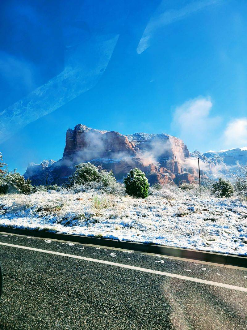
The Red Rock Scenic Byway between Sedona and the Village of Oak Creek delivers exactly that sensation as crimson cliffs tower above the roadway in shapes that spark imagination.
This relatively short 7.5-mile stretch along State Route 179 packs more visual punch per mile than almost any other drive in the Southwest.
Bell Rock stands as perhaps the most photographed landmark along this route, its distinctive shape rising 4,919 feet above sea level and glowing especially bright during golden hour.
Cathedral Rock appears further north, its twin spires creating a silhouette that has graced countless postcards and calendars.
Pullouts dot the highway frequently, giving you safe places to stop and capture images or simply stand in awe of geology’s masterpiece.
What makes this byway particularly special is how it transitions between ecosystems, starting in high desert terrain before climbing into areas where juniper and pinyon pine trees become more common.
The elevation shift isn’t dramatic enough to cause discomfort, but it’s noticeable in the changing vegetation and slightly cooler temperatures as you head north toward Sedona.
Red Rock State Park, located at 4050 Red Rock Loop Road, Sedona, AZ 86336, offers trails and a visitor center where you can learn about the area’s natural and cultural history.
Traffic can get heavy during peak tourist seasons, especially on weekends when visitors flock to Sedona’s galleries, restaurants, and hiking trails.
Weekday mornings tend to be quieter, allowing you to experience the scenery with fewer crowds.
The drive works perfectly as a standalone experience or as part of a longer exploration of the Sedona area.
Unlike some desert routes that require rugged vehicles, this paved highway welcomes any car, making it ideal for families, seniors, or anyone who wants spectacular scenery without challenging road conditions.
3. Catalina Highway
Starting at Tucson’s desert floor and climbing nearly 6,000 feet into cool pine forests, Catalina Highway offers a climate journey that feels like traveling from Mexico to Canada in just 27 miles.
Officially designated as the Sky Island Scenic Byway, this route up the Santa Catalina Mountains showcases an incredible transformation that few roads anywhere can match.
Saguaro cacti dominate the lower elevations, standing tall and proud against the rocky slopes.
As you gain altitude, these desert giants gradually disappear, replaced first by scrubby vegetation, then oak trees, and eventually towering ponderosa pines.
The temperature drops about three to five degrees for every thousand feet of elevation gain, meaning the summit near Mount Lemmon can be 30 degrees cooler than Tucson below.
This makes Catalina Highway a favorite escape for locals during scorching summer months when the valley becomes almost unbearably hot.
Multiple overlooks provide chances to pull off and gaze back toward Tucson, which appears smaller and smaller as you climb higher.
Windy Point Vista, roughly halfway up the mountain, ranks among the most popular stops with its expansive views and interpretive signs explaining the geology and ecology.
The highway continues to Summerhaven, a tiny mountain village with a few restaurants and shops that somehow survived a devastating wildfire in 2003.
Winter brings an entirely different experience when snow blankets the upper reaches, creating Arizona’s southernmost ski area at Mount Lemmon Ski Valley.
The contrast of skiing in the morning and returning to warm desert sunshine in Tucson by afternoon delights visitors who didn’t know such variety existed in Arizona.
Bear Canyon Trailhead near the base offers hiking opportunities at 4900 E Speedway Blvd, Tucson, AZ 85712.
The entire drive takes about an hour without stops, but you’ll want at least half a day to truly appreciate the ecological zones and scenic overlooks along the way.
4. Vermilion Cliffs Highway
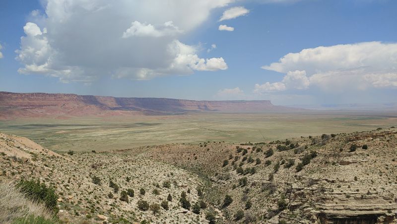
Isolation and grandeur define the Vermilion Cliffs Highway, where you might drive for miles seeing more ravens than vehicles.
This section of U.S. Route 89A stretches between Marble Canyon and Jacob Lake, passing through the Arizona Strip in the state’s remote northwestern corner.
The Vermilion Cliffs themselves rise like a massive wall of layered rock, their bands of red, orange, and cream creating a geological timeline visible from miles away.
Condors occasionally soar overhead, their enormous wingspans unmistakable as they ride thermal currents above the cliffs.
These critically endangered birds were reintroduced to this area as part of a conservation effort, and spotting one ranks among the most thrilling wildlife encounters possible in Arizona.
The Vermilion Cliffs National Monument protects this landscape, though much of it remains undeveloped and wild, exactly as it should be.
Marble Canyon marks the eastern end of this route, where the Colorado River has carved a deep gorge that’s actually the beginning of the Grand Canyon system.
Navajo Bridge spans this chasm, and walking across the pedestrian portion lets you peer down at the river flowing 467 feet below.
The Navajo Bridge Interpretive Center sits at the west end, offering historical displays and often California condor viewing opportunities.
Services are extremely limited along this highway, with Cliff Dwellers Lodge being one of the few outposts where you can grab supplies or a meal.
Cell phone coverage disappears for long stretches, adding to the sense of genuine remoteness that’s increasingly rare in modern America.
This route demands preparation with a reliable vehicle, plenty of fuel, extra water, and snacks since help isn’t just around the corner.
The drive covers roughly 60 miles of high desert plateau, with elevations around 5,000 to 6,000 feet providing somewhat cooler temperatures than lower desert areas.
Spring wildflowers can be spectacular here after wet winters, painting the usually muted landscape with unexpected bursts of yellow, purple, and pink.
5. Ajo Mountain Drive
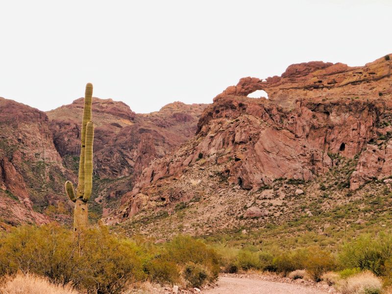
Down near the Mexican border, where the Sonoran Desert shows its most diverse character, Ajo Mountain Drive loops through landscapes that feel almost otherworldly.
This 21-mile dirt road circles through Organ Pipe Cactus National Monument, showcasing plant species found nowhere else in the United States.
The namesake organ pipe cactus grows in clusters that resemble the pipes of a church organ, their multiple arms reaching skyward without the single main trunk that defines saguaros.
Driving this route feels like entering a botanical garden designed by nature itself, with an incredible variety of cacti, shrubs, and desert trees adapted to the harsh conditions.
Elephant trees with their thick, twisted trunks store water in their spongy wood, while senita cacti sport whisker-like spines near their tops that give them a shaggy appearance.
The Estes Canyon area along the route provides particularly good opportunities to see these diverse plants up close without leaving your vehicle.
Mountains rise dramatically on both sides of the drive, their rocky slopes colored in shades of brown, gray, and rust that change with the angle of the sun.
Several pullouts offer chances to stop and absorb the silence, which can be profound in this remote corner of Arizona.
The Kris Eggle Visitor Center at 10 Organ Pipe Drive, Ajo, AZ 85321 serves as the monument headquarters and provides excellent exhibits about the desert ecosystem.
This route requires a high-clearance vehicle, though four-wheel drive isn’t necessary under normal conditions.
After heavy rains, portions of the road can become impassable, so checking conditions at the visitor center before starting makes good sense.
The complete loop takes two to three hours at the recommended slow speeds, which help protect both your vehicle and the fragile desert environment.
Winter months from November through March offer the most comfortable temperatures, while summer heat here can be genuinely dangerous without proper precautions.
Bring significantly more water than you think you’ll need, as the isolation and heat create situations where dehydration can happen quickly.
6. White Tank Mountain Regional Park Loop
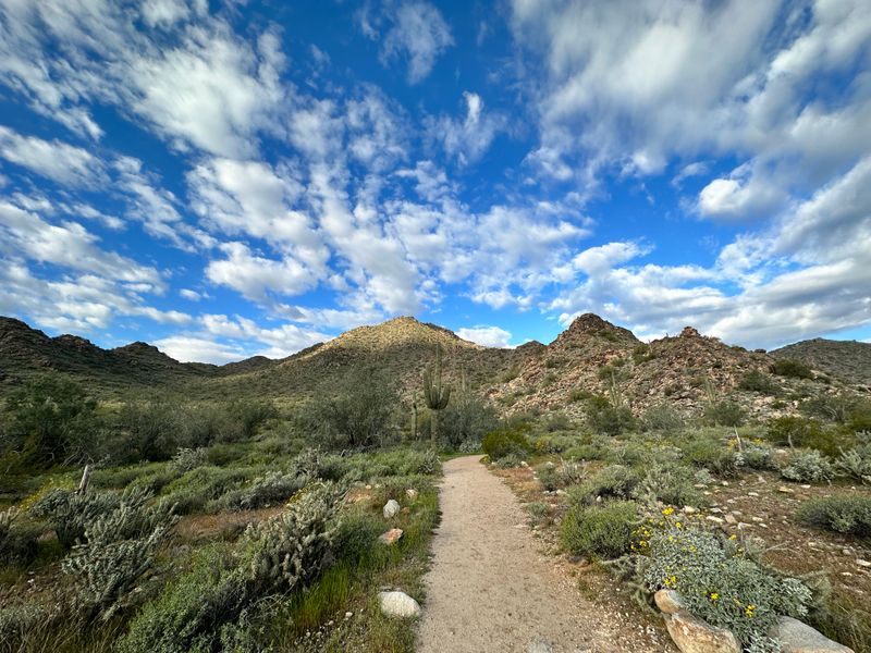
Just west of Phoenix’s sprawling suburbs, White Tank Mountain Regional Park provides an easily accessible desert experience without requiring a full day of travel.
The park’s scenic drive winds through classic Sonoran Desert terrain where saguaros stand guard over a landscape of creosote bushes, palo verde trees, and rocky washes.
White granite formations that give the mountains their name appear throughout the park, their pale color contrasting beautifully with the surrounding darker rock and green vegetation.
Several picnic areas and trailheads line the route, making it simple to combine a scenic drive with short walks or longer hikes if you’re feeling energetic.
The Waterfall Trail leads to a seasonal cascade that flows after winter rains, creating a rare desert waterfall experience.
Petroglyph Plaza showcases ancient rock art created by the Hohokam people who inhabited this region centuries ago, their symbols and figures still visible on the dark rock surfaces.
What makes this drive particularly valuable is its proximity to Phoenix, allowing visitors staying in the metropolitan area to experience genuine desert scenery within a 30-minute drive.
The park gets busy on pleasant winter weekends when Phoenix residents seek outdoor recreation, but weekday visits or early morning arrivals usually guarantee a more peaceful experience.
The main park road is fully paved and suitable for any vehicle, including RVs and vehicles towing trailers.
The park entrance sits at 20304 W White Tank Mountain Road, Waddell, AZ 85355, with a small per-vehicle fee required for entry.
Competition Cave Trail and Black Rock Trail offer additional hiking options for those who want to explore beyond the scenic drive.
Spring wildflower displays can be exceptional here during years with adequate winter rainfall, typically peaking in March.
The drive itself covers about 10 miles roundtrip, taking perhaps 30 minutes without stops but easily filling several hours when you factor in photo opportunities, short walks, and picnic breaks.
Summer temperatures soar well above 100 degrees, making early morning the only sensible time for visits between May and September.
7. Coronado Trail Scenic Byway
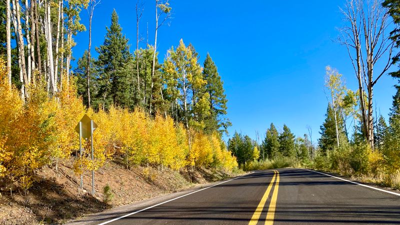
Buckle up for one of America’s most dramatic drives, where 460 curves pack into just 123 miles of mountain highway.
The Coronado Trail Scenic Byway follows U.S. Route 191 from Clifton northward to Springerville, climbing from desert lowlands through multiple life zones into cool mountain forests.
Named for Spanish explorer Francisco Vásquez de Coronado, who may have traveled through this region in 1540, the modern highway wasn’t completed until 1926 and remains an engineering marvel.
Elevation changes of more than 5,000 feet create constantly shifting scenery as desert grasslands give way to oak woodlands, then pine forests, and eventually spruce-fir forests near the highest points.
Hairpin turns and steep grades demand full attention from drivers, but frequent pullouts provide safe places to stop and catch your breath while admiring views that stretch for dozens of miles.
The highway reaches its highest point at nearly 9,200 feet elevation, where temperatures can be 30 degrees cooler than the desert valleys below.
Autumn transforms the aspens into rivers of gold that flow down mountainsides, creating some of Arizona’s finest fall color displays.
Wildlife sightings are common, with elk, deer, and wild turkeys frequently spotted near the roadway, especially during early morning or evening hours.
The Apache-Sitgreaves National Forests encompass much of the route, offering numerous campgrounds and hiking trails for those wanting to explore beyond the pavement.
This journey isn’t one to rush, with most travelers taking four to five hours to complete the full distance, and many choosing to make it an overnight trip with stops in Alpine or Hannagan Meadow.
The Hannagan Meadow Lodge provides rustic accommodations and meals at milepost 232 along the route.
Winter can bring snow and ice to higher elevations, sometimes closing the road temporarily, so checking conditions before departure is essential during cold months.
Services are limited along the route, making it crucial to start with a full fuel tank and adequate supplies for the journey ahead.
Dear Reader: This page may contain affiliate links which may earn a commission if you click through and make a purchase. Our independent journalism is not influenced by any advertiser or commercial initiative unless it is clearly marked as sponsored content. As travel products change, please be sure to reconfirm all details and stay up to date with current events to ensure a safe and successful trip.