Oregon stretches from the wild Pacific coastline to deep river gorges, from snowcapped volcanic peaks to endless high desert horizons.
Between these extremes lies a network of scenic drives that locals know by heart, roads they return to again and again with cameras ready.
Every curve reveals another postcard moment, whether it’s a waterfall tumbling beside a historic highway or a mountain reflected perfectly in an alpine lake.
These routes aren’t just about getting from point A to point B.
They’re destinations in themselves, offering views so striking that even longtime residents pull over to capture the scene.
Oregon’s landscape shifts dramatically within just a few hours of driving, making it one of the most photographically diverse states in the country.
The drives featured here represent the very best of what Oregon offers, from coastal cliffs battered by ocean waves to volcanic craters filled with impossibly blue water.
1. Pacific Coast Scenic Byway (Highway 101)
Highway 101 runs the entire length of Oregon’s coastline, offering over three hundred miles of uninterrupted ocean views.
From the moment you start driving, the Pacific stretches endlessly to the west, while rugged headlands and sandy beaches appear around every bend.
Cannon Beach marks one of the most iconic stops along this route, where Haystack Rock rises dramatically from the sand, creating a silhouette that photographers never tire of capturing.
Further south, the highway winds past charming coastal towns and state parks that protect some of the most pristine shoreline in America.
Sea stacks dot the water near Bandon, their weathered shapes standing against crashing waves.
Lighthouses perch on rocky promontories, guiding ships and providing perfect foreground interest for sunset shots.
Between these famous landmarks, countless pullouts invite spontaneous stops.
Driftwood-strewn beaches, tide pools teeming with life, and forested headlands all compete for attention.
The route passes through Yachats, Florence, and Newport, each offering its own coastal character and photographic opportunities.
Weather along the coast changes quickly, adding drama to any drive.
Morning fog can blanket the shore, then lift suddenly to reveal brilliant sunshine.
Storm watching in winter brings massive waves that crash spectacularly against the rocks.
Summer brings clearer skies and calmer seas, ideal for capturing the coast’s gentler moods.
This byway never gets old for Oregon residents.
They return throughout the seasons, knowing the light and conditions create entirely different scenes each time.
The combination of accessibility and raw natural beauty makes it impossible to drive without stopping multiple times to photograph the ever-changing coastal landscape.
Address: Highway 101, Oregon Coast
2. Historic Columbia River Highway
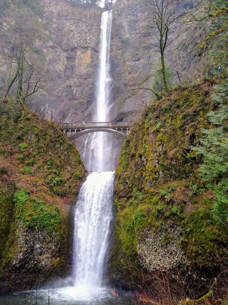
Built in the early twentieth century, this engineering marvel was designed specifically to showcase the Columbia River Gorge’s stunning scenery.
The highway curves gracefully along cliffsides, offering glimpses of the mighty river below while leading travelers past a concentrated collection of waterfalls.
Multnomah Falls, the crown jewel of the gorge, drops in two tiers with a picturesque bridge spanning between them, creating one of the most photographed scenes in the entire state.
Crown Point Vista House sits atop a promontory, providing panoramic views up and down the gorge.
The octagonal stone building itself adds architectural interest to landscape shots.
From this vantage point, the river winds through steep basalt cliffs, with Washington’s mountains visible across the water.
Latourell Falls, Wahkeena Falls, and Horsetail Falls all lie within a short drive, each offering distinct characteristics.
Some plunge straight down smooth rock faces, while others cascade over multiple levels.
The lush greenery surrounding these waterfalls stays vibrant year-round thanks to the gorge’s unique climate.
Rowena Crest provides a completely different perspective, where the highway loops dramatically through rolling hills covered in wildflowers during spring.
The curves of the road itself become part of the composition, with layers of hills receding into the distance.
This eastern section of the highway transitions from dense forest to open grassland, showcasing the dramatic ecological shift that occurs within the gorge.
Local photographers time their visits carefully here.
Spring brings wildflower blooms and swollen waterfalls.
Autumn adds golden foliage.
Winter occasionally coats everything in ice, transforming familiar scenes into crystalline wonderlands.
Each season offers completely different photographic possibilities along this historic route.
Address: Historic Columbia River Highway, Corbett, OR 97019
3. Cascade Lakes Scenic Byway
Winding through the volcanic landscape west of Bend, this alpine drive connects a chain of pristine mountain lakes.
Each body of water reflects the surrounding peaks differently, creating endless opportunities for mirror-image photography.
The route climbs through ponderosa pine forests before emerging into higher elevation terrain where the trees thin and volcanic rock becomes more prominent.
Trillium Lake delivers one of Oregon’s most famous views, where Mount Hood’s snowy summit reflects perfectly in calm morning waters.
Photographers arrive before dawn to catch the alpenglow, when the mountain turns pink and orange in the early light.
The lake’s accessibility makes it popular, but the view never disappoints.
Beyond Trillium, the byway passes Sparks Lake, Todd Lake, and Devils Lake, each offering unique characteristics.
Some lakes sit in open meadows, while others nestle against forested hillsides.
Bachelor Butte and Broken Top provide dramatic backdrops, their jagged peaks contrasting with the smooth water surfaces.
The volcanic nature of the Cascades shows clearly along this route.
Lava fields stretch across sections of the landscape, their dark rock creating stark contrast with green forest and blue sky.
Cinder cones dot the horizon, reminders of the explosive forces that shaped this region.
Summer brings the best driving conditions, when the entire byway is clear of snow.
Wildflowers bloom in alpine meadows, adding splashes of color to compositions.
Fall transforms the lakeshores with golden aspen and rust-colored shrubs.
Even during the short summer season, locals make multiple trips, knowing that conditions change weekly and each visit offers something new to photograph.
Address: Cascade Lakes Scenic Byway, Deschutes National Forest, Bend, OR 97701
4. Crater Lake National Park (Rim Drive)
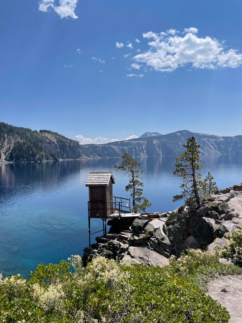
Circling the deepest lake in the United States, Rim Drive offers constantly changing perspectives on one of nature’s most spectacular creations.
The volcanic caldera holds water so blue it seems almost unnatural, a color created by the lake’s extraordinary depth and purity.
Wizard Island rises from the water like a miniature volcano, adding a focal point to the vast expanse of blue.
The drive reaches elevations where snow lingers well into summer.
In fact, Rim Drive typically doesn’t fully open until July, and even then, patches of snow remain in shaded areas.
This extended winter creates a short but intense season when visitors can actually drive the complete loop.
The contrast between brilliant blue water and white snowbanks creates striking photographic opportunities.
Multiple viewpoints punctuate the thirty-three-mile circuit, each revealing different angles on the caldera.
Some look straight down steep cliffs to the water far below.
Others provide broader perspectives that include the surrounding volcanic landscape.
The Watchman and Cloudcap overlooks rank among the most popular spots for capturing the lake’s full majesty.
Light changes dramatically throughout the day here.
Morning sun illuminates the eastern rim while the western side remains in shadow.
By afternoon, the angles reverse.
Sunset brings golden light that warms the volcanic rock while the water maintains its deep blue hue.
Locals know that midday, when the sun is directly overhead, often produces the most intensely blue water.
Weather at this elevation can change rapidly.
Clear morning skies may give way to afternoon thunderstorms.
These dramatic weather shifts add variety to photographs, with clouds casting shadows across the water or fog partially obscuring the lake’s surface, creating an air of mystery around this natural wonder.
Address: Rim Drive, Crater Lake National Park, OR 97604
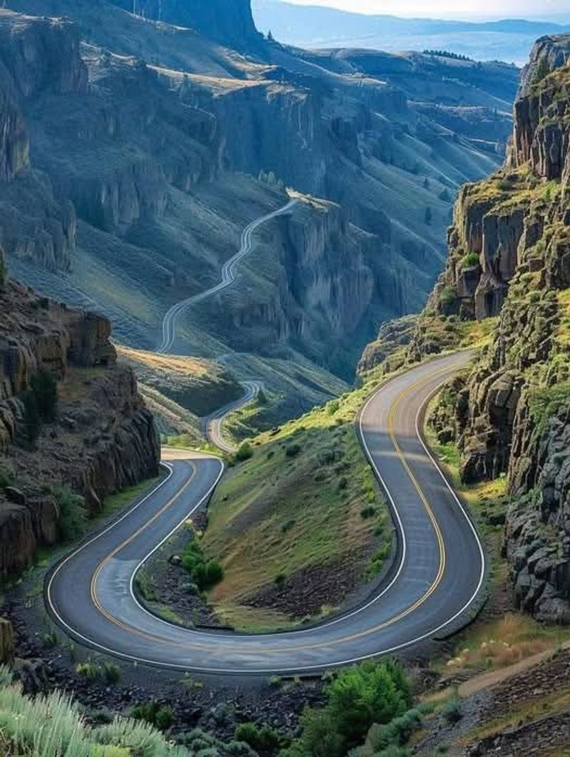
5. Hells Canyon Scenic Byway
Oregon’s remote eastern edge holds a surprise that many visitors never expect: North America’s deepest river gorge.
The Hells Canyon Scenic Byway follows the Snake River as it carves through layers of ancient rock, creating vertical relief that exceeds even the Grand Canyon.
The drive requires commitment, as services are sparse and the route demands attention, but the rewards match the effort.
The byway climbs to overlooks that peer down into the gorge, where the Snake River appears as a thin ribbon thousands of feet below.
The scale is difficult to comprehend until you spot a boat on the water and realize how tiny it appears.
Layers of basalt create striped patterns on the canyon walls, telling a geological story millions of years in the making.
Unlike Oregon’s western forests, this landscape embraces an arid character.
Grasses and sagebrush cover the hillsides, with occasional stands of pine at higher elevations.
The colors shift from green in spring to golden brown by summer’s end.
Wildflowers bloom briefly after winter rains, painting the slopes with unexpected color.
The route passes through tiny communities that feel far removed from modern life.
Homesteads cling to hillsides, and old ranching operations continue traditions established generations ago.
This human history adds context to the natural grandeur, showing how people have adapted to this challenging but beautiful environment.
Photography here requires different techniques than in Oregon’s lusher regions.
The vast scale and open skies create challenges with exposure and composition.
Early morning and late afternoon light add dimension to the canyon walls, revealing textures that disappear in harsh midday sun.
Local photographers return repeatedly, learning to read the light and capture the unique character of this remote corner of Oregon.
Address: Hells Canyon Scenic Byway, Forest Road 39, Halfway, OR 97834
6. Rogue-Umpqua Scenic Byway
Two of Oregon’s most celebrated rivers share this byway, which winds through dense forests in the southern part of the state.
The route follows first one river, then the other, connecting them through mountain passes where Douglas firs tower overhead and moss covers everything in sight.
The perpetual moisture creates a lushness that photographers find endlessly appealing, with every shade of green imaginable represented in the vegetation.
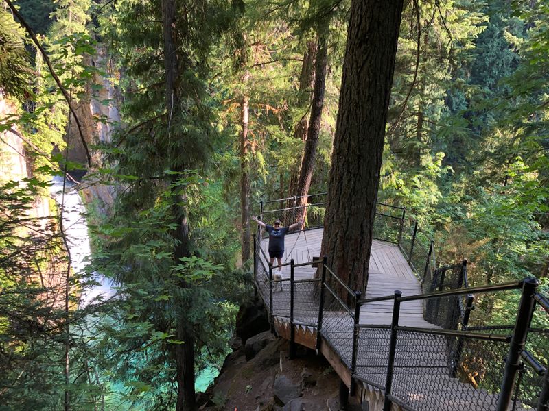
Toketee Falls stands out among the many waterfalls along this route.
The water drops in two distinct tiers, framed by columnar basalt that creates a natural amphitheater.
The viewing platform provides an ideal vantage point, though the short hike required to reach it adds just enough effort to thin the crowds slightly.
The Rogue River section passes through areas where the water tumbles over boulders and through narrow channels.
These rapids attract whitewater enthusiasts, but they also create dynamic scenes for photographers.
The interplay of moving water, dark rocks, and surrounding forest offers countless compositional possibilities.
Pullouts along the highway provide easy access to riverside viewpoints.
Further along, the Umpqua River presents a calmer character in some sections, with deeper pools that reflect the forest canopy.
Old growth trees line portions of the route, their massive trunks dwarfing the cars that pass beneath.
These ancient forests survived logging that claimed much of Oregon’s original woodland, making them particularly precious.
The byway passes through small towns that serve as gateways to the surrounding wilderness.
These communities maintain a connection to the timber industry that once dominated the region, though tourism now plays an increasingly important role.
Local residents take pride in their rivers and forests, and they’re often happy to share their favorite photo spots with visitors who show genuine interest in the area.
Address: Rogue-Umpqua Scenic Byway, Highway 138, Roseburg, OR 97470
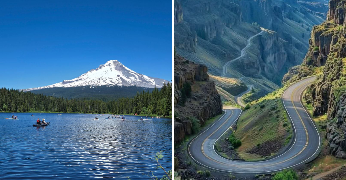
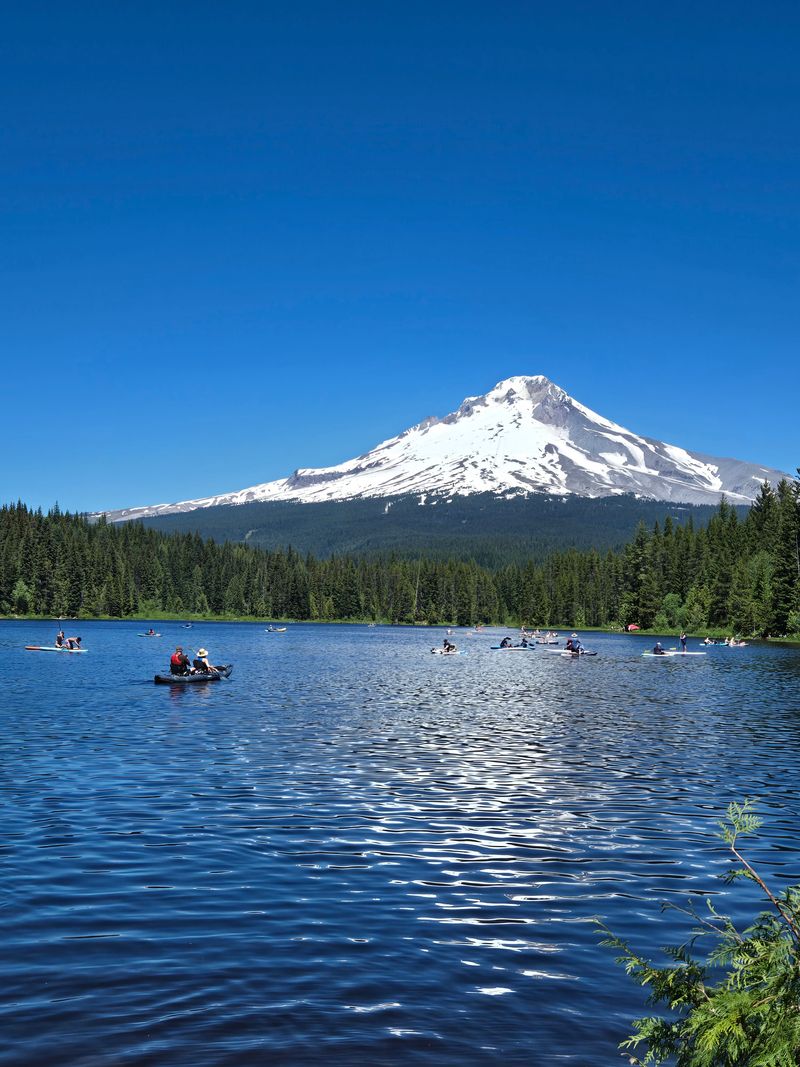
7. Mount Hood Scenic Byway
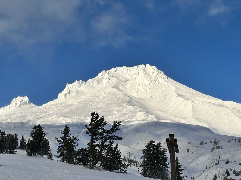
Oregon’s highest peak dominates the landscape along this loop drive that circles the mountain through varied terrain.
Starting in the Hood River Valley, the route passes through orchards where fruit trees bloom spectacularly in spring.
Mount Hood rises above the valley floor, its glaciated summit visible from almost every vantage point along the drive.
The byway climbs through dense forest as it approaches Timberline Lodge, the historic structure perched high on the mountain’s southern flank.
The lodge itself provides a stunning foreground for mountain photography, its rustic architecture complementing the wild landscape.
From the parking area, hikers can access alpine meadows that burst with wildflowers during the brief summer season.
Continuing around the mountain, the route passes through Government Camp and descends toward Trillium Lake, where the mountain’s reflection creates one of the Pacific Northwest’s most iconic images.
The perspective from the lake’s shore shows Mount Hood’s classic pyramidal shape, with forest framing the view on both sides.
The eastern side of the loop offers completely different scenery.
The landscape transitions from wet forest to drier pine woodland as the rain shadow effect takes hold.
Views open up, providing longer sightlines and different angles on the mountain.
Small communities along this stretch maintain a quieter character than the busier western side.
Locals drive this loop in all seasons.
Winter brings skiing and snowboarding to the mountain’s slopes, with fresh snow creating pristine white landscapes.
Spring means waterfalls running full and wildflowers beginning their display.
Summer offers the clearest weather and best access to high elevation areas.
Autumn paints the forests in warm tones that contrast beautifully with the mountain’s permanent snow.
Each season transforms the drive completely, ensuring that regular visitors always find something new to photograph.
Address: Mount Hood Scenic Byway, Highway 35, Mount Hood, OR 97041
8. McKenzie Pass-Santiam Pass Scenic Byway
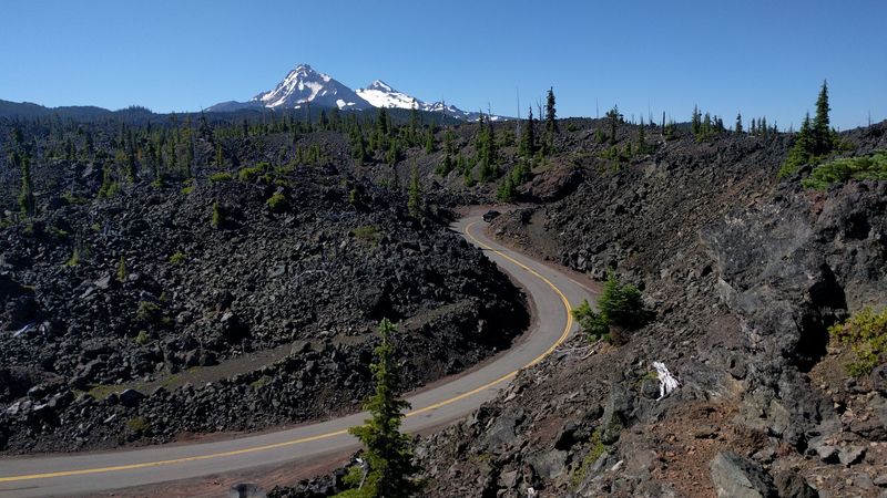
Volcanic drama defines this high-elevation route that crosses the Cascade Range through two mountain passes.
The byway traverses lava fields so recent in geological terms that vegetation has barely begun to reclaim the blackened landscape.
These flows create an otherworldly scene, especially where the dark rock contrasts with snow-covered peaks in the background.
The Dee Wright Observatory sits atop McKenzie Pass, built from the same lava rock that surrounds it.
This stone structure provides panoramic views of the Cascades, with multiple volcanic peaks visible on clear days.
Interpretive windows identify each mountain, helping visitors understand the volcanic arc that created this landscape.
The short trails around the observatory wind through the lava field, offering close-up views of the tortured rock formations.
Descending the eastern side, the byway passes through old growth forest before emerging into more open terrain.
Clear Lake lives up to its name, with water so transparent that a drowned forest remains visible beneath the surface.
These ghostly trees, preserved by the cold water, create an eerie underwater landscape that photographers capture from the shore.
The route climbs again to Santiam Pass, where the landscape opens up to reveal mountain meadows and distant peaks.
Wildflower displays here rival any in Oregon, with lupine, paintbrush, and countless other species creating waves of color that ripple across the slopes.
The combination of flowers, mountains, and big sky provides endless compositional opportunities.
Snow closes this byway for much of the year, typically from October through June.
The short open season makes it feel special to locals, who plan trips carefully to catch the peak wildflower bloom or the clearest weather.
The drive requires no special vehicle or skills, but the high elevation and exposed terrain demand respect for changing weather conditions.
Address: McKenzie Pass-Santiam Pass Scenic Byway, Highway 242, Sisters, OR 97759
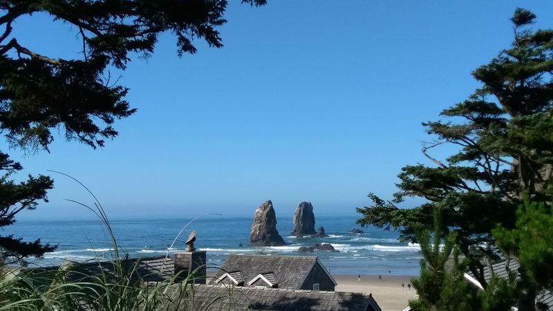
9. Samuel H. Boardman State Scenic Corridor
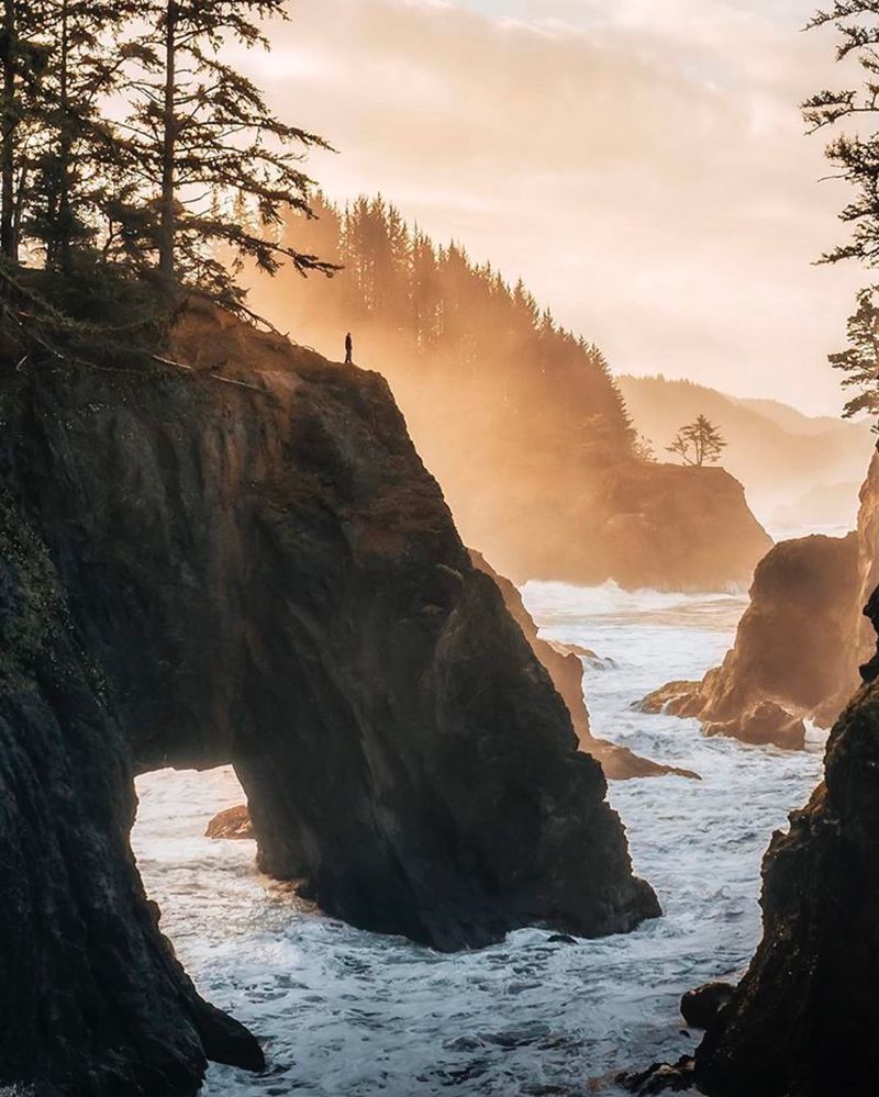
Tucked into Oregon’s southern coast, this relatively short stretch of Highway 101 packs more dramatic scenery per mile than almost anywhere else in the state.
The corridor protects twelve miles of coastline where forested headlands plunge into the Pacific, creating a landscape of hidden coves, natural arches, and towering sea stacks.
Most travelers speed past on their way to California or north toward Portland, but locals know to slow down and explore.
Natural Bridges stands out as one of the corridor’s most photographed features.
Wave action carved completely through a rocky promontory, creating an arch that frames views of the ocean beyond.
The viewing area sits right beside the highway, making it easily accessible, though a short trail leads down for closer perspectives.
The arch’s size and shape change depending on the viewing angle, rewarding exploration.
Further along, numerous pullouts provide access to viewpoints that reveal different aspects of this rugged coast.
Some look down on pocket beaches accessible only at low tide.
Others peer across water to offshore rocks where seabirds nest by the thousands.
The forest comes right to the cliff edges in places, with windswept Sitka spruce leaning away from the prevailing winds.
Arch Rock, Thunder Rock Cove, and Whaleshead Beach all lie within this corridor, each offering distinct photographic opportunities.
The concentration of features means visitors can spend an entire day exploring just these few miles, stopping repeatedly to capture different scenes.
Morning fog often blankets the coast, then burns off by midday, creating dramatic lighting transitions.
Local photographers return to this corridor throughout the year.
Winter storms bring massive waves that explode against the rocks with tremendous force.
Summer offers calmer conditions and clearer skies.
Spring and fall provide a balance, with interesting weather but manageable conditions.
The corridor never looks the same twice, making it a perpetual favorite for those seeking fresh coastal imagery.
Address: Samuel H.
Boardman State Scenic Corridor, Highway 101, Brookings, OR 97415
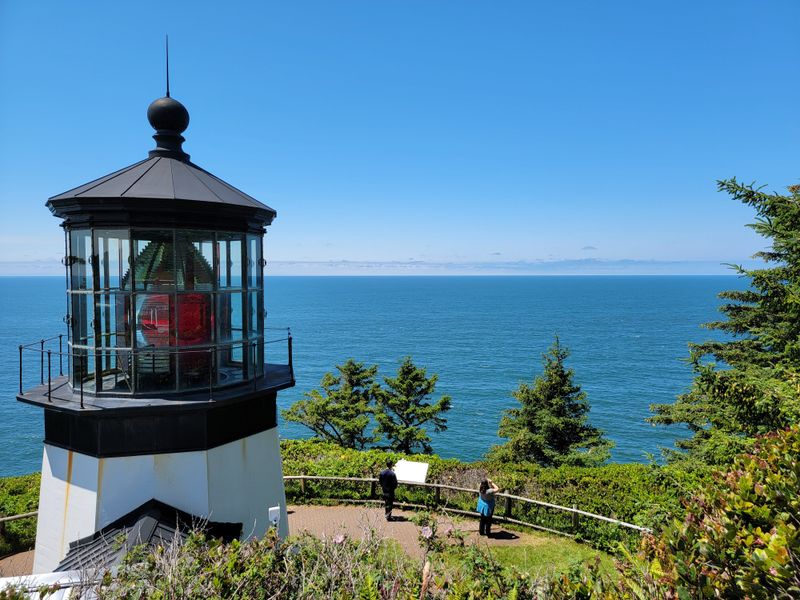
10. Three Capes Scenic Loop
Breaking away from Highway 101, this loop road connects three distinctive headlands that jut into the Pacific.
Each cape offers its own character and photographic possibilities, while the connecting route passes through coastal forest and small communities that maintain an authentic Oregon coast atmosphere.
The entire loop can be driven in a few hours, but rushing through would miss the point entirely.
Cape Meares starts the journey with its lighthouse perched on a dramatic cliff.
The octagonal tower, though short compared to many lighthouses, sits high enough above the water to guide ships effectively.
The Octopus Tree nearby adds a quirky element, a Sitka spruce with multiple trunks that spread like tentacles.
Seabird colonies nest on offshore rocks, and the sounds of their calls carry on the wind.
Cape Lookout extends far into the ocean, creating a narrow peninsula that provides views both north and south along the coast.
The trail to the cape’s tip passes through old growth forest before emerging onto the exposed headland.
From the end, gray whales are often visible during their migration seasons, adding movement and life to seascape compositions.
Cape Kiwanda concludes the loop with its massive sandstone formation and sandy beach.
Unlike the other capes with their dark basalt, Kiwanda’s golden rock glows warmly in afternoon light.
The cape provides shelter for dories that launch directly through the surf, a tradition that continues from earlier fishing days.
Photographers gather here for sunset, when the light turns the sandstone orange and silhouettes the offshore Haystack Rock.
Between the capes, the route passes through Oceanside and Pacific City, small towns that provide services without overwhelming the natural setting.
Locals appreciate this loop for its variety and accessibility, making it a favorite for quick photo excursions when time is limited but the urge to capture Oregon’s coastal beauty is strong.
Address: Three Capes Scenic Loop, Netarts, OR 97143
Dear Reader: This page may contain affiliate links which may earn a commission if you click through and make a purchase. Our independent journalism is not influenced by any advertiser or commercial initiative unless it is clearly marked as sponsored content. As travel products change, please be sure to reconfirm all details and stay up to date with current events to ensure a safe and successful trip.