Oregon is home to some of the most breathtaking landscapes in the entire Pacific Northwest region.
From towering coastal cliffs to dense forests filled with ancient trees, this state offers endless opportunities for outdoor exploration.
Whether you’re searching for a peaceful morning hike or a stunning sunset viewpoint, Oregon delivers natural beauty at every turn.
Scenic overlooks and nature walks provide the perfect way to connect with the environment while enjoying fresh air and incredible views.
Many of these spots are accessible year-round, making them ideal for families, solo adventurers, and photography enthusiasts alike.
Exploring these trails and viewpoints allows you to witness wildlife, unique geological formations, and ecosystems found nowhere else.
Each destination tells its own story through the landscape, inviting visitors to slow down and appreciate the wonders of the natural world.
Grabbing your hiking boots and heading out to discover these remarkable places will create memories that last a lifetime.
Oregon’s diverse terrain means there’s always something new to see, no matter how many times you visit.Get ready to experience the magic of Oregon’s most scenic overlooks and nature walks.
Cape Perpetua Scenic Area
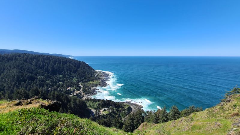
Standing 800 feet above the Pacific Ocean, Cape Perpetua offers one of the most spectacular coastal vistas anywhere along the Oregon shoreline.
The viewpoint sits within the Siuslaw National Forest, where ancient Sitka spruce trees meet dramatic ocean cliffs.
Visitors can drive up to the Cape Perpetua Overlook or hike the Whispering Spruce Trail for a more immersive experience through old-growth forest.
This area features multiple trails ranging from easy to moderate difficulty, including the popular Giant Spruce Trail that leads to a 500-year-old tree.
Tidal pools along the rocky shore reveal colorful sea stars, anemones, and small crabs during low tide.
The Thor’s Well phenomenon, located nearby, creates a dramatic scene as waves crash into a seemingly bottomless sinkhole.
Spring and fall migrations bring gray whales close to shore, making this an excellent whale-watching destination.
The Cape Perpetua Visitor Center, located at 2400 Highway 101 South, Yachats, Oregon 97498, provides educational exhibits about the local ecosystem and Native American history.
Interactive displays help visitors understand the geological forces that shaped this rugged coastline over millions of years.
Photographers flock here during golden hour when the setting sun paints the ocean in shades of orange and pink.
The combination of forest, ocean, and rocky shoreline creates diverse scenery within a compact area.
Families appreciate the variety of trail options, allowing everyone to choose adventures matching their fitness levels and interests.
Winter storms create the most dramatic wave action, though visitors should exercise caution near the water’s edge.
Packed lunches taste better when enjoyed at one of the many scenic picnic areas overlooking the endless Pacific.
Cape Perpetua remains a must-visit destination for anyone exploring Oregon’s central coast.
Smith Rock State Park
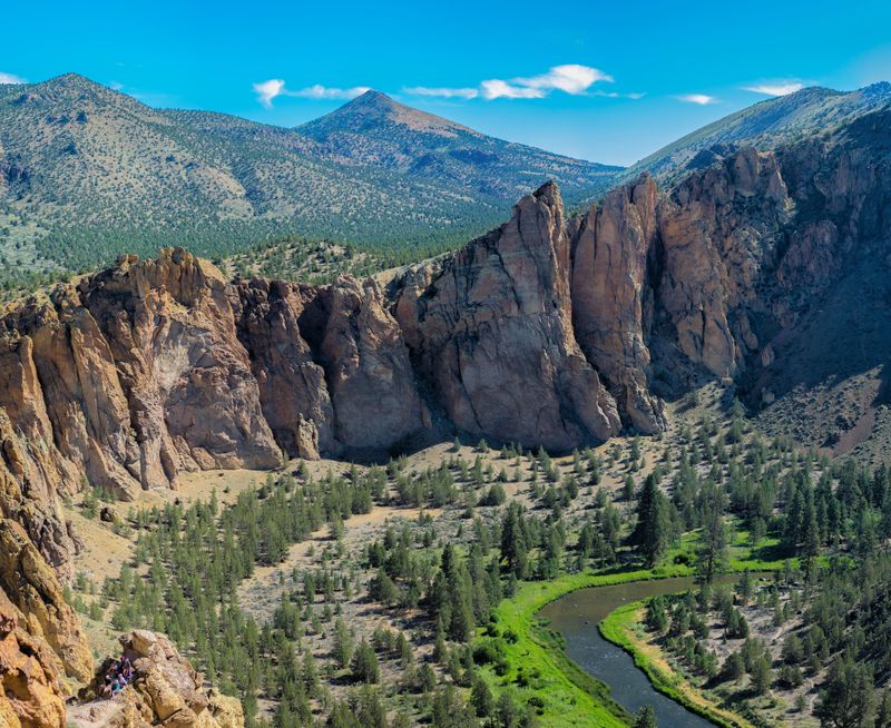
Massive rock formations rise dramatically from the high desert floor, creating one of Oregon’s most photographed landscapes.
Smith Rock State Park showcases towering cliffs composed of volcanic tuff and basalt that glow brilliant shades of orange and red during sunrise and sunset.
Rock climbers from around the world come here to tackle challenging routes, while hikers enjoy trails offering stunning canyon views.
The Misery Ridge Trail provides a challenging but rewarding climb with panoramic vistas across the entire park.
For those seeking easier options, the River Trail follows the Crooked River through the canyon bottom, offering close-up views of the towering cliffs.
Wildflowers bloom across the desert landscape in spring, adding splashes of purple, yellow, and pink to the rusty-colored rocks.
Did you know that Smith Rock is considered the birthplace of American sport climbing?
Pioneering climbers established routes here in the 1980s that changed the sport forever.
Today, you can watch skilled athletes scaling vertical walls while you enjoy a picnic near the river.
The park entrance is located at 9241 NE Crooked River Drive, Terrebonne, Oregon 97760, with ample parking and restroom facilities.
Summer temperatures can exceed 100 degrees, so early morning or evening visits work best during hot months.
Fall offers comfortable hiking weather with fewer crowds and spectacular light for photography.
Wildlife sightings include golden eagles, prairie falcons, mule deer, and river otters along the waterway.
The contrast between the blue sky, red rocks, and green river creates a color palette unlike anywhere else in Oregon.
Whether you’re an experienced hiker or casual nature lover, Smith Rock delivers unforgettable scenery.
Bring plenty of water, wear sturdy shoes, and prepare for an adventure in Oregon’s high desert wonderland.
Rowena Crest Viewpoint
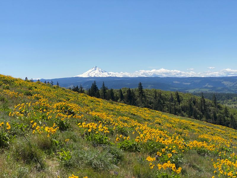
Perched high above the Columbia River Gorge, Rowena Crest delivers sweeping views that stretch for miles in every direction.
The Historic Columbia River Highway winds through this area in graceful curves, creating one of the most scenic drives in America.
Springtime transforms the hillsides into carpets of yellow balsamroot and purple lupine, attracting photographers and nature enthusiasts from across the region.
A short walk from the parking area leads to the main viewpoint, where the Columbia River appears as a silver ribbon far below.
On clear days, Mount Hood dominates the western horizon while Mount Adams rises to the north.
The Tom McCall Nature Preserve, located nearby, protects rare wildflower meadows and offers additional hiking opportunities.
Historic stone walls line portions of the old highway, remnants of the impressive engineering feat completed in the early 1900s.
The viewpoint is located along Historic Highway 30 near Rowena, Oregon, approximately 10 miles east of Hood River.
Interpretive signs explain the geological history of the Columbia River Gorge, carved by massive Ice Age floods.
Sunrise visits reward early risers with magical light as the sun illuminates the gorge from the east.
The area remains accessible year-round, though winter weather can occasionally close the highway.
Birdwatchers spot raptors soaring on thermal currents rising from the sun-warmed hillsides below.
The gentle terrain makes this destination suitable for visitors of all ages and mobility levels.
Many people combine a stop at Rowena Crest with visits to nearby waterfalls and hiking trails throughout the Columbia River Gorge.
Pack a camera with a wide-angle lens to capture the expansive vistas spreading in all directions.
This viewpoint showcases the dramatic beauty that makes the Columbia River Gorge a designated National Scenic Area.
Rowena Crest proves that sometimes the best adventures require minimal effort for maximum reward.
Crater Lake Rim Drive
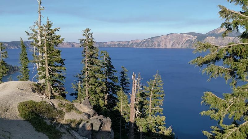
America’s deepest lake fills an ancient volcanic caldera with water so blue it seems almost unreal.
Crater Lake formed nearly 8,000 years ago when Mount Mazama collapsed following a massive eruption.
Today, the 33-mile Rim Drive circles the entire lake, providing access to numerous viewpoints showcasing this natural wonder from different angles.
Each overlook offers unique perspectives on the lake’s intense sapphire color, created by the water’s exceptional purity and depth.
Wizard Island, a volcanic cinder cone, rises from the lake’s western side, accessible by boat during summer months.
The Watchman Trail climbs to a historic fire lookout with 360-degree views of the lake and surrounding Cascade peaks.
Snow typically closes Rim Drive from October through June, making summer the prime visiting season.
The Rim Village Visitor Center, located at Crater Lake National Park, provides exhibits, a café, and the iconic Crater Lake Lodge.
Sunrise at Crater Lake paints the sky in brilliant colors reflected perfectly in the still water below.
Photographers should arrive early to avoid crowds and capture the best light conditions.
The Cleetwood Cove Trail is the only route down to the lake’s shore, descending steeply for about a mile.
Swimming in Crater Lake is permitted, though the water temperature rarely exceeds 55 degrees even in summer.
Wildlife including black bears, elk, and golden-mantled ground squirrels inhabit the surrounding forests.
The park’s elevation ranges from 6,000 to 8,000 feet, so visitors should prepare for cooler temperatures and thinner air.
Evening visits often reveal star-filled skies unpolluted by city lights, making Crater Lake an excellent stargazing destination.
Allow at least half a day to drive the entire Rim Drive and stop at multiple viewpoints.
Crater Lake represents one of Oregon’s most iconic natural treasures, deserving a spot on every nature lover’s bucket list.
Silver Falls State Park
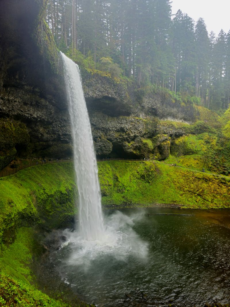
Imagine walking behind a curtain of falling water while surrounded by lush green forest—that’s the magic of Silver Falls State Park.
The Trail of Ten Falls loops 7.2 miles through a canyon containing ten spectacular waterfalls, four of which you can walk behind.
This moderate hike ranks among Oregon’s most popular trails, offering constantly changing scenery as you progress through different sections of the forest.
South Falls, the park’s tallest at 177 feet, greets visitors near the trailhead and provides an impressive introduction to what lies ahead.
The path descends into a cool canyon where Douglas firs, western hemlocks, and bigleaf maples create a dense canopy overhead.
Ferns, moss, and wildflowers cover the forest floor, thriving in the moist environment created by the waterfalls’ constant spray.
Spring runoff creates the most powerful water flow, while autumn transforms the deciduous trees into brilliant shades of yellow and orange.
The park headquarters is located at 20024 Silver Falls Highway SE, Sublimity, Oregon 97385, offering maps, restrooms, and camping information.
Winter hiking is possible when trails aren’t icy, providing a quieter experience with frozen waterfalls creating dramatic ice formations.
Families with young children often hike just to South Falls and back, creating a shorter adventure of about 1.5 miles.
The entire loop takes most hikers between three and four hours, depending on pace and photo stops.
Several smaller waterfalls along the trail offer intimate settings perfect for quiet reflection or picnic breaks.
Photographers should bring polarizing filters to reduce glare from wet rocks and enhance the water’s appearance.
The trail’s well-maintained surface makes it accessible for most fitness levels, though some sections include stairs and steep grades.
Silver Falls State Park showcases Oregon’s signature combination of waterfalls, forests, and natural beauty in one convenient location.
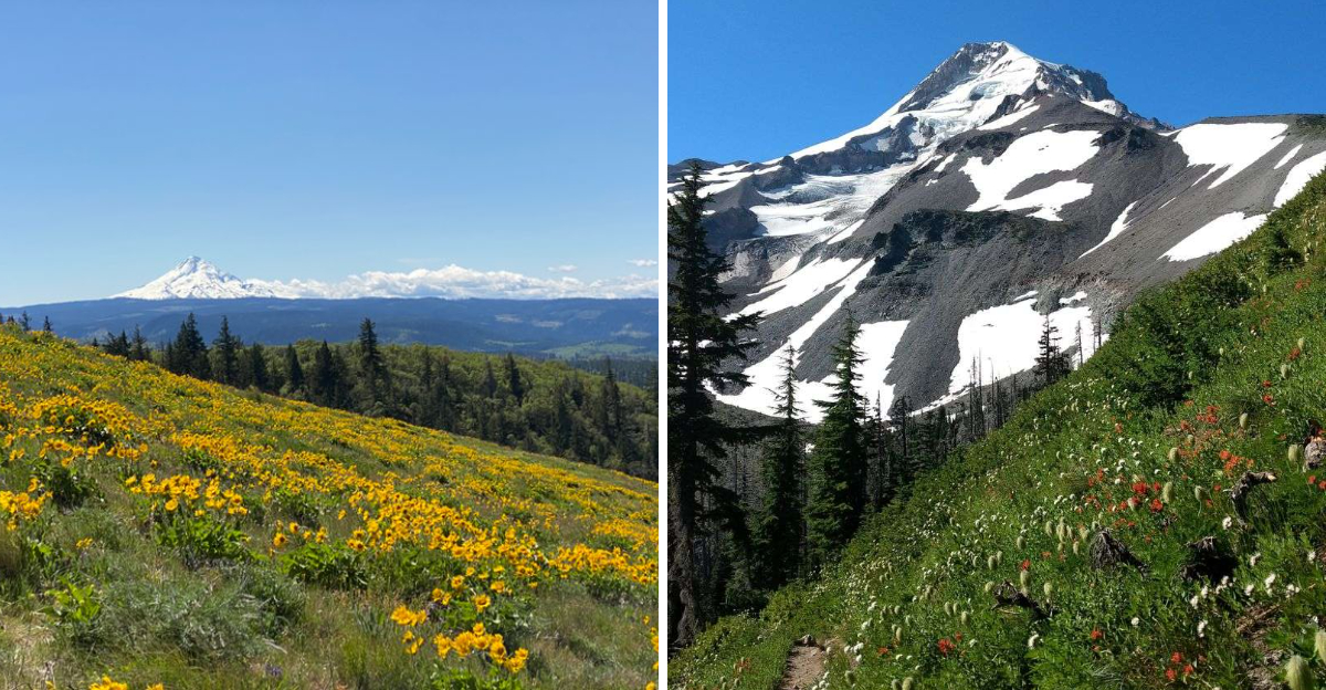
Mount Hood Timberline Trail
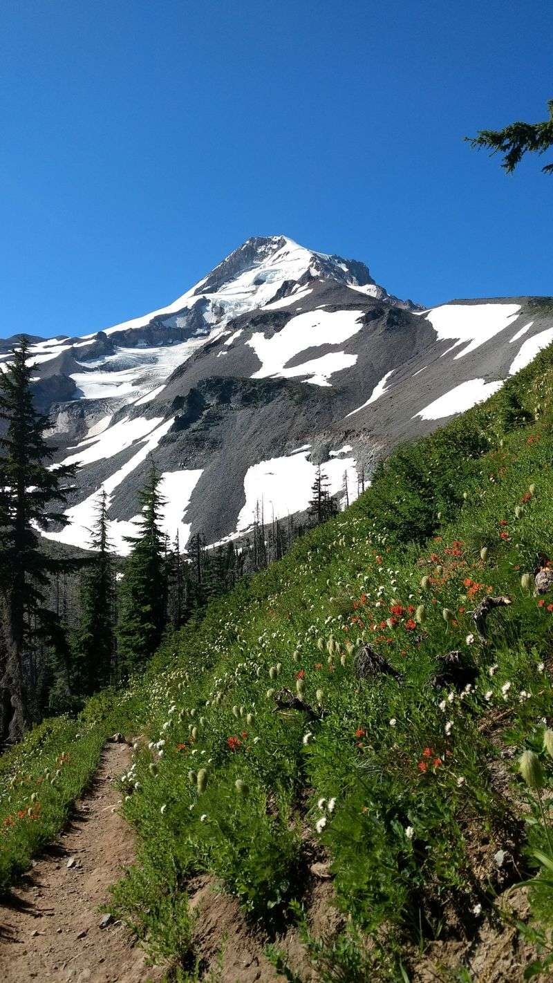
Oregon’s tallest peak dominates the skyline, offering numerous trails through alpine meadows, ancient forests, and volcanic landscapes.
The Timberline Trail circumnavigates Mount Hood for 40 miles, but shorter sections provide incredible day-hiking opportunities.
Wildflower displays peak in late July and early August when avalanche lilies, lupine, and Indian paintbrush blanket the high meadows.
The Paradise Park Trail, accessed from Timberline Lodge, showcases some of the mountain’s most beautiful alpine terrain.
Glaciers cling to Mount Hood’s upper slopes, visible from many viewpoints along the trail.
Rivulets of glacial meltwater create countless small streams threading through the meadows, their cold water perfect for refreshing tired feet.
Timberline Lodge, located at 27500 E Timberline Road, Government Camp, Oregon 97028, serves as a popular starting point for hikes.
This historic lodge, built during the Great Depression, offers dining, lodging, and year-round skiing on Palmer Glacier.
The building itself is worth exploring, featuring hand-crafted woodwork and wrought iron created by skilled artisans.
Mountain weather changes rapidly, so hikers should carry layers, rain gear, and extra food regardless of the forecast.
Clark’s nutcrackers and gray jays often approach hikers hoping for snack handouts, though feeding wildlife is prohibited.
The volcanic soil supports unique plant communities adapted to harsh conditions, including stunted trees shaped by fierce winter winds.
September brings fewer crowds and stable weather, making it an ideal time for hiking Mount Hood’s trails.
Views extend across the Cascade Range to distant peaks including Mount Jefferson, Three Sisters, and Mount Adams.
Sunrise hikes reveal alpenglow painting the glaciers pink before the sun fully rises.
Whether tackling a short nature walk or a challenging day hike, Mount Hood’s trails deliver unforgettable mountain scenery and alpine adventure.
Columbia River Gorge Waterfalls
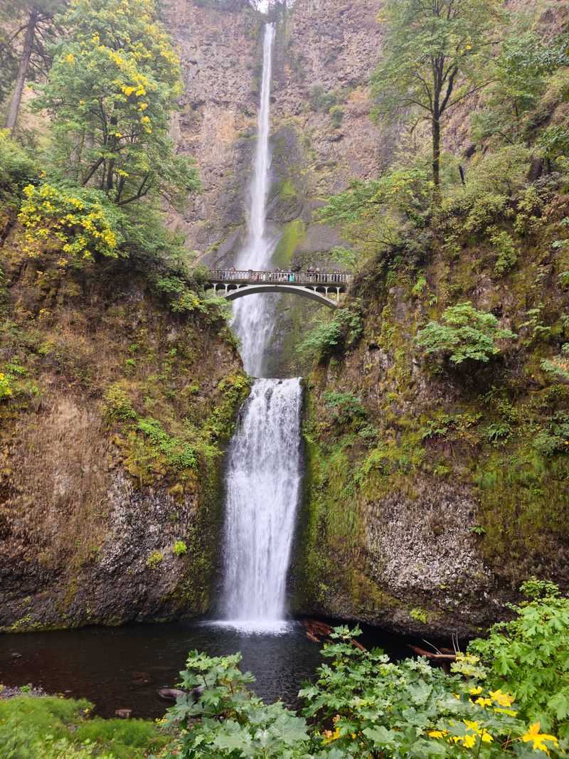
More than 90 waterfalls cascade down the steep walls of the Columbia River Gorge, creating one of the world’s greatest concentrations of year-round waterfalls.
Multnomah Falls, the crown jewel, plunges 620 feet in two tiers, making it Oregon’s tallest waterfall and one of the most visited natural attractions in the Pacific Northwest.
The historic Benson Bridge spans across the falls’ lower tier, providing close-up views of the thundering water and cool mist on your face.
A paved trail climbs from the base to the top of Multnomah Falls, gaining 700 feet in elevation over one mile.
The upper viewpoint looks down on the falls from above, offering a completely different perspective on this natural wonder.
Multnomah Falls Lodge, built in 1925, houses a restaurant, gift shop, and visitor information center at the waterfall’s base.
Nearby Wahkeena Falls, Horsetail Falls, and Latourell Falls each possess unique characteristics worth exploring.
The Wahkeena-Multnomah Loop combines several waterfalls into a 5-mile hike through old-growth forest.
Winter transforms these waterfalls into partially frozen sculptures with massive ice formations clinging to the cliffs.
Historic Highway 30 provides access to many waterfall trailheads, though recent wildfires temporarily closed some areas.
Check current conditions before visiting, as restoration work continues throughout the gorge.
The address for Multnomah Falls is 53000 E Historic Columbia River Highway, Bridal Veil, Oregon 97010.
Weekday visits, especially in early morning or late afternoon, help avoid the largest crowds.
The constant spray from waterfalls creates microclimates supporting unique moss and fern species.
Rainbows frequently appear in the mist on sunny days, adding extra magic to the already spectacular scenery.
The Columbia River Gorge National Scenic Area protects these waterfalls and surrounding forests for future generations to enjoy and appreciate.
Dear Reader: This page may contain affiliate links which may earn a commission if you click through and make a purchase. Our independent journalism is not influenced by any advertiser or commercial initiative unless it is clearly marked as sponsored content. As travel products change, please be sure to reconfirm all details and stay up to date with current events to ensure a safe and successful trip.