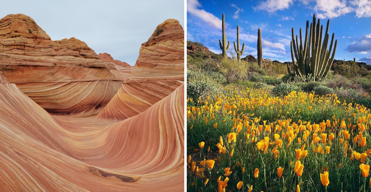
Think you know Arizona after the Grand Canyon and Monument Valley, think again.
The state hides remote canyons, quiet refuges, and historic enclaves where the silence feels like its own landmark.
These places reward careful planning, patient pacing, and a deep respect for fragile landscapes.
Pack extra water, check permits, and let the wide desert teach you how to slow down.
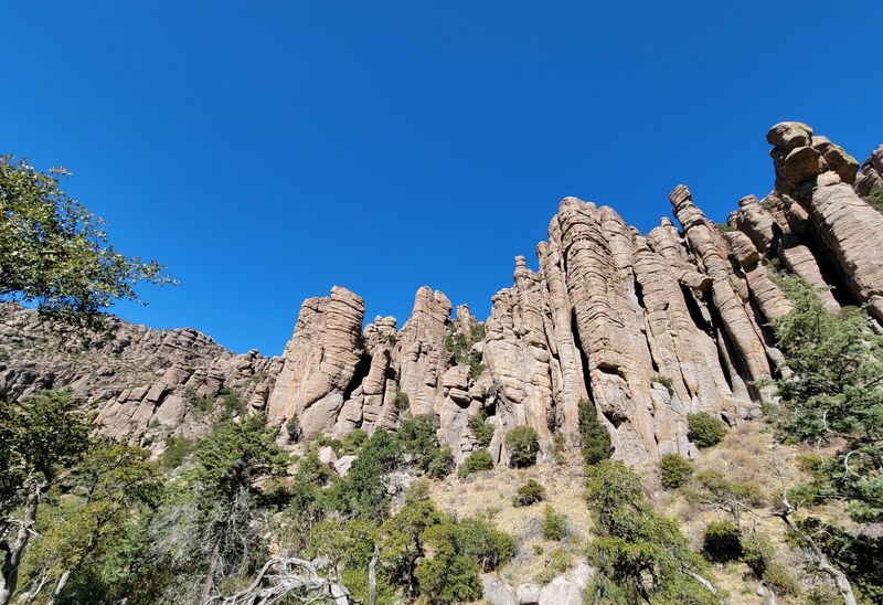
1. Chiricahua National Monument
Arizona is often associated with iconic landmarks such as the Grand Canyon and Monument Valley.
Yet the state also holds many lesser known desert destinations that showcase its geology, ecology, and cultural history.
Some are managed as national monuments or wildlife refuges, while others preserve historic sites or ghost towns.
These areas are generally less crowded than major attractions, offering opportunities for quieter exploration.
Because many of these places are remote and minimally developed, visitors should plan ahead, checking permit requirements, carrying sufficient water, and preparing for desert conditions.
This guide outlines several of Arizona’s hidden desert landscapes, with details on location, features, and practical notes for exploring them responsibly.
Curiosity often leads hikers to the labyrinth of stone at Chiricahua National Monument, where unusual pinnacles and balancing rocks have stood for ages.
The monument’s sky island ecosystem provides refuge for a remarkable range of plant and animal species that thrive above the desert floor.
Trails weave through rhyolite canyons and shaded fir pockets, revealing overlooks that rise above sculpted spires.
Spring and fall bring accessible paths and crisp air, while summer monsoons hush the valleys and sharpen the scent of pine.
Interpretive signs share stories of the Apache people and the region’s volcanic past that shaped these surreal formations.
Shuttle options and limited campsites encourage early planning, but the quiet holds even when parking areas fill.
Photography is best at first light when amber tones wrap the rock gardens and soft shadows emphasize texture.
Birdsong echoes across Echo Canyon, and the distant views toward Sulphur Springs Valley feel boundless.
Respect cryptobiotic soil and keep to signed routes, since delicate crusts can take years to recover.
The closest services lie in Willcox, so carry water, sun protection, and a map for the backcountry loops.
Address, 12856 E Rhyolite Creek Rd, Willcox, AZ 85643.
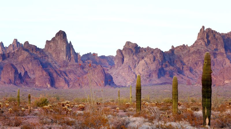
2. Kofa National Wildlife Refuge
Arizona often surprises travelers who leave the interstates and follow the thin lines that fold into distant ranges.
Kofa National Wildlife Refuge rewards that decision with sweeping vistas and a hush that settles over saguaro flats.
The Kofa Mountains rise in sharp profiles that glow when the sun edges low, guiding the eyes along ridgelines.
Wildlife uses the washes and bajadas as corridors, and careful observers sometimes catch movement on quiet mornings.
Roads are unpaved and rocky in places, so high clearance helps when storms reshape the track.
Navigation merits redundancy, with paper maps backing up devices that may drift in remote valleys.
Old mining remnants punctuate side canyons, where timbers lean and tailings fade into desert varnish.
Spring brings ocotillo blooms that lift color above gravel fans, though the refuge remains tranquil.
Nights feel immense, and the stars hang low enough to trace the mountain silhouette.
Leave no trace practices matter here, since fragile soils and sparse crusts recover slowly after footprints.
Expect few signs and fewer amenities, which keeps the experience rooted in self reliance and care.
Sound travels far, so speak softly and let the wind do most of the talking in broad basins.
Pack more water than seems necessary, and turn back before fatigue overwrites judgment on long spurs.
Keep an eye on weather that can build quickly over Castle Dome and descend without warning.
Photographers will appreciate late afternoon when shadows carve texture across columnar cacti.
Address, 356 W 1st St, Yuma, AZ 85364, refuge headquarters serves as a planning point before entry.
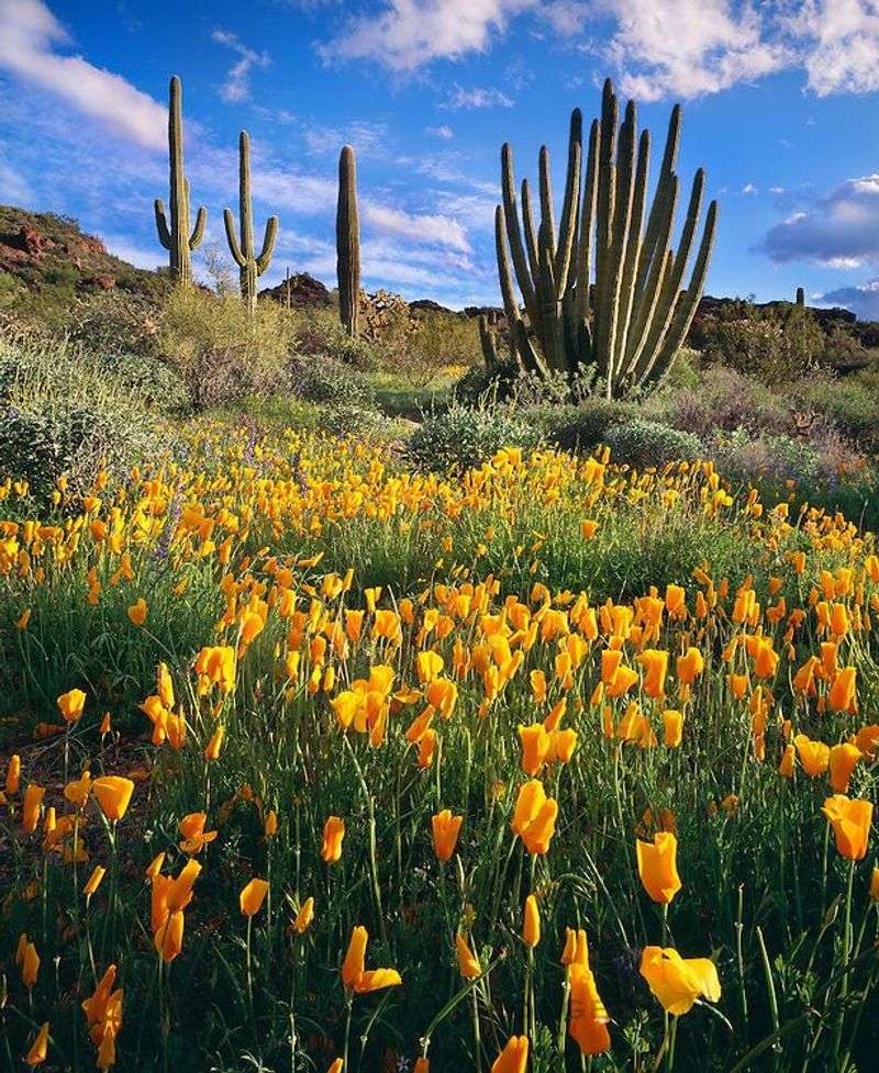
3. Sonoran Desert National Monument
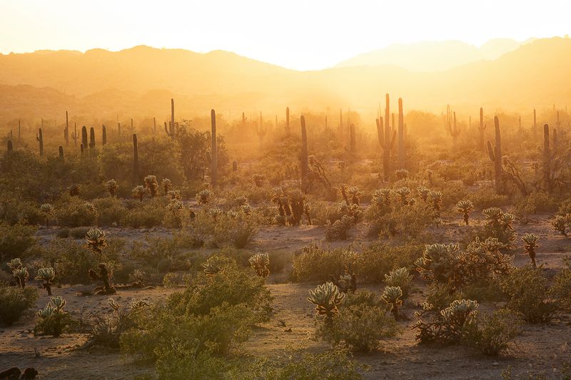
South of Phoenix the Sonoran Desert National Monument protects wide plains where saguaro communities feel almost endless.
Arizona’s signature cactus shares space with palo verde, cholla, and seasonal blooms that paint subtle color.
The monument spans varied microhabitats, so careful walking reveals birdlife tucked among spines and branches.
Facilities are sparse, and that simplicity keeps the soundscape gentle and uncluttered on most days.
Dirt roads reach trailheads that lead into drainages where shade appears in brief, welcome patches.
Bring maps and know your route, since junctions can look similar when light flattens in late afternoon.
Patient visitors may spot Gila woodpeckers tapping saguaros, or a tortoise sheltering under a mesquite.
Wildflower displays follow timely rains, pairing delicate petals with volcanic gravel and sandy fans.
Stargazing feels immersive, with horizons unbroken by buildings and a sky that keeps its dark.
Quiet hikes reward slow attention, revealing lizard tracks that stitch across crusted soils.
Expect few services, so plan water and rest stops with conservative margins in warm seasons.
Stay on established routes to protect biological soil crust that anchors this living desert.
Photography benefits from low sun and scattered clouds that shape soft gradients over ridges.
Monsoon months bring isolated storms that can make washes flow and tracks muddy within minutes.
The monument’s breadth invites exploration without rushing, letting each valley introduce itself on foot.
Address, Vekol Rd Access, off I 8 near Maricopa, AZ 85139, check current road conditions before travel.
4. Aravaipa Canyon Wilderness
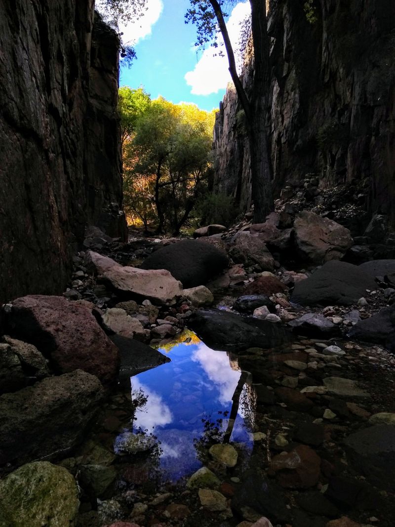
Aravaipa Canyon Wilderness threads a permanent stream through sheer walls that turn golden as morning arrives.
Arizona’s desert gives way to a ribbon of cottonwood shade and water that cools the air.
Permits cap entry and keep the canyon quiet, which helps wildlife settle into natural rhythms.
Most travel follows the creek, so expect wet feet and careful steps over gravel and cobbles.
Trails are informal, and navigation relies on understanding bends, side canyons, and landmarks above.
Carry a printed map along with a downloaded version, since signal fades after the last ranch gate.
Look for coatimundi tracks and listen for raptors that ride thermals above the narrow corridor.
Dense vegetation offers shade at intervals, then opens to pools where reflections sharpen the cliffs.
Move slowly to spot fish in clear runs and to avoid disturbing quiet eddies.
Weather can shift rapidly, and storms upstream may raise water levels with little warning.
Leave no trace is essential, including careful foot placement to protect stream banks and roots.
Photography thrives on diffused light that softens contrast and preserves detail on textured stone.
Autumn colors arrive along the water, laying copper tones against gray volcanic layers.
Plan footwear that drains, and stow electronics in dry bags that seal securely.
Pack out everything, and give wildlife space in tight sections where the canyon narrows.
Address, Aravaipa Canyon East Trailhead, 9000 Aravaipa Rd, Klondyke, AZ 85543, permit required before arrival.
5. Painted Rock Petroglyph Site
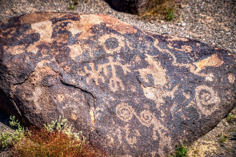
Painted Rock Petroglyph Site gathers basalt boulders into a low hill where symbols catch late sun.
Arizona history rests on these stones, etched by Indigenous artists whose lines still hold meaning.
The setting feels open, with broad desert plains rolling away toward distant low ranges.
A simple loop path guides visitors around panels without crowding the rock surfaces.
Interpretive signs provide helpful context while encouraging slow observation and respect for the site.
Photography works best with side light that reveals shallow carvings and ancient patina.
Please avoid touching the rock, since oils can darken surfaces and erase delicate contrast.
Campground spaces sit nearby, offering a quiet base for sunrise and twilight visits.
Bring shade and water, because facilities are limited and days can run long.
Silence settles after sunset, and the stars frame the petroglyph mound like a stage.
Tracks from small animals stitch around the site, and birds sometimes perch on the upper stones.
Stay on marked paths to protect the fragile desert pavement surrounding the hill.
Wind can lift fine dust, so lens filters and soft cloths help keep gear clean.
The approach road is short but unpaved, usually passable with careful driving.
Use restraint with lighting at night to reduce glare and guard the night sky.
Address, Painted Rock Petroglyph Site, 1404 S Painted Rock Dam Rd, Gila Bend, AZ 85337.
6. Cabeza Prieta National Wildlife Refuge
Cabeza Prieta National Wildlife Refuge covers an immense sweep of desert where quiet feels complete.
Arizona’s borderlands shine with volcanic cones, pale dunes, and wide basins that hold long light.
Permits are required, and visitors must review access rules that protect sensitive wildlife habitat.
Roads are rough and remote, so high clearance and full spares are wise companions.
Navigation calls for practiced skills, since intersections can be unsigned and distances deceptive.
Seasonal heat demands strict hydration planning and conservative daily goals across open terrain.
Watch the horizon for dust tails that mark distant vehicles or gusts brushing the flats.
Wildlife sightings can be brief, so glass with patience and scan shadowed slopes near dusk.
Leave gates as found and keep tracks on established routes to preserve fragile crusts.
Winds shape sand into temporary forms that reset with every strong weather shift.
Photography benefits from high contrast mornings when the cones cast crisp silhouettes.
Signals drop fast once past town, so share itineraries with a contact before departure.
Carry extra water and allow turn around time, since conditions change faster than expected.
Respect closures that support recovery for rare species and protect ongoing research areas.
Expect solitude that stretches for hours, and let that stillness guide your pace.
Address, Cabeza Prieta NWR Headquarters, 1611 N Second Ave, Ajo, AZ 85321, permits available with orientation.
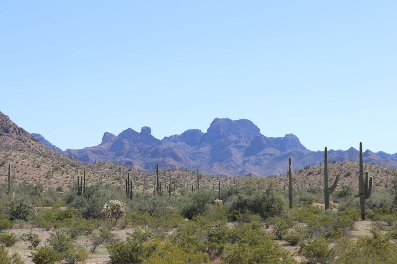
7. Organ Pipe Cactus National Monument
Organ Pipe Cactus National Monument protects the only dense stands of organ pipe cactus found in the United States.
Arizona’s southwestern corner blends cross border ecology with sweeping valleys and rugged volcanic hills.
Loop drives pass trailheads where short walks reveal clusters of columnar cacti and seasonal blooms.
Ranger programs add context about ecology and cultural history that ground the landscape in time.
Hikers will find quiet stretches where birds settle between spines and lizards warm on rocks.
Carry water and sun protection, since shade runs scarce outside the drainages and arroyos.
Winter light sharpens form, while spring lays color against basalt and tuff outcrops.
Camping areas provide a calm base for sunrise walks and late evening stargazing.
Road conditions can change after storms, so check updates before driving the longer loops.
Respect the desert by staying on signed paths that reduce erosion and protect living crust.
Photographers should look for low angles that sculpt ribbed cacti with gentle side light.
Binoculars help spot owls tucked into arms and kestrels perched on distant snags.
The monument remains quieter than larger parks, which suits travelers who prize reflection.
Maps from the visitor center support planning that balances mileage with daylight and weather.
Wildflowers appear when rains arrive, then fade as heat builds across the valley floor.
Address, 10 Organ Pipe Dr, Ajo, AZ 85321, visitor center serves as the best starting point.
8. Vermilion Cliffs National Monument, Arizona Section
Vermilion Cliffs National Monument, Arizona section, presents layered sandstone that changes tone with every step.
Arizona’s high desert opens here into slickrock, benches, and fins that fold into sculpted valleys.
Permits strictly limit entry to fragile zones, which keeps foot traffic light and views pristine.
Navigation requires confidence, because routes cross open rock with few markers beyond terrain features.
Weather shapes the day, and wind can race across plateaus faster than it seems.
Water sources are scarce, so plan generous reserves and protect them from heat.
Geology takes the spotlight, with bands that trace ancient environments in visible sequences.
Photographers chase soft clouds that add scale without stealing attention from the stone.
Shoes with grip matter, since angled slabs can feel slick after sand collects underfoot.
Leave only footprints on durable surfaces and give cryptobiotic crust a wide berth.
Expect long approaches that reward patience with immense silence and refined color gradients.
Sunrise and sunset extend the palette, then fade into a sky that holds deep stars.
Advance planning includes maps, permit windows, and backup options in case conditions change.
Travelers who like solitude will value the gentle pace these protections create.
Respect seasonal closures that support restoration and reduce pressure on sensitive species.
Address, Vermilion Cliffs National Monument, Paria Contact Station, US 89, Marble Canyon, AZ 86036.
9. Castle Dome Mountains and Mine Museum
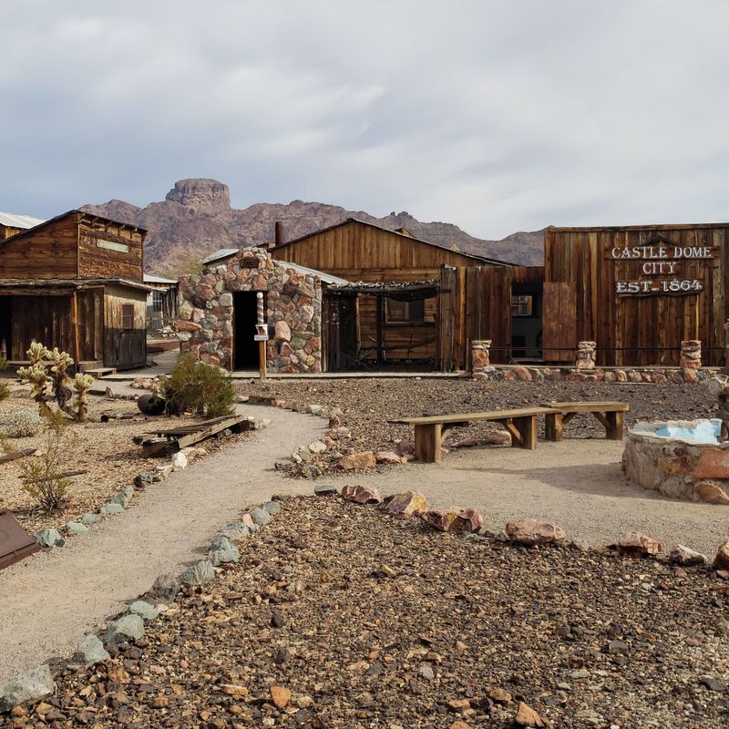
Castle Dome Mountains and Mine Museum blends rugged desert scenery with a carefully preserved ghost town experience.
Arizona’s mining past comes alive inside restored buildings that line dusty lanes beneath jagged peaks.
Exhibits display tools and artifacts that speak to daily work in remote camps.
Interpretive signs add context without overwhelming, letting the structures tell most of the story.
The surrounding range frames every view, and late light turns the ridges a smoky blue.
Short paths lead to overlooks where the desert spreads wide toward the river corridor.
Visitors should respect posted boundaries and avoid fragile remnants that could crumble with touch.
Carry water, since temperatures rise quickly and shade remains limited around the townsite.
Photography favors simple compositions, highlighting wood grain, tin roofs, and the open sky.
Wind sometimes moves through alleys with a low whistle that adds to the atmosphere.
The museum operates on set hours, so check times before driving out from Yuma.
Roads are paved most of the way, then transition to a manageable final stretch.
Nearby trails enter the mountains, offering a contrast between cultural history and raw geology.
Move slowly and listen for quail calls that skip through creosote and brittlebrush.
Leave no trace applies in town and outside it, protecting both artifact and habitat.
Address, Castle Dome Mine Museum, Mile Marker 55, US Hwy 95, Yuma, AZ 85365.
10. Tonto National Monument
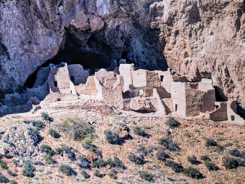
Tonto National Monument preserves Salado cliff dwellings that perch above a desert slope with long views.
Arizona’s uplands meet saguaro country here, and the contrast sets a memorable stage for exploration.
Two main sites sit in alcoves that stay shaded while the hills glow in sun.
Trails climb steadily, with benches where visitors can pause and take in the basin.
Rangers share cultural context that enriches the architecture and the surrounding plant communities.
Carry water and wear sturdy shoes, since gravel underfoot can roll on steeper sections.
Photography finds balance between stone masonry and the horizon that opens toward distant water.
Please respect closures inside rooms to protect plaster, wall edges, and original materials.
Wildflowers brighten the lower slopes when conditions align, then fade back into muted tones.
Birds use the alcove edges as perches, and their calls echo under the arching rock.
Slow walking reveals pottery fragments protected beneath glass in interpretive displays at the visitor center.
The small footprint of the park invites an unhurried visit that honors the setting.
Afternoons can feel warm even in cooler seasons, so plan shade breaks on benches.
Return down the path with care, since gravel can be slick on the descent.
Mind the cactus near the trail edge, which sometimes leans into the route with spines.
Address, Tonto National Monument, 26260 AZ 188, Roosevelt, AZ 85545, visitor center marks the start.
Dear Reader: This page may contain affiliate links which may earn a commission if you click through and make a purchase. Our independent journalism is not influenced by any advertiser or commercial initiative unless it is clearly marked as sponsored content. As travel products change, please be sure to reconfirm all details and stay up to date with current events to ensure a safe and successful trip.