You came for California’s big-name cascades, yet the state hides quieter waterfalls down trails that most travelers skip.
These routes trade long lines for ocean spray, fern canyons, and volcanic ledges that thunder after rain.
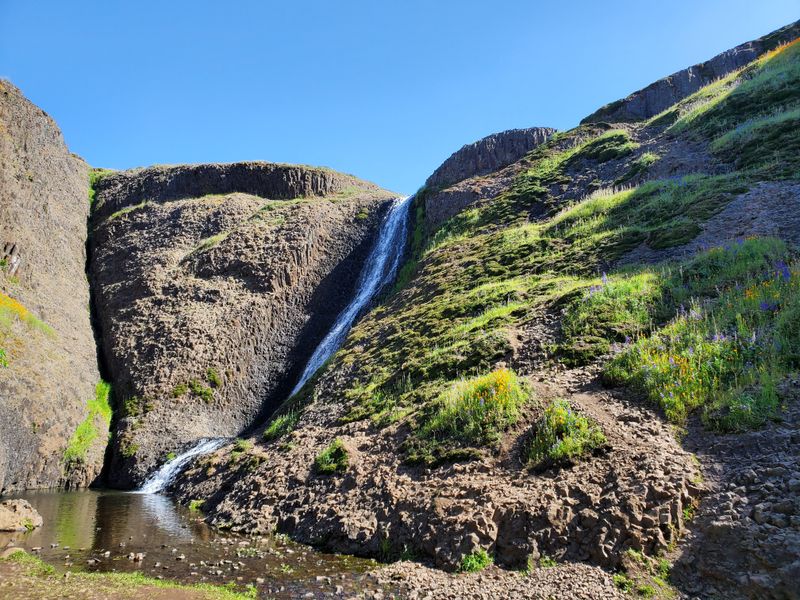
1. Alamere Falls, Point Reyes National Seashore
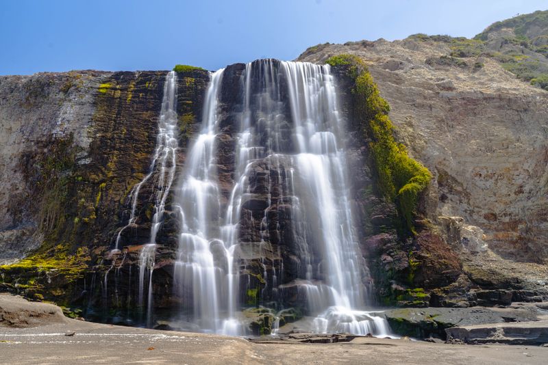
California’s waterfalls often mean crowds, yet Alamere Falls rewards those willing to time the tides and trace the bluffs.
You start on the Coast Trail near Palomarin, threading chaparral and coastal scrub with ocean views unfolding at every bend.
Bird calls, salt air, and a steady breeze set a rhythm that keeps you moving.
The approach grows sandy as Wildcat Beach comes into view, and the tidefall reveals itself with a hush that turns into a roar.
Freshwater spills over a layered cliff and lands on the beach, a rare sight along this coast.
Plan around low tide to walk the strand safely and see the full curtain.
Use sturdy shoes for the eroded descent near the final drop, where footing feels loose and slick.
Keep an eye out for seasonal closures after heavy rain, since bluff sections shift.
Arriving early earns quieter moments and an empty shoreline.
Spring paints the bluffs with wildflowers, while winter storms reshape the sand below the falls.
Seals sometimes surface offshore, and raptors patrol the ridgelines.
Respect posted signs that protect nesting habitat close to the trail.
You will not find amenities at the base, so bring water, layers, and a tide chart.
The return hike climbs gently with long looks at the Pacific.
Each step back confirms why a tidefall feels like California distilled to edge and ocean.
Address: Palomarin Trailhead, 9105 Mesa Rd, Bolinas, CA 94924.
Trail access lies within Point Reyes National Seashore boundaries with signed parking.
Check Point Reyes National Seashore alerts before you go for closures and updates.
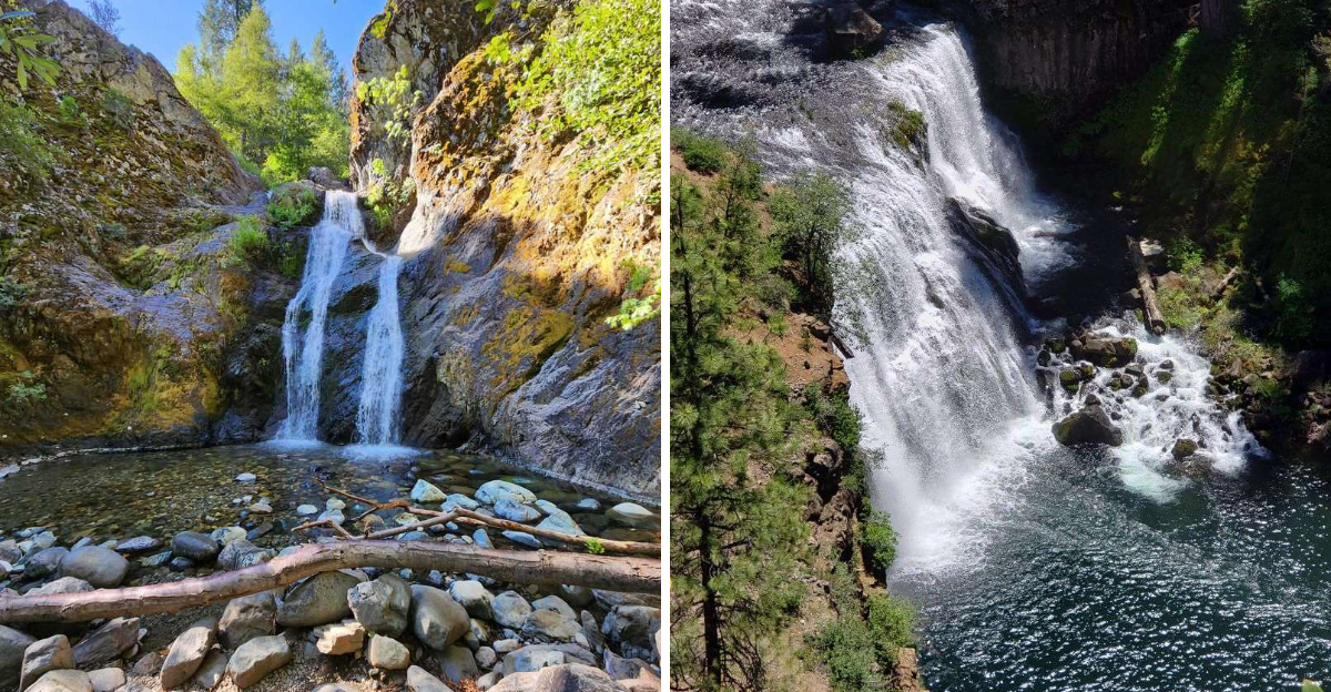
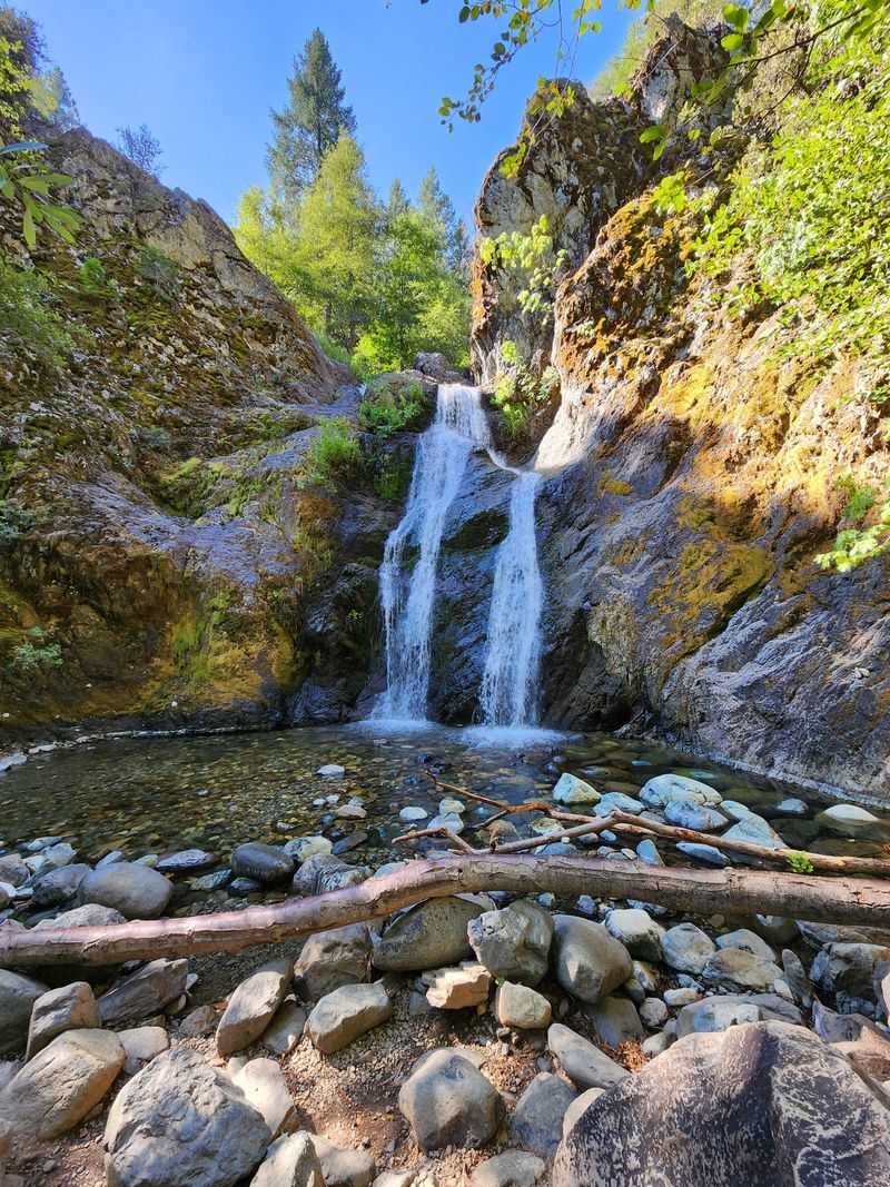
2. McCloud Falls, Shasta Trinity National Forest
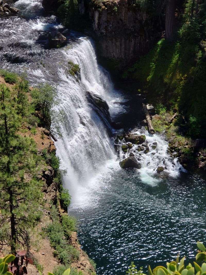
McCloud Falls strings three distinct drops along a turquoise river, each with its own mood and soundtrack.
Lower, Middle, and Upper Falls link by a riverside path that keeps the current in earshot.
The route feels like a gallery, with different angles unfolding at every turn.
Middle Falls spreads wide across dark basalt, throwing mist that cools the viewpoint.
Lower Falls curls into a deep pool rimmed by lava rock, where the water sounds round and steady.
Upper Falls narrows between cliffs, channeling force into a single plunge.
Ponderosa pine and incense cedar line the canyon, adding shade and a resin scent on warm days.
Short spur trails lead to overlooks with railings and open rock shelves.
The water’s clarity shifts with snowmelt, which often strengthens the flow.
Wayfinding stays straightforward thanks to clear signs and a well traveled path.
River access points appear regularly, though wet stones require cautious steps.
Bring layers because canyon breezes can feel cooler than the trailhead.
Interpretive panels share geology and cultural history of the McCloud corridor.
Photographers find even light in the morning, when the cliffs hold back glare.
Afternoons favor dramatic contrast across the spray.
Picnic tables sit near Lower Falls, and vault toilets serve popular stops along the road.
Snow can linger nearby, so check conditions before driving.
The sequence gives you choice, whether you linger at one drop or walk the full circuit.
Address: Fowler Public Camp, 523-100 McCloud River Loop, McCloud, CA 96057.
Trailheads also signposted along McCloud River Road near the falls.
Confirm Shasta Trinity National Forest updates for seasonal access notes.
3. Feather Falls, Plumas National Forest
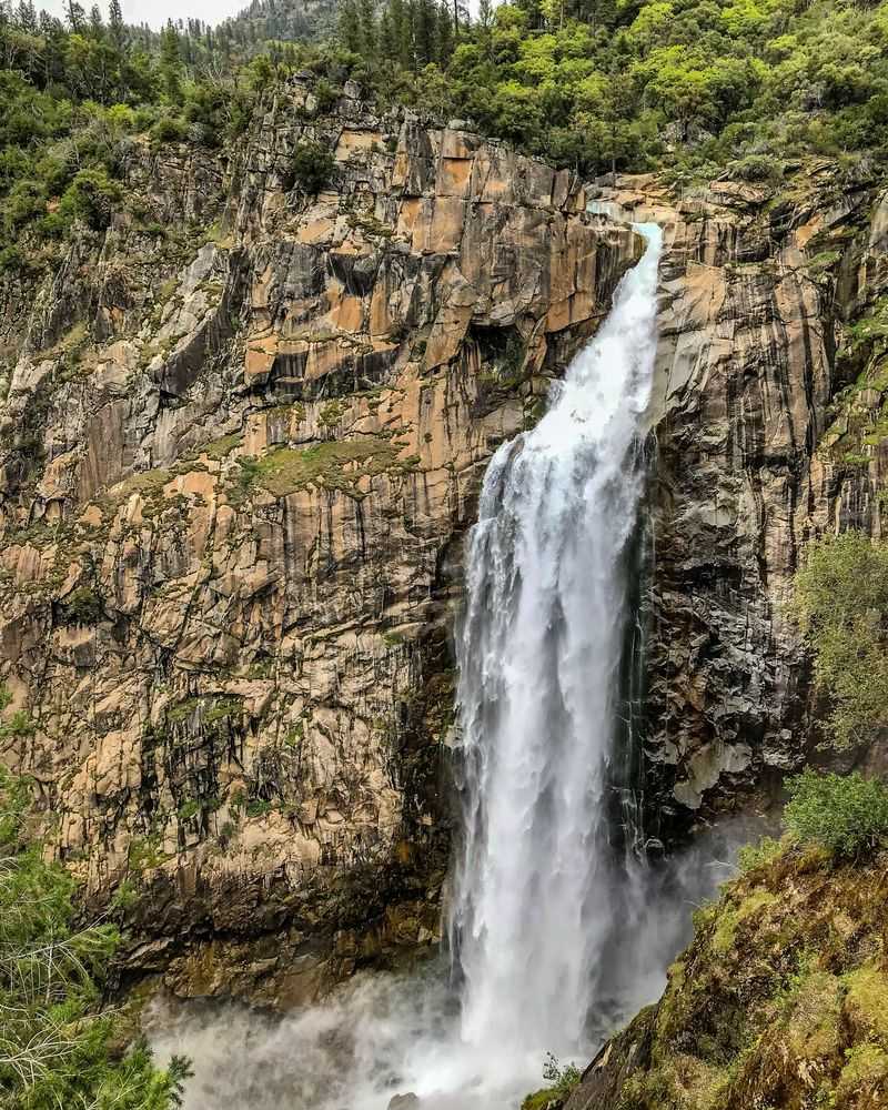
Feather Falls drops into a deep gorge that hums with wind, water, and recovering forest.
The overlook trail weaves through mixed conifers and open slopes where new growth follows past fire.
Switchbacks build a patient rhythm before the canyon opens wide.
The waterfall earns its name when sunlight turns the spray to drifting plumes.
Peak flow arrives with snowmelt, lending a fuller voice to the fall.
Even low water reveals the sheer wall and long vertical line.
Trail status can change, so confirm current conditions with the U.S. Forest Service before driving.
Sections may close for restoration, hazard trees, or weather.
Carry extra water because the route feels warm in exposed stretches.
The viewing platform gives a safe, sweeping perspective over the chute and downstream bend.
Hawks ride thermals across the gap while swifts skim the spray.
Sound grows louder near the rail, then fades as you step back into trees.
Expect uneven tread, roots, and rock that test ankle stability.
Trekking poles help on the descent and the return climb.
Seasonal wildflowers paint edges of the path with bright, low clusters.
Cell service is limited, so offline maps are useful.
Start early to bank shade on the outbound leg.
Pack layers since canyon winds shift quickly as clouds move.
Road access may include potholes, making unhurried driving worthwhile.
Parking fills on fair weather weekends, especially in spring.
Patience pays with more space at the overlook and quieter trail intervals.
Address: Feather Falls Scenic Trailhead, 9170 Lumpkin Rd, Oroville, CA 95966.
Verify Plumas National Forest alerts for closures or advisories.
Plan conservatively, and let the canyon set your pace.
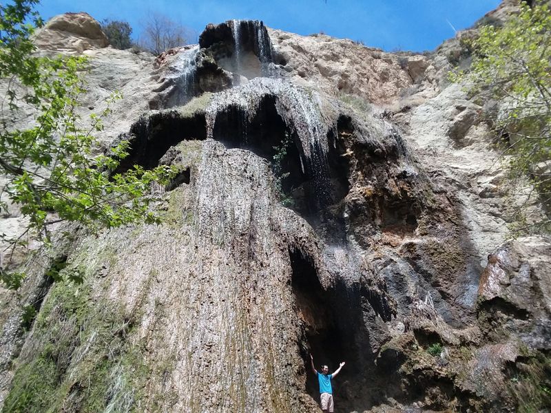
4. Faery Falls, Ney Springs Canyon
Faery Falls hides above the remains of Ney Springs Resort, where moss creeps over stone and echoes linger.
The route follows Ney Springs Creek under cedar and fir, with gentle grades that invite a steady pace.
Water sounds grow clearer before the canyon narrows.
The falls spill in slender ribbons over volcanic ledges into a shaded bowl.
Mist hangs lightly, softening ferns and slicking the rock.
Afternoon light filters through branches and blurs the cascade.
Historic traces appear as footings, pipes, and crumbled walls beside the trail.
These relics sit quietly, surrounded by new growth and leaf litter.
Stay on established paths to protect the creek banks.
Footing turns tricky near the water where algae coats stone.
Grippy soles make a noticeable difference on the final approach.
Step with patience and avoid hopping slick boulders.
The setting stays calm even during popular seasons, thanks to short approach and forest cover.
Birdsong carries along the canyon and masks nearby road noise.
Bring a small towel if you plan to sit close to the spray.
Photography favors a tripod and slow shutter in the dim understory.
Overcast days deliver even tones with rich greens.
Clear skies tend to produce bright highlights on wet rock.
Winter storms can down limbs and flood low points, so check local reports.
Summer lowers the flow yet reveals textured columns of rock.
Spring balances movement, color, and cooler air.
Address: Ney Springs Canyon Trailhead, Ney Springs Rd, Mount Shasta, CA 96067.
Limited parking sits along the unpaved approach near signed pullouts.
Confirm Shasta Trinity National Forest guidance for access and road conditions.
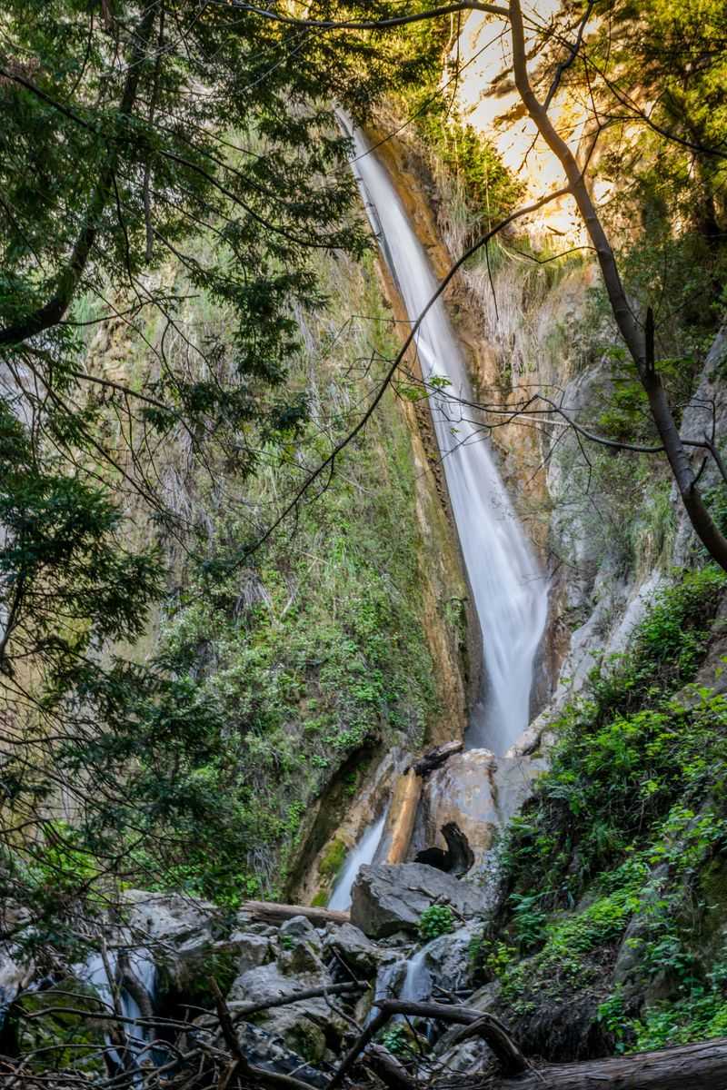
5. Whiskeytown Falls, Whiskeytown National Recreation Area
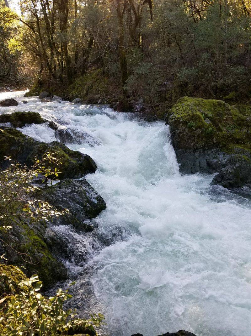
Whiskeytown Falls tucks behind forested ridges where the sound of water draws you forward step by step.
The trail climbs steadily along a shaded creek, with switchbacks that keep the grade manageable.
Birds flick through branches while the canopy cools the air.
The waterfall fans over tiers of rock that gleam even on gray days.
Spray drifts across the steps near the base and refreshes tired legs.
Every landing presents a new angle on the cascade.
Interpretive signs share how the falls slipped from common maps and returned to local memory.
Ecology notes introduce ferns, lichens, and resilient conifers.
The story deepens the view, turning scenery into a narrative.
Tread remains uneven with roots and stone, so supportive shoes are worth it.
Poles help on the descent, especially when wet leaves line the path.
Carry water because the climb feels longer in warm weather.
Spring brings lush growth along the creek banks, while summer offers dappled light.
Autumn clears the canopy and opens sky between branches.
Winter storms add volume and drama to the drop.
Trail etiquette keeps tight turns smooth when others pass.
Step aside on narrow sections to ease the flow.
Listen for the falls to gauge your distance without checking a map.
Visitor services sit near main roads, not at the base, so plan ahead.
The final viewpoint sits close enough for mist on your sleeves.
Photos work best in soft light that avoids glare.
Address: James K Carr Trailhead, Crystal Creek Rd, Whiskeytown, CA 96095.
Confirm Whiskeytown National Recreation Area alerts for closures.
Allow time to linger at the tiers before hiking out.
6. Escondido Falls, Malibu
Escondido Falls hides in a shaded Malibu canyon where sycamores lean over a well used path.
Seasonal rain decides the mood, from a gentle lace to a full green curtain.
The approach moves past creek crossings that turn playful after storms.
The lower tier sits in a grotto where moss glows emerald against pale stone.
Water braids over textured rock and pools softly below.
Sound bounces from the walls and hushes the canyon.
Reaching the upper tier requires careful scrambling that many visitors skip.
Respect signs that limit access during sensitive periods for habitat protection.
Good traction reduces slips on damp soil and rock.
Wildflowers dot the route in late winter when Southern California feels newly washed.
Summer narrows the flow yet keeps the grotto cool and inviting.
Shade makes this canyon feel kinder than exposed coastal ridges.
The trail crosses private drive segments where etiquette matters, so stay courteous and on route.
Dogs appear frequently, and leashes keep the corridor calm.
Pack water because canyon humidity can feel surprising.
Photography improves after clouds drift in and soften glare.
The falls frame well from low angles that emphasize height and moss.
Tripods fit best at off peak times when space opens.
Parking lies near the highway with posted rules and time limits.
Arrive early to skip congestion and enjoy quieter footing.
Return hikes move faster once you know each bend.
Address: Escondido Canyon Park, 27200 Winding Way, Malibu, CA 90265.
Check Mountains Recreation and Conservation Authority updates for closures.
The waterfall rewards patience and a weather eye on recent rain.
7. Three Chute Falls, Yosemite National Park
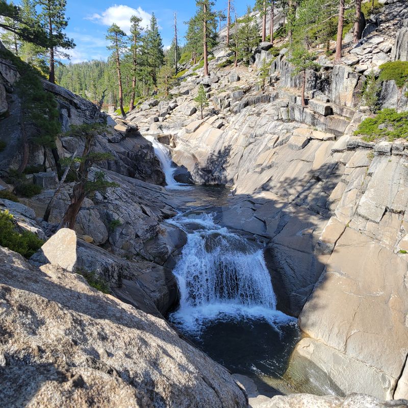
Three Chute Falls hides off the Mirror Lake corridor where Tenaya Creek slides over sculpted granite.
The stream splits into distinct lanes that rejoin in a polished basin.
Sound refracts between slabs and gives the spot a steady hiss.
Spring snowmelt wakes the chutes and amplifies the movement.
Late season leaves a smaller flow that exposes intricate rock.
Pools turn glassy in calm weather and reflect the walls.
The approach begins on the paved path toward Mirror Lake before shifting to rougher tread.
Short detours over granite require sure steps and dry soles.
Wet polish on rock can surprise even careful hikers.
This corner of the valley offers respite from busier marquee falls.
Birdsong carries across the water while pine resin hangs in the air.
The setting invites unhurried sitting and quiet sketches.
Pack layers because shade cools quickly when clouds slide in.
Storms raise the creek and can change safe crossings.
Check Yosemite alerts since access rules shift with conditions.
Photography benefits from an overcast sky that reduces glare on wet stone.
A wide lens captures all three lanes and the basin.
Early visits dodge reflections that blaze midday.
Trail etiquette matters on narrow granite ramps where passing takes care.
Keep distance from the water’s edge when flow runs fast.
Shoes with grip keep the scramble simple and calm.
Address: Mirror Lake Trailhead, Ahwahnee Dr, Yosemite Valley, CA 95389.
Verify Yosemite National Park updates for seasonal changes and shuttle routes.
The chutes reward patience, precise steps, and a pause to listen.
8. Phantom Falls, North Table Mountain Ecological Reserve
Phantom Falls appears on North Table Mountain when winter rains flip the switch.
The waterfall pours from a basalt lip into a round canyon lined with columns.
On dry days the cliff stands silent and bare.
The hike crosses open grasslands where wind moves the tall stems like water.
Volcanic outcrops break the plateau and frame long views.
Seasonal pools sparkle in low basins after storms.
Navigation follows use paths that braid across the mesa, so offline maps help.
Footing stays firm in dry weather and turns slick in mud.
Sun exposure makes hats and water feel essential.
Wildflower displays can edge the trail with color when conditions align.
The falls gain muscle after steady rain, then fade quietly.
Photographers work the rim for the best sightline into the bowl.
Cliff edges demand care, especially when grass hides loose rock.
Keep space from the lip and choose stable platforms.
Children and dogs need close attention in windy conditions.
Creek crossings rise quickly, so turn around if water runs swift.
The landscape shifts by hour, trading glare for glow near sunset.
Mornings bring calm air and clearer views across the valley.
Facilities are minimal, and packing out waste preserves the reserve’s delicate soils.
Signs request that visitors stay off sensitive areas around pools.
Respect seasonal closures that protect habitat and trails.
Address: North Table Mountain Ecological Reserve, Cherokee Rd Parking Area, Oroville, CA 95965.
Confirm California Department of Fish and Wildlife advisories before visiting.
The mesa rewards patience with sky, stone, and a waterfall that keeps its secrets.
9. Grotto Falls, Limekiln State Park
Grotto Falls sits in a narrow Big Sur canyon where redwoods filter light into green shade.
The path leaves the campground area and follows Limekiln Creek upstream.
Water sounds guide each bend as canyon walls draw closer.
The falls tumble into a small bowl framed by ferns and polished stone.
Spray cools the air and softens voices to a hush.
Low flow reveals sculpted channels that shine like wet glass.
Nearby lime kiln ruins offer a brief detour through local industrial history.
Moss climbs the brick and iron as forest growth reclaims edges.
The contrast deepens the sense of place within the grove.
Trail tread includes roots, boards, and occasional narrow bridges.
After rain, crossings rise and demand careful steps.
Stable shoes and a cautious pace keep everything smooth.
Morning visits deliver quiet light across the grotto walls.
Afternoon beams cut through the canopy and spark drifting mist.
Long exposures work well under even cloud cover.
Summer crowds concentrate near the beach, leaving the canyon calmer.
Winter rains boost the falls and perfume the air with redwood duff.
Spring fills the understory with bright new fronds.
Carry water and respect posted notices for wildlife and closures.
Stay on marked paths to protect fragile banks and roots.
Cell signal fades quickly once you enter the canyon.
Address: Limekiln State Park, 63025 CA-1, Big Sur, CA 93920.
Check California State Parks updates for current trail access and parking availability.
The short hike trades noise for a quiet grotto and cool spray.
Dear Reader: This page may contain affiliate links which may earn a commission if you click through and make a purchase. Our independent journalism is not influenced by any advertiser or commercial initiative unless it is clearly marked as sponsored content. As travel products change, please be sure to reconfirm all details and stay up to date with current events to ensure a safe and successful trip.