Heavy thunderstorms have wreaked havoc across California, causing severe flooding that has forced the closure of two major highways. Highways 395 and 14 are currently shut down due to dangerous road conditions, leaving many travelers stranded and seeking alternate routes. These closures are affecting thousands of motorists and creating significant safety concerns as roads wash away and mudslides block vital transportation corridors.
1. Major Highways Underwater as Thunderstorms Pound the Region
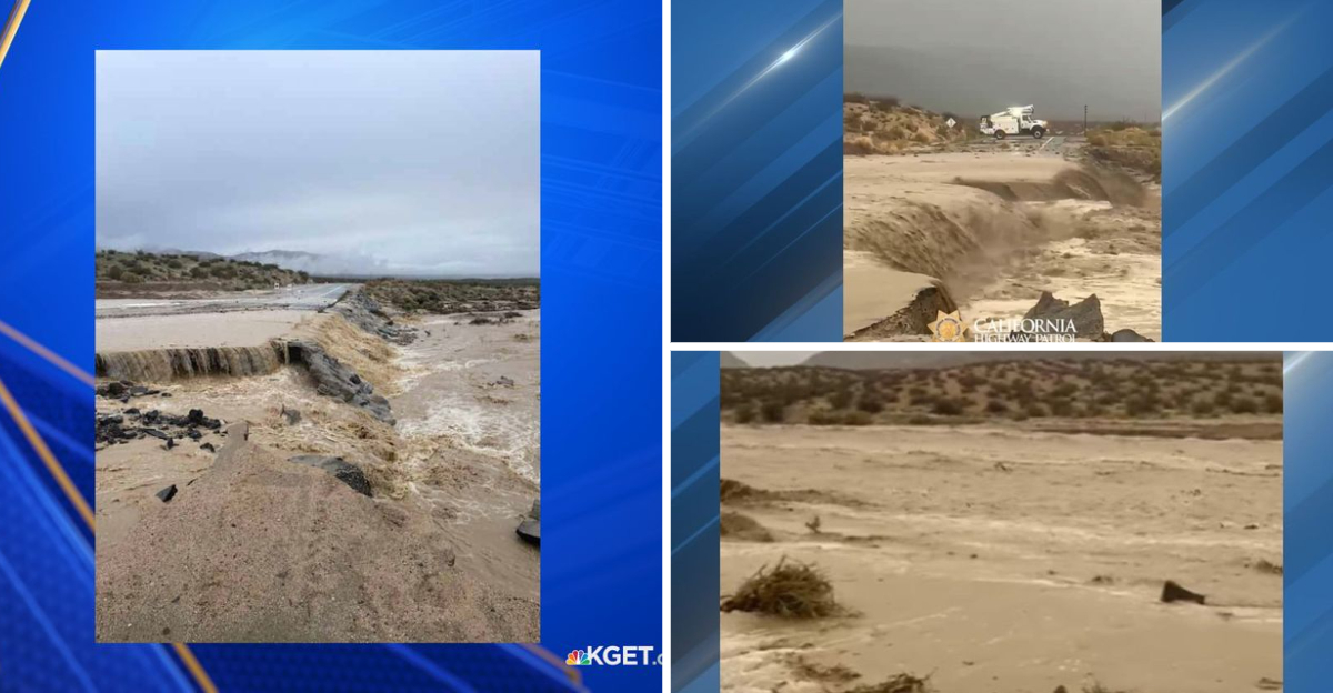
Highways 395 and 14 have transformed from busy travel corridors into impassable waterways after recent thunderstorms unleashed torrential rain across the area. The California Highway Patrol (CHP) Mojave division reports that Highway 14 is completely closed in both directions near Jawbone Canyon. Similarly, Highway 395 has been shut down near Randsburg due to extensive flooding.
What’s particularly alarming is how quickly the situation deteriorated. Flash floods swept across the roadways with little warning, leaving some drivers scrambling to reach higher ground. Water rushing across the highways has washed away portions of the road surface, making travel impossible even for emergency vehicles.
Though summer storms aren’t uncommon in this region, the intensity of this weather system caught many by surprise. Local authorities are monitoring water levels and road integrity hour by hour.
2. Road Washouts Create Dangerous Detours for Travelers
Redrock Randsburg Road, a crucial connector between Highway 14 and Garlock Road, has been completely washed away by raging floodwaters. This destruction has eliminated a vital alternate route for stranded travelers, complicating an already challenging situation. Meanwhile, a significant mudslide has blocked Highway 14 at Rogers Road, forcing officials to divert northbound traffic to eastbound Highway 58.
If you’re planning travel through these areas, you’ll need to prepare for extensive detours. The situation remains fluid as crews assess damage throughout the region. Some travelers have reported detour times adding 2-3 hours to their journeys.
Weather forecasters warn that additional rain could further deteriorate conditions in coming days. Local residents describe this as the worst flooding they’ve witnessed in decades, with some comparing it to the devastating storms of 1997.
3. Safety Recommendations as Recovery Timeline Remains Uncertain
Though everyone wants to know when these vital highways will reopen, officials haven’t provided a timeline yet. The extensive damage requires thorough engineering assessments before repairs can even begin. Your best strategy is to completely avoid traveling in these areas if possible.
For those who must travel, monitor the California Highway Patrol’s social media accounts and local news for real-time updates. Many travelers have found themselves stranded after relying on outdated navigation app information. Keep emergency supplies in your vehicle if travel is absolutely necessary – water, food, blankets, and a fully charged phone could make a critical difference.
Highway maintenance crews are working around the clock, but nature’s destruction won’t be quickly reversed. When routes eventually reopen, expect reduced speeds and ongoing construction that could continue for weeks or months.
Dear Reader: This page may contain affiliate links which may earn a commission if you click through and make a purchase. Our independent journalism is not influenced by any advertiser or commercial initiative unless it is clearly marked as sponsored content. As travel products change, please be sure to reconfirm all details and stay up to date with current events to ensure a safe and successful trip.