Planning out hiking trips across Texas for 2026 started to feel less like making a list and more like connecting dots on a map.
One route leads into rocky desert terrain, another climbs into sweeping mountain views, and another disappears into a shaded canyon where water cuts through stone.
Texas hiking covers more ground than most people realize, moving from granite domes to forested trails and wide open stretches that feel endless in the best way. Some paths are all about the climb and the view at the top, others reward you with water, shade, and quiet moments along the way.
These ten trails show just how much range the state offers, all within a single season.
1. Old Baldy Trailhead (Garner State Park)
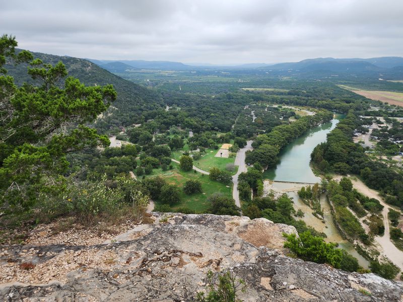
Standing at the base of Old Baldy early in the morning, you can already feel the anticipation building. This trail isn’t long, but it delivers one of the best payoffs in the Hill Country.
The climb covers just over a mile, gaining about 300 feet in elevation, which might not sound like much until you’re halfway up and your calves start reminding you they exist.
The path begins gently enough, winding through juniper and oak trees that provide scattered shade. As you gain elevation, the vegetation thins out and the limestone bedrock becomes more prominent underfoot.
Watch your step on loose rocks, especially if you’re hiking after recent rain. The views start opening up about halfway through, teasing what’s waiting at the summit.
Once you reach the top, the panorama spreads out in every direction across the Frio River valley. It’s the kind of view that makes you forget about the sweat and the effort.
Early morning or late afternoon light paints the hills in shades of gold and purple that photographs never quite capture right. Bring water, wear sturdy shoes, and maybe pack a snack to enjoy at the top while you catch your breath.
Address: Garner State Park Rd, Concan, TX 78838
2. McKittrick Canyon Trail (Guadalupe Mountains National Park)
McKittrick Canyon feels like it shouldn’t exist in West Texas. The contrast hits you immediately when you step onto the trail and hear water trickling through a landscape otherwise defined by desert and rock.
This canyon harbors a microclimate that supports trees and plants you wouldn’t expect to find anywhere near the Chihuahuan Desert.
The trail follows McKittrick Creek for about 2.3 miles to Pratt Cabin, a historic stone structure that once served as a vacation retreat. The path stays relatively flat and easy, making it accessible for most fitness levels.
What makes this hike special isn’t the challenge but the scenery. Bigtooth maples, Texas madrones, and ponderosa pines create a canopy that transforms into a riot of reds, oranges, and yellows during fall.
If you visit in autumn, you’re competing with crowds who come specifically for the foliage. Spring offers wildflowers and flowing water without the congestion.
Summer can be brutally hot, so start early if you’re hiking between June and August. The canyon walls rise dramatically on both sides, creating natural frames for the creek below.
Beyond Pratt Cabin, the trail continues to the Grotto and eventually to McKittrick Ridge, but most day hikers turn around at the cabin. The entire experience feels surprisingly gentle for such a rugged park.
Address: Dell City, TX 79847
3. Guadalupe Peak Trail (Guadalupe Mountains)
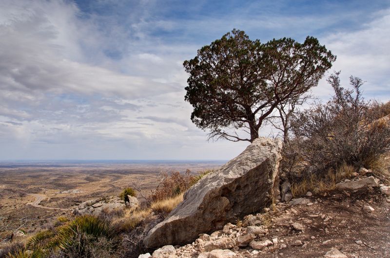
Guadalupe Peak doesn’t mess around. At 8,751 feet, it’s the highest point in Texas, and the trail makes you earn every single foot of that elevation.
The round trip covers 8.5 miles with over 3,000 feet of gain, which translates to a full day of hiking that’ll test your legs and your lungs.
Starting from the Pine Springs trailhead, the path begins climbing almost immediately through a series of switchbacks. The lower sections wind through scrubby vegetation and scattered boulders, offering limited shade.
As you ascend, the landscape shifts to include more pines and the air gets noticeably thinner and cooler.
Around the halfway point, many hikers start questioning their life choices. The relentless uphill grind combined with the exposed sections can feel overwhelming, especially on hot days.
But the views keep expanding with each switchback, providing motivation to keep pushing upward. The final approach to the summit involves some scrambling over rocks, nothing technical but enough to require attention and care.
The summit itself features a stainless steel monument marking the highest point in the state. On clear days, the views extend across the Chihuahuan Desert into New Mexico.
Bring plenty of water, start early to avoid afternoon thunderstorms, and don’t underestimate this climb just because it’s in Texas.
Address: Dell City, TX 79847
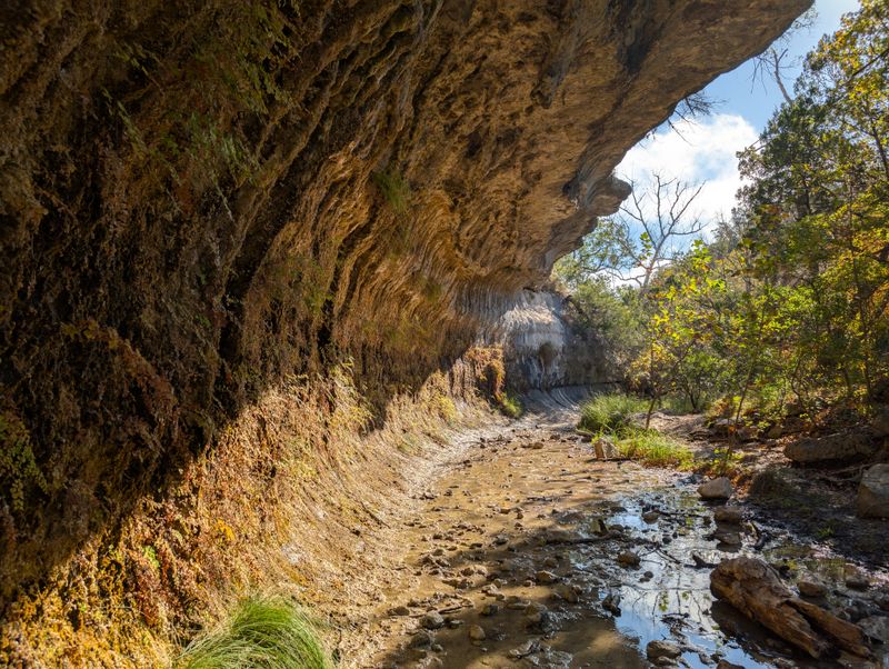
4. Santa Elena Canyon Trail
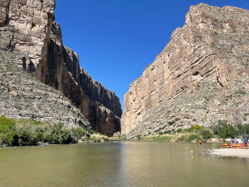
Walking into Santa Elena Canyon feels like entering a cathedral carved by the Rio Grande over millions of years. The limestone walls rise 1,500 feet straight up on both sides, creating a narrow corridor where the river flows between Texas and Mexico.
The scale of it catches everyone off guard the first time they see it.
The trail itself is short, just 1.7 miles round trip, but it includes a somewhat challenging start. You have to cross Terlingua Creek, which can range from ankle-deep to impassable depending on recent rainfall.
Once across, the path climbs a series of stone steps built into the canyon wall before leveling out along a ledge.
As you walk deeper into the canyon, the walls close in and the temperature drops noticeably. The river flows quietly below, and the silence gets broken only by occasional bird calls echoing off the rock faces.
The trail ends at a point where the canyon narrows dramatically, making it impossible to continue without swimming or boating.
Late afternoon light creates incredible shadows and colors on the canyon walls, making it a favorite time for photographers. Bring water shoes if you plan to cross the creek, and check water levels before you go.
This trail shows you Big Bend at its most dramatic without requiring a multi-day backcountry commitment.
Address: Terlingua, TX 79852
5. Gorman Falls (Colorado Bend State Park)
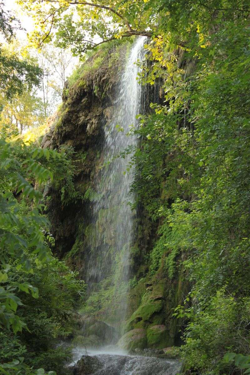
Gorman Falls might be the most beautiful secret in the Texas Hill Country. Getting there requires a 3-mile hike each way along the Gorman Falls Trail, which follows the Colorado River through rugged terrain.
The path isn’t particularly difficult, but it’s rocky and uneven enough to demand attention with every step.
The trail winds through juniper and oak woodlands, occasionally opening up to views of the river below. During spring, wildflowers dot the landscape, adding splashes of color to the otherwise muted greens and browns.
The temperature can climb quickly in summer, so most experienced hikers tackle this one early in the morning or later in the afternoon.
When you finally round the last bend and see the falls, the effort suddenly makes complete sense. Water cascades 70 feet down a travertine cliff covered in emerald green moss, ferns, and other vegetation that thrives in the constant mist.
The whole scene looks almost tropical, completely out of place in the middle of Texas.
You can’t swim at the falls themselves, but there are swimming holes elsewhere in the park if you need to cool off after the hike. The trail can get muddy and slippery after rain, and parts of it require scrambling over rocks.
Wear good hiking shoes and bring more water than you think you’ll need for the six-mile round trip.
6. Hueco Tanks State Park & Historic Site
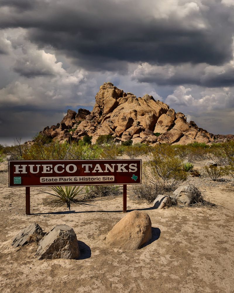
Hueco Tanks sits in the desert outside El Paso, but it’s nothing like the flat, barren landscape you might expect. Massive syenite rock formations rise from the desert floor, creating a maze of boulders, caves, and natural water catchments that have attracted humans for thousands of years.
The name comes from the Spanish word for hollow, referring to the rock depressions that collect and hold rainwater.
Hiking here requires a guided tour for most of the park, which limits crowds and protects the incredible concentration of Native American pictographs covering the rocks.
These ancient paintings and carvings date back over 10,000 years, making Hueco Tanks one of the most significant archaeological sites in North America.
The guides share stories about the symbols and the people who created them, adding context that transforms the hike into something more than just exercise.
The terrain involves scrambling over and between boulders, squeezing through narrow passages, and occasionally using your hands to climb. It’s more adventurous than a traditional trail hike, which is part of the appeal.
The rock formations create natural shade and channels that stay surprisingly cool even on hot days.
Reservations are required and spots fill up quickly, especially during cooler months. The park also attracts rock climbers from around the world, so don’t be surprised to see people scaling the boulders.
Wear closed-toe shoes with good grip and bring water.
Address: 6900 Hueco Tanks Road No. 1, El Paso, TX 79938
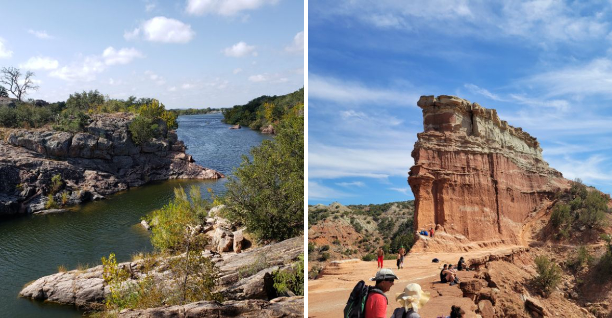
7. Lighthouse Trail (Palo Duro Canyon State Park)
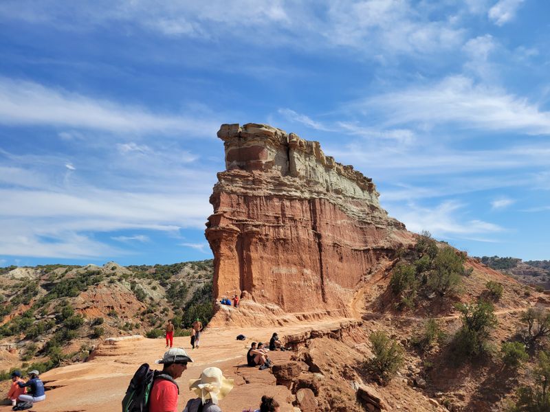
The Lighthouse Trail takes you to the most iconic rock formation in Palo Duro Canyon, the second largest canyon system in the United States. The hike covers six miles round trip across relatively flat terrain, but the exposure and distance make it more challenging than the elevation profile suggests.
There’s almost no shade along the entire route, which means timing matters significantly.
Starting from the trailhead near the campground, the path leads across the canyon floor through red dirt and scrubby vegetation. The layered rock walls of the canyon rise on all sides, displaying millions of years of geological history in bands of red, orange, and white.
The colors shift throughout the day as the sun moves across the sky, creating different moods and photographic opportunities.
The Lighthouse itself is a 75-foot tall rock spire that stands apart from the canyon walls, shaped by erosion into something that vaguely resembles its namesake. Getting close to it requires a short scramble up a rocky slope.
Most hikers spend time at the base taking photos and enjoying the views before making the return trip.
Summer temperatures regularly exceed 100 degrees, making this hike genuinely dangerous during midday. Spring and fall offer the best conditions, with cooler temperatures and occasional wildflowers.
Bring at least two liters of water per person, wear sun protection, and start early. The trail gets busy on weekends, but the canyon’s vastness absorbs the crowds.
8. Enchanted Rock Summit Trail
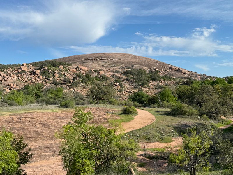
Enchanted Rock dominates the landscape like a massive pink granite whale breaching from the Hill Country. The dome rises 425 feet above the surrounding terrain, and the Summit Trail takes you straight up its smooth, sloping face.
The hike is only about a mile to the top, but the constant upward angle on exposed rock makes your legs burn quickly.
What makes this climb unique is the surface itself. Unlike traditional dirt trails, you’re walking directly on the granite dome, which can be slippery when wet and scorching hot in summer.
The rock is worn smooth in places by countless footsteps, while other sections feature rough crystals that provide better traction. There are painted markers to keep you on the safest route, though experienced hikers sometimes wander off to explore different approaches.
The views from the summit stretch for miles across the Hill Country, with other smaller granite domes visible in the distance. On clear days, you can see the skyline of Austin far to the east.
The summit itself is surprisingly spacious, with plenty of room to spread out and rest before heading back down.
Recent expansion of the park added thousands of new acres and additional trails, but the Summit Trail remains the main attraction. Reservations are required for entry, and weekends sell out weeks in advance.
The rock retains heat, so early morning hikes offer the most comfortable temperatures and the best light for photography.
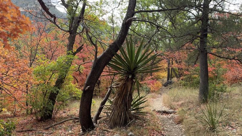
9. Lost Maples State Natural Area
Lost Maples earned its name from the isolated stands of bigtooth maples that somehow thrive in the dry Hill Country, far from their usual mountain habitats.
These trees put on a spectacular fall color show that draws visitors from across the state, transforming the park into a sea of reds, oranges, and yellows during October and November.
The East Trail is the most popular route, covering about 4.8 miles round trip through the heart of the maple groves. The path follows a creek through a canyon, crossing the water several times on stepping stones and low-water crossings.
During peak fall color, the trail can get crowded, but the canyon is beautiful enough to make the company tolerable.
Spring offers a completely different experience with wildflowers carpeting the hillsides and the creek running higher and faster. Summer is quiet and hot, with most of the maples providing welcome shade along the creek.
Winter hiking reveals the underlying structure of the landscape without the distraction of foliage.
The trails at Lost Maples vary in difficulty, with some climbing onto the surrounding ridges for views across the valleys. The terrain includes rocky sections that require careful foot placement and occasional steep grades.
Cell service is spotty throughout the park, so download maps before you arrive and let someone know your plans. Entrance fees apply and parking fills up early during peak fall weekends.
Address: 37221 RM 187, Vanderpool, TX 78885
10. Devil’s Waterhole Trail
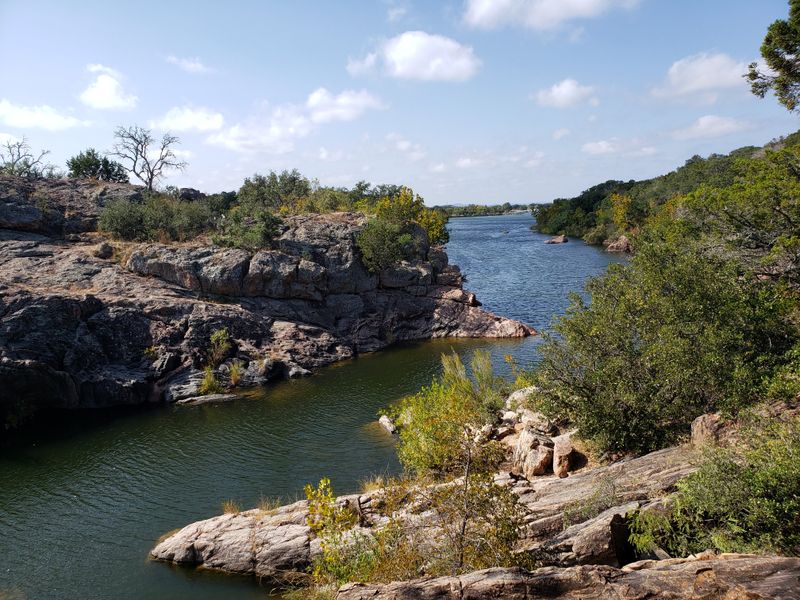
Devil’s Waterhole Trail offers something different from typical Texas hiking experiences by combining lakeside walking with pink granite boulders and swimming opportunities.
The trail loops about a mile around a particularly scenic section of Inks Lake, where the water stays relatively constant year-round thanks to upstream dam control.
The path winds over and around massive granite formations that glow pink in the right light, creating a landscape that feels more like a beach than a traditional hiking trail. In several spots, the trail leads directly to the water’s edge where you can wade in or jump off rocks into deep pools.
During summer, these swimming spots become the main attraction, with hikers taking breaks to cool off before continuing around the loop.
The terrain is easy overall but requires some rock scrambling and attention to footing. The granite can be slick near the water, and there are no guardrails or barriers between the trail and some significant drop-offs.
Kids love exploring the rocks and searching for small caves and crevices, but supervision is important near the water.
Spring and fall provide ideal hiking weather without the summer crowds. Wildflowers bloom among the rocks in March and April, adding color to the already photogenic landscape.
The trail connects to other longer paths in the park if you want to extend your hike beyond the waterhole loop. Bring water shoes if you plan to explore the swimming areas.
Address: PJWQ+7Q, Buchanan Dam, TX 78611
Dear Reader: This page may contain affiliate links which may earn a commission if you click through and make a purchase. Our independent journalism is not influenced by any advertiser or commercial initiative unless it is clearly marked as sponsored content. As travel products change, please be sure to reconfirm all details and stay up to date with current events to ensure a safe and successful trip.