Rolling hills covered in wildflowers, winding roads that disappear into the horizon, and small towns that feel like stepping back in time all wait for you in the Texas Hill Country.
This region offers some of the most beautiful driving routes in the entire state, where every turn reveals something new to explore.
Whether you’re chasing waterfalls, tasting local wines, or hunting for antiques in historic downtown squares, these drives promise more than just scenery.
Pack your cooler, fill up the tank, and get ready to discover why the Hill Country remains one of Texas’ most beloved destinations for road trippers who love taking the long way home.
1. Willow City Loop Near Fredericksburg
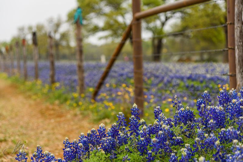
Wildflower season transforms this thirteen-mile backroad into one of the most photographed drives in Texas.
Starting just north of Fredericksburg, Willow City Loop winds through private ranch land where bluebonnets, Indian paintbrush, and pink evening primrose blanket the hillsides from late March through April.
The narrow road climbs and dips through limestone outcroppings and sprawling live oak trees that have stood for centuries.
Photographers pull over at nearly every bend to capture the explosion of color against the rugged Hill Country backdrop.
Families spread picnic blankets on the roadside while kids run through fields of flowers that reach their knees.
The loop connects back to Ranch Road 1323, creating a perfect circle that takes about an hour to drive without stops.
But most visitors spend half a day here, pausing repeatedly to soak in the views and snap photos.
After completing the loop, head into Fredericksburg for German-inspired cuisine and browse the antique shops lining Main Street.
The town’s pioneer history comes alive in museums and preserved buildings that tell stories of German immigrants who settled here in the 1800s.
Wine enthusiasts can visit several tasting rooms within walking distance of downtown.
This drive proves that sometimes the journey matters more than the destination, especially when nature puts on such a spectacular show.
Just remember that the road passes through private property, so respect the land and stay on public right-of-ways when stopping.
2. Devil’s Backbone Scenic Drive From Wimberley To Blanco
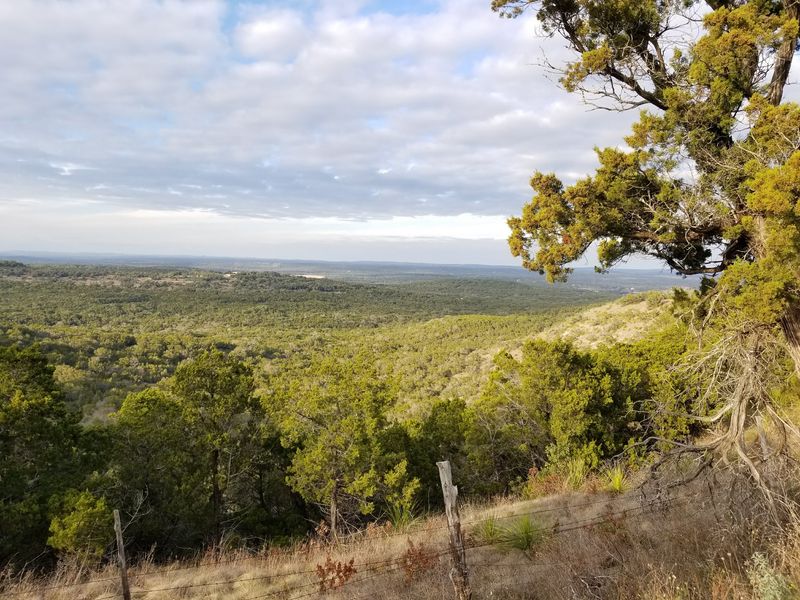
Perched along a ridgeline that offers sweeping views in every direction, Ranch Road 32 earned its dramatic nickname honestly.
The route stretches from Wimberley to Blanco, following the spine of a narrow ridge that drops steeply on both sides.
Early settlers named it Devil’s Backbone because the treacherous terrain challenged even the most experienced travelers.
Today, the paved road makes the journey much easier, but the views remain just as breathtaking.
Pull into the overlook area to gaze across miles of undeveloped Hill Country that looks much like it did two hundred years ago.
Hawks circle overhead while deer graze in the valleys below, oblivious to the cars passing above.
The drive takes only twenty minutes end to end, but plan to linger at the scenic overlook where interpretive signs explain the geological forces that created this unique landscape.
Wimberley serves as the perfect starting point, with its charming town square and the famous Blue Hole swimming area just minutes away.
After conquering the Backbone, explore Blanco’s historic courthouse square where local artisans sell handmade goods on weekends.
The Blanco River flows right through town, offering cool relief on hot summer days.
Combine this drive with a stop at one of the many natural swimming holes that dot the area.
The contrast between the elevated ridge views and the shaded creek valleys creates a perfect Hill Country experience in a single afternoon.
3. Three Sisters Route Through Comfort, Sisterdale, And Sister Creek
Three tiny communities connected by quiet farm roads create a driving loop that feels like discovering a secret corner of Texas.
Start in Comfort, where German settlers built limestone buildings in the mid-1800s that still stand today along High Street.
The town refused to fly the Confederate flag during the Civil War, making it one of the few Union-loyal settlements in Texas.
Browse antique stores housed in these historic structures before heading northwest toward Sisterdale.
This unincorporated community consists of little more than a few scattered homes and the remnants of a once-thriving settlement.
German freethinkers established Sisterdale in the 1840s, creating a community known for its intellectual pursuits and progressive ideas.
Though most buildings are gone, the peaceful countryside and gurgling Sister Creek still charm visitors who make the journey.
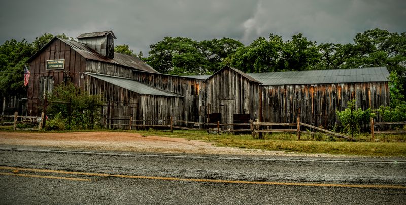
Continue along the winding roads to Sister Creek Vineyards, where you can taste wines while sitting on a porch overlooking the estate.
The tasting room occupies a restored cotton gin, blending history with modern winemaking.
Loop back toward Comfort through ranch land where longhorn cattle graze beneath massive pecan trees.
Stop at Comfort Cellars Winery right in town to compare their offerings with what you tasted earlier.
The entire route covers less than thirty miles but transports you through layers of Hill Country history.
Pack a lunch to enjoy at one of the roadside parks, or grab a meal at one of Comfort’s small cafes that serve homestyle cooking.
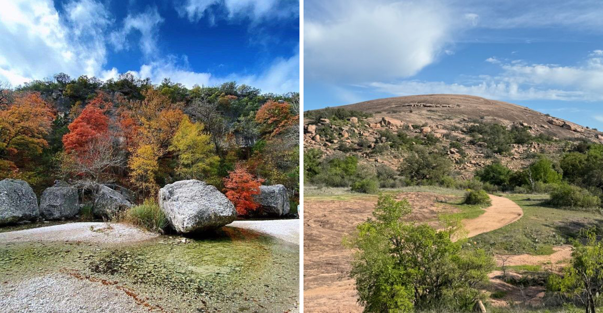
4. Enchanted Rock Loop Via Llano And Mason
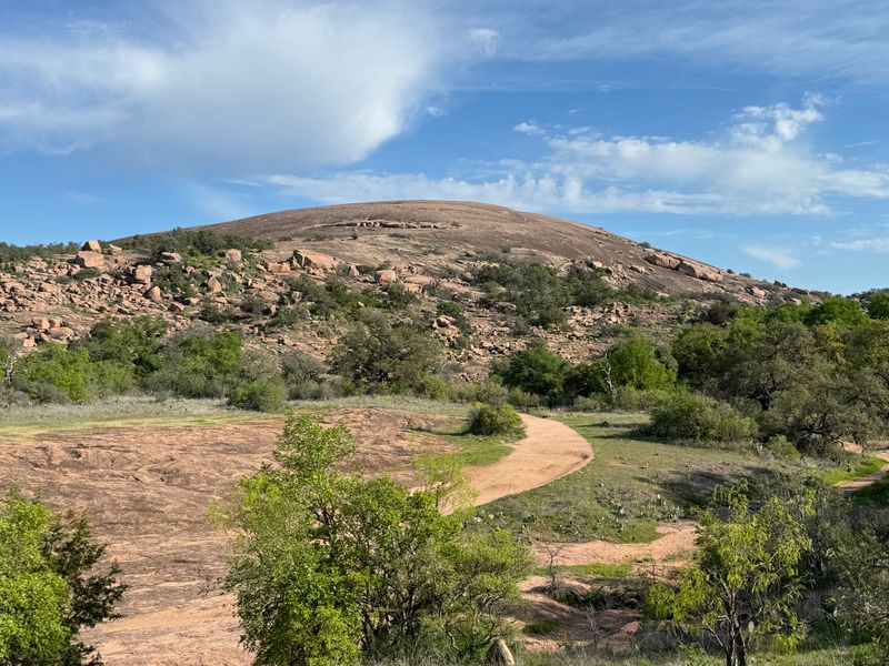
A giant pink granite dome rising 425 feet above the surrounding landscape serves as the anchor for this geological wonder tour.
Begin in Llano, known as the deer capital of Texas, where the courthouse square features local shops and cafes perfect for fueling up.
Drive north on Ranch Road 16 through rolling ranch land dotted with granite boulders that hint at what’s coming.
Enchanted Rock State Natural Area appears suddenly, its massive dome dominating the horizon like an ancient monument.
The rock itself covers 640 acres and formed over a billion years ago deep beneath the earth’s surface.
Tonkawa Indians believed ghost fires flickered on the rock at night, giving it the enchanted name.
Hike to the summit for panoramic views that stretch for miles across the Hill Country, or explore the caves and crevices at the base.
The climb takes about an hour round trip, but go early because the park often reaches capacity on weekends.
After working up an appetite, continue to Mason, a small ranching town famous for its topaz gemstones found in the surrounding hills.
The old jail and courthouse tell stories of frontier justice and cattle rustlers from the late 1800s.
Stop at one of the local diners for chicken fried steak before browsing the rock shops that sell polished topaz specimens.
This route combines natural wonders with small-town charm in a way that captures the essence of the Hill Country experience.
5. Highland Lakes Chain From Marble Falls To Burnet
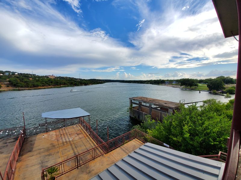
Seven reservoirs strung along the Colorado River create a water wonderland in the eastern Hill Country.
Marble Falls serves as the gateway, where Lake Marble Falls sparkles right in the middle of town.
Walk along the lakeside trail or watch fishermen casting for bass from the shore.
The town’s name comes from the natural marble formations that once created actual falls before the dam flooded them.
Head northwest on Highway 281 toward Burnet, passing between Lake Marble Falls and Lake LBJ.
These connected waterways attract boaters, swimmers, and waterfront diners who enjoy fresh catfish while watching the sun set over the water.
Longhorn Cavern State Park sits just off the route, offering guided tours through a massive cave system used by everyone from Ice Age animals to Confederate soldiers.
The cavern maintains a constant cool temperature, making it a welcome break on hot summer days.
Continue to Burnet, where the restored downtown features murals depicting local history and shops selling everything from cowboy boots to homemade fudge.
Fort Croghan Museum preserves buildings from the frontier military post that protected settlers in the 1800s.
Vanishing Texas River Cruise departs from nearby Canyon of the Eagles, taking passengers through the narrow canyons of Lake Buchanan.
The tour guides point out waterfalls, wildlife, and geological formations while sharing stories about the area’s past.
This drive proves that Hill Country beauty includes more than just rolling terrain and wildflowers.
6. Lost Maples State Natural Area Via Vanderpool
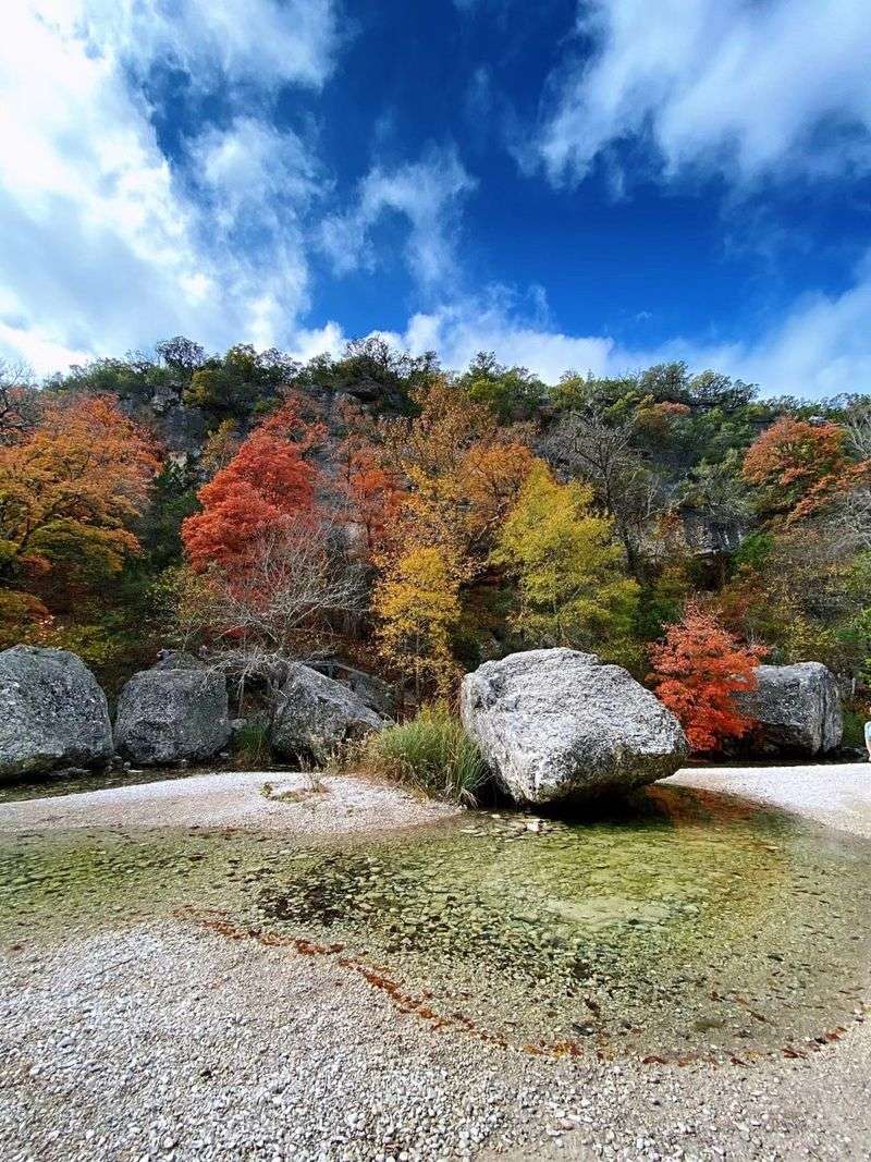
Autumn transforms this remote canyon into a blaze of color rare in Texas.
The drive to Lost Maples State Natural Area takes you deep into the western Hill Country where the landscape becomes more rugged and isolated.
Vanderpool serves as the last outpost before entering the park, with a population barely reaching double digits.
Stop at the Lone Star Motorcycle Museum to see an impressive collection of vintage bikes housed in an unlikely rural location.
The museum’s eclectic collection includes rare models and racing bikes that draw enthusiasts from across the country.
Continue to Lost Maples, where a grove of bigtooth maple trees somehow survived in this protected canyon.
These maples typically grow much farther north, making their presence here a botanical mystery.
Peak color usually arrives in late October or early November when the leaves turn brilliant shades of orange, red, and yellow.
Hiking trails wind through the canyon alongside a spring-fed creek that flows even during drought.
The park limits daily visitors to protect the fragile ecosystem, so arrive early or reserve ahead during fall weekends.
Bird watchers flock here year-round because the diverse habitat attracts species rarely seen elsewhere in Texas.
The drive back through Vanderpool and along the twisting Medina River valley offers constant scenic rewards.
This route requires more driving time than others on this list, but the payoff makes every mile worthwhile.
Pack layers because temperatures in the canyon can be significantly cooler than in surrounding areas.
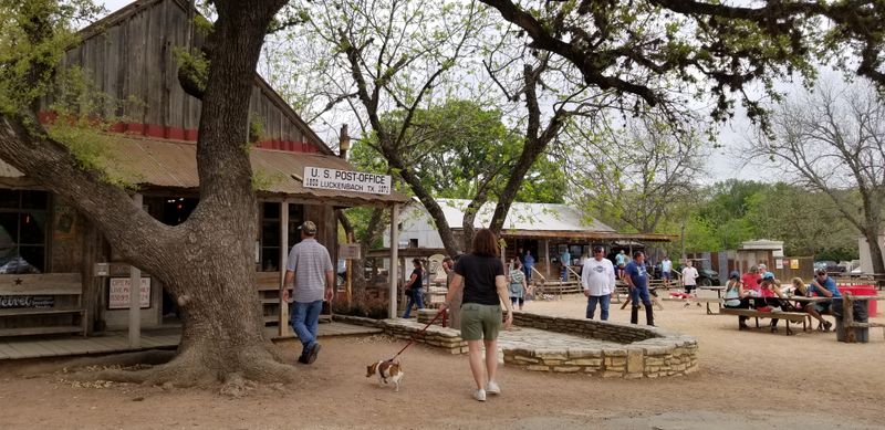
7. Luckenbach To Driftwood Via Dripping Springs
Music legends and local characters have made this backroad route famous in songs and stories.
Luckenbach consists of little more than a dance hall, general store, and a few old oak trees, but the spirit of the place looms much larger.
Willie Nelson and Waylon Jennings immortalized the tiny community in song, and live music still plays under the trees most weekends.
The general store sells cold drinks and souvenirs while locals gather on the porch to swap tales.
No admission fee exists because Luckenbach isn’t really a tourist attraction, just a gathering place that welcomes visitors.
Drive southeast toward Dripping Springs, passing through ranch land where cattle outnumber people by a wide margin.
Dripping Springs calls itself the gateway to the Hill Country, sitting right where the terrain begins its dramatic shift.
Several craft breweries have opened here recently, offering tours and tastings in settings that blend industrial brewing equipment with Hill Country views.
Continue south to Driftwood, home to the Salt Lick BBQ complex that has been smoking meat over open pits since 1967.
The outdoor seating area sprawls across several acres, and the smell of oak smoke greets you a mile before you arrive.
Families share long picnic tables while brisket and ribs disappear by the pound.
This route captures the laid-back Hill Country lifestyle where good music, cold drinks, and slow-smoked meat matter more than hurrying anywhere.
Address: The Salt Lick BBQ, 18300 FM 1826, Driftwood, TX 78619
8. Canyon Lake Circle Through Canyon City And Sattler
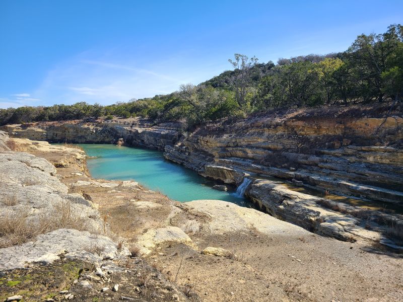
Crystal clear water and limestone cliffs create a miniature paradise just an hour from San Antonio.
Canyon Lake formed in the 1960s when the Army Corps of Engineers dammed the Guadalupe River, creating a reservoir with 80 miles of shoreline.
The drive around the lake follows Farm Road 2673 and connects several small communities that cater to water lovers.
Canyon City offers multiple marinas where you can rent boats, kayaks, or paddleboards to explore the many coves and inlets.
The water stays remarkably clear because limestone filters it naturally, making swimming and snorkeling popular activities.
Overlook Park provides stunning views from high above the lake where you can see the turquoise water contrasting with white limestone bluffs.
Continue around to Sattler, where tube outfitters prepare visitors for floating the Guadalupe River below the dam.
The river section here runs cold and fast, fed by releases from the lake bottom.
Cypress trees line the banks, providing shade and giving the river a different character than the open lake.
Stop at one of the lakeside restaurants for burgers and watch boats come and go from the docks.
The complete loop takes about an hour of driving, but most people stretch it into a full day by stopping to swim, hike, or simply relax by the water.
Weekend traffic can slow things down during summer, but that just gives you more time to appreciate the scenery.
This drive shows how the Hill Country landscape changes when water becomes the main attraction.
Dear Reader: This page may contain affiliate links which may earn a commission if you click through and make a purchase. Our independent journalism is not influenced by any advertiser or commercial initiative unless it is clearly marked as sponsored content. As travel products change, please be sure to reconfirm all details and stay up to date with current events to ensure a safe and successful trip.