Thirty-four miles of trail with no cars, no trucks, and no exhaust fumes. That is the luxury of a good rail-trail, and this Virginia one might be the best in the state.
The old railroad bed has been reclaimed by forest, with a lush canopy overhead that blocks the sun and makes every step feel cooler than it should. I walked a section, passed cyclists gliding downhill and families out for a slow stroll, and barely heard anything except birds and the crunch of gravel under my feet.
The famous bridge over the river is a showstopper, but honestly, the whole thing is beautiful. Flat, shaded, and peaceful.
Perfect for when you want to move without fighting traffic.
A Railroad Reborn: The History Behind the Trail

Long before cyclists clipped in and runners laced up, a slow-chugging steam locomotive was grinding its way through these same Virginia mountains. The railroad earned its colorful nickname “Virginia Creeper” from the almost comically slow pace those old steam engines managed while climbing the steep Appalachian grades.
Originally established in the late 1880s, the line served as a vital link for timber and iron ore industries in the region. For nearly a century, it hauled goods and passengers through some of the most rugged terrain in the state.
By 1977, the railroad had run its last mile and officially ceased operations. Rather than letting the corridor fade into overgrown history, local communities and trail advocates rallied together to transform it into something extraordinary.
The trail officially opened for recreational use in 1987, giving the old rail bed a second life that its original engineers never could have imagined. Today, every wooden trestle and creek crossing you roll or stroll across carries that layered history beneath your feet.
Knowing the backstory makes each step feel like a small tribute to the people who carved this path through Virginia’s wild, beautiful landscape.
The Full 34-Mile Route: Abingdon to Whitetop Explained

Spanning a full 34 miles from Abingdon all the way to Whitetop Station near the North Carolina border, the Virginia Creeper Trail covers an impressive stretch of southwestern Virginia’s most scenic countryside. The trail passes directly through the heart of Damascus, effectively splitting the route into two very different personalities.
The eastern half, running roughly 17 miles from Damascus up to Whitetop, climbs through the Mount Rogers National Recreation Area and rewards you with stunning mountain scenery. This section is the one most famous for its thrilling downhill bike ride, though it sustained serious damage from Hurricane Helene in September 2024 and remains closed for repairs, with an estimated reopening in Fall 2026.
The western half, connecting Abingdon to Damascus across about 15.5 miles, is currently open and in great shape. It rolls through pastoral farmlands, river valleys, and small communities with only a gentle elevation gain that keeps things manageable for nearly everyone.
Knowing the layout before you arrive saves a lot of surprises. Both sections offer their own brand of beauty, and together they paint a vivid picture of why this trail has become one of Virginia’s most celebrated outdoor destinations.
The Abingdon to Damascus Section: Flat, Pastoral, and Perfectly Scenic

If you love the idea of cruising through a living landscape painting without breaking a serious sweat, the Abingdon to Damascus section is your kind of adventure. This 15.5-mile stretch glides through rolling farmlands, open meadows, and quiet river valleys with barely a hill in sight.
The elevation gain here is minimal, less than 300 feet across the whole stretch, which means families, casual riders, and first-time trail users find it incredibly approachable. You’re not grinding uphill or white-knuckling a steep descent.
Instead, you’re pedaling or jogging at a comfortable pace while cows graze in nearby fields and hawks circle lazily overhead.
The trail surface along this section is a well-maintained blend of crushed cinders, packed dirt, and fine gravel. Mountain bikes and hybrid bikes handle it beautifully, and the smooth surface makes it comfortable even for those who aren’t seasoned cyclists.
Starting in the charming town of Abingdon, Virginia, you’ll find free parking, restrooms, and easy trail access right from the trailhead. The town itself has a lovely historic downtown worth exploring before or after your ride.
This section of the Virginia Creeper Trail is open and welcoming visitors right now, making it the perfect current-day escape.
Damascus: The Trail Town That Steals the Show

Smack in the middle of the Virginia Creeper Trail sits Damascus, a tiny mountain town with a personality way bigger than its population. Known affectionately as “Trail Town USA,” Damascus is the beating heart of outdoor recreation in this corner of Virginia, and the energy here is genuinely infectious.
The town sits at the intersection of multiple major trails, including the Appalachian Trail, making it a magnet for outdoor enthusiasts of every stripe. Main Street is lined with outfitter shops, bike rental spots, and laid-back eateries that cater perfectly to trail-weary adventurers who just need a solid meal and a place to sit down.
Bike rental and shuttle services operate right out of Damascus, which is incredibly convenient if you’re planning a one-way downhill ride (once the Whitetop section reopens). Outfitters handle the logistics so you can focus entirely on the experience rather than the car shuffle.
Damascus Town Park serves as a popular trailhead with free parking, restrooms, and water access. Spending even an hour wandering through town between trail legs adds a warm, community feel to the whole trip.
The Virginia Creeper Trail and Damascus are practically inseparable, and honestly, neither one would be quite the same without the other.
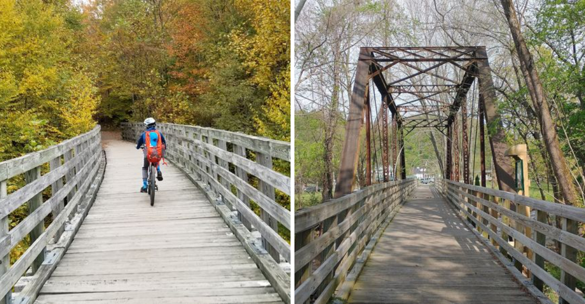
The Trestles: 47 Wooden Bridges That Make Every Mile Memorable

Crossing your first wooden trestle on the Virginia Creeper Trail is a genuine full-stop moment. You roll or walk out onto the creaking planks, look down at a crystal-clear creek tumbling over mossy rocks below, and suddenly understand why people keep coming back to this trail year after year.
There are roughly 47 to 50 of these trestles and bridges scattered across the trail’s full length, each one a beautifully preserved piece of the original railroad infrastructure. Some span modest little streams, while others carry you high above wide creek valleys that open up into breathtaking views.
The trestles along the Whitetop Laurel Creek corridor are particularly spectacular, with the water running cold and clear below. That stretch is unfortunately part of the section currently closed for hurricane damage repairs, but the Abingdon to Damascus section still offers its own share of charming bridge crossings over the South Fork of the Holston River.
Photographers absolutely love these structures, and it’s easy to see why. The contrast of weathered timber against bright green forest creates a composition that practically frames itself.
Pausing mid-trestle for a moment of quiet appreciation is not just allowed, it’s practically mandatory on the Virginia Creeper Trail.
Wildlife Along the Trail: More Than Just Deer and Squirrels

The Virginia Creeper Trail isn’t just a path through the woods. It’s a living, breathing wildlife corridor that rewards patient observers with sightings that make the whole outing feel unexpectedly wild.
Deer are a common sight, especially in the early morning and late afternoon when they drift out of the tree line to graze near the trail edges. Raccoons, squirrels, and wild turkeys make frequent appearances too, often completely unbothered by passing cyclists or joggers.
Birdwatchers have a genuine field day along this corridor. The diverse habitats, ranging from dense forest to open farmland to streamside vegetation, attract a wide variety of species throughout the seasons.
Spring migration in particular turns the trail into an impromptu birding paradise.
Whitetop Laurel Creek, once the section reopens, is especially notable as a designated wild trout stream. Fly fishers wade its banks with serious intent, and the crystal-clear water is a strong indicator of just how pristine this ecosystem remains.
Sharing the path with so much wildlife adds a spontaneous, almost unpredictable quality to every outing. You never quite know what’s going to emerge from the tree line next, and that sense of pleasant surprise is one of the Virginia Creeper Trail’s quietest but most enduring charms.
Biking the Trail: Everything You Need to Know Before You Ride

Cycling the Virginia Creeper Trail is the kind of experience that turns casual riders into passionate trail advocates. The surface, a firm blend of crushed cinders, packed dirt, and fine gravel, handles mountain bikes and hybrid bikes with ease.
Road bikes, however, are better left at home.
The Abingdon to Damascus section currently open runs a comfortable 15.5 miles with minimal elevation change, making it ideal for families, beginners, and anyone who’d rather enjoy the scenery than count calories burned. The pace here is relaxed and communal, with plenty of spots to pull over and soak in a view.
Bike rentals are available from outfitters based in both Damascus and Abingdon, so you don’t necessarily need to haul your own gear. Many outfitters also offer shuttle services, allowing you to ride one way and skip the return trip entirely.
Helmets are strongly recommended, and trail etiquette matters here. Yield to hikers and equestrians, call out when passing, and keep your speed considerate on shared sections.
The Virginia Creeper Trail thrives because people treat it with respect.
Once the Whitetop to Damascus section reopens in Fall 2026, the famous 17-mile downhill run will be back on the menu, and that’s genuinely something worth planning ahead for.
Walking and Running the Trail: A Traffic-Free Path Through Pure Nature

Not every great trail experience requires a bicycle. The Virginia Creeper Trail is equally magnificent on foot, and runners and hikers have been quietly claiming it as their own for years.
The smooth, firm surface makes for comfortable running without the jarring impact of pavement. Long-distance runners particularly appreciate the flat-to-gentle grades of the Abingdon to Damascus section, which allows for steady, rhythmic miles without the constant elevation demands of mountain trail running.
Hikers move at a different pace and often get the richer sensory experience for it. Walking slowly enough to notice the way morning mist hangs over the South Fork of the Holston River, or to catch the sound of woodpeckers working the tree trunks above, is a genuinely restorative experience.
The trail is wide enough to comfortably accommodate foot traffic alongside cyclists and equestrians without feeling crowded. Early mornings on weekdays offer especially peaceful conditions, when the forest feels like it belongs entirely to you.
Virginia has no shortage of beautiful outdoor spaces, but the car-free, traffic-free nature of this rail-trail creates a specific kind of calm that’s hard to replicate. Every footfall lands on history, and every mile reveals something new worth noticing on the Virginia Creeper Trail.
Trail Access Points, Parking, and Practical Visitor Info

Getting onto the Virginia Creeper Trail is refreshingly straightforward, with multiple well-marked access points spread across the route. Free public parking is available at the main trailheads in Abingdon, Alvarado, and Damascus Town Park, which is genuinely appreciated in an era when trail fees seem to pop up everywhere.
The Abingdon trailhead is particularly well-equipped, featuring restrooms, informational signage, and easy road access right from the town center. It serves as the western anchor of the trail and is a natural starting point for the currently open Abingdon to Damascus section.
Damascus Town Park offers similar amenities in the middle of the route, including restrooms and water access. It’s a popular mid-point stop for those doing the full western section out and back, or a convenient trailhead for those who want to explore just a portion of the trail.
Cell service can be spotty in the more remote forested sections, so downloading an offline trail map before heading out is a smart move. The Virginia Creeper Trail Conservancy maintains an up-to-date website with current trail conditions and closure information, which is especially important given the ongoing Whitetop to Damascus repairs.
The trail address for navigation purposes is along Virginia’s Route 58 corridor in Washington and Grayson Counties, Virginia.
Plan Your Visit: Seasons, Tips, and Why You Should Go Now

Every season brings a completely different mood to the Virginia Creeper Trail, and honestly, arguing about which is best is a perfectly valid way to spend an afternoon. Fall foliage season turns the entire corridor into a tunnel of gold, orange, and red that is almost aggressively beautiful.
Spring brings wildflowers popping up along the trail edges and the creeks running full and fast with snowmelt. Summer is peak season, with long daylight hours and the forest canopy providing welcome shade on warm afternoons.
Winter visits, while quieter, offer a stripped-back view of the landscape that reveals the trail’s underlying structure and geology in surprising ways.
Weekday visits in the shoulder seasons, particularly May and October, offer the best combination of great conditions and manageable crowds. Weekends in summer can get busy, especially near Damascus and Abingdon.
Layering is smart regardless of season, as the forested sections stay noticeably cooler than surrounding areas. Bringing more water than you think you need is always a good call on any trail this long.
The Virginia Creeper Trail is located in southwestern Virginia, with the main trailhead in Abingdon at 411 Pecan Street, Abingdon, VA 24210. Go soon, go often, and tell everyone you know.
Dear Reader: This page may contain affiliate links which may earn a commission if you click through and make a purchase. Our independent journalism is not influenced by any advertiser or commercial initiative unless it is clearly marked as sponsored content. As travel products change, please be sure to reconfirm all details and stay up to date with current events to ensure a safe and successful trip.