Plenty of travelers pass through southwest Virginia, admire the mountains for a moment, and move on without realizing what they’re missing. Hidden in plain sight is a trail so quietly impressive that even seasoned hikers often overlook it.
I found it by accident, and it completely reshaped how I see Virginia’s high country. The climb, the summit, and the views feel like a well-kept secret rather than a crowded destination.
What follows is everything that makes this trail stand out and what to know before setting foot on it.
The Mount Rogers Trail: Virginia’s Best-Kept Secret Path
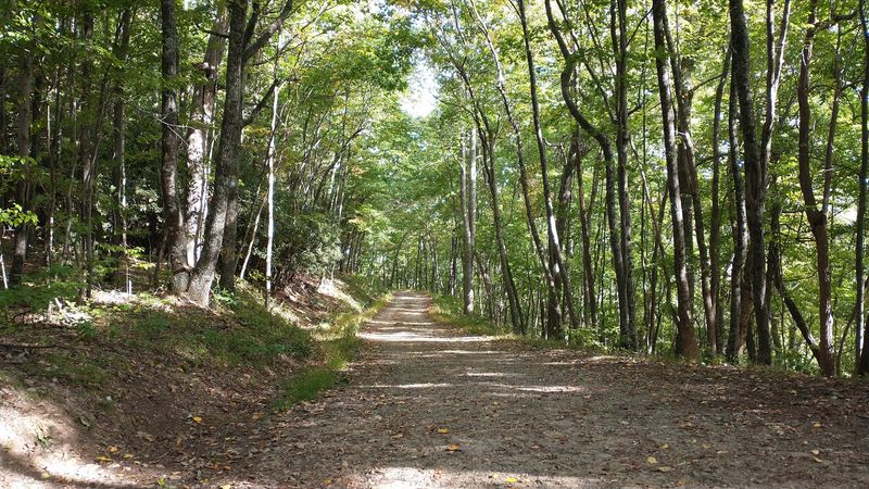
Forget the crowded shortcuts. The Mount Rogers Trail is a 12.5-mile out-and-back route that starts quietly at Road 603, slips into the Lewis Fork Wilderness, and rewards every step with scenery that feels genuinely untouched.
Most hikers heading to Virginia’s highest summit never even notice this trailhead. They roll straight toward Grayson Highlands State Park, hop on the Appalachian Trail, and call it a day.
Totally valid, but they miss something special.
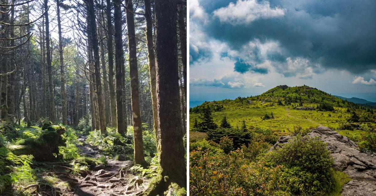
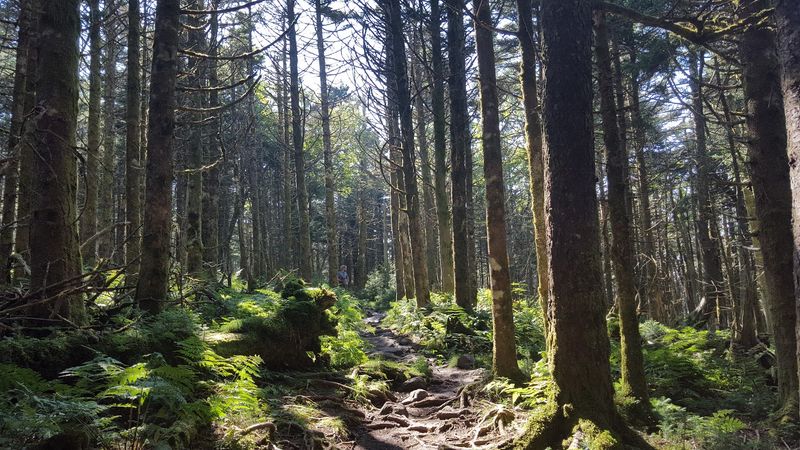
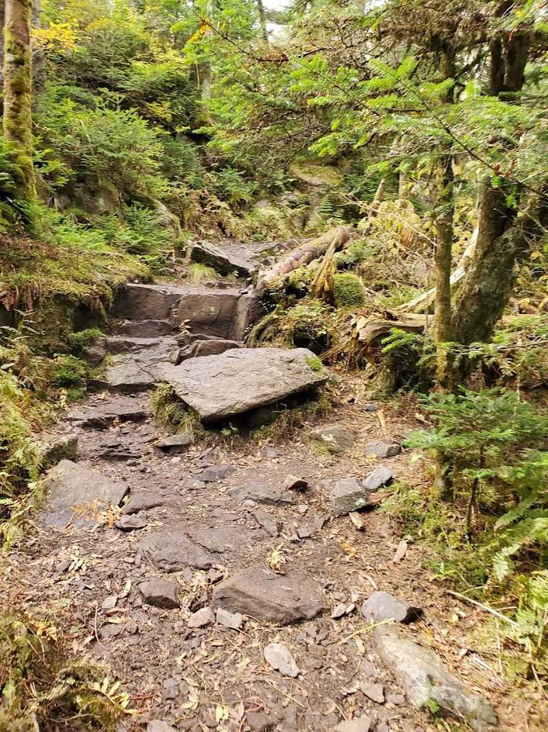
This path cuts through rocky terrain, dense vegetation, and patches of old-growth forest that feel almost prehistoric. Navigation gets tricky in spots, especially where sections grow overgrown or downed trees block the way.
That mild challenge is precisely what keeps the crowds away.
The payoff comes when the trail intersects with the Appalachian Trail. Turn left, then left again onto the Mount Rogers Spur Trail, and the summit is yours.
The elevation gain pushes past 2,400 feet total, so solid footwear matters.
Pack trekking poles, load up on water, and give yourself a full day. Solitude this complete is rare anywhere in Virginia, let alone at the state’s highest point.
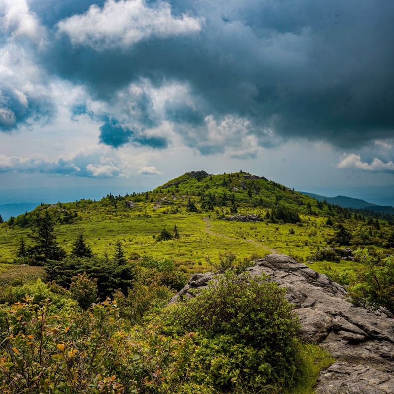
Standing on Top of Virginia: What the Summit Actually Looks Like
Surprise, the summit does not look like a dramatic rocky pinnacle. At 5,729 feet, Mount Rogers is completely wrapped in a thick blanket of Fraser fir and red spruce, giving it more of a mystical forest cathedral vibe than a sweeping overlook.
No panoramic views wait at the top. What you get instead is something quieter and honestly more interesting: a sense of standing inside a living, breathing high-elevation ecosystem found almost nowhere else in Virginia.
The air up there carries a sharp, resinous scent from the conifers. Mosses carpet every boulder.
Birdsong echoes differently at this altitude, and the wind moves through the trees with a particular kind of hush that city life never offers.
A small summit marker identifies the spot, making it a satisfying destination even without a dramatic viewpoint. Many hikers later say the forested top surprised them in the best possible way.
Virginia’s highest point is a reminder that natural beauty does not always announce itself loudly. Sometimes it whispers, and you have to slow down long enough to actually hear it.
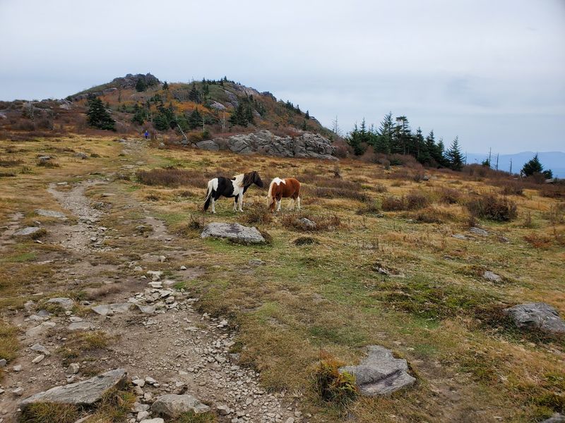
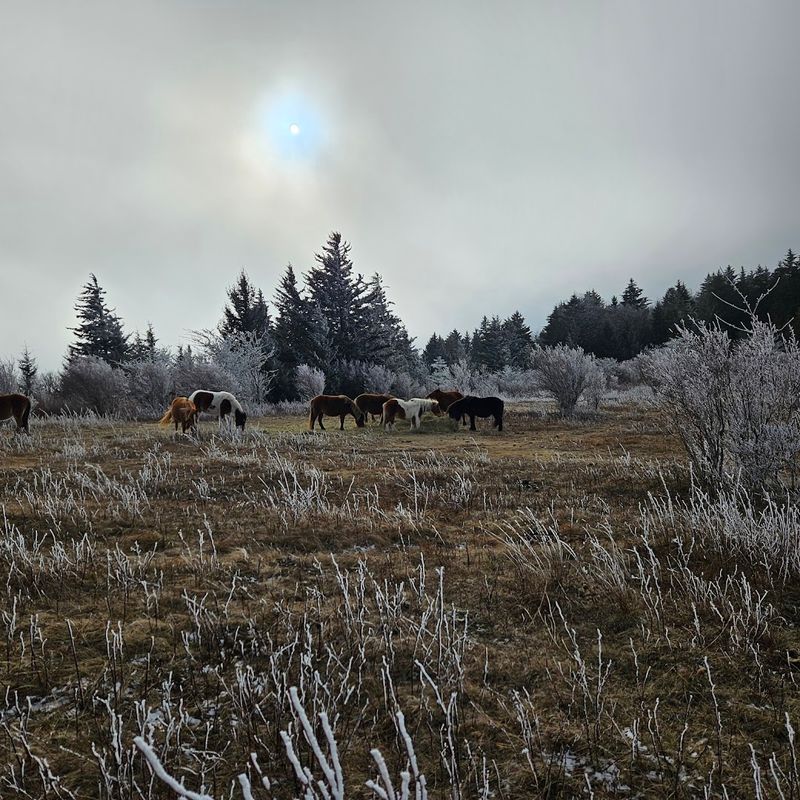
Wild Ponies and Open Meadows: The Grayson Highlands Magic
Few hiking experiences in the entire eastern United States match the surreal joy of rounding a bend on Wilburn Ridge and coming face-to-face with a wild pony casually ignoring your existence.
Grayson Highlands State Park serves as the most popular gateway toward Mount Rogers, and the wild pony herd living on its open balds is a massive part of the draw. These free-roaming ponies have called this high plateau home for decades, grazing across the rocky meadows like they own the place.
They basically do.
The open balds themselves are stunning even without the ponies. Grassy expanses stretch across the ridge tops, framed by distant blue mountains and enormous granite outcroppings that kids love to scramble across.
Starting a Mount Rogers hike from Massie Gap inside Grayson Highlands puts you on a well-marked Appalachian Trail route with consistent white blazes guiding the way. The final stretch to the summit switches to blue blazes, signaling the spur trail.
Virginia’s high country does not get more photogenic than this. Bring a camera, obviously, but also bring patience because those ponies move on their own schedule.
The Appalachian Trail Connection That Changes Everything
The Appalachian Trail runs right through this corner of Virginia, and that intersection transforms a Mount Rogers hike into something much bigger than a simple summit bag.
Southbound from Grayson Highlands, the AT rolls across some of the most scenic high-country terrain in the entire southern Appalachians. Open ridges, rocky outcroppings, and sweeping valley views appear in rapid succession, making the roughly 3.5-mile approach feel far shorter than the numbers suggest.
Thru-hikers passing through this section consistently rank it among the most beautiful stretches of the entire 2,000-plus-mile trail. That reputation is well-earned.
The combination of grassy balds, forest passages, and mountain panoramas packs an enormous amount of variety into a relatively short distance.
For day hikers, the AT approach from Grayson Highlands provides a more straightforward and clearly marked route compared to the Mount Rogers Trail. White blazes guide every step, and the trail itself stays in good condition year-round.
Linking the AT approach with a return via Wilburn Ridge creates a satisfying loop that covers the best scenery the area offers. Virginia hiking does not get much better than this particular combination of trail segments.
Lewis Fork Wilderness: The Wild Heart of the Hike
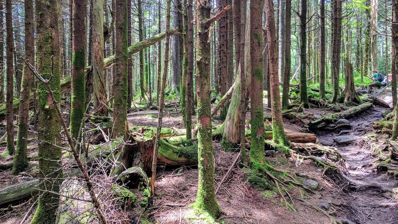
Most people have never heard of Lewis Fork Wilderness, and that is exactly why it deserves its own spotlight. Designated wilderness status means no motorized equipment, no mountain bikes, and no shortcuts, just raw forest the way it has always been.
The Mount Rogers Trail passes directly through this protected area, and the atmosphere shifts noticeably once you cross into it. Trees grow older and larger.
The understory thickens. The trail narrows and the outside world disappears completely.
Rocky sections keep you paying attention to your footing, which is actually a good thing. Mindful hiking slows the pace just enough to notice details: a patch of rare high-elevation wildflowers, a stream tumbling over mossy rocks, the sudden flash of a wood thrush darting between branches.
Downed trees occasionally block the path, remnants of storms that no crew has cleared because that is how wilderness management works. Scrambling over or around them adds a small adventure element that feels earned rather than manufactured.
Lewis Fork Wilderness represents what Virginia’s mountain landscape looked like before roads arrived. Spending a few hours inside it recalibrates your sense of scale and reminds you how genuinely vast and wild this region remains.
Mount Rogers National Recreation Area: More Than Just a Summit
The summit gets the headlines, but Mount Rogers National Recreation Area spans roughly 154,000 acres of George Washington and Jefferson National Forests. That is a lot of mountain to explore beyond a single peak.
Horse trails crisscross the area alongside hiking routes, making it one of the more equestrian-friendly recreation areas in Virginia. Riders travel through the same spectacular highland scenery that hikers enjoy, just at a slightly different pace and elevation perspective.
Campgrounds dot the landscape, including the Hurricane Campground tucked off the main roads along winding one-lane gravel routes that feel like a proper backcountry adventure even before you pitch a tent. The remoteness is part of the charm.
Fishing opportunities exist throughout the area, with streams running cold and clear through forested hollows. Wildlife sightings are common, including black bear, white-tailed deer, and a remarkable diversity of bird species that makes this corner of Virginia a genuine draw for naturalists.
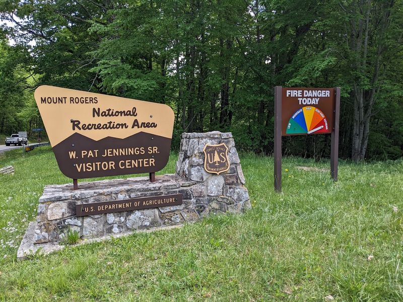
The welcome center near the main entrance provides trail maps, current conditions, and genuinely helpful staff who know every corner of the area. Stopping there before heading out saves time and prevents the kind of navigational confusion that turns good hikes into stressful ones.
The Mount Rogers Loop: Nine Miles of Serious Highland Drama
Nine miles sounds manageable until the trail starts climbing and the scenery starts competing for your attention. The Mount Rogers Loop via the Appalachian Trail is a certified classic for experienced hikers who want variety packed into a single day outing.
Covering roughly 9.4 miles with over 1,200 feet of elevation gain, this loop threads together open balds, forested ridges, rocky scrambles, and quiet woodland passages in a sequence that feels almost choreographed for maximum impact.
Starting and finishing at the same trailhead, the loop format means no backtracking, no retracing steps through scenery you already saw. Each mile reveals something genuinely new, which keeps energy and motivation high even when legs start to tire.
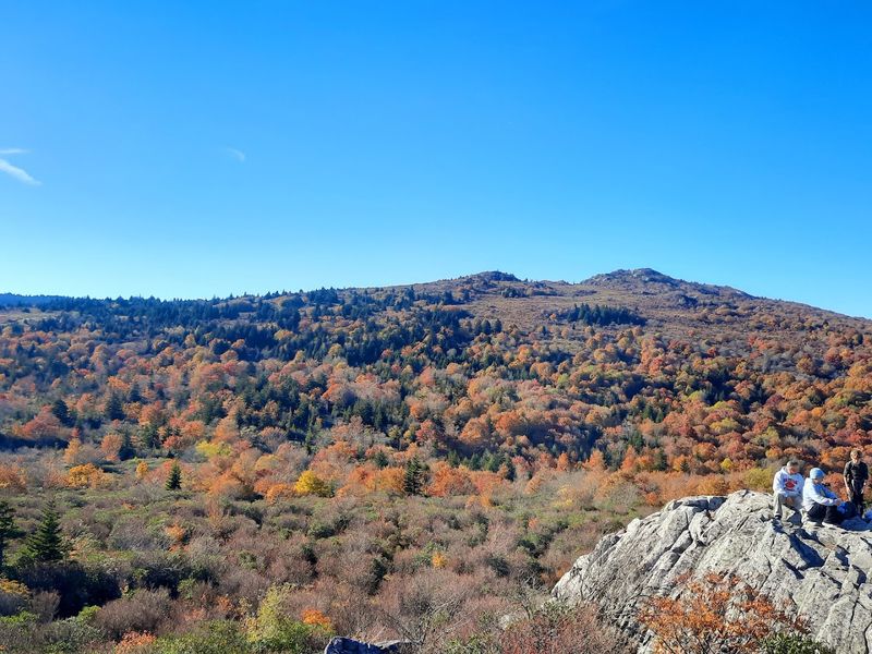
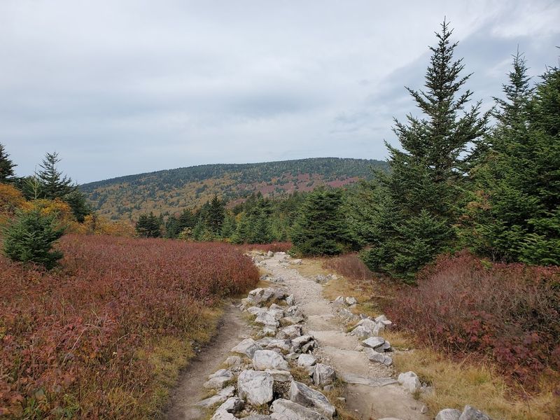
Fall transforms this loop into something almost otherworldly. Hardwood trees ignite in amber and crimson below the evergreen conifer zones near the summit, creating a layered color display that stops hikers cold in the middle of the trail just to stare.
Spring brings a different reward: wildflowers carpeting the balds and forest floor, migratory birds filling every tree, and waterfalls running at full volume after snowmelt. Virginia’s high country cycles through seasons with remarkable theatrical flair.
Seasonal Magic: When to Visit for Peak Experiences
Timing a Mount Rogers visit correctly makes an enormous difference in what you experience. Each season brings its own personality to this high-country landscape, and none of them disappoint if you know what to expect.
Summer offers the mildest temperatures on the summit, often running a full ten degrees cooler than the valleys below. Afternoons can bring quick thunderstorms, so morning starts are strongly recommended.
Wild berries ripen along the trail edges in August, a bonus snack for attentive hikers.
Autumn delivers the most visually dramatic conditions, with foliage peaking across the slopes and ridges in a rolling wave of color that moves from the summit downward as October progresses. Crowds increase during peak fall weekends, so midweek visits offer a calmer experience.
Winter turns the spruce-fir forest near the summit into a genuine ice-and-snow wonderland. Ice formations cling to the trees and rocks, and the silence at elevation in January feels almost sacred.
Proper cold-weather gear is non-negotiable.
Spring arrives late at this altitude, with wildflowers and fresh green growth emerging weeks after the valleys have already warmed up. Catching that late-spring bloom on the high balds is one of Virginia’s truly underrated seasonal pleasures.
Gear Up Right: What the Trail Actually Demands
The Mount Rogers Trail earns its challenging rating honestly. Rocky footing, overgrown sections, and significant elevation gain mean this is not a casual sneakers-and-a-water-bottle situation.
Preparation makes the difference between a great day and a miserable one.
Sturdy ankle-supporting trail boots are the single most important piece of equipment for this hike. The rocky terrain on the Mount Rogers Trail specifically puts real stress on ankles, and a rolled joint miles from the trailhead is nobody’s idea of fun.
Trekking poles earn their weight on both the ascent and descent. The downhill stretch back from the summit covers significant rocky ground, and poles provide stability that tired legs genuinely appreciate after several hours of hiking.
Navigation tools matter here more than on the AT approach. The Mount Rogers Trail sees less traffic, meaning trail markers are less frequent and some sections require closer attention to stay on route.
A downloaded offline map or a printed topo adds real peace of mind.
Layering is essential regardless of season. Summit temperatures drop quickly, afternoon weather changes fast, and the dense forest near the top holds moisture that can chill you even on warm days.
Pack a light insulating layer and a rain shell every single time.
Finding Your Way: Directions, Address, and Final Tips
Getting to this corner of Virginia requires a bit of intentionality, but the drive itself is part of the reward. Southwest Virginia’s back roads wind through small towns, farmland, and forested hollows that set the mood long before the trailhead appears.
The Mount Rogers National Recreation Area welcome center sits at 3714 VA-16, Marion, VA 24354. Stopping there first is always a smart move.
Staff provide current trail conditions, updated maps, and advice specific to what you are planning to hike that day.
For the Grayson Highlands approach to the summit, head to Grayson Highlands State Park near Mouth of Wilson, Virginia. The Massie Gap parking area serves as the standard starting point for AT-based summit attempts.
Arrive early on weekends to secure a spot.
The Mount Rogers Trail trailhead at Road 603 requires a bit more navigation to locate, which is part of why it stays quieter. A GPS device or navigation app with the trailhead coordinates loaded in advance saves considerable frustration on arrival.
Cell service is limited throughout much of the recreation area, so download maps and confirm plans before leaving town. Virginia’s high country rewards preparation generously and punishes overconfidence with equal enthusiasm.
Go ready, and it gives back everything.
Dear Reader: This page may contain affiliate links which may earn a commission if you click through and make a purchase. Our independent journalism is not influenced by any advertiser or commercial initiative unless it is clearly marked as sponsored content. As travel products change, please be sure to reconfirm all details and stay up to date with current events to ensure a safe and successful trip.