You want an Oregon road trip that feels like three adventures in one, and this route delivers it with mountains, forests, and beaches in one continuous flow.
Each stop layers new scenery and culture without losing momentum, so you keep discovering while staying on schedule.
Expect coastal drama, river carved canyons, and volcanic plateaus that feel worlds apart yet sit within a single state.
Pack layers, charge your camera, and let Oregon surprise you at every bend.
1. Pacific Coast Scenic Byway, Highway 101
Oregon’s terrain weaves together seaside cliffs, evergreen forests, and rugged mountains, and the Pacific Coast Scenic Byway threads these scenes into one coastal ribbon.
Along a single road trip, travelers can witness this diversity firsthand, moving from the Pacific’s edge through the state’s woodlands and up to the peaks of the Cascade Range.
This itinerary links coastal wonders, dense forests, and volcanic landscapes, allowing for a varied mix of recreation and cultural experiences in a single journey.
The following guide lays out a thoughtfully sequenced route, with each stop selected for its distinctive character, accessibility, and what it contributes to the overall experience.
Each section includes key features, travel details, and honest insights to help you plan your route effectively and travel with confidence across Oregon.
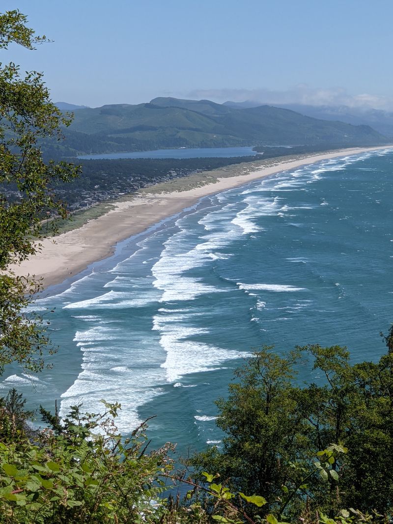
A timeless sense of movement defines the Pacific Coast Scenic Byway, especially as Highway 101 bends beside surf and headlands.
Travelers often recall their first glimpse of the coastline, rugged headlands, foaming surf, and the characteristic sweep of Highway 101 hugging the land’s edge.
Each curve of the road reveals new perspectives, from sandy beaches to forested bluffs that rise suddenly above the Pacific and then settle into tidewashed coves.
Stops like Cannon Beach and Oswald West State Park punctuate the drive, offering both iconic landmarks and quieter stretches for reflection.
Haystack Rock is a familiar silhouette, while Ecola State Park draws visitors with trails threading through spruce forests to ocean vistas in every direction.
Wildlife enthusiasts can spot seabirds, harbor seals, and migrating whales from signed pullouts with safe parking.
Small towns along the route provide chances to refuel and explore local art or sample seafood in casual, welcoming spaces.
Despite being a popular drive, the Byway maintains pockets of solitude, especially outside peak travel months and on weekday mornings.
Look for maintained overlooks with railings and restrooms, which make photo stops simple and quick.
Address, Highway 101, from Astoria OR to Brookings OR.
2. Columbia River Gorge Scenic Byway
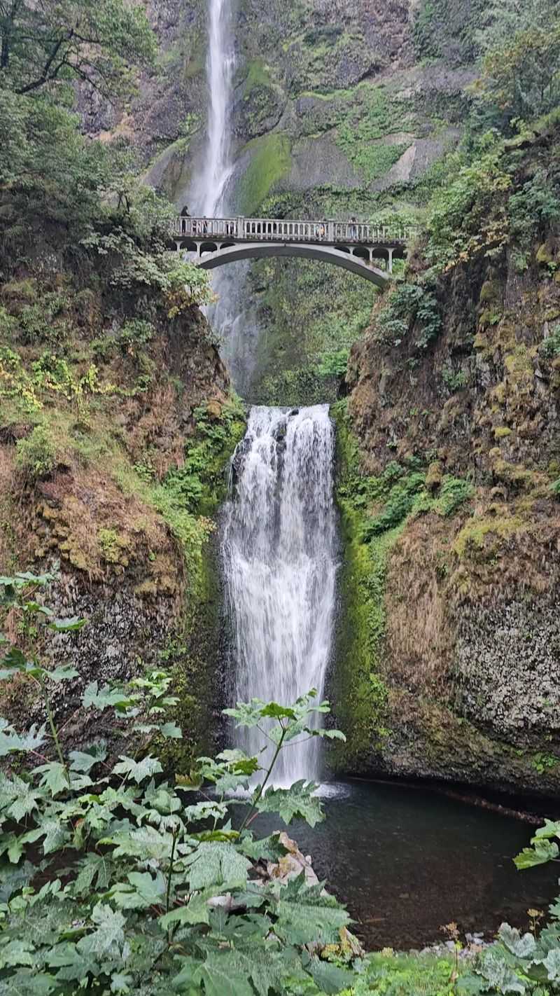
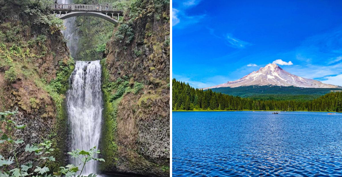
Few drives in the Pacific Northwest match the drama of the Columbia River Gorge Scenic Byway, where cliffs and waterfalls define the horizon.
The landscape shifts quickly, one moment revealing steep basalt cliffs, the next a curtain of waterfalls tumbling into mossy glens near the Historic Highway.
Multnomah Falls stands out with its double plunge, yet many smaller cascades line the corridor for short, satisfying stops.
The Vista House at Crown Point offers panoramic views that glow at sunrise and soften in late afternoon light.
Interpretive signs along turnouts explain both the geology and the story of human settlement that shaped Oregon’s river gateway.
Hiking options range from quick waterfall walks to longer routes like the Eagle Creek Trail when conditions allow.
Spring paints the slopes with wildflowers, and autumn layers the canyon in color, with wind sometimes sweeping through.
Bring layers for variable weather, and shoes with grip for damp stone near bridges and spray zones.
Parking fills early at popular sites, so plan alternate viewpoints on the Historic Columbia River Highway State Trail.
Day use areas include restrooms and signed safety railings, making photo breaks efficient and safe.
Historic tunnels, masonry walls, and pullouts showcase early highway engineering and thoughtful design.
Water levels and trail access can change after storms, so check current conditions before committing to longer hikes.
Nearby small towns offer galleries and relaxed storefronts where you can browse between scenic stops.
The route pairs well with a later push toward Mount Hood for a mountain capstone to your Oregon loop.
Address, Vista House at Crown Point, 40700 Historic Columbia River Hwy, Corbett OR 97019.
3. Cascade Lakes Scenic Byway
For high country calm, the Cascade Lakes Scenic Byway strings together reflective waters and lodgepole forest south and west of Bend.
This route passes Sparks, Elk, and Lava Lakes, each with distinct shorelines and backdrops shaped by Oregon’s volcanic story.
Early mornings can bring still water and mist, while afternoons reveal textured pumice fields and long mountain views.
Mount Bachelor anchors the skyline, and trailheads branch toward meadows, cinder cones, and fire lookout hills.
In summer, hiking and mountain biking fill the daylight, and winter closes segments as snow builds across the passes.
Boat launches, picnic tables, and signed viewpoints make access straightforward for quick pauses or longer stays.
Interpretive stops outline lava flows and calderas that form the high plateau, making the drive feel like a rolling geology lesson.
Cell service can be patchy, so download maps before leaving Bend or Sunriver.
Road shoulders are narrow in places, and pull into designated turnouts for photos to keep traffic moving.
Trail etiquette is appreciated, since these paths see steady use during the peak season in Oregon.
Keep an eye on weather, which can shift rapidly with altitude and afternoon convection.
Dawn and dusk bring calmer wind on the bigger lakes, good for quiet shoreline walks.
Restrooms and trash facilities sit at signed recreation sites, helping protect the sensitive watershed.
The circuit feels like a natural bridge between desert rimrock and the snowy heart of the Cascades.
Address, Cascade Lakes National Scenic Byway, Bend OR 97702.
4. Three Sisters Wilderness
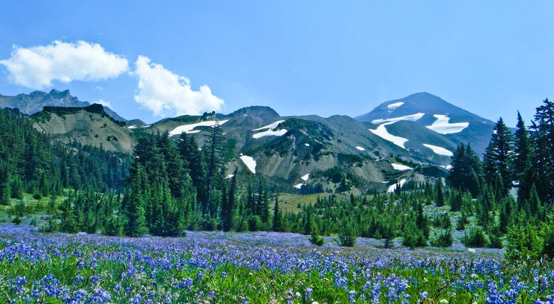
Adventure seekers look to the Three Sisters Wilderness for volcanic summits and quiet meadows within easy reach of central Oregon towns.
North, Middle, and South Sister rise over forests that hold lakes, creeks, and pumice flats shaped by ancient eruptions.
The Green Lakes Trail moves beside creeks toward clear basins where peaks mirror in calm water.
Climbers head for South Sister when conditions allow, choosing early starts for firm footing and clear horizons.
Permits are required at select trailheads during peak season to protect fragile soils and vegetation.
Wildlife sightings include deer, pika, and high elevation birds that thrive in subalpine terrain.
Carry navigation, water treatment, and layers, since storms can rise quickly above treeline in Oregon.
Footing ranges from soft dust to sharp lava, so sturdy shoes matter on long switchbacks.
Camps sit in designated zones where solitude and starry skies reward patient planners.
Leave no trace practices help keep popular basins healthy for future travelers and local species.
Creek crossings can vary with snowmelt, and late season brings cooler nights that sharpen the air.
Trail junctions are signed, yet a map or downloaded guide helps confirm distances and direction.
Wildflower displays peak mid season, followed by golden grasses that sway under the peaks.
This wilderness adds a deep mountain chapter to any Oregon road trip that begins on the coast.
Address, Green Lakes Trailhead, Cascade Lakes Hwy, Bend OR 97703.
5. Mount Hood National Forest
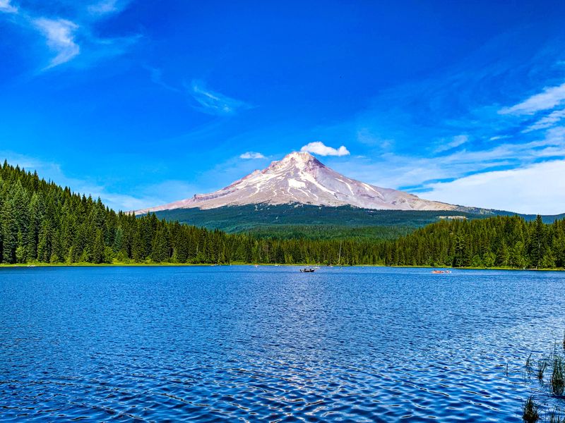
Mount Hood National Forest blends recreation with history around Oregon’s tallest peak and an easy to access lake circuit.
Many visitors begin at Trillium Lake, where a level path circles water that often reflects the mountain in calm weather.
Anglers and photographers share the shore, and day use areas include clear signage and established parking.
Timberline Lodge sits high on the south side, a functioning base with stone, wood, and wide mountain views.
Guests can tour public areas, step onto signed trails, and learn about craftsmanship that shaped this landmark.
Lower down, Tamanawas Falls rewards a moderate hike with a broad curtain of water and basalt alcoves.
Trail surfaces range from packed dirt to rock, so sturdy footwear pays off in wet conditions.
Seasonal changes bring wildflowers, berries, and snow that transforms meadows into quiet winter scenes.
Road conditions can shift with storms, and chains may be required during colder months.
Restrooms, picnic tables, and viewpoint pullouts keep the loop comfortable for a mixed group.
The forest forms a natural connector between the Columbia River Gorge and central Oregon plateaus.
Ranger stations offer maps and current advisories that help fine tune a flexible plan.
Sunrise and late day light flatter the mountain, making short walks feel memorable and unhurried.
This stop adds a classic alpine profile to an Oregon itinerary that started with sea spray.
Address, Trillium Lake Day Use, NF Road 2656, Government Camp OR 97028.
6. Oregon Dunes National Recreation Area
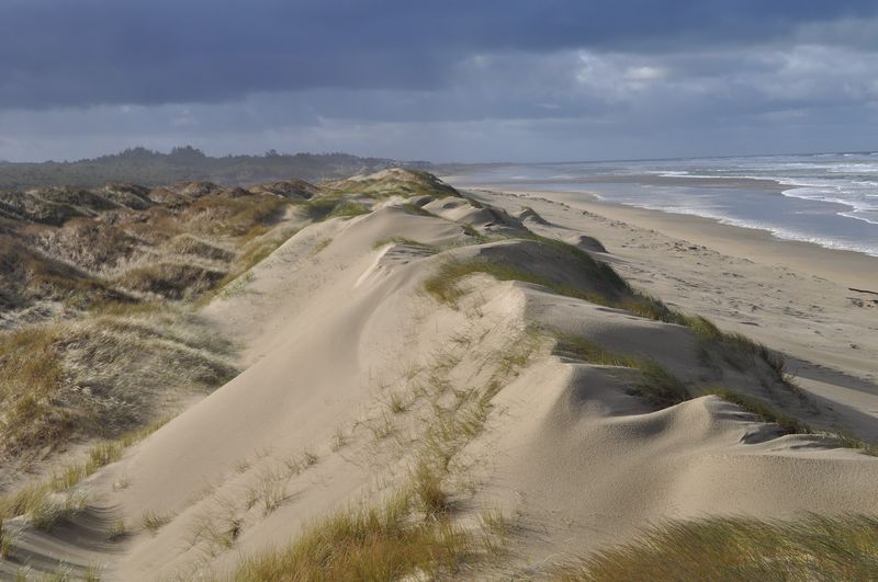
The Oregon Dunes National Recreation Area surprises first time visitors with tall dunes that roll beside coastal forest and inlets.
Wind sculpted ridges change daily, and light shifts carve shadows that feel cinematic from roadside viewpoints.
Designated areas host motorized routes, while quieter zones favor hikers who want solitude and soft horizons.
Boardwalks cross fragile vegetation where grasses hold sand in place against winter storms.
Interpretive signs explain rare plant communities and the species that adapt to shifting ground.
Fog can lend a dreamlike tone in the morning, then lift to bright contrast by midday.
Choose marked trailheads and climb gently to crests that overlook estuaries and the Pacific.
Shoes fill with sand quickly, so gaiters or taller socks can make walking more comfortable.
Carry water and sun protection, since wind can mask heat even on mild Oregon days.
Wayfinding improves with visible landmarks such as tree islands and signed posts near access points.
Wildlife tracks reveal unseen movement, and low tide expands beach walking beyond dune bowls.
Nearby towns supply lodging and simple services without pulling you far from the sand.
This landscape offers a complete contrast to the forests and peaks elsewhere on the route.
Time your arrival to avoid weekend congestion if you prefer quiet views and empty crests.
Address, Oregon Dunes Visitor Center, 855 US 101, Reedsport OR 97467.
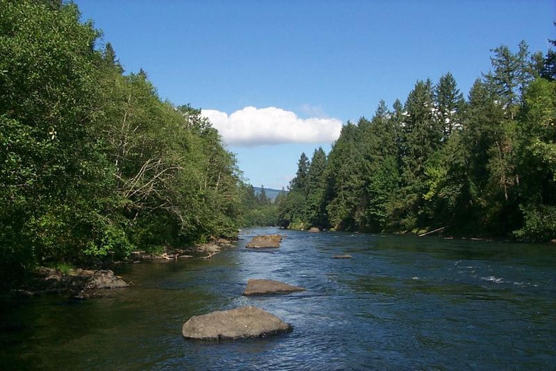
7. Eugene and McKenzie River Corridor
Eugene anchors the southern Willamette Valley with parks, paths, and easy movement from city blocks to riverside green.
Downtown galleries and markets sit near bike bridges that link neighborhoods to tree lined paths.
The Willamette and McKenzie Rivers support kayaking, fishing, and cycling with frequent river access points.
Heading east, the McKenzie River Scenic Byway reveals clear water, basalt ledges, and short trails to falls.
Sahalie and Koosah Falls share a loop with viewpoints that feel close enough to touch spray.
Hot springs and old growth stands appear in side valleys that remain shaded on bright days.
Trail surfaces range from paved paths to packed dirt with roots and occasional rock steps.
Seasonal color peaks in autumn, and spring greens return early along sheltered bends.
Local trail maps help pick gentle gradients for families or longer routes for steady walkers.
Restaurants and cafes cluster near the riverfront, making breaks easy after a morning ride.
Wayfinding signs keep navigation simple, and parking lots are well placed at major parks.
This corridor rounds out an Oregon itinerary with culture, nature, and a slower pace.
It also serves as a gateway toward the Cascades for travelers continuing east.
Expect cool mornings near the water, followed by warm afternoons that invite more exploring.
Address, Eugene Riverfront Park, 500 Ferry St, Eugene OR 97401.
8. Astoria at the Columbia River Mouth
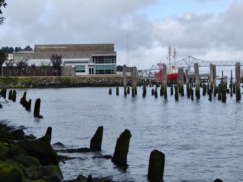
Astoria sits where the Columbia River meets the Pacific, a harbor town with layered history and steep streets.
Its hillside neighborhoods climb toward the Astoria Column, which carries murals that tell a regional story.
From the top, river and ocean views stretch past bridges, ships, and forested headlands in Oregon and beyond.
The Columbia River Maritime Museum details shipwrecks, navigation, and the working life of the bar.
Exhibits balance artifacts with clear explanations that make complex currents easy to grasp.
Walking the riverfront reveals preserved pilings, warehouses, and a pathway that parallels active docks.
Victorian homes add texture to a downtown lined with storefronts and galleries in restored buildings.
Parks and overlooks provide places to sit and watch tides or passing freighters glide by silently.
State parks nearby expand the menu of short trails and picnic spots facing wide water.
The compact core makes it convenient as a first stop on a coastal loop through Oregon.
Mornings can be cool and misty, with afternoons brightening as marine clouds drift inland.
Wayfinding is easy with signs pointing toward the Column and museum from the main avenues.
Street parking and small lots support quick visits without complicated logistics.
This port town adds maritime context to a trip that soon turns forested and mountainous.
Address, Astoria Column, 1 Coxcomb Dr, Astoria OR 97103.
9. Sisters and the McKenzie Pass Byway
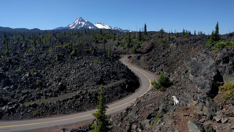
Sisters brings western themed storefronts and a friendly main street framed by the Cascade skyline.
The town serves as a launch point for trails, lakes, and lava flows that tell Oregon’s geologic story.
Summers favor hiking and cycling, and winters invite snowshoeing on gentle forest roads.
The McKenzie Pass Byway crosses old lava with viewpoints toward peaks and twisted black rock.
Dee Wright Observatory sits amid flows that stretch to the horizon under a clear sky.
Short paths reveal hardy plants that root in cinders and survive on little water.
Local shops offer maps, rentals, and advice that match your pace and interests.
Evening light warms wood facades and makes a relaxed stroll feel cinematic and calm.
Side streets lead to parks with playgrounds, shade, and clear mountain air.
Mountain weather can change fast, so layers help on routes that climb and descend.
Nearby lakes provide calm water for paddling before or after a scenic drive.
Trailheads are signed, and gravel pullouts make quick stops simple on less busy days.
This stop balances small town rhythm with access to big landscapes and open horizons.
It pairs well with Bend for a deeper dive into central Oregon recreation.
Address, Sisters Visitor Center, 291 E Main Ave, Sisters OR 97759.
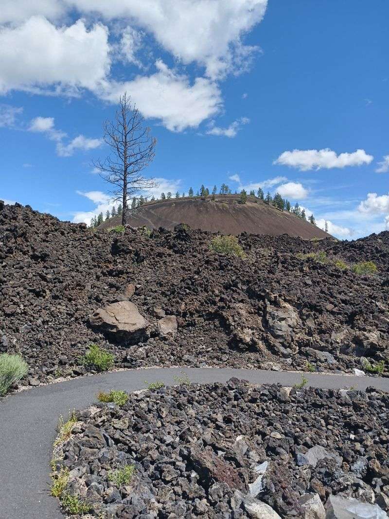
10. Bend and Newberry Volcanic Country
Bend blends riverfront parks with an easy to walk downtown that sits close to trail networks and lava fields.
Pathways along the Deschutes create a green thread that connects neighborhoods to scenic overlooks.
Newberry National Volcanic Monument reveals cinder cones, lava tubes, and broad obsidian flows within a short drive.
Wayfinding is straightforward, and visitor centers share current access details and maps for trail loops.
Daylight hours fill quickly with hikes, bike rides, and short scenic drives across high desert and forest.
Events and galleries add culture, while parks offer shady benches for a calm break in town.
Clear evenings bring crisp stars, and sunrise light warms rimrock and pine in subtle color.
Parking is manageable in signed lots near the river and downtown blocks.
The city works well as a base for exploring mountains, lakes, and caves across central Oregon.
Cinder soils and sharp rock favor sturdy shoes and water carried in comfortable packs.
Local guides help match difficulty to time frames when schedules are tight.
Scenic pullouts make it easy to photograph lava textures without long detours.
This chapter ties volcanic history to the broader route that began on the coast.
When ready, link south or west to close the loop across forests and valleys.
Address, Downtown Bend, 777 NW Wall St, Bend OR 97703.
11. Mount Bachelor and the High Cascades
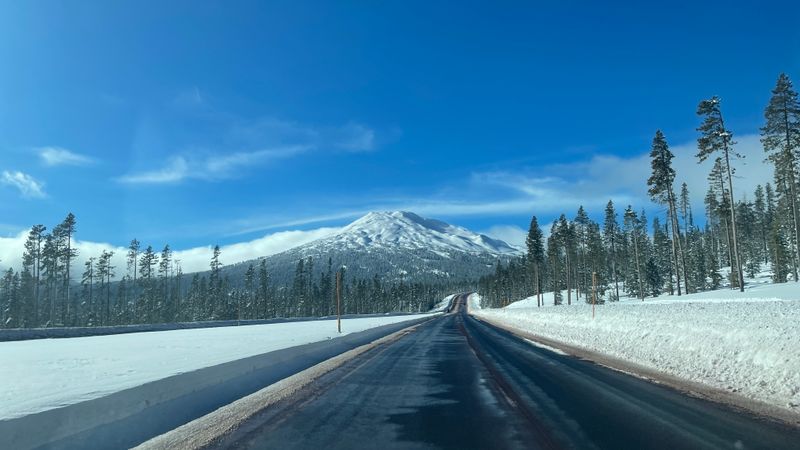
Mount Bachelor closes the loop with a high elevation scene that contrasts with Oregon’s coastline and dunes.
In winter it is a major ski area, and in summer it shifts toward hiking, biking, and scenic chair rides.
The Cascade Lakes Byway nearby touches Sparks, Elk, and Lava Lakes with views toward Broken Top.
Trailheads cluster around lake shores and meadows that hold lingering snow in cooler pockets.
Day use sites include boat ramps, restrooms, and picnic tables positioned for easy access.
Roadside turnouts present broad views of summits layered across the horizon in clear air.
Weather turns quickly at altitude, so plan layers and check forecasts before committing to long routes.
Wildflowers dot pumice flats in midsummer, and fall brings calm reflections on protected bays.
The mountain adds a final alpine chapter that complements earlier river and forest segments.
Evening light draws silhouettes across peaks that close the day with soft color.
Parking is straightforward at base areas when lifts operate in the warm season.
Look for interpretive signs that outline volcanic timelines and the shaping of the high plateau.
This area feels like a capstone where every Oregon landscape folds into one view.
From here, the route can swing back toward Bend or west toward valleys and the coast.
Address, Mt Bachelor West Village, 13000 SW Century Dr, Bend OR 97702.
Dear Reader: This page may contain affiliate links which may earn a commission if you click through and make a purchase. Our independent journalism is not influenced by any advertiser or commercial initiative unless it is clearly marked as sponsored content. As travel products change, please be sure to reconfirm all details and stay up to date with current events to ensure a safe and successful trip.