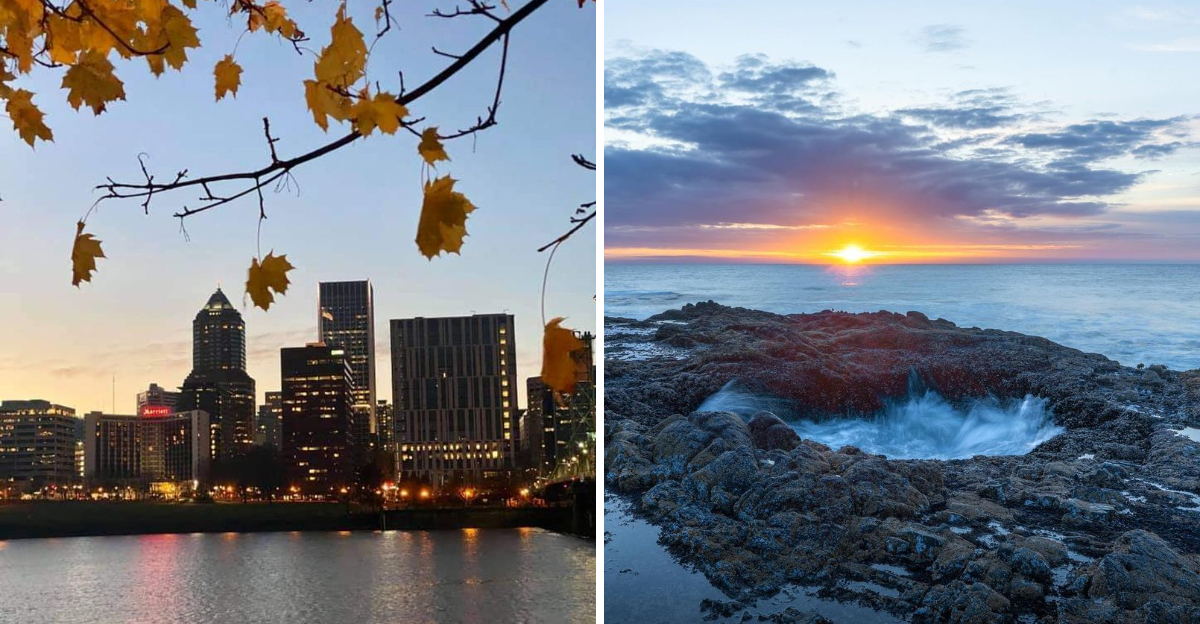
You have only two days to see Oregon, so let’s skip the usual crowds and slip into corner-of-the-map wonder.
This guide steers you to smaller pullouts, quiet loops, and scenery that feels like a secret shared in confidence.
You will get practical tips, exact addresses, and a route that respects how big this state really is.
Pack layers, cue the maps, and let Oregon surprise you at every turn.
1. Hidden Falls of the Columbia River Gorge
Begin with water and moss, because the Columbia River Gorge rewards early starts and short walks with instant drama.
Latourell Falls greets you with columnar basalt and a cool spray that travels into the parking area at 7300 Historic Columbia River Hwy, Corbett, OR 97019.
The loop stays gentle, making it perfect when time is tight but you still want a trail that feels like Oregon’s heartbeat.
Horsetail Falls sits just down the road at 85800 E Historic Columbia River Hwy, Cascade Locks, OR 97014.
Step behind the sheeted water at Ponytail Falls and feel the echo in your chest, then return to the highway as if nothing happened.
These stops keep your 48 hours flexible, letting you bank daylight for farther flung places later.
Carry non cotton layers, because gorge weather flips quickly and mist chills faster than you expect.
Parking fills at popular hours, so arrive early, then roll east before the caravans catch you.
Leave room for a side stop at Bridal Veil State Scenic Viewpoint, where a short path frames the river like a postcard.
Each waterfall feels intimate compared with the busiest viewpoints, and the basalt amphitheaters amplify birdsong.
Watch footing near wet rock, and keep eyes on falling debris after storms.
Cell signal fades in pockets, so download maps before you exit the interstate.
These quick wins set the tone for an offbeat Oregon sweep, dense with texture and low on stress.
When you pull back onto the Historic Highway, you will feel time expand, even if the clock insists otherwise.
2. Painted Hills at John Day Fossil Beds
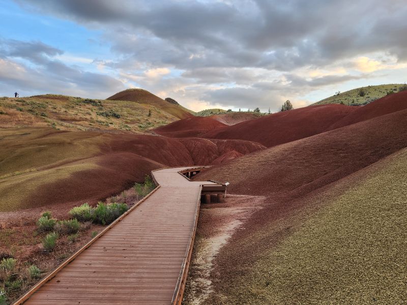
Color arrives in soft bands at Painted Hills, where clay soils turn the hillsides into a living gradient of ochre, red, and black.
Set your course to Painted Hills Unit, 32651 Bear Creek Rd, Mitchell, OR 97750.
Boardwalks protect the fragile surface, so keep to the path and let light do the work as clouds glide across the palette.
Each viewpoint reads like a timeline, and you can cover several short walks without losing your day.
Mornings and late day favor photography, while midday reveals fine detail in the soil’s texture.
This is high desert, so pack water and sun coverage even if Oregon made you expect forests.
The visitor center for the monument sits at 32651 OR 19, Kimberly, OR 97848, which helps with context across all three units.
Roads between units stretch longer than they look on a map, so choose Painted Hills if time is tight.
In spring, flowers sift color into the foreground, adding contrast that does not overwhelm the scene.
After rain, the bands deepen, but stay off wet clay to avoid damage and messy boots.
Facilities are limited, so plan rest stops and fuel in nearby towns before you commit.
Silence here feels generous, and you will likely hear your own footsteps between distant bird calls.
Oregon contains multitudes, and this unit proves it with a landscape that defies the evergreen stereotype.
Take a slow breath, align your schedule, and let the hills reset your idea of color.
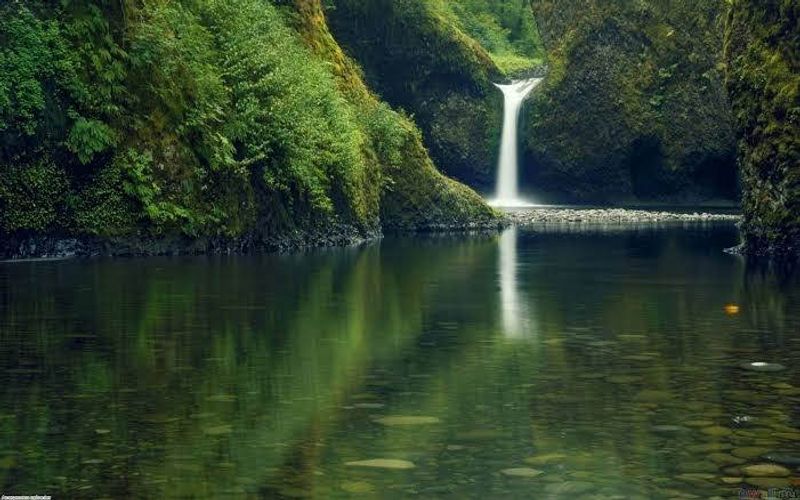
3. Blue Pool on the McKenzie River
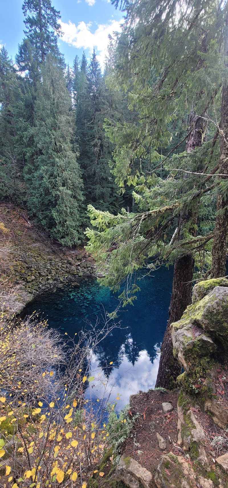
Water disappears underground, then reappears as an electric bowl called Tamolitch Blue Pool, clear enough to see stone stacked like glass.
Start at Tamolitch Falls Trailhead, McKenzie Hwy, Blue River, OR 97413.
The path weaves through lava rock and Douglas fir, firm underfoot with roots that ask for your attention.
Cold water looks inviting but stuns the body fast, so admire from the rim and keep your balance.
The river resurfaces here after traveling beneath lava, a process that explains that impossible clarity.
Oregon rewards respectful hikers, so yield space and stay patient at narrow sections.
Bring sturdy shoes, a warm layer, and a headlamp if daylight is limited by your schedule.
Parking is modest, and the approach road tightens, so arrive early or time your visit midweek.
Wildfire recovery work has improved safety, yet snags remain, especially after wind.
Cell service drops out, so download maps and let someone know your plan.
Nearby, the McKenzie River National Recreation Trail connects miles of forest if you crave more steps.
Return the way you came, noting how light shifts the pool’s color from turquoise to deep sapphire.
This stop fits a 48 hour plan by pairing well with the high desert or the coast.
When you leave, the quiet stays with you like a cool echo that follows the road.
4. Wallowa Mountains Escape
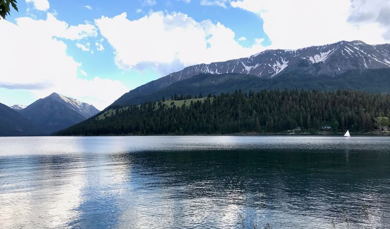
The northeast corner of Oregon feels like a different country, with granite walls and wide valleys stitched by clear rivers.
Base yourself in Joseph near Wallowa Lake State Park, 56554 Hwy 82, Joseph, OR 97846.
From the lakeshore, peaks mirror in calm water, and a tramway climbs high ridges for sweeping views in clear weather.
Trails branch into the Eagle Cap Wilderness with meadows that open like curtains after shaded switchbacks.
Carry layers, because mountain weather shifts and shade cools faster than you expect.
Main streets in Joseph showcase local art and carved totems that honor regional history.
The drive here is long, so count on full days and plan fuel before committing to backroads.
Wildlife moves at dawn and dusk, so slow down and give crossings the space they deserve.
This region keeps crowds thinner, which amplifies the feeling of distance and calm.
Stop by the Wallowa County Chamber, 101 W 1st St, Enterprise, OR 97828, for current trail and road updates.
Respect ranch gates and signage on county roads, and pull fully off for photo stops.
Campgrounds and lodges cluster around the lake, with quiet mornings that carry loons across the water.
Oregon’s big sky stretches widest here, and stars spread thick when clouds clear.
Leave no trace, pack out every scrap, and thank the trail with careful steps.
5. Quirky Oregon Coast at Thor’s Well
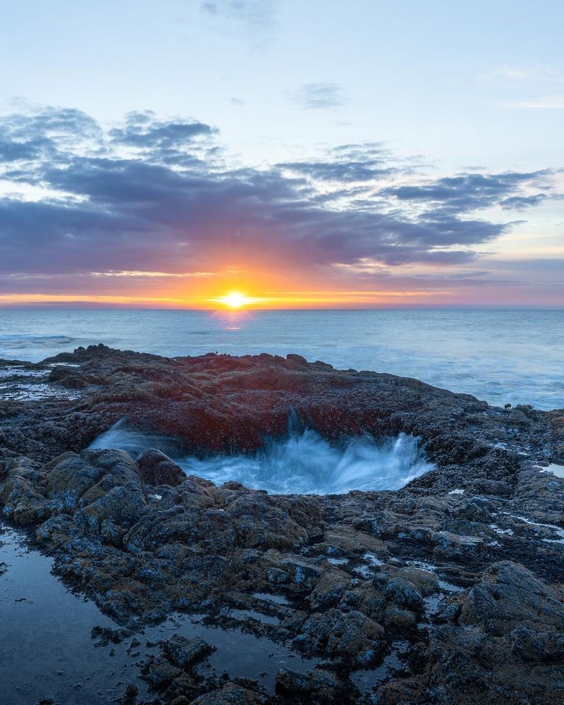
Waves breathe in and out of Thor’s Well, a natural opening in the rock that performs like a tide clock.
Park at Cape Perpetua Scenic Area, 2400 US 101, Yachats, OR 97498.
Trails lace the basalt headlands to Spouting Horn and Cook’s Chasm, each with railings and viewpoints.
Arrive near mid tide for the most movement, and stay well back when swells run large.
Non slip shoes matter here, because the rock grows slick and unpredictable with spray.
Interpretive signs explain how lava flows shaped this rugged section of the Oregon coast.
Wind carries salt into every jacket seam, so stash a dry layer for the drive.
The Cape Perpetua Visitor Center provides updates on tides, trail status, and seasonal closures.
Use pullouts for photos and give pedestrians space near the highway shoulders.
The forest above the cliffs softens the mood, offering quiet when the roar gets loud.
Time your visit around daylight, since the coastline turns shadowy and complex after dusk.
Benches face the horizon, perfect for catching your breath between viewpoints.
This stop pairs neatly with short hikes elsewhere on the central coast to keep your 48 hours balanced.
When you leave, the sound of water continues in your ears like a metronome for the road.
6. The Oregon Vortex and House of Mystery
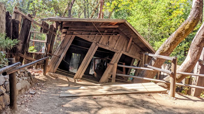
Perception tilts at the Oregon Vortex, where lines lean and your senses argue with your eyes.
Set your map to 4303 Sardine Creek L Fork Rd, Gold Hill, OR 97525.
Guided tours explain the optical tricks and the site’s history, with demonstrations that highlight slope and frame effects.
The setting sits among trees and old structures, which adds to the atmosphere without feeling staged.
Photography works best when you include a reference point, like a railing or doorframe.
Arrive with an open mind, then let the guide walk you through the illusions slowly.
Oregon holds plenty of scientific quirks, and this one entertains while sparking curiosity.
Comfortable shoes help on the uneven surfaces around the tilted building.
Check seasonal hours before you go, since schedules shift with daylight and weather.
Parking is on site, and staff keep groups moving in a steady rhythm.
Nearby trails along the Rogue River give you room to recalibrate after the tour.
Do not rush to conclusions, because the fun sits in noticing small changes as you move.
This interlude breaks up long driving blocks on a south to north Oregon itinerary.
Leave with a grin, and let the road iron out any lingering wobble.
7. Bend Basecamp and Local Flavor

Bend makes an ideal overnight base, with trails, river paths, and a compact downtown that rewards strolling.
Set your anchor near the Bend Visitor Center, 750 NW Lava Rd, Bend, OR 97703.
Walk the Deschutes River Trail at sunset, where footbridges link parks with soft light on Ponderosa trunks.
Downtown storefronts glow with warm interiors, and patios invite conversation even on cool evenings.
Smith Rock State Park sits within easy reach for morning hikes among welded tuff and sky.
Local roasters and bakeries fuel early starts without slowing your schedule.
Parking garages near Minnesota Avenue reduce circling and put you close to everything.
Weather swings between crisp mornings and bright afternoons, so dress in layers and keep sunglasses handy.
Public art dots corners, adding texture to quick loops between shops and galleries.
If you crave views, Pilot Butte State Scenic Viewpoint, 1310 NE Hwy 20, Bend, OR 97701, offers a paved climb above town.
Evenings feel relaxed, and the small city energy keeps stress off the itinerary.
Oregon road trips benefit from a central stop like this, where rest and access come easy.
Keep noise down after dark in residential streets, and let the stars carry the night.
Wake early, refill water, and push out toward the next landscape with calm focus.
8. Silver Falls State Park Waterfall Circuit
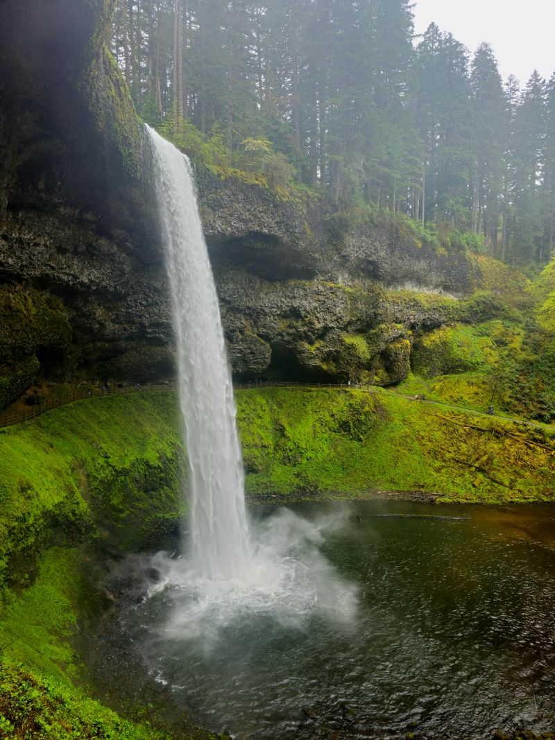
South of the capital, a looped path strings waterfalls like beads in a green cathedral.
Navigate to Silver Falls State Park, 20024 Silver Falls Hwy SE, Sublimity, OR 97385.
The Trail of Ten Falls curves behind curtains of water, where basalt caverns hum softly with mist.
Short connectors let you tailor the distance to your schedule without losing the highlights.
Footing can be slick near spray, so tread carefully and keep cameras on straps.
Facilities include picnic areas and a lodge, helpful when you need a quick regroup.
Salem sits close enough for a city detour, but the forest feels a world away.
Oregon shines in shoulder seasons here, with fewer people and extra moss on every surface.
Respect closures after storms, since downed limbs and rockfall take time to clear.
Park maps make it simple to link upper and lower loops with confidence.
Songbirds carry through the canyon, giving the walk a steady soundtrack without crowd noise.
Restrooms and water spigots reduce pack weight for this portion of your 48 hours.
When sunlight filters through, rainbows appear in the spray like quick signals.
End at the lodge porch and let the cool air settle your pulse before driving on.
9. No Pumping Gas, Oregon Style
Pull into a station in Oregon and you will likely be greeted by an attendant ready to handle the pump.
This tradition varies by county now, but stations still post clear instructions and provide service in many areas.
Ask the attendant how payment works at that location, then stay in the car unless directed otherwise.
Addresses change frequently, so use your map to find a well lit station near your route.
Fuel planning matters because distances between destinations stretch across big landscapes.
Save the attendant’s time by knowing your fuel grade, and unlock your cap before they arrive.
If you need air or windshield cleaning, many stations offer help when asked politely.
Late hours can reduce staffing, so be patient and keep headlights on for visibility.
Oregon road culture values safety, and this service keeps flow steady during busy travel days.
Do not step into lanes, and watch mirrors when doors open into traffic.
Receipts often print inside, which may require a quick stop at the window before you leave.
Use this pause to stretch, check maps, and sync your next stop with daylight.
The practice feels unusual if you are new to the state, but it quickly becomes second nature.
Thank the attendant, secure caps, and roll out calm and ready for the next highway segment.
10. Coast Tide Pools and Quiet Parks
Beyond the landmark beaches, small state parks hide tide pools where anemones open like slow fireworks.
Head for Neptune State Scenic Viewpoint, US 101 Milepost 168, Florence, OR 97439.
At low tide, basalt benches reveal star patterns in rock and tiny worlds between pools.
Bring soft soled shoes and step carefully to protect creatures and your ankles.
Interpretive signs explain safe viewing and the rhythm of tides along this stretch of Oregon coast.
Windbreaks behind driftwood make good photo spots when gusts pick up.
Pack a warm layer even in bright weather, because chill rides the breeze here.
Parking is limited, which helps keep the mood quiet and the walk unhurried.
Nearby Carl G. Washburne Memorial State Park, 93111 Hwy 101 N, Florence, OR 97439, offers forested trails and long sand.
Watch for sneaker waves and never turn your back on the ocean when you are near the edge.
Keep pets leashed around wildlife, and leave shells and rocks in place for others to enjoy.
This stop balances the drama of headlands with the intimacy of hand sized ecosystems.
Oregon’s coast rewards patience, and low tide windows often sneak outside the busiest hours.
Check tide tables, then let the pools edit your pace until the sea slides back in.
11. Drive Times and Route Strategy
Oregon looks compact on a map, but distances expand the moment you start weaving mountains, rivers, and coastlines.
Anchor your loop using hubs like Portland, Bend, and the central coast, then limit daily segments to keep margins.
Use rest areas for quick resets, and make room for unexpected closures that follow storms or summer work.
Download offline maps before you leave urban areas, since service fades in canyons and high desert.
Set fuel and food checkpoints, and mark parks with reliable restrooms to save time.
Start early, end before dark when possible, and let weather choose which direction you travel.
Highways like US 26, OR 126, and US 101 run scenic yet slow, thanks to curves and viewpoints.
Snow or fire can redirect plans, so check TripCheck, and ask rangers for current conditions.
Parking fills fast at small trailheads, which favors sunrise arrivals and weekday slots.
Stash paper maps as backup, and keep a headlamp accessible for surprise delays.
Think of the itinerary as a stack of cards, where you can shuffle based on daylight and mood.
This mindset turns a 48 hour sprint into a calm tour with space to breathe.
Oregon rewards flexible travelers, and the road will meet you halfway if you give it room.
End each day near your next morning’s start, and sleep comes easier when tomorrow is close.
Dear Reader: This page may contain affiliate links which may earn a commission if you click through and make a purchase. Our independent journalism is not influenced by any advertiser or commercial initiative unless it is clearly marked as sponsored content. As travel products change, please be sure to reconfirm all details and stay up to date with current events to ensure a safe and successful trip.