Oregon holds treasures far beyond the crowded tourist hotspots, tucked away on trails that wind through forests, canyons, and coastlines most visitors never discover.
Locals guard these paths like precious secrets, returning to them year after year for views that feel entirely their own.
From waterfalls hidden in lush ravines to alpine lakes reflecting volcanic peaks, these trails offer scenery so stunning it almost seems unreal. Many require just a bit of effort to reach, rewarding adventurous spirits with moments of pure wonder.
Some trails snake through ancient lava fields while others climb desert ridges overlooking winding rivers. Ready to explore Oregon like someone who actually lives here?
Pack your boots, grab plenty of water, and prepare for views that’ll make your Instagram followers seriously jealous. These 9 trails are about to become your new favorite escapes, and trust us, you’ll want to keep them secret too.
Who’s ready to trade crowded viewpoints for hidden gems only the locals know about?
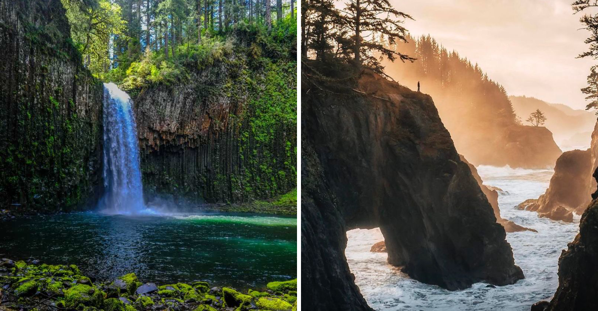
1. Abiqua Falls Near Scotts Mills
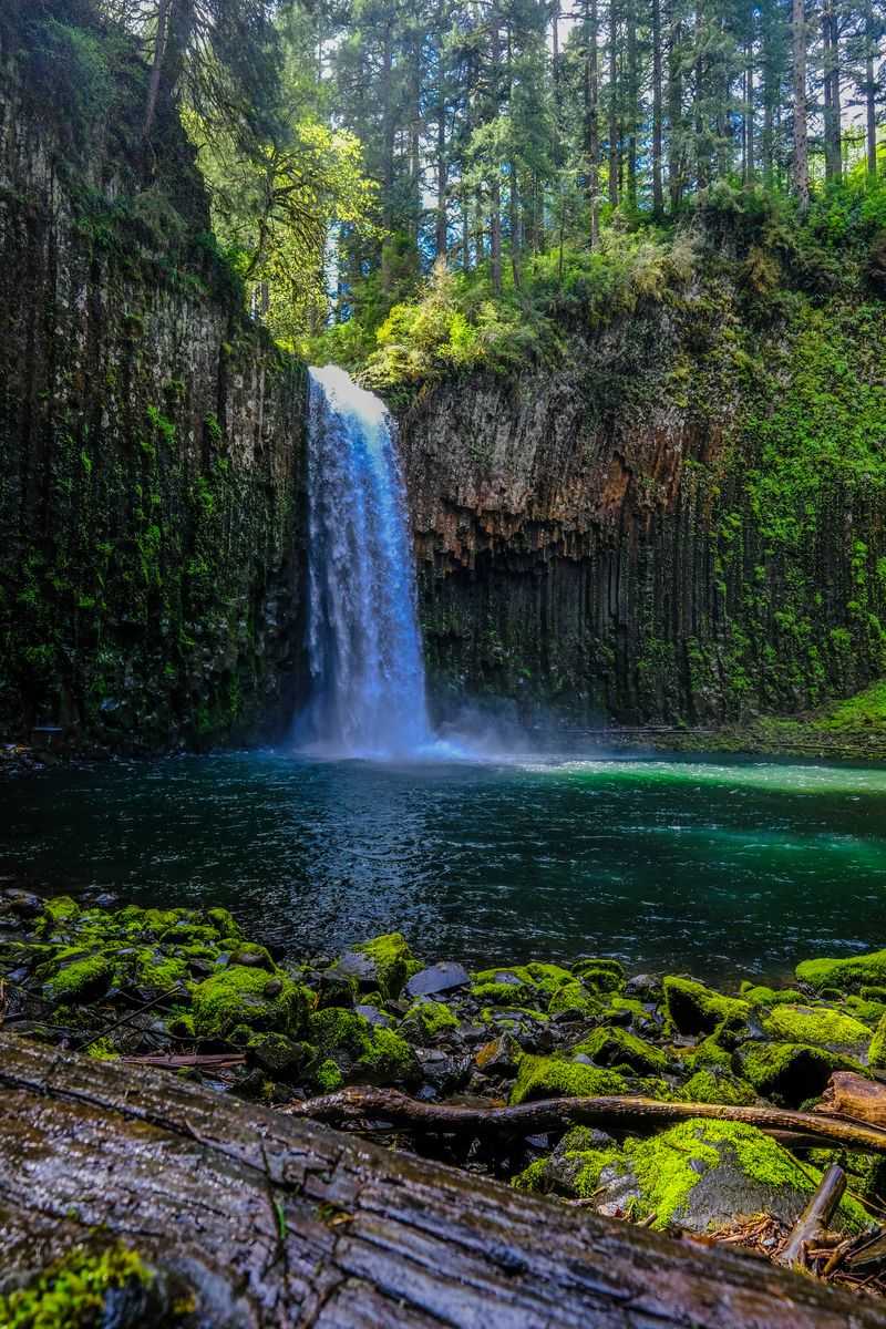
Tucked into a forested canyon near Scotts Mills, Abiqua Falls cascades into a natural amphitheater carved from ancient basalt columns, creating one of Oregon’s most photogenic hidden waterfalls. Getting there involves navigating a rugged gravel road that winds through private timber land, followed by a steep scramble down a sometimes muddy trail.
The journey keeps crowds away, making this spot feel like your own private discovery.
Once you reach the canyon floor, the view opens up dramatically. Water plunges roughly 92 feet from an overhang into a shallow pool surrounded by towering hexagonal rock formations.
Moss and ferns cling to every surface, adding vibrant greens that contrast beautifully with the dark stone.
Visiting during spring or early summer guarantees the strongest flow, though the falls run year round. Winter rains can make the access road impassable, and summer heat reduces the waterfall to a trickle.
Always check current road conditions before heading out, since four wheel drive is often necessary.
Photographers adore this location for its unique geological features and dramatic lighting. Midday sun filters down into the canyon, creating ethereal beams through mist.
Bring a wide angle lens to capture the full scope of the columnar basalt.
Local hikers recommend wearing sturdy boots with good traction, as the final descent can be slippery. Ropes are sometimes tied to trees to assist with the steepest sections.
Pack out everything you bring in to preserve this fragile environment for future adventurers seeking that perfect hidden waterfall experience.
2. Proxy Falls on McKenzie Pass
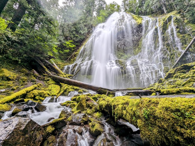
Two ethereal waterfalls await discovery along a short loop trail that winds through a landscape straight out of a fantasy novel. Proxy Falls sits within the McKenzie Pass area, where ancient lava flows created a surreal terrain of porous rock and towering old growth forest.
The trail stretches just over a mile, making it accessible for most fitness levels while delivering maximum visual impact.
Lower Proxy Falls is the showstopper, dropping approximately 200 feet in a wide, misty curtain that seems to vanish into the porous lava rock below. No visible pool forms at its base because water simply disappears into underground channels.
Upper Proxy Falls offers a different character, tumbling in multiple tiers through dense vegetation.
The best time to visit runs from late spring through early fall, after snowmelt swells the falls but before winter snows close the McKenzie Pass Highway. July and August bring wildflowers that carpet the forest floor between ancient lava formations.
Morning light creates magical conditions as sun filters through towering Douglas firs.
This trail feels mystical partly because of its unique geology. Volcanic activity thousands of years ago created the porous substrate that now swallows entire streams.
Moss draped trees and constant mist add to the otherworldly atmosphere, making you feel like you’ve stepped into an enchanted realm.
Locals love this spot for its combination of easy access and spectacular payoff. The well maintained path features minimal elevation gain, yet delivers scenery that rivals much longer hikes.
Bring a rain jacket even on sunny days, as mist from the falls keeps everything perpetually damp and wonderfully green.
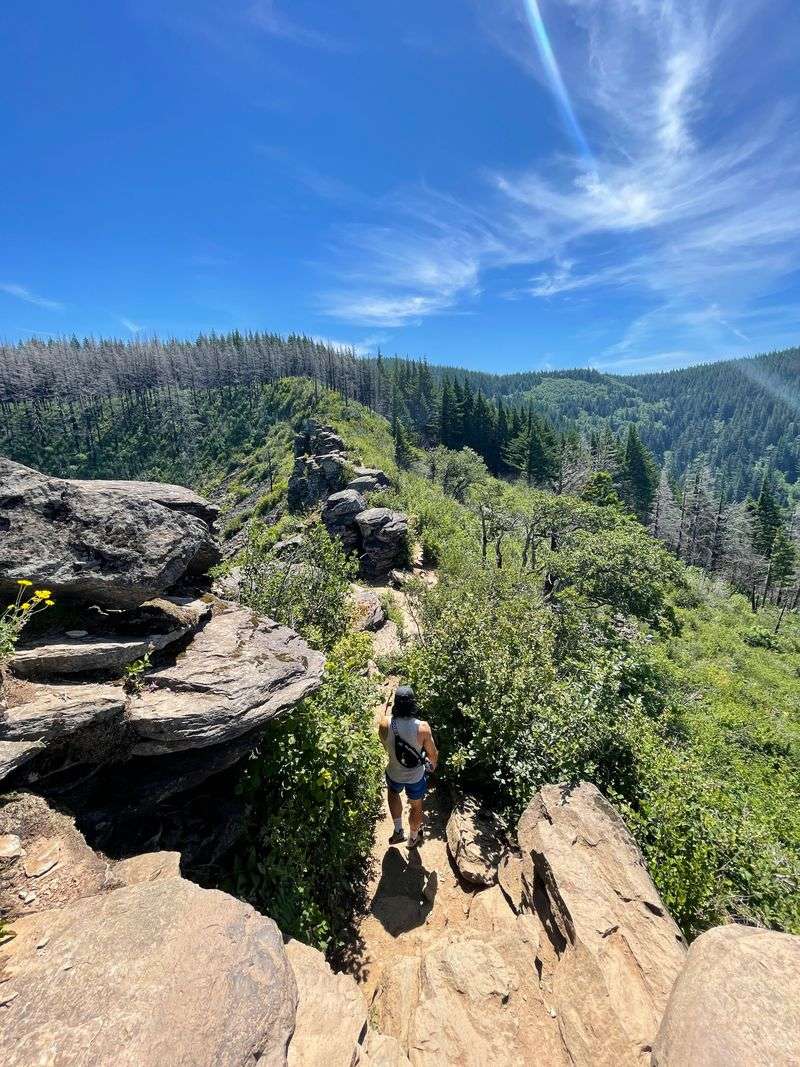
3. Samuel H. Boardman Scenic Corridor Trails
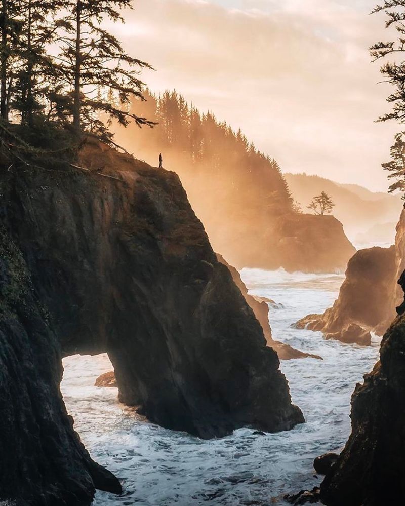
Stretching along twelve magnificent miles of southern Oregon’s rugged coastline, the Samuel H. Boardman Scenic Corridor hides numerous unmarked pullouts and trails leading to jaw dropping ocean vistas.
Most travelers zoom past on Highway 101, completely unaware of the sea stacks, natural arches, and secret beaches waiting just steps from the road. Locals know this stretch as the most dramatically beautiful coastal section in the entire state.
Dozens of short trails branch off the highway, each revealing different perspectives on this wild shoreline. Some descend to hidden coves where waves crash against towering rock formations.
Others climb headlands offering panoramic views stretching miles in both directions. Arch Rock, Natural Bridges, and Thunder Rock are just a few named features, but countless unnamed spots rival them in beauty.
Spring brings wildflowers that blanket the coastal bluffs in purple, yellow, and orange. Winter storms create the most dramatic wave action, though trails can become muddy and slippery.
Summer offers the calmest weather but also the most visitors, though even then this corridor remains relatively uncrowded compared to other Oregon coastal attractions.
Photographers find endless inspiration here, from sunrise shots over offshore rocks to sunset silhouettes of wind sculpted Sitka spruce. Tide pools teem with colorful sea stars and anemones during low tide.
Whales migrate past twice yearly, offering potential sightings from numerous clifftop vantage points.
Plan to spend several hours exploring multiple pullouts rather than rushing through. Each viewpoint offers something unique, whether it’s a different angle on the coastline or access to a secluded beach.
Wear layers since coastal weather changes quickly, and always watch for sneaker waves when exploring near the water.
4. Misery Ridge Trail at Smith Rock State Park
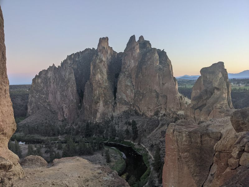
Challenging switchbacks climb relentlessly up the western face of Smith Rock, earning this trail its ominous name while delivering some of central Oregon’s most spectacular high desert panoramas. Located at Smith Rock State Park near Terrebonne, the Misery Ridge Trail tests your endurance with steep grades and exposed sections, but the payoff makes every burning muscle worthwhile.
Locals tackle this route regularly, knowing the views from the top showcase the Crooked River canyon in all its glory.
The trail begins at the main parking area and immediately drops to cross a footbridge over the Crooked River. From there, the real work starts as you ascend roughly 800 feet in less than a mile.
Exposed rock faces and minimal shade make this section brutal on hot summer days, so most experienced hikers start early morning or wait until evening.
Summit views span 360 degrees, taking in the volcanic Cascade peaks to the west, endless high desert to the east, and the sinuous Crooked River carving through golden rock walls below. Rock climbers appear as tiny figures on vertical faces, adding scale to the massive formations.
The entire landscape glows orange and red during golden hour, creating unforgettable photo opportunities.
Spring and fall offer the most comfortable hiking conditions, with moderate temperatures and occasional wildflowers dotting the desert terrain. Winter brings snow and ice that can make the trail dangerous.
Summer heat regularly exceeds 90 degrees, requiring multiple liters of water and sun protection.
The trail continues beyond the summit, connecting to other routes for extended loops. Most hikers descend via the same route or continue around to create a loop via the Mesa Verde Trail.
Either way, expect this hike to take two to four hours depending on your pace and photo stops.
5. Green Lakes Trail in South Sister Wilderness
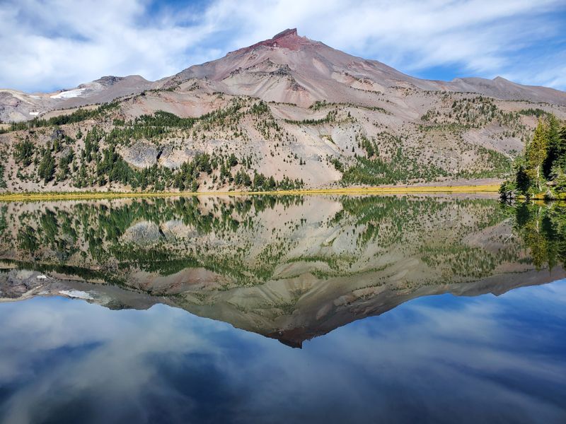
Alpine perfection awaits at the end of this classic Cascade mountain trail, where three emerald colored lakes nestle beneath the towering volcanic peak of South Sister. The Green Lakes Trail ranks among Oregon’s most beloved high country hikes, combining moderate difficulty with scenery that defines the state’s mountain wilderness.
Locals return year after year, timing their visits for wildflower season or golden fall colors.
Starting from the Green Lakes Trailhead west of Bend, the path climbs steadily through old growth forest before emerging into open meadows. Total distance runs about nine miles round trip with roughly 1,100 feet of elevation gain.
The grade remains manageable for most hikers, though the length and altitude can challenge those unaccustomed to mountain conditions.
As you approach the lakes, the landscape transforms into a stunning alpine basin. Broken Top’s jagged summit rises to the north while South Sister dominates the southern skyline.
The lakes themselves shimmer in shades of turquoise and green, colored by glacial flour suspended in the water. Camping is restricted to designated sites due to heavy use, and permits are required during peak season.
July through September offers the most reliable access, as snow lingers into early summer at this elevation. Wildflowers peak in late July and early August, carpeting meadows in lupine, paintbrush, and countless other species.
Fall brings golden larches and crisp air, though nights turn freezing cold.
Day hikers should start early to secure parking and allow plenty of time for the round trip journey. Bring layers since mountain weather changes rapidly, and afternoon thunderstorms are common in summer.
The trail can be dusty and exposed in sections, so sun protection and plenty of water are essential for enjoying this spectacular slice of Oregon’s volcanic highlands.
6. Trail of Ten Falls at Silver Falls State Park
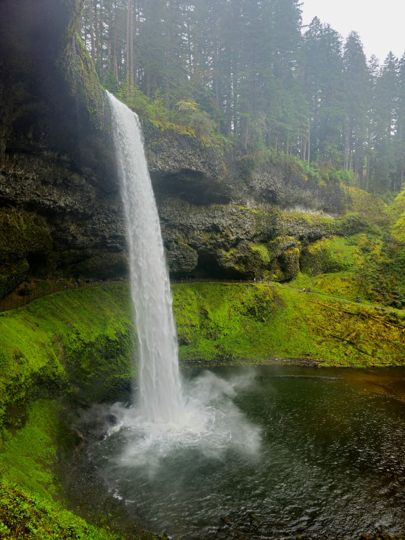
Oregon’s largest state park harbors an extraordinary loop trail that passes behind multiple waterfalls, creating an immersive rainforest experience unlike anything else in the Pacific Northwest. The Trail of Ten Falls lives up to its name by showcasing ten distinct waterfalls ranging from 27 to 177 feet tall.
Located near Salem at 20024 Silver Falls Hwy SE, Sublimity, OR 97385, this magical circuit draws visitors year round yet somehow maintains a peaceful atmosphere.
The full loop covers 7.2 miles of moderate terrain through old growth forest, alongside rushing creeks, and behind curtains of falling water. South Falls, the tallest at 177 feet, greets hikers early in the journey with a trail that actually passes behind the cascade.
Walking through the misty grotto while water thunders overhead creates an unforgettable sensory experience.
Each waterfall offers unique character. Some plunge in single drops while others cascade in tiers.
Several feature basalt amphitheaters carved over millennia by relentless water flow. The trail alternates between forested sections and open areas near the falls, providing constant variety and numerous photo opportunities.
Winter and spring bring the highest water volume, making falls more dramatic but trails potentially muddy. Fall colors add golden and orange hues to the forest canopy.
Summer offers the driest conditions though water flow decreases somewhat. Regardless of season, this trail delivers spectacular scenery.
Families appreciate the well maintained paths and relatively gentle grades, though the length can tire younger children. Multiple access points allow shorter out and back options if the full loop feels too ambitious.
Arrive early on weekends to secure parking, as this popular destination fills quickly. Restrooms and facilities at the trailhead make this an accessible adventure for hikers of all experience levels seeking that quintessential Oregon waterfall experience.
7. Angels Rest in Columbia River Gorge
Perched high above the Columbia River, Angels Rest delivers sweeping 360 degree views that encompass the entire Gorge landscape, from Washington’s mountains to Oregon’s waterfalls. This moderately steep trail near Portland offers one of the most rewarding view to effort ratios in the Gorge, climbing about 1,500 feet over 2.5 miles.
Locals hit this trail regularly for sunrise hikes or evening strolls, knowing the summit vista never gets old.
The trailhead sits just off Historic Columbia River Highway near Bridal Veil, making it easily accessible from Portland in under 45 minutes. Switchbacks climb steadily through Douglas fir forest, occasionally opening to partial views that hint at the spectacular panorama awaiting above.
The grade challenges beginners but remains manageable for anyone with basic fitness.
Summit rocks provide perfect spots to rest and absorb the incredible scenery. The Columbia River stretches east and west like a silver ribbon between steep canyon walls.
On clear days, Mount Hood dominates the eastern skyline while Mount St. Helens and Mount Adams rise to the north. Crown Point and Vista House appear as tiny landmarks far below.
Spring wildflowers dot the trail, while fall brings golden foliage and crisp air. Winter can bring ice and snow that make the upper sections treacherous without proper footwear.
Summer heat makes early morning starts preferable, though sunset hikes are equally popular for the golden light display.
The 2017 Eagle Creek Fire burned through this area, leaving visible scars but also opening up views that were previously obscured by dense forest. Vegetation is recovering nicely, adding new layers of green each year.
Bring plenty of water since no sources exist along the trail, and consider trekking poles for the steep descent that can be hard on knees after enjoying those magnificent Gorge views from your rocky perch.
8. John Dellenback Dunes Trail
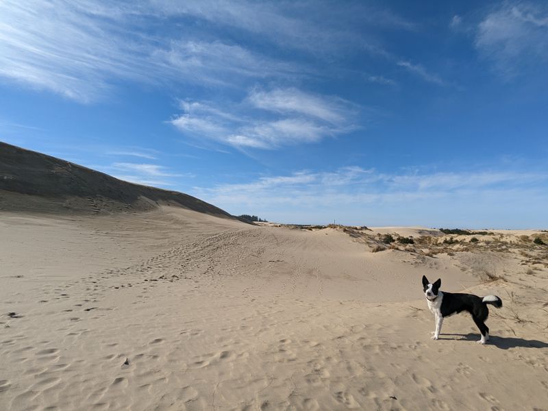
Massive sand dunes rise and fall like frozen ocean waves along Oregon’s central coast, creating a landscape more reminiscent of the Sahara than the Pacific Northwest. The John Dellenback Dunes Trail explores the heart of the Oregon Dunes National Recreation Area, where towering sand formations meet dense coastal forest in a constantly shifting ecosystem.
Locals know this as one of the few places in Oregon where you can experience genuine desert conditions mere miles from crashing surf.
The trail begins from the Eel Creek Campground area and immediately enters a world of sand. Marked posts guide hikers across approximately 2.5 miles of open dunes, though the soft surface makes distance feel longer.
Some dunes rise over 150 feet tall, offering panoramic views of the surrounding landscape once you summit their wind sculpted peaks.
Reaching the ocean requires hiking the full distance to the beach, where dunes give way to hard packed sand and waves. The journey feels like crossing multiple ecosystems, from forest edge through pure sand desert to coastal beach.
Each zone supports different plants and wildlife adapted to harsh conditions.
Summer brings warm temperatures perfect for barefoot hiking, though sand can become scorching hot by afternoon. Spring and fall offer cooler conditions and fewer visitors.
Winter storms reshape the entire dune field, creating new formations and erasing old paths. Always carry plenty of water since no shade exists once you leave the forest edge.
Photographers love the clean lines and dramatic shadows created by wind sculpted sand ridges. Sunrise and sunset paint the dunes in shades of gold and orange.
Footprints disappear within hours as wind constantly reworks the surface, giving each visit a pristine quality. This unique Oregon landscape offers adventure seekers a chance to experience coastal desert unlike anywhere else in the state.
9. Smith Rock State Park Desert Canyon Trails
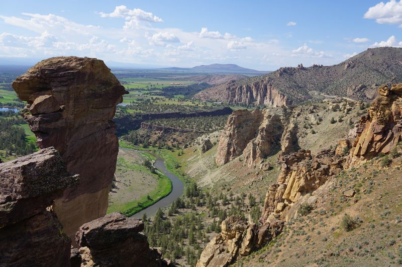
Beyond the famous Misery Ridge climb, Smith Rock State Park offers an entire network of trails exploring the high desert canyon carved by the Crooked River. Located at 9241 NE Crooked River Dr, Terrebonne, OR 97760, this geological wonderland attracts rock climbers from around the world while hikers discover quieter paths revealing the park’s full beauty.
Locals appreciate how different trails showcase varying perspectives on the same stunning landscape.
The River Trail follows the Crooked River along the canyon floor, offering easy walking with constant views of towering rock faces. Climbers dangle from vertical walls above while hikers enjoy level terrain below.
This path connects to numerous other routes, allowing custom loop options of varying difficulty. Monkey Face, a distinctive rock formation resembling its namesake, dominates views from many angles.
Spring transforms the typically brown desert with surprising wildflower displays. Balsamroot and lupine add splashes of yellow and purple to hillsides usually painted in earth tones.
Summer heat can be intense, making early morning or evening visits most comfortable. Fall brings pleasant temperatures and golden light that photographers adore.
Winter offers solitude and occasional snow dusting the red rocks.
Wildlife includes golden eagles, prairie falcons, and river otters along the waterway. Lizards scurry across sun warmed rocks while mule deer browse vegetation in shaded areas.
The high desert ecosystem supports surprising biodiversity despite harsh conditions.
Day use fees apply, and parking fills quickly on nice weekends. Multiple trailheads provide access to different sections of the park.
Bring substantially more water than you think necessary since desert heat and lack of shade create rapid dehydration. The unique landscape feels worlds away from Oregon’s wet forests, offering adventurers a completely different side of the state’s natural beauty in one spectacular desert canyon.
Dear Reader: This page may contain affiliate links which may earn a commission if you click through and make a purchase. Our independent journalism is not influenced by any advertiser or commercial initiative unless it is clearly marked as sponsored content. As travel products change, please be sure to reconfirm all details and stay up to date with current events to ensure a safe and successful trip.