Seven thousand years ago this Oregon volcano exploded, scattered ash for miles, and then went quiet. Today it stands five hundred feet tall at the heart of a national monument, a perfect cinder cone that looks like a child’s drawing of a mountain.
You can drive or walk to the summit, then stare down into the dark crater where red and black rocks tell the story of an ancient eruption. The views from the top stretch across a vast lava field that looks more like Mars than Earth.
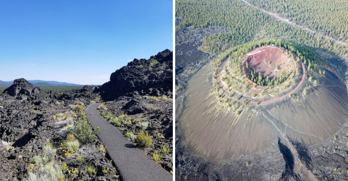
A fire lookout perches on the very edge, staffed by volunteers who spend their days watching for smoke and chatting with visitors. The trail loops around the crater rim and takes about twenty minutes at a slow pace, though the elevation might leave you breathing hard.
Oregon has plenty of dramatic mountains, but this one feels approachable and raw, a volcano you can actually touch. The surrounding monument offers miles of trails through twisted lava formations, underground caves, and hardy trees that somehow take root in solid rock.
A Volcano That Has Been Quietly Waiting for 7,000 Years

Most things that are 7,000 years old are buried underground or locked in a museum. Lava Butte sits right out in the open, completely unapologetic about its age.
It formed during a volcanic eruption that sent lava flows spreading across the landscape, covering what is now central Oregon in hardened black rock.
The eruption happened in geological terms not that long ago. Ancient humans were already walking the earth when this volcano blew.
That thought alone made the hike feel a little more electric.
The cinder cone shape is almost perfectly preserved. It rises sharply from the flat lava fields below, and the crater at the top is still clearly visible.
Scientists study it as a textbook example of cinder cone formation. For the rest of us, it is just a stunning and humbling reminder that the ground beneath Oregon has a very lively history.
Standing here, the word ancient stops feeling abstract and starts feeling very, very real.
Rising 500 Feet Above the Lava Fields Below

The height of Lava Butte catches people off guard. From the highway, it looks like a dark hill in the distance.
Once you start climbing, you realize it is much steeper and taller than it appears from the road.
The summit sits roughly 500 feet above the surrounding lava fields. That elevation gain rewards you with a panoramic view that feels genuinely earned.
The trail around the rim is about a quarter mile long, and it circles the entire crater edge.
A few sections have loose pumice gravel underfoot, so wearing sturdy shoes makes a real difference. The path is not extremely difficult, but it is not a casual stroll either.
Kids and adults with a reasonable fitness level handle it well. The steep drop on one side of the rim gives you a serious sense of scale.
Looking straight down into the crater and then out across miles of hardened lava is one of those views that stays with you long after you leave.
The Heart of Newberry National Volcanic Monument

Newberry National Volcanic Monument is not exactly a household name outside of Oregon. That is a real shame, because it covers over 55,000 acres of remarkable volcanic landscape.
Lava Butte stands right at its northern edge, acting as a natural gateway into the monument.
The monument includes lava tubes, obsidian flows, crater lakes, and more cinder cones than most people expect. It is managed by the U.S.
Forest Service under the Deschutes National Forest. The scale of the place is hard to wrap your head around at first.
Visiting Lava Butte gives you a solid introduction to what the monument offers. The Lava Lands Visitor Center nearby provides excellent context about the geological forces that shaped the region.
Rangers there are genuinely enthusiastic and happy to point you toward the best spots. America the Beautiful national parks passes are accepted here, which makes access easy for frequent park visitors.
The monument deserves far more attention than it typically gets.
Taking the Shuttle Ride to the Top

Driving your own vehicle to the summit is not always an option. During busy seasons, a shuttle service runs from the visitor center to the top, and honestly, it adds a fun layer to the visit.
The ride is short, only a few minutes each way.
The shuttle costs a small fee per person, and it runs on a regular schedule every 20 minutes or so. Having exact change ready is a smart move, since the shuttle does not always provide change.
The bus winds up the access road with views opening up on both sides as you climb.
For families with young kids or anyone who prefers not to hike the full road, the shuttle is a genuinely good option. It drops you right at the summit area, where the rim trail begins.
The return trip is typically included in the fare. Hikers who want to walk up can do so via the access road, which runs about a mile at a steady uphill grade.
Both options work well depending on your energy level.
360-Degree Views of the Cascade Range

The view from the summit is the kind that makes people stop mid-sentence. On a clear day, the Cascade Range lines up across the horizon like a postcard that somehow got real.
Mount Bachelor, the Three Sisters, Broken Top, and even Mount Hood in the far distance are all visible.
A fire lookout sits at the top, and inside it you will find panoramic maps that label each peak. Those maps are incredibly useful for identifying what you are looking at.
The ranger stationed at the top is also happy to help and share a bit of history if you ask.
Early morning visits tend to offer the clearest sightlines, especially for photographing the mountains to the west. The sun sits behind you in the morning, which makes the light much better for photos.
Even on a slightly hazy day, the view across the lava fields below is dramatic. Arriving early also means fewer people on the rim trail, which makes the whole experience feel more personal and peaceful.
Walking the Rim Trail Around the Crater

The quarter-mile rim trail is one of those short hikes that punches well above its weight. It circles the entire crater at the top of the cone, offering constantly shifting views as you move around the rim.
Each angle reveals something slightly different about the landscape below.
The path has some loose pumice underfoot, which makes it feel a bit like walking on coarse sand. It is manageable for most visitors, though a little extra care is needed on steeper sections.
The crater itself drops steeply inward, and looking down into it gives a vivid sense of what this place once was.
The full loop takes about 20 minutes at a relaxed pace. There is no need to rush.
Taking time to stop, look around, and just absorb the scale of the volcanic landscape makes the walk much more rewarding. Visitors are asked to keep summit time to about 30 minutes during busy periods to allow others access.
That is plenty of time to enjoy the trail and take in the remarkable surroundings.
What the Lava Lands Visitor Center Teaches You

Before heading up the butte, spending time in the Lava Lands Visitor Center is genuinely worthwhile. The exhibits cover the volcanic history of the entire Newberry region in a way that is easy to follow and surprisingly engaging.
It is not dry science, it is storytelling through rocks and maps.
The center opens at 10am and the staff there are notably knowledgeable. Rangers can give you a solid overview of the monument and help you plan what to see based on your interests and available time.
They also issue passes for the access road when driving is permitted.
Interactive displays explain how lava flows move, how cinder cones form, and what makes Newberry so geologically significant. For families with kids who love volcanoes, this is basically a dream stop.
The visitor center also covers nearby attractions like lava tube caves and obsidian flows. Even if you only have an hour to spare, the combination of the visitor center and the butte itself makes for a complete and satisfying experience.
Exploring the Lava Flow Trails at the Base

The trails at the base of Lava Butte offer a completely different perspective than the summit. Down here, you are walking through the actual lava flow, surrounded by twisted black rock formations and scattered pine trees that somehow took root in the hardened surface.
Interpretive signs line the paths and explain how the lava moved, cooled, and eventually became the landscape you are standing in. The information is written clearly and accessibly, which makes it easy for all ages to follow along.
Some of the rock formations are genuinely striking up close.
The western end of the trail opens onto a viewing area that faces Mount Bachelor, the Three Sisters, and Broken Top. Early morning light hits these peaks beautifully from this angle.
The path itself is well-maintained and relatively flat, making it accessible for most visitors. Walking through a real lava field, even a 7,000-year-old one, carries a certain quiet intensity.
Tips for Planning Your Visit to Lava Butte

A little planning goes a long way at Lava Butte. The site is located just off Highway 97, about 11 miles south of Bend, making it an easy stop on a road trip through central Oregon.
The access is straightforward and well-signed from the highway.
Parking is available at the visitor center, but summit parking is limited. During summer months, the shuttle is often the best way to reach the top.
Arriving early in the day helps avoid crowds and gives you the best light for photos.
America the Beautiful passes are accepted here, which is a nice bonus for national park regulars. The visitor center opens at 10am, so planning your arrival around that time makes sense if you want the full experience.
Wear layers, since the summit can be noticeably cooler and windier than the base. Sturdy shoes with good grip handle the loose pumice trail much better than sandals or casual sneakers.
Why Lava Butte Belongs on Every Oregon Road Trip

Central Oregon has no shortage of dramatic landscapes, but Lava Butte stands apart from most of them. It is not just a pretty view, it is a real geological event frozen in time.
Few places let you stand directly on top of a volcanic cone and look out across the damage it caused thousands of years ago.
The combination of easy access, affordability, and genuine visual impact makes it a standout stop. It works well as a quick detour off Highway 97 or as a dedicated half-day excursion from Bend.
Either way, it delivers.
Travelers heading toward Crater Lake often pass right by without stopping. That is a missed opportunity.
Lava Butte takes maybe two hours of your time and gives back something that is hard to find elsewhere in the state. The sense of scale, the volcanic history, the panoramic Cascade views, and the quiet intensity of the lava fields all combine into something genuinely memorable.
Dear Reader: This page may contain affiliate links which may earn a commission if you click through and make a purchase. Our independent journalism is not influenced by any advertiser or commercial initiative unless it is clearly marked as sponsored content. As travel products change, please be sure to reconfirm all details and stay up to date with current events to ensure a safe and successful trip.