Some towns fade slowly, slipping into obscurity over decades. Others are abandoned suddenly, their streets left silent overnight.
This Oklahoma town belongs to a third, stranger category. It was swallowed by nature, a once-bustling mining hub that now sits empty, its crumbling buildings slowly being reclaimed by trees and weeds.
The town was a lead and zinc mining powerhouse for nearly a century, producing billions in ore during World War I and World War II. At its peak, Picher housed over 20,000 people, with schools, churches, and a bustling downtown.
But the mining left behind a toxic legacy, mountains of chat waste and contaminated water that eventually led to a government buyout in 2009. Today, the population hovers around a few dozen, and the streets are lined with abandoned homes, storefronts, and rusted machinery.
The silence here is heavy. Vines creep through broken windows and trees push through cracked pavement.
The chat piles loom in the distance like strange gray mountains, and the whole place feels like a post-apocalyptic movie set.
The Rise of a Mining Powerhouse

Few towns in American history rose as fast or as dramatically as Picher, Oklahoma. Lead and zinc were discovered in the area around 1914, and within just a few years, the town exploded into one of the most productive mining centers in the entire country.
At its peak in the 1920s, Picher had a population of nearly 20,000 people. Businesses, schools, churches, and neighborhoods all sprouted up almost overnight to support the booming workforce.
The Tri-State Mining District, which covered parts of Oklahoma, Kansas, and Missouri, was one of the richest mineral deposits ever found in North America. Picher sat right at the heart of it.
The mines here supplied a huge portion of the lead and zinc used during both World War I and World War II. That contribution alone made Picher a critical part of American history.
Standing in the town today, it is almost impossible to picture the energy and ambition that once filled these streets. The contrast between what was and what remains is one of the most striking things about this entire place.
Chat Piles: The Toxic Mountains Left Behind

The most visually striking feature of Picher today is something that most towns would never want: enormous mounds of mining waste known as chat piles. These gray, gravelly heaps tower over the flat Oklahoma landscape in a way that feels completely surreal.
Chat is the crushed rock and mineral waste left over after lead and zinc are extracted from ore. Decades of mining produced millions of tons of this material, and it was simply piled up throughout and around the town.
The chat piles are not just an eyesore. They are genuinely toxic.
Rain and groundwater carry heavy metals like lead and cadmium from the piles into the soil and local waterways, creating serious contamination that has persisted for decades.
The Environmental Protection Agency designated Picher and the surrounding area as part of the Tar Creek Superfund Site, one of the most contaminated places in the United States.
Even now, the chat piles remain a defining part of the Picher landscape. They are hard to photograph without feeling a strange mix of awe and unease, because they are both visually dramatic and deeply sobering reminders of environmental cost.
Tar Creek and the Water Contamination Crisis

One of the most alarming chapters in Picher’s story involves Tar Creek, the waterway that runs through the area and became a symbol of the town’s environmental disaster. The creek turned a vivid orange-red color due to heavy concentrations of iron and other metals leaching from old mine shafts.
When the mines were abandoned, they began flooding with groundwater. That water mixed with sulfide minerals in the rock, creating acidic runoff that drained directly into Tar Creek.
The contamination spread far beyond the creek itself. Soil samples throughout residential areas of Picher revealed dangerously high levels of lead, particularly in places where children played.
Lead poisoning causes serious developmental problems in young children, and testing confirmed that many local kids had elevated blood lead levels.
The Tar Creek Superfund designation brought federal attention and funding to the area, but cleanup proved far more complicated than anyone anticipated. The underground mine tunnels had created a vast, invisible network of contamination beneath the town.
Standing near Tar Creek today, the water still carries that rust-colored tint in places. It is a quiet but powerful visual reminder that what happens underground does not always stay underground.
The Sinkholes Swallowing the Ground Beneath the Town

If the chat piles and contaminated water were not enough, Picher also faced a danger hiding directly beneath its streets. Decades of underground mining had carved out a massive honeycomb of tunnels beneath the town, and those tunnels were beginning to collapse.
Sinkholes started appearing throughout Picher with alarming frequency. Streets cracked.
Foundations shifted. Entire sections of ground simply gave way without warning.
Engineers who studied the situation found that roughly a third of the land beneath Picher was considered unstable. The town was, quite literally, built on hollow ground.
This discovery accelerated the government’s push to relocate residents. The combination of toxic soil, contaminated water, and unstable ground made staying in Picher not just unpleasant but genuinely dangerous.
A federal buyout program was established to help residents leave, and most people accepted the offer. By the mid-2000s, the population had dropped to just a few hundred people from its historic peak of nearly 20,000.
Walking through Picher now, you can still see places where the earth has shifted and buckled. The ground itself seems to be slowly pulling the town apart, one quiet collapse at a time.
The Tornado of 2008 and the Final Blow

By 2008, Picher was already a town in the final stages of abandonment. Most residents had accepted buyouts and moved away.
Schools had closed. Businesses were long gone. And then, on May 10, 2008, a powerful tornado tore directly through what remained.
The tornado was rated EF4, with winds estimated at around 170 miles per hour. It caused widespread destruction across the region, and Picher, with its empty and deteriorating buildings, took a devastating hit.
Several people who had refused to leave the town were affected by the storm. The tornado served as a brutal punctuation mark on a story that had already been heading toward an inevitable end.
After the tornado, the state of Oklahoma officially disincorporated Picher. The town that had once been a thriving industrial hub was no longer legally recognized as a municipality.
The combination of environmental contamination, ground instability, and the tornado created a situation that left almost nothing functional standing. What the mines did not destroy over decades, the storm finished in minutes.
Visiting the site today, you can still find traces of that destruction mixed in with the slower decay of abandonment. Nature has been working steadily ever since to fill in the gaps.
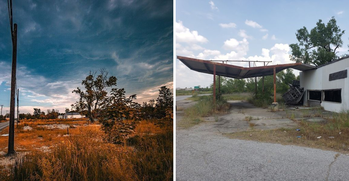
What Remains: Exploring the Abandoned Structures

Stepping into the remains of Picher feels like walking through a place that the rest of the world simply forgot about. Crumbling foundations, broken sidewalks, and the occasional shell of a building are scattered across what were once busy residential streets.
Some structures still have recognizable features: a doorframe here, a section of roof there, a staircase leading up to nothing. Nature has moved in aggressively, with trees and shrubs pushing through floors and walls.
The old mining infrastructure is also still visible in places. Rusted equipment, concrete foundations from processing facilities, and remnants of industrial buildings dot the landscape alongside former homes and businesses.
One of the most haunting aspects of exploring Picher is how personal some of the remnants feel. A cracked bathtub sitting in an open lot.
A concrete front step with no house attached. These small details make the abandonment feel very real and very human.
Oklahoma’s wild vegetation grows fast and thick, and it has embraced Picher with enthusiasm. Vines climb old walls, grasses push through asphalt, and young trees sprout from the foundations of buildings that once housed families.
The town is being quietly swallowed, and the process is both beautiful and deeply melancholy.
The Quapaw Nation and the Land’s Deeper History

Long before lead and zinc drew miners to this corner of northeastern Oklahoma, the land around Picher was home to the Quapaw Nation. The Quapaw people were relocated to this region in the 1800s as part of the federal government’s forced removal of Indigenous nations from their original homelands.
The mining boom that built Picher took place largely on land that had been allotted to Quapaw tribal members. Leases were signed, royalties were paid, and the industrial transformation of the landscape began on ground that held deep cultural and historical meaning for the Quapaw people.
The environmental damage caused by mining fell heavily on Quapaw land. The Tar Creek Superfund Site overlaps significantly with Quapaw tribal territory, and the community has been involved in cleanup and restoration efforts for decades.
The Quapaw Nation has actually taken an active leadership role in environmental remediation in the area. Their tribal government has worked alongside federal and state agencies to address contamination and explore possibilities for land restoration.
Understanding Picher fully means understanding this layer of its story. The mining boom was built on land with a history far older and far more complex than the industrial era that defined the town’s brief, dramatic rise and fall.
Nature Reclaiming Every Corner of the Townsite

One of the most visually compelling things about Picher today is watching nature do what it does best: reclaim. Every season that passes, the vegetation pushes a little further into the spaces where buildings, roads, and people used to be.
Grasses have broken through the asphalt on streets that once carried traffic. Trees have taken root in the foundations of demolished homes.
Wildflowers bloom in lots where schools and churches once stood.
Oklahoma’s climate, with its warm summers and generous rainfall, means that vegetation grows aggressively here. The pace of reclamation is faster than in drier climates, and the results are visually dramatic.
Walking through Picher in spring or summer, there are moments when the greenery is so thick that you almost forget the contamination beneath it. The landscape can look almost peaceful, even lush, before you remember what lies underneath.
Wildlife has also moved back into the area. Birds nest in the remaining structures.
Deer move through the open lots. Insects buzz through tall grasses that cover former yards.
The process of nature taking back Picher is ongoing and relentless. It is a powerful thing to witness, and it gives the site a strange, contradictory beauty that is hard to fully put into words.
The Superfund Cleanup Effort and What It Means

The Tar Creek Superfund Site is one of the most well-known and challenging environmental cleanup projects in United States history. The scale of contamination left behind by over a century of mining made remediation an enormous undertaking.
Cleanup efforts have focused on removing contaminated soil from residential and recreational areas, capping chat piles to prevent further leaching, and addressing the acidic mine drainage flowing into Tar Creek.
The process has been slow and complicated by the sheer volume of material involved. There are millions of tons of chat spread across the landscape, and the underground mine workings cover a vast area beneath the surface.
Federal funding through the EPA and involvement from the Quapaw Nation have kept remediation efforts moving forward over the years. Some areas have seen significant improvement, while others remain heavily contaminated.
The Picher site serves as a case study in what happens when industrial activity outpaces environmental regulation. It has influenced how the United States approaches mining oversight and Superfund cleanup priorities in the decades since.
Standing on the edge of a remediated area versus a still-contaminated one, the difference is visible. Clean soil and returning vegetation on one side, gray chat and bare ground on the other.
The work is far from finished, but it continues.
Visiting Picher Today: What to Know Before You Go

Picher is located in Ottawa County in northeastern Oklahoma, near the Kansas and Missouri borders. The address falls under Oklahoma 74360, and the site is accessible by road, though the infrastructure is in poor condition in many areas.
If you plan to visit, go prepared. There are no services, no restrooms, no shops, and no facilities of any kind remaining in the townsite.
Bring water, wear sturdy shoes, and be aware of your surroundings at all times.
The ground can be uneven and unstable in places due to the old mine tunnels beneath the surface. Staying on established roads and paths is the safest approach.
Avoid contact with soil, dust, and any standing water in the area. The contamination from lead and other heavy metals is real, and minimizing exposure is important, especially for children.
The best time to visit is during dry weather when roads are passable and visibility is good. Spring and early fall offer the most comfortable temperatures in this part of Oklahoma.
Photography is a major draw for those who make the trip. The combination of decaying structures, towering chat piles, and encroaching vegetation creates a visually extraordinary environment that rewards anyone who takes the time to look carefully.
Dear Reader: This page may contain affiliate links which may earn a commission if you click through and make a purchase. Our independent journalism is not influenced by any advertiser or commercial initiative unless it is clearly marked as sponsored content. As travel products change, please be sure to reconfirm all details and stay up to date with current events to ensure a safe and successful trip.