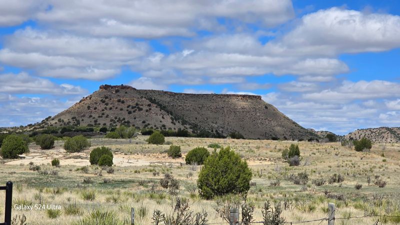
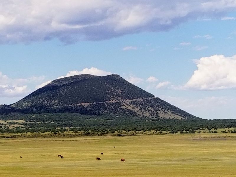
I stood at the base of Black Mesa, squinting up at the distant plateau that marks Oklahoma’s highest point, and wondered what I’d gotten myself into.
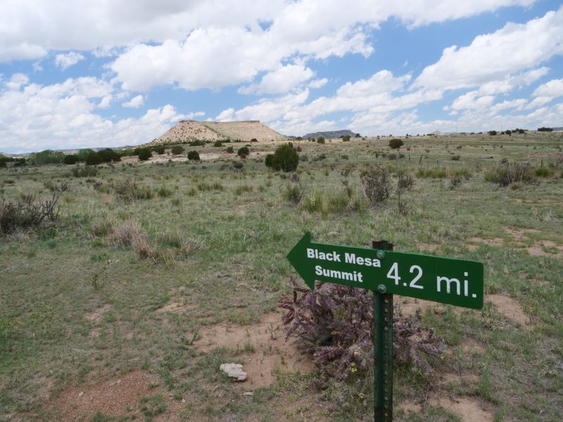
The trail stretched out before me like a ribbon across the high desert, promising an 8.4-mile round trip adventure to a place that feels like stepping into another world.
Located at Black Mesa Trail in Kenton, Oklahoma, this remote hiking area sits in the far northwestern corner of the state, where the landscape transforms from typical prairie into something altogether more dramatic.
The journey to 4,973 feet above sea level isn’t just about bagging a high point; it’s about experiencing a slice of Oklahoma that most people never knew existed, complete with bighorn sheep, sweeping vistas, and a solitude that’s increasingly hard to find.
The Journey Begins on an Ancient Road
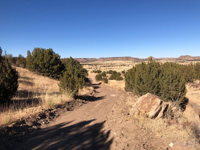
Walking the first stretch of this trail feels like traveling back in time along what used to be an old road. The path is wide and remarkably well-maintained, making those initial 2.5 miles surprisingly easy on your feet and legs.
I appreciated how the trail management has preserved this historic route while adding modern conveniences like covered benches at regular intervals.
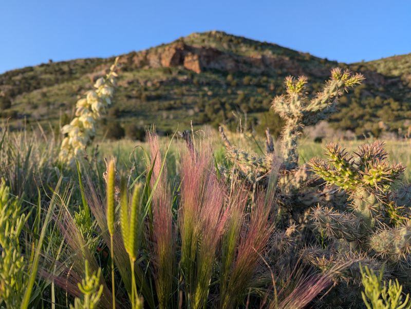
The flatness of this section might seem monotonous to some, but I found myself captivated by the changing vegetation and the way the mesa loomed larger with each step forward.
What struck me most was the openness of it all. There’s nowhere to hide from the elements out here, which means you’re fully immersed in the high desert environment from the moment you leave the trailhead.
The lack of shade along this portion requires some planning, especially during summer months when temperatures can soar. I learned quickly that starting early makes all the difference between a pleasant hike and a grueling ordeal.
Those covered benches I mentioned aren’t just nice touches; they’re strategic rest stops that even include emergency water supplies, though you shouldn’t count on them as your primary hydration source.
The Climb That Changes Everything
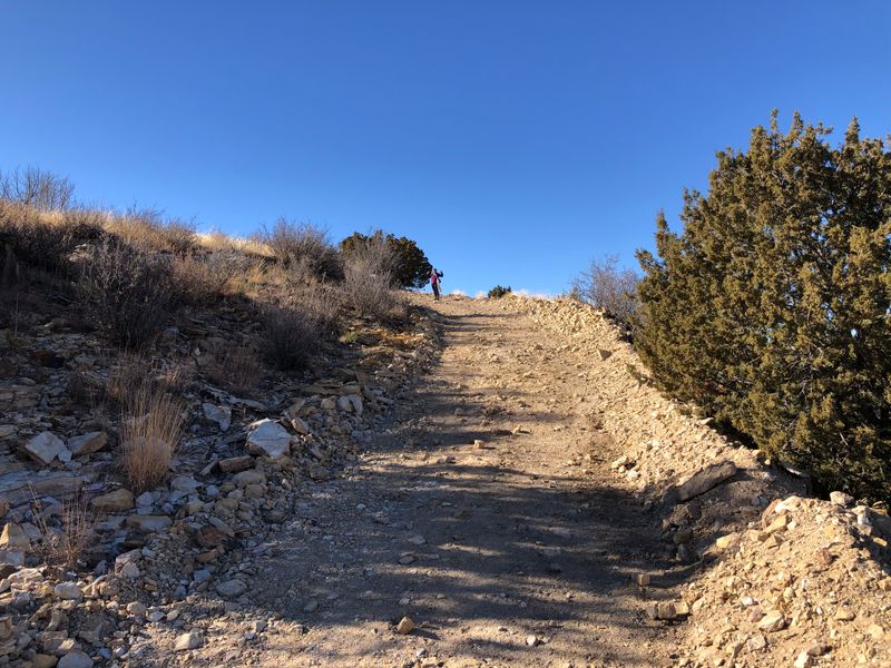
Around the 2.5-mile mark, the character of this hike transforms completely. The gentle stroll suddenly becomes a legitimate climb as the trail tackles a 500-foot elevation gain over just one mile.
My legs definitely felt the burn as I worked my way up the mesa’s face. The incline isn’t technical or dangerous, but it demands respect and a steady pace, especially if you’re not accustomed to high desert hiking.
I watched other hikers ahead of me zigzagging up the slope, some stopping frequently to catch their breath and admire the expanding view behind them. The perspective shifts dramatically with every hundred feet you gain, revealing more of the surrounding landscape.
What makes this climb manageable is the trail’s excellent condition. Even on the steepest sections, the path remains clear and stable underfoot, without the loose rocks or treacherous footing you might encounter on more rugged mountain trails.
By the time I crested the top of the mesa, my heart was pounding and my water bottle was significantly lighter. The transition from valley floor to mesa top feels like crossing into a different ecosystem entirely, with new plants and rock formations suddenly appearing.
Wildlife Encounters at the Summit
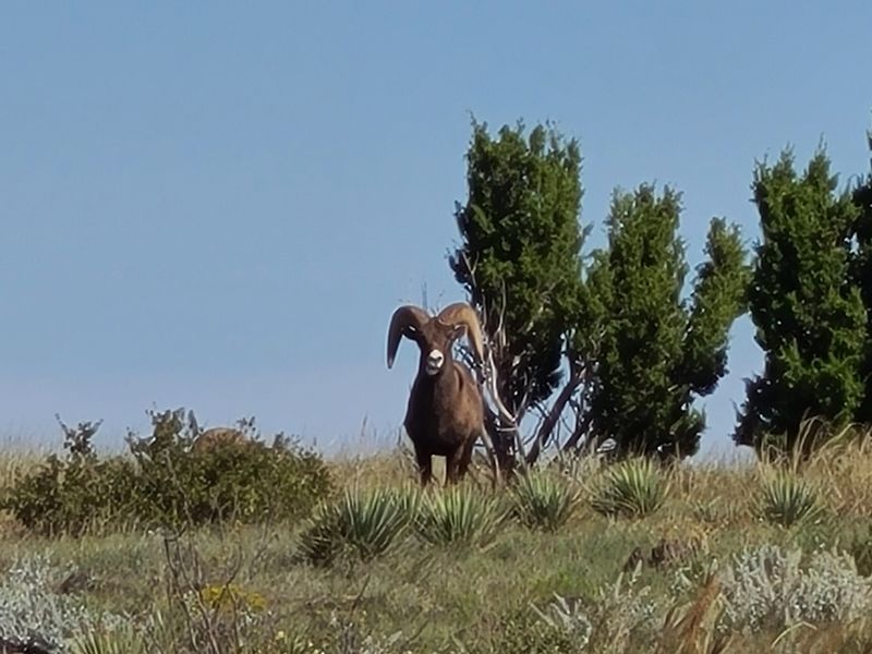
Reaching the top of the climb brought me an unexpected reward beyond the stunning views. Several hikers have reported spotting bighorn sheep right at the summit area, and I joined that lucky group during my visit.
The massive animals seemed completely unfazed by human presence, grazing calmly among the rocks and sparse vegetation. I kept a respectful distance, mesmerized by their sure-footedness on terrain that had challenged me considerably.
Beyond the sheep, the mesa supports a surprising variety of wildlife. Rabbits darted between bushes, and I spotted numerous birds riding the thermal currents that rise up the mesa’s face.
One reviewer mentioned encountering giant orange crickets, and I can confirm these unusual insects are everywhere once you reach the plateau. They’re harmless but certainly add to the otherworldly feeling of the place.
The wildlife diversity here reflects the unique ecological position of Black Mesa. This high elevation corner of Oklahoma creates habitat conditions more typical of New Mexico or Colorado than the rest of the state.
I recommend bringing binoculars if you’re interested in wildlife watching. The open terrain and elevated vantage point make this an excellent spot for observing animals in their natural environment without disturbing them.
The Final Mile Across the Mesa Top
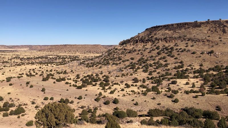
After conquering the steep ascent, the trail levels out dramatically for the final mile to the actual high point. This section offers a completely different hiking experience, crossing the relatively flat mesa top through grassland and low shrubs.
I found this portion meditative and peaceful. The hard work was behind me, and now I could simply enjoy the act of walking through this elevated landscape with views stretching in every direction.
The wind picks up considerably on the mesa top, and I quickly understood why several reviewers mentioned gusts of 30-40 mph. There’s nothing to block the air currents up here, and on my visit, the breeze was strong enough to lean into.
Despite the wind, the walking remains easy. The trail is clearly marked, and the monument marking Oklahoma’s highest point becomes visible in the distance, serving as a beacon to guide you forward.
This final stretch gave me time to reflect on the journey and appreciate the remoteness of this location. Looking around, I could see for miles in every direction, with barely a sign of human presence beyond the trail itself.
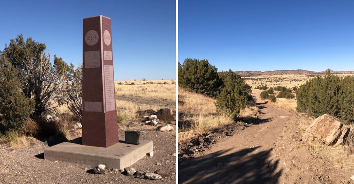
The Monument That Marks the Summit
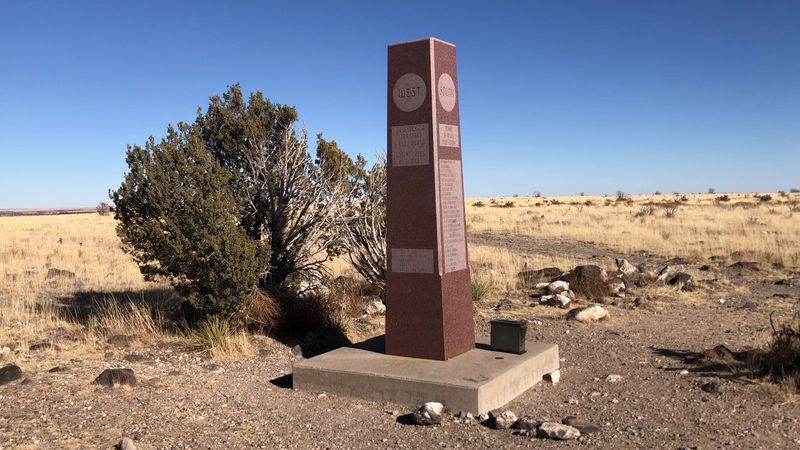
Standing before the stone obelisk that marks Oklahoma’s highest point, I felt a genuine sense of accomplishment. This monument has stood here for over 65 years, weathering countless storms while maintaining its dignity and purpose.
The structure itself is simple but impressive, a testament to the people who hauled materials up this mesa decades ago to create a permanent marker. I ran my hand along the stone, thinking about all the other hikers who’d made this same pilgrimage.
What surprised me was how well-maintained the monument remains despite its age and isolation. The inscription is still clearly legible, and the surrounding area is kept respectfully clear of debris.
Many hikers stop here for photos and a rest before heading back down. I watched as a family took turns posing with the monument, their faces showing the same mix of exhaustion and pride I was feeling.
The elevation here is 4,973 feet above sea level, which might not sound impressive compared to western mountain states, but represents something special for Oklahoma. This is as high as you can get in the entire state, and that makes it worth celebrating.
The Secret Overlook Beyond
Most hikers turn around at the monument, satisfied with reaching Oklahoma’s highest point. But I learned about a lesser-known trail that continues south from the marker to what locals call the overlook, and I’m glad I made the extra effort.
This unofficial path is small and easy to miss, but following it for just a few more minutes brings you to one of the most spectacular viewpoints I’ve encountered anywhere in Oklahoma. The edge of the mesa drops away dramatically, revealing layers of geology and vast expanses of high desert landscape.
Standing at this overlook, I could see into New Mexico and understand why this region feels so different from the rest of the state. The perspective is truly breathtaking, with nothing but wilderness stretching to the horizon.
The overlook adds roughly another half-mile to your total distance, bringing the complete hike to about 9.3 miles round trip. For me, this extra distance was absolutely worth it for the views alone.
I spent a solid 20 minutes just sitting at the edge, taking in the scenery and letting the magnitude of the landscape sink in. This is the kind of place that makes you feel simultaneously small and connected to something larger.
Timing Your Adventure Right
After completing this hike, I understood why timing matters so much for this particular trail. The trailhead is technically open 24 hours, but that doesn’t mean you should start at just any time of day.
Several experienced hikers recommended beginning before 7 AM, especially during warmer months, and I wholeheartedly agree with this advice. Starting early means you’re climbing the steep section before the sun reaches its peak intensity, making the experience far more pleasant.
I also learned about the importance of checking weather forecasts before heading out. One hiker’s story about being caught in a thunderstorm at the summit stuck with me because the mesa top is absolutely the last place you want to be when lightning starts.
The website suggests allowing at least four hours for the complete round trip, and I found this estimate accurate for someone with moderate fitness levels. Faster hikers might complete it in three hours, while those who stop frequently for photos or rest might need five or six.
Seasonal considerations matter too. Spring and fall offer the most comfortable temperatures, while summer can be brutally hot and winter occasionally brings snow to this high elevation area.
Water Strategy for Desert Hiking
Every single review I read before my hike mentioned water, and now I understand why this topic dominates the conversation. The high desert environment of Black Mesa is unforgiving when it comes to hydration needs.
I brought three liters of water for myself, and I finished nearly all of it during my hike. The combination of dry air, intense sun exposure, and physical exertion creates a perfect storm for dehydration if you’re not prepared.
The covered benches along the trail do have emergency water supplies, but multiple sources emphasize that you should never count on these as your primary hydration plan. They’re backups for emergencies, not drinking fountains for regular use.
I noticed the weight of my water supply significantly at the start of the hike, but I was grateful for every ounce by the time I reached the steep climbing section. Trying to tackle that elevation gain while dehydrated would be miserable and potentially dangerous.
For summer hiking, some veterans recommend carrying even more than three liters per person. The heat can be intense, and there’s absolutely no natural water source along the entire route.
Don’t forget about your hiking companions either, whether they’re human or canine. Dogs need plenty of water too, and the hot trail surface can be tough on their paws.
The Geological Wonder of Black Mesa
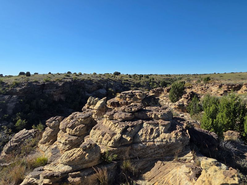
Beyond the achievement of reaching Oklahoma’s highest point, I found myself fascinated by the geology of Black Mesa itself. This formation represents something truly unique in the state’s landscape, a remnant of ancient processes that shaped the entire region.
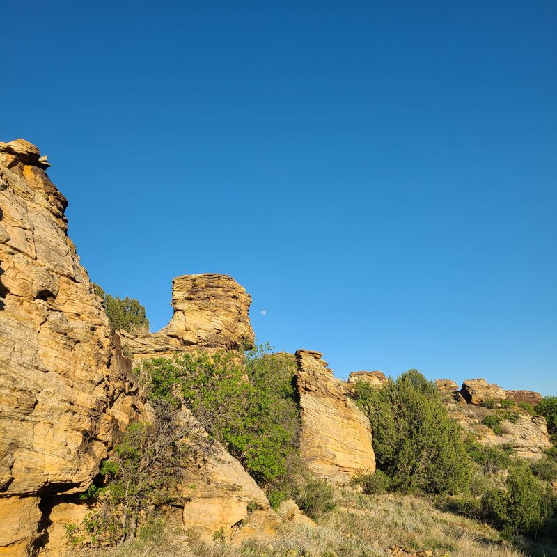
The mesa is capped by a resistant layer of rock that has protected it from erosion while the surrounding land wore away over millions of years. Walking across the top, I could see this protective layer clearly, with its distinctive dark color that gives Black Mesa its name.
Looking at the exposed cliff faces during my climb, I counted multiple layers of sedimentary rock, each one representing a different chapter in the area’s geological history. The colors ranged from deep reds to pale yellows, creating a natural artwork of stone.
This mesa is actually part of a larger formation that extends into New Mexico and Colorado. Standing at the Oklahoma section, I was looking at the easternmost reach of this geological feature, which makes the location even more special.
The rocks themselves tell stories of ancient seas, volcanic activity, and millions of years of wind and water sculpting the landscape into its current form. I wished I’d brought a geology guidebook to better understand everything I was seeing.
The View That Reaches Into New Mexico
One of the most remarkable aspects of reaching Black Mesa’s summit is realizing just how far you can see from this elevated vantage point. Looking westward from the monument, I could actually spot Capulin Volcano National Monument across the border in New Mexico.
The volcanic cone rises distinctly from the surrounding plains, and knowing I was looking at a feature in another state while standing at Oklahoma’s highest point gave me a profound sense of the landscape’s scale. This isn’t something you can experience in many places.
The clarity of the air at this elevation and in this dry climate means visibility extends for dozens of miles on a clear day. I could trace the contours of distant mesas and mountains, each one adding depth to the panoramic scene.
This cross-state view reminded me that geographical and political boundaries are human constructs. The landscape doesn’t recognize state lines; it flows continuously across the high plains, shaped by forces that operated long before any borders were drawn.
I spent considerable time just scanning the horizon, trying to identify distant landmarks and appreciating the sheer expanse of wilderness visible from this single point. It’s a perspective that makes you reconsider the scale of the American West.
Solitude in Oklahoma’s Most Remote Corner
What struck me most powerfully during my Black Mesa hike was the profound solitude available in this far corner of Oklahoma. Kenton sits in the state’s panhandle, about as far from major population centers as you can get, and that remoteness translates into a hiking experience unlike anything else in Oklahoma.
During my entire trek, I encountered only a handful of other hikers. The trail never felt crowded or busy, and there were long stretches where I was completely alone with the landscape, the wind, and my thoughts.
This solitude isn’t for everyone. Some people find such isolation uncomfortable or even anxiety-inducing.
But for me, it was exactly what I needed, a chance to disconnect from the constant noise of modern life and reconnect with something more fundamental.
The remoteness does require extra preparation and caution. Cell phone service is unreliable at best, and if something goes wrong, help is far away.
But with proper planning, this isolation becomes a feature rather than a concern.
I found the solitude contemplative and restorative. Walking alone across the mesa top, I understood why one reviewer described this as a perfect solo trek, a journey that allows for genuine introspection and connection with the natural world.
Dear Reader: This page may contain affiliate links which may earn a commission if you click through and make a purchase. Our independent journalism is not influenced by any advertiser or commercial initiative unless it is clearly marked as sponsored content. As travel products change, please be sure to reconfirm all details and stay up to date with current events to ensure a safe and successful trip.