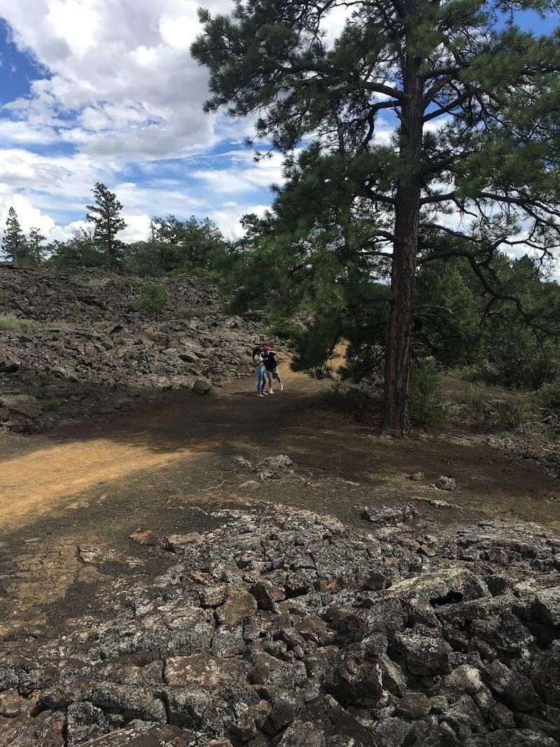
I have stood on some pretty dramatic landscapes before, but nothing prepared me for this scene in New Mexico. Walking onto a field of sharp, jagged black rock that stretches as far as I could see felt less like hiking and more like stepping onto another planet. The silence was the weirdest part.
No birds, no wind through trees. Just this massive, frozen wave of lava that erupted thousands of years ago and then just stopped.
You look around and realize how tiny you actually are. It is humbling in a strange way.
And honestly, a little intimidating. My legs hurt from climbing over all those cracks, but I could not stop smiling.
The Lava Fields That Look Like a Frozen Ocean
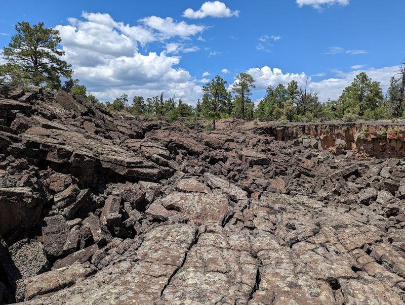
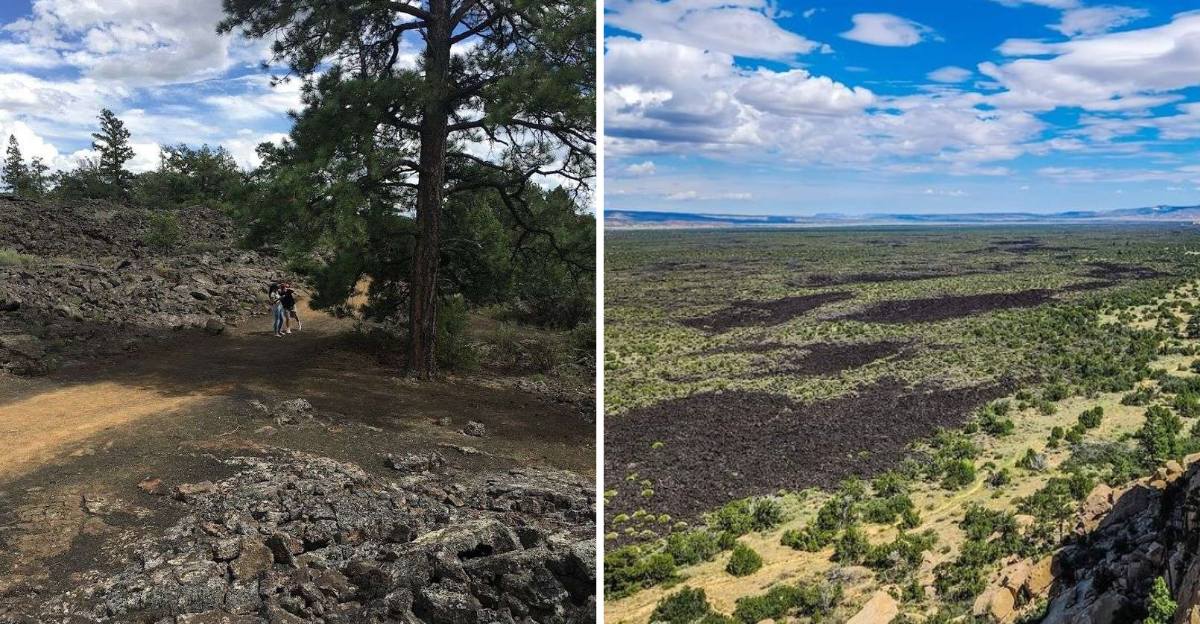
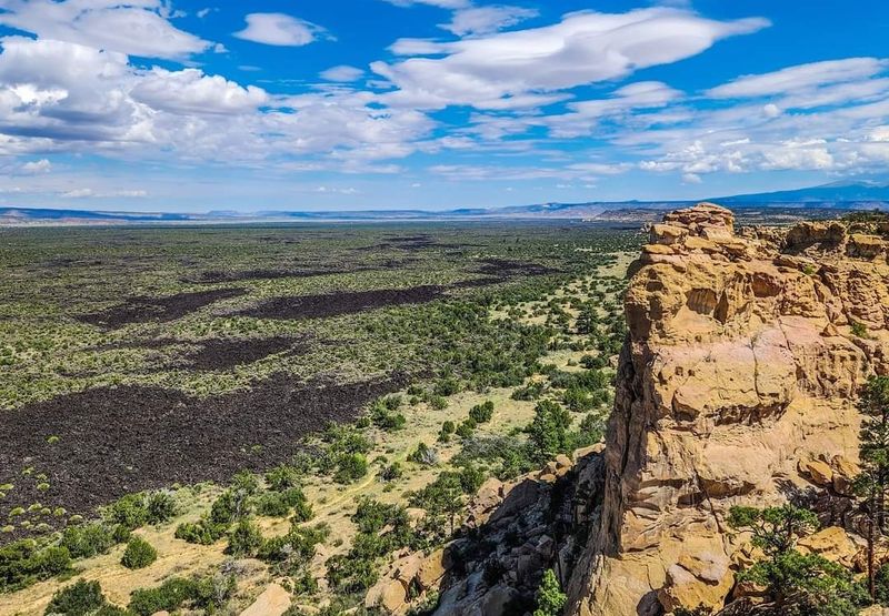
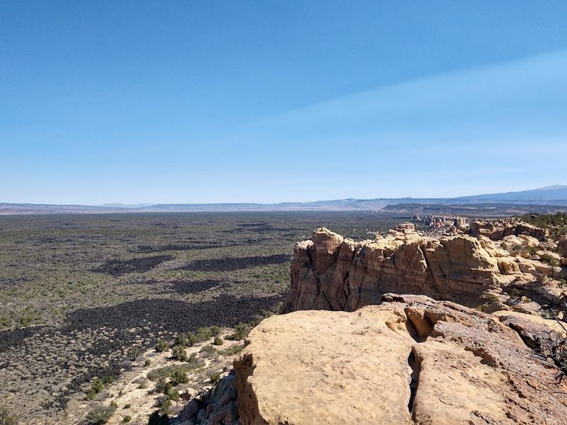
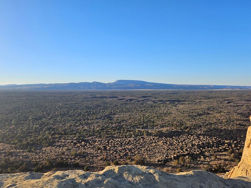
The first glimpse of the lava fields at El Malpais genuinely made me do a double-take. The rock stretches out in every direction, folded and twisted like someone paused a massive wave mid-crash and let it cool forever.
It is disorienting in the best possible way.
These lava flows are the result of volcanic activity that began around 115,000 years ago and continued until roughly 3,000 years ago. The most recent flows are surprisingly young in geological terms, which explains why the surface still looks so raw and unsettled.
Some sections ripple in smooth, rope-like patterns called pahoehoe, while others crack into sharp, jagged chunks called aa lava.
Walking across them requires full attention because the surface is uneven and unpredictable. The rock absorbs heat from the sun and radiates it back intensely on warm days.
You can hear the wind move through the cracks and crevices in a low, almost musical hum. Geologists consider this one of the most intact and accessible lava fields in North America.
The sheer scale of it, miles and miles of black rock, really does make the world feel enormous and ancient.
Bandera Volcano and Its Surprisingly Deep Crater
Bandera Volcano does not look like the volcanoes you see in textbooks. There is no dramatic mountain peak here, just a broad, steep-sided cinder cone that rises from the surrounding lava field like a rough crown of dark rock.
Its crater drops about 800 feet deep, which is a measurement that sounds manageable until you are actually standing near the rim.
The volcano last erupted roughly 10,000 years ago, and the evidence is everywhere. The cinder cone itself is made of fragmented lava pieces called scoria, and the slopes feel almost spongy underfoot because the material is so light and porous.
It is one of the most accessible cinder cone examples in North America, which makes it genuinely valuable for anyone even mildly curious about geology.
From the top of the trail near the cone, the view across the lava field is staggering. The scale of destruction and creation that one eruption produced is hard to fully absorb.
Bandera also produced a 23-mile-long lava flow, one of the longest in the contiguous United States. That single statistic tends to land differently once you have seen the landscape with your own eyes.
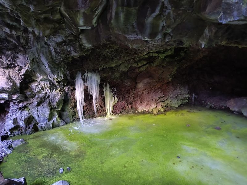
The Ice Cave That Defies the Desert Heat
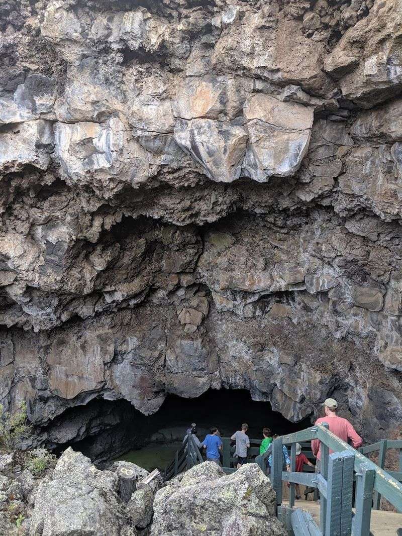
An ice cave sitting in the middle of a desert sounds like a trick, but the Bandera Volcano Ice Cave is completely real and honestly one of the strangest things I have ever seen. The cave sits inside a collapsed lava tube, and its structure creates a natural refrigeration effect that keeps temperatures below freezing every single day of the year.
Cold air sinks into the cave through its opening and gets trapped by the porous lava walls, which insulate the interior like a giant cooler. Rainwater and snowmelt seep in and freeze on the floor, building up ice that is now estimated to be up to 20 feet thick in some places.
The ice has been accumulating for over 3,400 years, which means some of it predates the Roman Empire.
What makes it even more visually striking is the layer of Arctic algae growing on the surface of the ice. It creates a blue-green shimmer that looks almost otherworldly against the dark rock walls.
The cave maintains this frozen state even during New Mexico’s hottest summers. Stepping into that cool, dim space after hiking across sun-baked lava feels like a reward that the landscape saved just for you.
La Ventana Natural Arch and the Sandstone Cliffs
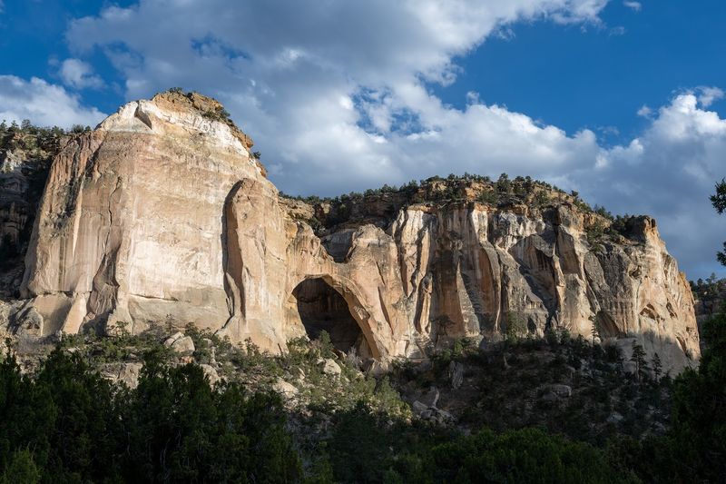
Not everything at El Malpais is black rock and volcanic rubble. La Ventana Natural Arch is one of the largest natural arches in New Mexico, and it sits tucked against a sweeping sandstone bluff that glows warm orange and red in afternoon light.
The contrast between the pale stone and the dark lava nearby is genuinely beautiful.
The arch is visible from a short, easy trail that winds along the base of the cliffs. You round a bend, and there it is, a massive opening in the rock that frames a perfect rectangle of sky.
It has the kind of presence that makes you stop talking mid-sentence and just look. The sandstone here was formed long before the volcanic activity, which means the arch and the lava fields are telling two completely different chapters of the same geological story.
Early morning visits tend to offer the best light for appreciating the arch’s color and texture. The cliff faces around it are layered in bands of different stone, each representing thousands of years of sediment.
Swallows often nest in the crevices above, darting in and out with quick, precise movements. It is a quieter, gentler side of El Malpais that feels like a welcome exhale after the intensity of the lava fields.
The Lava Tube System Hidden Beneath the Surface
Underneath the surface of the lava fields, a network of hollow tunnels runs for miles in the dark. These are lava tubes, and they formed when the outer shell of a flowing lava river cooled and hardened while molten rock continued moving inside.
Eventually the inner lava drained away, leaving long, cave-like passages behind.
El Malpais contains one of the longest known lava tube systems in North America. Some sections are large enough to walk through comfortably, while others narrow to tight squeezes that require real effort.
Exploring them requires a headlamp, sturdy footwear, and a willingness to trust your feet on uneven, sometimes slippery rock. The National Park Service provides basic guidance on which tubes are open to the public.
Inside, the temperature drops noticeably, and the silence is almost complete. The walls are smooth in some places and sharply textured in others, showing exactly where the lava moved fastest or slowest.
Mineral deposits catch your light and glint unexpectedly. There is something quietly thrilling about standing in a channel carved entirely by flowing rock.
These tubes are a reminder that the landscape above ground is only part of what El Malpais has to offer.
Ancient Zuni-Acoma Trail Across the Lava
Long before there were paved roads or trail signs, Indigenous people were crossing this lava field on foot. The Zuni-Acoma Trail is one of the oldest trade routes in the region, used for centuries by the Zuni and Acoma Pueblo people to travel between their communities.
The trail covers about seven and a half miles across the lava, and sections of the original path are still intact.
Hiking it today means following a route that generations of people walked carrying goods, stories, and knowledge between their nations. The lava underfoot is the same lava they navigated, rough, unforgiving, and deeply familiar to those who knew it well.
Rock cairns mark the way, just as they have for hundreds of years, guiding travelers across a surface that offers very few natural landmarks.
The trail is considered challenging and should not be attempted without proper preparation. Sun exposure is intense, water sources are nonexistent, and the terrain demands constant attention.
But the experience of walking a living historical route through such a striking landscape carries a weight that is hard to describe. Every step connects you to something much older than the monuments and markers we usually use to remember the past.
It is one of the most meaningful hikes in the entire Southwest.
Wildlife That Somehow Thrives in the Lava
You might assume that a landscape made of hardened volcanic rock would be nearly lifeless, but El Malpais surprises you. Animals have found ways to carve out existence in and around the lava fields, and spotting them adds an unexpected layer of wonder to any visit.
Mule deer pick their way along the edges of the flows with a calm that suggests they have done this their entire lives.
Pronghorn antelope graze in the grassy patches between lava outcroppings. Ravens patrol the skies overhead, their calls echoing off the rock in ways that feel almost theatrical.
Coyotes are often heard at dusk, their yipping carrying far across the flat, open terrain. Smaller creatures like lizards and rodents make use of the crevices and caves scattered throughout the lava for shelter and shade.
Pinon jays flock through the juniper and pinon pine trees that manage to grow in soil pockets among the rocks. Ponderosa pines appear at higher elevations, offering habitat for additional bird species.
The biodiversity here is modest compared to lusher environments, but every creature you encounter feels like a small triumph of adaptation. Watching life persist in such an extreme landscape has a way of shifting your perspective on what resilience actually looks like.
Planning Your Visit to El Malpais National Monument
Getting to El Malpais is straightforward. The monument sits near Grants, New Mexico, along Highway 53 and Highway 117, both of which offer scenic drives with pullouts and short trails.
The visitor center on East Santa Fe Avenue in Grants is a great first stop for maps, trail conditions, and ranger advice before heading out into the monument.
The best times to visit are spring and fall, when temperatures are comfortable for hiking and the light is especially beautiful in the mornings and evenings. Summer visits are possible but require extra water, sun protection, and an early start to avoid the midday heat that radiates intensely off the dark lava.
Winter brings its own rewards, including occasional snow that settles into the crevices and turns the black rock into something almost painterly.
There is no entrance fee for El Malpais, which makes it one of the most accessible national monuments in the country. Camping is available in designated areas, and the monument is large enough that a single day barely scratches the surface of what is here.
Give yourself at least a full day, ideally two, to absorb the lava fields, the caves, the arch, and the trails at a pace that lets the place actually settle in. Address: 1900 E.
Santa Fe Ave., Grants, NM 87020.
Dear Reader: This page may contain affiliate links which may earn a commission if you click through and make a purchase. Our independent journalism is not influenced by any advertiser or commercial initiative unless it is clearly marked as sponsored content. As travel products change, please be sure to reconfirm all details and stay up to date with current events to ensure a safe and successful trip.