I’ve trekked a lot of trails, but nothing prepared me for the magic tucked away in New Jersey’s highlands.
The Delaware Water Gap National Recreation Area hides a path that feels like stepping straight into a wilderness fairy tale.
One minute you’re following rushing waterfalls, the next you’re winding through ancient forests, and before you know it – you’re standing beside a pristine glacial lake perched high above the Delaware River.
Spring here is pure enchantment. Mountain laurel explodes in bloom, creeks roar with snowmelt, and rhododendron tunnels arch overhead like natural cathedrals.
Hiking from Dunnfield Creek to Sunfish Pond isn’t just a workout; it’s a journey through geological time, guided by the legendary white blazes of the Appalachian Trail.
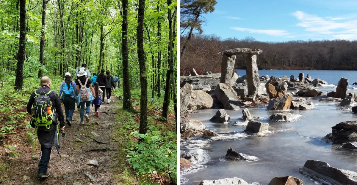
I’ll never forget the feeling of standing beside that 44-acre lake, stacked cairns rising like mystical markers all around. Or the cool hush of a hemlock ravine so dense that sunlight barely touches the forest floor.
It’s the kind of hike that makes you feel small in the best possible way.
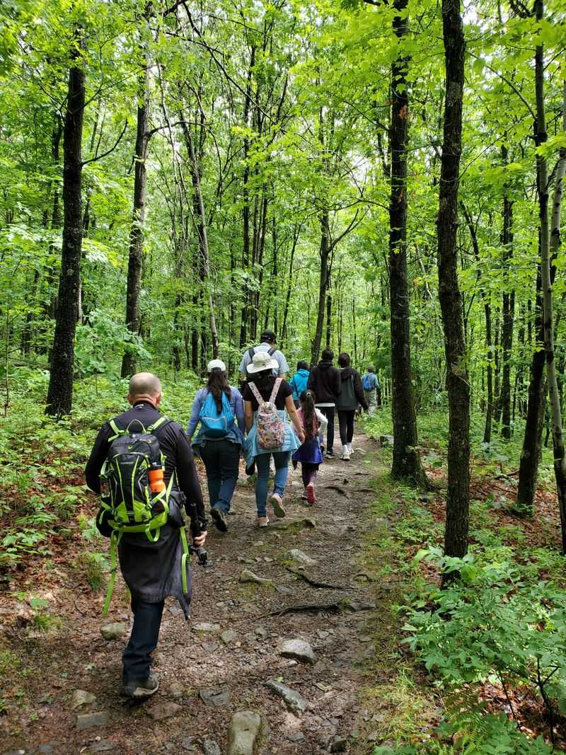
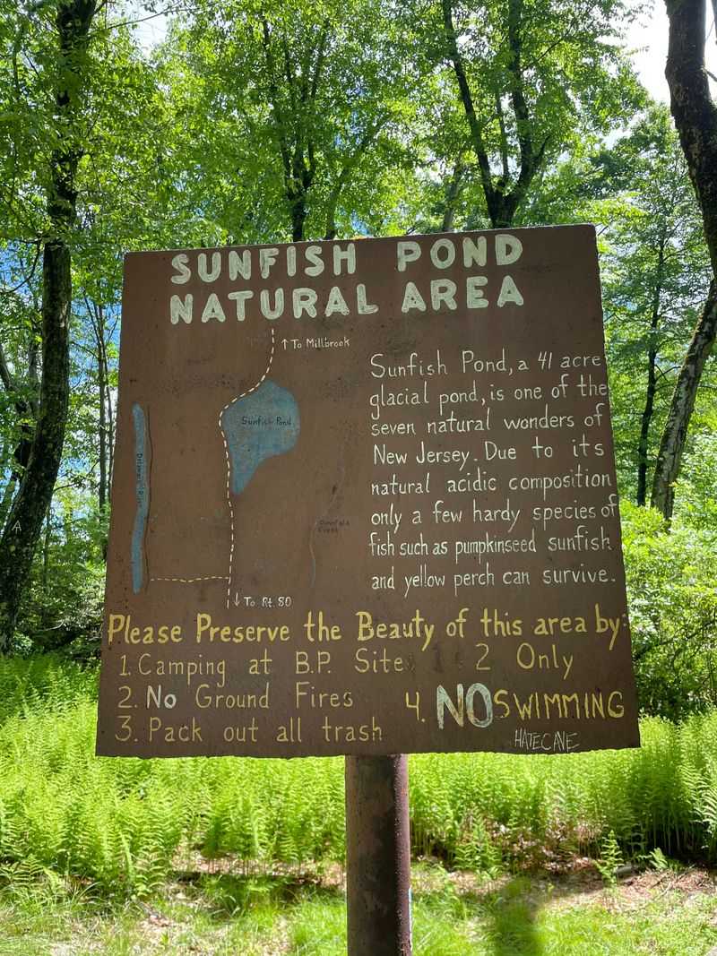
Dunnfield Creek Trailhead Parking
Anticipation builds the moment you pull into the Dunnfield Creek Trailhead parking area off Old Mine Road in Columbia, New Jersey. Nestled at the base of Mount Tammany, this gateway to adventure sits within the Delaware Water Gap National Recreation Area, where the mighty Delaware River has carved a stunning passage through the Kittatinny Ridge over millions of years.
Your vehicle joins dozens of others belonging to fellow adventurers, all drawn to this legendary starting point where multiple trails converge and possibilities multiply.
Spring mornings here carry a special magic. Mist rises from the nearby creek while birdsong fills the air, and the parking lot buzzes with the excited chatter of hikers checking their packs one last time.
Information boards display trail maps and safety reminders, helping you orient yourself before the journey begins. The lot fills quickly on weekends, so arriving early gives you both a parking spot and the gift of cooler temperatures for the climb ahead.
Rangers patrol regularly, ensuring everyone knows the rules and respects this protected landscape. You’ll notice the well-maintained facilities including restrooms and clear trail markers pointing toward multiple destinations.
Mount Tammany looms directly above, its rocky face a constant reminder of the elevation you’re about to gain. The energy here is contagious as backpackers adjust their gear, families apply sunscreen, and solo hikers lace up their boots with determined expressions.
This trailhead represents more than just a parking spot. It’s the threshold between everyday life and wilderness adventure, where pavement ends and dirt paths begin.
Every journey to Sunfish Pond starts right here, where anticipation meets preparation and the highlands call your name with irresistible urgency.
Dunnfield Creek
Within moments of leaving the parking area, you’re walking alongside Dunnfield Creek, and the transformation is immediate. This protected trout stream tumbles down from the highlands above, its waters so clear you can count every pebble on the streambed below.
Mossy rocks line the banks, their emerald surfaces glistening with moisture from the constant spray of rushing water. The creek’s voice becomes your hiking companion, a soothing soundtrack that drowns out any lingering thoughts of the world you’ve left behind.
Springtime turns Dunnfield Creek into a roaring spectacle. Snowmelt from higher elevations swells the waterway, sending torrents cascading over boulders and creating miniature rapids that splash and foam with wild energy.
Trout dart through the deeper pools, their spotted backs flashing briefly before disappearing into the shadows beneath overhanging banks. Protected status means these fish thrive here, and if you pause quietly on a footbridge, you might spot several hovering against the current.
The trail hugs the creek’s eastern bank, occasionally crossing wooden footbridges that offer perfect vantage points for photographs. Mountain laurel bushes crowd the water’s edge, their twisted branches creating natural frames for the rushing water beyond.
The air feels noticeably cooler here, refreshed by the constant movement of water and the shade from towering hemlocks that block the harshest sunlight.
Local legend says Native Americans fished these waters for centuries before European settlers arrived. Whether historically verified or not, the creek certainly feels ancient and timeless, its course carved deep into bedrock over countless millennia.
Every step alongside Dunnfield Creek reinforces why this hike ranks among New Jersey’s finest wilderness experiences.
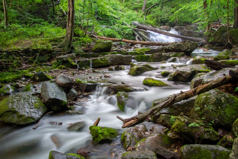
Dunnfield Falls
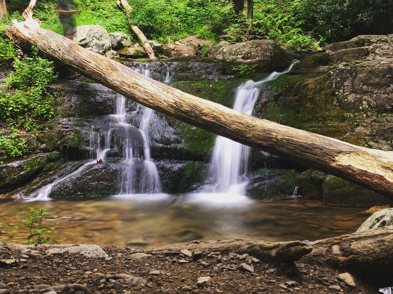
Roughly a half mile from the trailhead, Dunnfield Falls announces itself with a crescendo of rushing water that echoes through the forest. This picturesque cascade tumbles over a series of rocky ledges, creating a multi-tiered waterfall that photographers absolutely adore.
Google Maps reviews consistently mention this spot as a highlight, and once you round the bend and see it for yourself, you’ll understand why. The falls drop about 40 feet in total, with water sheeting over smooth rock faces polished by centuries of flow.
Springtime amplifies the falls’ drama exponentially. High water volumes send spray billowing outward, creating a misty veil that catches sunlight and occasionally produces fleeting rainbows.
The roar becomes almost deafening as you approach the viewing area, where flat rocks provide natural seating for those who want to linger. Ferns cluster around the base, their fronds unfurling in the constant moisture, while rhododendrons frame the scene with glossy green leaves that will burst into bloom by early summer.
Photographers set up tripods here at all hours, chasing the perfect combination of light and water movement. The falls face northeast, meaning morning light illuminates them beautifully while afternoon visits offer cooler, shadier conditions.
A small spur trail leads to the base, though caution is necessary since wet rocks become treacherously slippery. Most hikers content themselves with the main viewing area, which offers excellent sightlines without the risk.
This waterfall represents just a preview of the natural wonders ahead. Yet many visitors admit that Dunnfield Falls alone justifies the hike, serving as a spectacular reward for minimal effort.
The memory of its thundering beauty stays with you as the trail continues upward into the highlands.
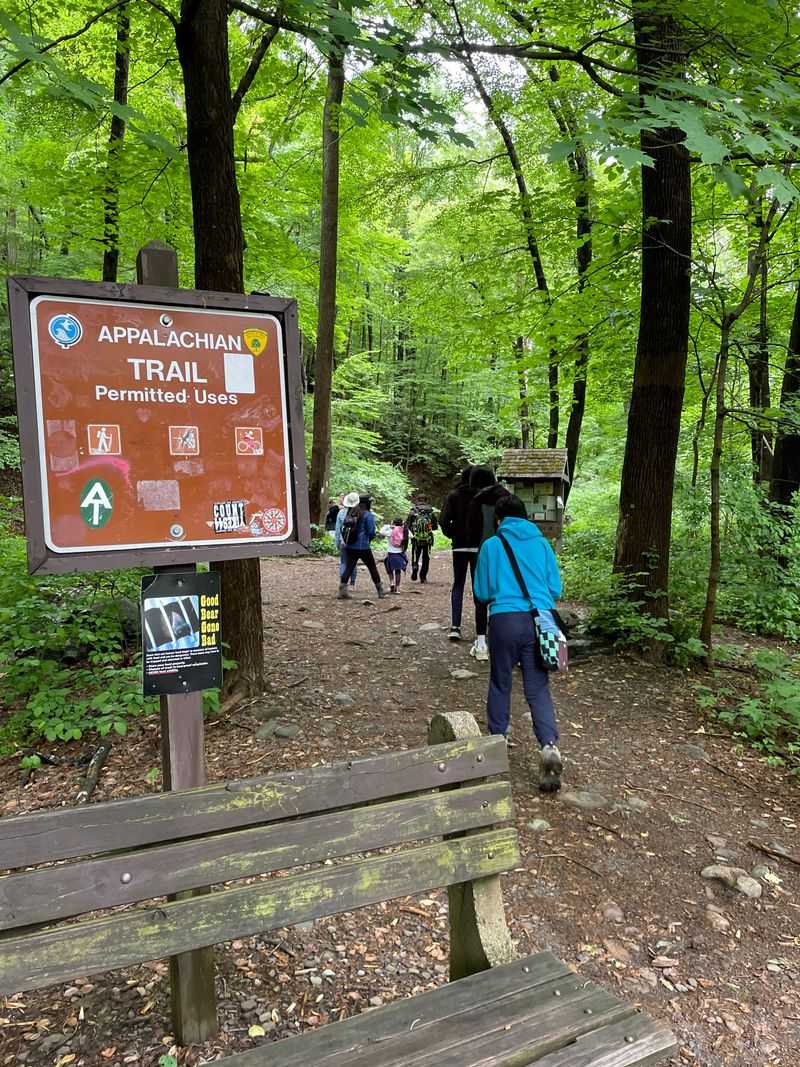
Appalachian Trail Junction
Beyond the falls, the trail begins its serious work, and suddenly you’re standing at one of the most famous intersections in American hiking. White rectangular blazes appear on trees, marking your merger with the legendary Appalachian Trail that stretches 2,190 miles from Georgia to Maine.
For thru-hikers attempting the entire AT, this New Jersey section represents a crucial milestone, while for day hikers like yourself, it offers a taste of what makes this footpath so iconic. The transition is marked by a trail register where you can sign in and read messages from previous adventurers.
The terrain shifts immediately once you join the AT. Gentle creek-side walking gives way to rocky switchbacks that demand attention with every step.
Roots crisscross the path like natural staircases, and boulders require occasional scrambling using both hands and feet. Your heart rate climbs along with the elevation, and the forest composition changes as you ascend from the creek valley into drier upland zones.
Oaks and hickories begin replacing the moisture-loving hemlocks below.
Trail maintenance is exceptional here thanks to dedicated volunteer crews who clear blowdowns, repair erosion, and keep those white blazes freshly painted. You’ll pass rock cairns at confusing junctions, each one carefully constructed to guide hikers in the right direction.
The AT’s reputation for being well-marked proves accurate, though occasional side trails to viewpoints can create momentary confusion for the unwary.
Joining the Appalachian Trail feels like entering an exclusive club with millions of members spanning decades. The path beneath your boots has been walked by countless dreamers, adventurers, and seekers of solitude.
Now you’re part of that tradition, following white blazes toward a glacial lake that awaits in the highlands above.
The Hemlock Ravine
Climbing steadily now, you enter what locals call the Hemlock Ravine, and the temperature drops noticeably within seconds. Towering eastern hemlocks create a dense evergreen canopy that blocks direct sunlight even on the brightest spring days.
Their drooping branches form a natural cathedral, and the air beneath feels cooler, damper, and somehow more ancient than the mixed hardwood forests you’ve passed through. Dunnfield Creek still rushes somewhere below, though the sound grows fainter as elevation separates you from the waterway.
These hemlocks represent survivors of a massive forest that once covered much of the northeastern United States. Their thick bark and dense foliage create microclimates that support specialized plants and animals found nowhere else.
Moss carpets every surface, from fallen logs to exposed rocks, creating a verdant tapestry that seems to glow with an inner light. The filtered sunshine creates dappled patterns on the trail, constantly shifting as breezes sway the branches overhead.
Scientists worry about hemlock woolly adelgid, an invasive insect threatening these magnificent trees throughout their range. So far, this ravine shows minimal damage, but rangers monitor closely and treat affected trees when possible.
Walking through this shaded sanctuary, you gain deep appreciation for conservation efforts protecting such irreplaceable ecosystems. The coolness provides welcome relief during warmer months, making this section particularly pleasant when summer heat bakes the exposed ridges above.
Bird calls echo differently here, muffled by the dense needles yet somehow amplified by the ravine’s acoustics. Hermit thrushes and winter wrens favor these hemlock groves, their melodious songs adding soundtrack to your passage.
The ravine extends for nearly a mile, offering sustained shade before the trail eventually climbs beyond the hemlocks’ preferred elevation range.
Mount Tammany Fire Road Intersection
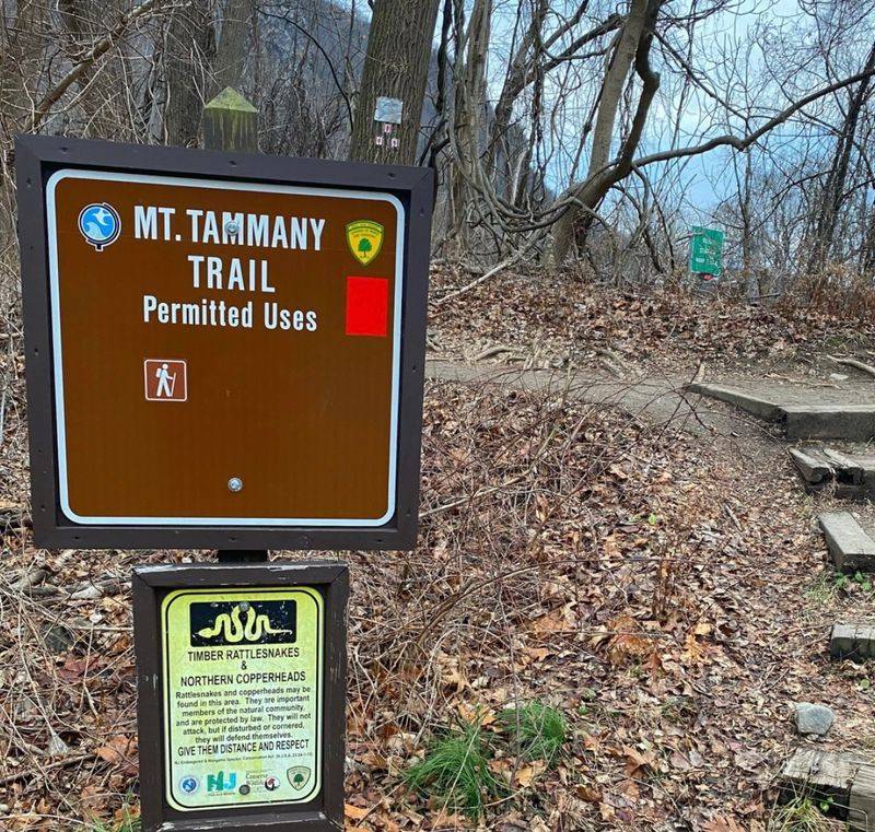
Breathing hard now, you reach a significant crossroads where the Appalachian Trail intersects with the Mount Tammany Fire Road. Trail signs point in multiple directions, each promising different adventures and challenges.
Mount Tammany’s summit lies to your left, reachable via a brutally steep climb that rewards with panoramic views of the Delaware Water Gap. Your destination, Sunfish Pond, requires bearing right and continuing the steady but less punishing ascent along the AT.
Most hikers pause here, consulting maps and catching their breath before committing to their chosen route.
The fire road itself is a wide, graded path that maintenance vehicles use to access remote sections of Worthington State Forest. Its relatively flat surface provides a brief respite from the rocky, root-crossed trail you’ve been navigating.
Some hikers choose to descend via this fire road later, creating a loop that avoids retracing their steps. The intersection sits in a saddle between peaks, offering glimpses through the trees of the ridges surrounding you on multiple sides.
Springtime brings wildflowers to the sunnier edges of this clearing. Trillium, bloodroot, and wild geraniums bloom in succession as the season progresses, their delicate petals adding splashes of color to the predominantly green landscape.
Butterflies visit these flowers, and if you’re lucky, you might spot a black swallowtail or tiger swallowtail nectaring on the blooms. The increased sunlight also attracts snakes, particularly harmless garter snakes and occasionally timber rattlesnakes, so watch your footing.
Decision time weighs heavy here for some hikers. The summit of Mount Tammany tempts with its famous views, but Sunfish Pond calls with the promise of glacial waters and unique geology.
Most choose the pond, saving Tammany for another day when fresh legs can tackle that relentless climb with proper enthusiasm.
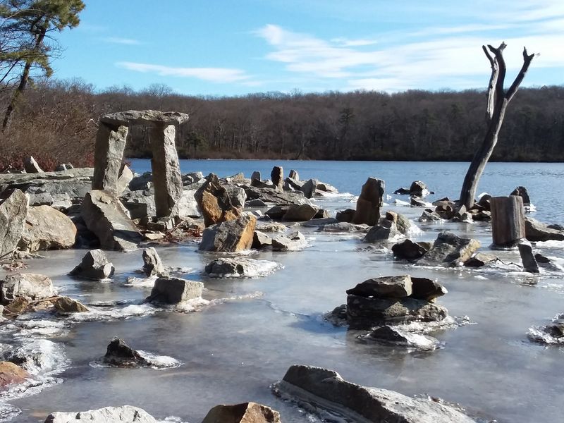
The Rock Cairn Field
Something magical happens as you continue past the fire road intersection. The trail enters what hikers have dubbed the Rock Cairn Field, a unique section where thousands upon thousands of river stones have been stacked into precarious towers by passing adventurers.
Some cairns stand barely a foot tall, while others reach waist height or beyond, defying gravity with their improbable balance. The effect is simultaneously mystical and whimsical, transforming an ordinary stretch of trail into an outdoor art gallery created by countless anonymous artists.
Nobody knows exactly when this tradition began, but it’s clearly been building for years. Each hiker who passes feels compelled either to add their own cairn or contribute a stone to an existing tower.
The practice technically violates Leave No Trace principles, yet the phenomenon has become so established that removing the cairns would seem like destroying a beloved landmark. Park officials have adopted a tolerant stance, neither encouraging nor actively discouraging the practice, recognizing that the cairns have become part of this trail’s unique character.
Photographing the cairn field presents delightful challenges. Morning and evening light create long shadows that emphasize the towers’ height and precarious balance.
Some hikers spend considerable time here, carefully stacking their own contributions and testing different rock combinations for maximum stability. The meditative quality of rock balancing appeals to many, offering a mindful break from the physical demands of hiking.
Skeptics dismiss the cairns as unnecessary trail clutter, arguing that natural landscapes need no human embellishment. Yet supporters counter that the field represents communal creativity and the universal human impulse to leave marks of passage.
Whatever your perspective, walking through this forest of stone towers creates an unforgettable experience that distinguishes this hike from countless others in the region.
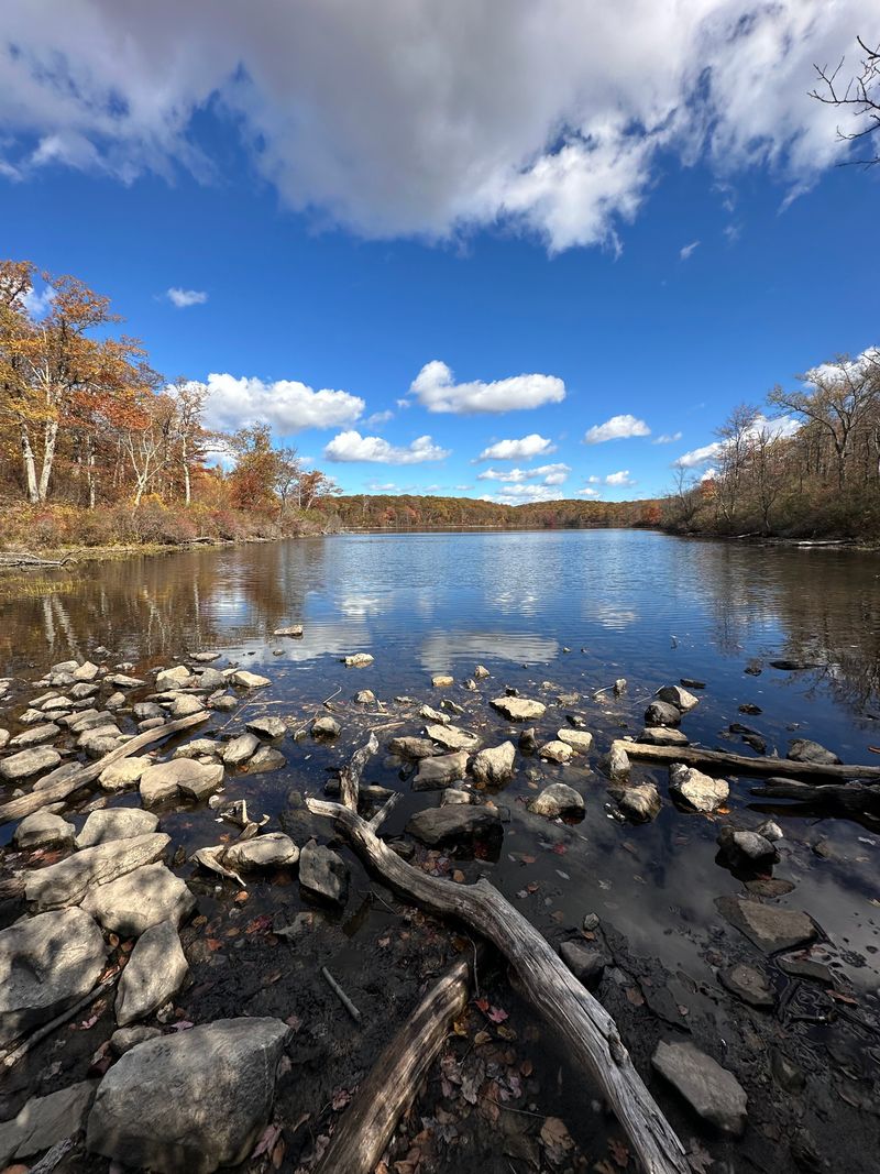
Sunfish Pond Southern Shore
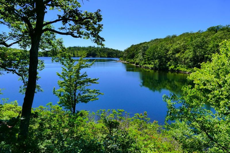
Then it happens. After hours of climbing through forests and ravines, the trees suddenly part and Sunfish Pond reveals itself in all its glacial glory.
This 44-acre natural wonder sits perched roughly 1,000 feet above the Delaware River, a National Natural Landmark that represents one of the finest examples of a glacial lake in the entire Mid-Atlantic region. The southern shore where you emerge offers the first breathtaking views, with crystal-clear waters stretching northward and reflecting the sky like a massive mirror dropped into the highlands.
The pond’s origins trace back approximately 15,000 years to the retreat of the last ice age. Massive glaciers carved this basin into the bedrock, and when they melted, the depression filled with water that has remained remarkably pristine ever since.
No motorized boats disturb these waters, no development mars the shoreline, and strict regulations protect the pond from the pollution that has degraded so many other water bodies. Swimming is prohibited to preserve water quality, though on hot days the temptation to dive in becomes almost overwhelming.
Springtime brings the pond alive with activity. Frogs chorus from the shallows, their breeding calls echoing across the water.
Dragonflies patrol the shoreline, hunting smaller insects with aerial precision. The surrounding forest reflects in the still surface, creating perfect mirror images that confuse perspective and make photographers giddy with possibilities.
Mountain laurel bushes crowd the water’s edge, their buds swelling with the promise of June blooms that will transform the shoreline into a floral spectacle.
Many hikers simply collapse on the rocks here, overcome by the beauty and exhausted from the climb. The pond’s tranquil atmosphere invites extended rest, and indeed, this makes an ideal lunch spot where you can refuel while soaking in views that seem impossibly pristine for anywhere in densely populated New Jersey.
Worthington State Forest Glacial Boulders
Walking along Sunfish Pond’s perimeter trail, you encounter some of the most impressive geological features in all of New Jersey. Massive boulders, known as glacial erratics, lie scattered around the shoreline like toys abandoned by giant children.
These enormous rocks, some the size of small houses, were plucked from distant locations by advancing glaciers and deposited here when the ice finally retreated. Their composition often differs from the local bedrock, proving they traveled many miles locked within the glacier’s frozen grip before being released.
The largest erratics display distinctive scratch marks called glacial striations, parallel grooves carved by smaller rocks embedded in the glacier’s base as it ground across the landscape. Running your fingers along these ancient scratches connects you directly to events that occurred during the Pleistocene epoch, when woolly mammoths and saber-toothed cats roamed what would eventually become the Garden State.
Geologists study these boulders extensively, using them to reconstruct glacier movements and understand past climate conditions.
Lichens paint the boulder surfaces in abstract patterns of orange, green, and gray. These hardy organisms represent some of Earth’s oldest life forms, partnerships between fungi and algae that can survive on bare rock where nothing else can gain purchase.
Some lichen colonies here may be centuries old, growing at rates measured in millimeters per decade. Moss fills cracks and crevices, softening the rocks’ harsh angles and creating miniature gardens in unlikely places.
Kids love scrambling over these boulders, and adults find them irresistible too, offering natural jungle gyms and photo opportunities. The largest erratics provide elevated platforms for viewing the pond from different perspectives.
Sitting atop one of these ancient travelers, you gain a visceral sense of the immense forces that shaped this landscape millennia ago.
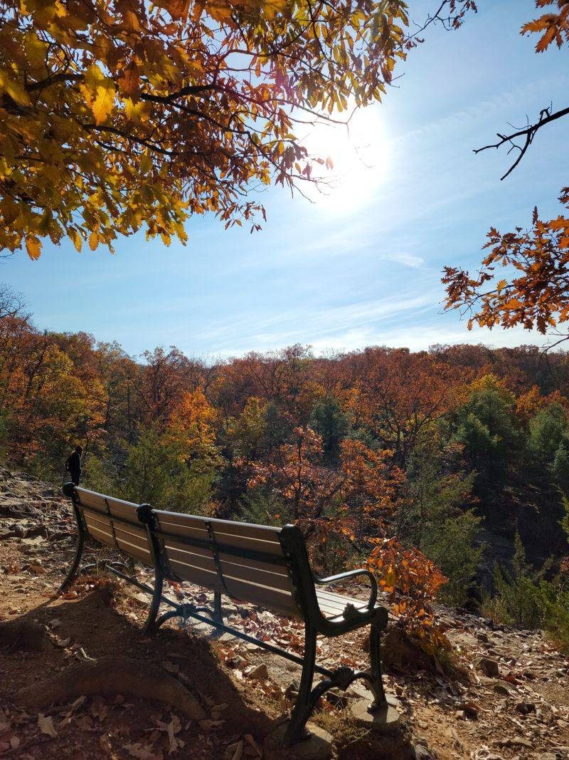
Sunfish Pond Overlook
Your journey culminates at the Sunfish Pond Overlook, a rocky promontory on the northern shore that offers sweeping panoramic views of the entire glacial basin. From this elevated vantage point, the pond’s oval shape becomes apparent, and you can trace the shoreline’s curves as they disappear into forest shadows.
The Kittatinny Ridge stretches away to the northeast, its forested spine forming the backbone of this section of the Appalachian Trail. On exceptionally clear days, you can see all the way to the Delaware Water Gap itself, where the river breaches the ridge miles to the south.
The overlook attracts hikers like a magnet, and you’ll likely share the space with others who’ve made the pilgrimage. Conversations flow easily here, with strangers swapping trail stories and offering each other snacks from their packs.
The communal atmosphere reflects the trail magic that makes the Appalachian Trail community so special. Someone always seems to have a camera or phone out, capturing images that never quite do justice to the real experience but still serve as treasured mementos.
Springtime weather can be unpredictable at this elevation. Clouds sometimes roll in suddenly, engulfing the overlook in mist and reducing visibility to mere yards.
Other times, brilliant sunshine illuminates every detail, from individual trees on distant ridges to the intricate patterns of ripples crossing the pond’s surface. Wind often gusts across the exposed rocks, carrying the scent of pine and the distant sound of ravens calling from the forest canopy.
Eventually, reality intrudes and you must begin the descent back to the trailhead. The return journey feels different somehow, with tired legs protesting the downhill grades and familiar landmarks passing in reverse order.
Yet the memory of Sunfish Pond stays with you, a highland jewel that makes every step worthwhile and calls you back for future visits.
Dear Reader: This page may contain affiliate links which may earn a commission if you click through and make a purchase. Our independent journalism is not influenced by any advertiser or commercial initiative unless it is clearly marked as sponsored content. As travel products change, please be sure to reconfirm all details and stay up to date with current events to ensure a safe and successful trip.