High above the tree line in Colorado, a quiet ghost town waits with views that stop you in your tracks. Carson, Colorado rewards those willing to take the rough road with crisp air, big skies, and history you can touch. You will stand among weathered cabins and feel the hush of the Weminuche Wilderness wrap around you. Keep reading to plan a safe, thoughtful visit that treats this fragile place with care.
Reaching Carson on Wager Gulch Road
Carson, Colorado sits off Wager Gulch Road, a steep high alpine track that demands a true 4×4 and confident low range driving.
The climb begins near Lake City at County Road 30, then turns onto County Road 33, also called Wager Gulch Road, where loose rock and ruts appear quickly.
Momentum is your friend on short climbs, but patience matters more, because the shelf sections are narrow and shoulders can be soft after storms.
June through October tends to be the realistic window, since snow lingers in shaded gullies and early icy patches can appear without warning.
Always check recent trip reports, local ranger notes, and weather forecasts, then build a turn around plan before the final ascent.
Do not rely on cell coverage, since the signal fades as the gulch narrows and ridgelines block line of sight to towers.
Carry a paper map, a GPS track, and a tire repair kit, and air down only if you know you can air back up safely.
Parking is limited near the site, so pull fully off the road where vegetation will not be crushed or eroded.
The address is Wager Gulch Road, Lake City, Colorado 81235, which gets you to the approach rather than a staffed destination.
Respect private property signs near the townsite and keep gates exactly as you found them.
Slow travel here preserves the route and keeps dust down for those hiking the upper switchbacks.
You will feel the altitude on every step, so sip water often and take breaks as the views widen.
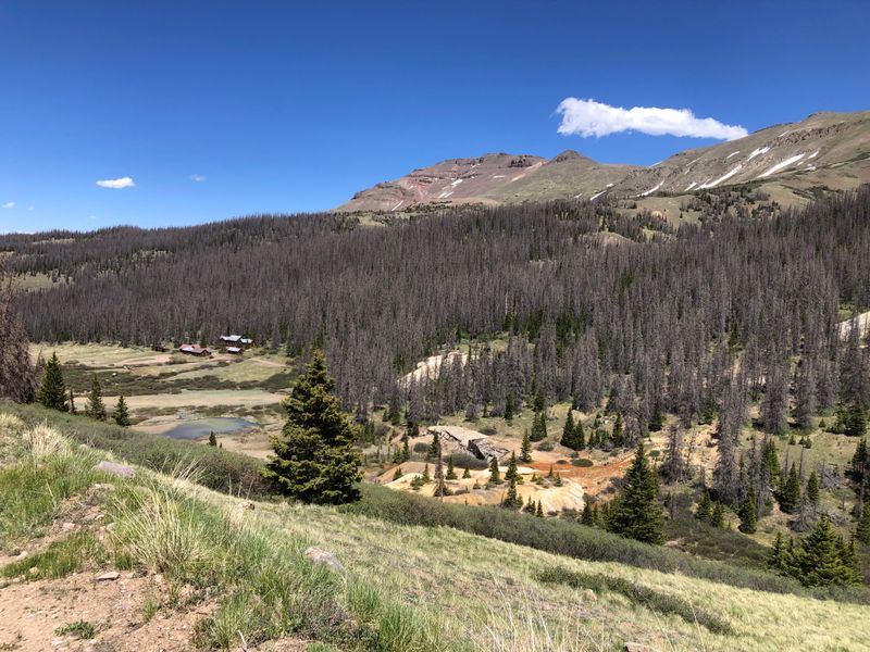
First Glimpse of the Alpine Loop Spur
The Alpine Loop connects classic passes, yet the spur to Carson peels into a quieter bowl where wind carries only the sound of pikas.
As you crest a knoll, a handful of log structures appear, small against a horizon packed with granite and snowfields.
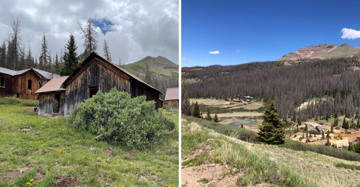
The Weminuche Wilderness fills the skyline like a serrated wall, and the Rio Grande Pyramid rises with unmistakable triangular grace.
Even in summer, the air holds a chill that hints at why winters once emptied these cabins without ceremony.
The address to reference is Alpine Loop, near County Road 33, Lake City, Colorado 81235, which indicates the spur rather than a staffed facility.
Here, tundra plants grow slowly, so keep to the roadbed and existing paths to avoid cutting fragile mats.
Clouds change the mood by the minute, casting shadows that move like tides across the basin.
You can pause at a wide turn to take in the layered ranges, then roll forward with low throttle for traction.
The side valleys hold remnant drifts well into the season, and meltwater braids through gravel fans beside the track.
Look for wooden fence remnants and rusted cans that tell small stories of everyday work.
The spur feels removed from the busier passes, and that calm is part of the town’s delicate charm.
Leave it as you found it so the next traveler feels the same breath of open Colorado country.
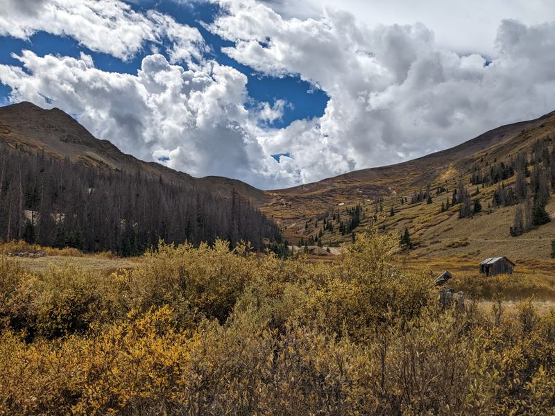
Old and New Carson Townsites
Carson includes two areas, often called New Carson with more intact cabins, and Old Carson scattered lower with heavier decay.
They sit on private property, and respectful viewing from roads and obvious pullouts is the right way to take it in.
Do not enter buildings, because logs have shifted and floors can mask voids that drop to cold earth.
The address reference is Carson Townsite, near Wager Gulch Road, Lake City, Colorado 81235, which points to the ridge zone rather than an office.
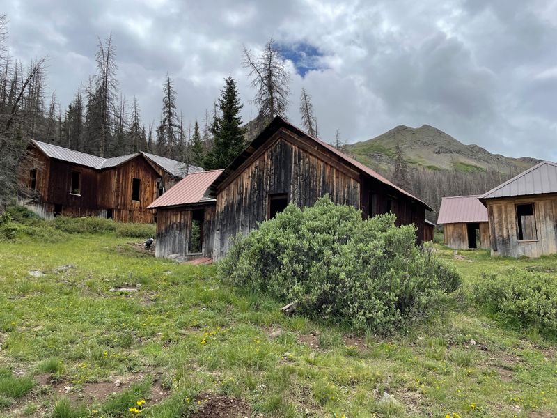
Roofs sag, doors hang, and windows frame sky, yet details remain, like axe marks and dovetail corners on hand hewn logs.
New Carson aligns along the higher track, while Old Carson’s remnants tend to blend into willows and grass.
Sunrise paints the upper cabins with pale gold, and shadows settle quickly as afternoon storms build.
Each structure feels like a sentence from a longer chapter about ore, snow, and the math of distance.
Signs sometimes mark boundaries, so keep tires and boots on the public corridor without stepping across.
Birdsong carries through the square cut gaps, and wind rattles tin that refuses to let go.
From a respectful distance, photographs capture textures without touching anything fragile or loose.
You will leave with the feeling that time still lives here, quiet and entirely Colorado.
Mining Past in the High Country
The town began with silver and gold hopes, then grew quickly as claims stitched across the high basin.
Work followed short summer seasons, with ore hauled over rough grades that tested hooves, wheels, and temper.
When storms stacked deep, families pulled back to lower valleys and returned as thaw unlocked the ground.
Cabins show the logic of short commutes, set near adits and dumps to save precious daylight.
The address marker for context is Carson Historic Area, Wager Gulch Road, Lake City, Colorado 81235, covering the dispersed remnants rather than a museum.
Tailings lie in pale fans, and you can read layers where the vein pinched or widened.
Nails, stove parts, and glass fragments may still hide in grass, so leave any artifacts where they lay.
Snowfields often fed flumes and barrels that stored water for washing ore and living chores.
Tool marks around beam notches tell of precise fits cut without power tools or modern jigs.
Stories of boom and pause remain in the layout, concise and practical rather than grand.
Silence now replaces the clang of steel, yet the setting still whispers about effort spent at altitude.
Every view reminds you that Colorado’s mountains shape both prosperity and the limits that follow it.
Weather, Altitude, and Safe Timing
At nearly twelve thousand feet, Carson sits where weather turns quickly and wind can scrape warmth from bare skin.
Afternoons often build clouds that spit graupel, then snap clear, so morning starts help avoid slick ruts.
June through October usually offers the best chance, though late storms can close the road without much warning.
Hydration and a steady pace reduce headaches and fatigue, since altitude works quietly on visitors from lower valleys.
The reference address is Wager Gulch Road Access, Lake City, Colorado 81235, which marks the approach rather than a staffed gate.
Pack layers, including a wind shell, gloves, and warm hat even on bright days.
Footing shifts on rounded talus, so sturdy shoes help on short walks to photo spots.
Watch the sky every few minutes and set a turnaround time that you will actually follow.
If thunder rolls, move off high points and avoid lone trees or open ridge lines.
Carry extra water, a small first aid kit, and a headlamp since dusk arrives faster behind peaks.
A printed map backs up GPS units that can drift near cliffs or tight drainages.
Plan well, and Colorado’s high country rewards you with clarity and calm between storms.
Weminuche and Rio Grande Pyramid Views
The vista from Carson sweeps toward the Weminuche Wilderness, where peaks layer in steel blue bands.
On a clear day, the Rio Grande Pyramid stands like a beacon, its triangle profile easy to spot above ridges.
Light changes the scene constantly, painting ripples across meadows and streaking shadow through couloirs.
Morning sun warms the tundra and lifts thin mist that clings to willows along the creek.
The viewing area has no formal platform, but the reference is Carson Overlook Area, Wager Gulch Road, Lake City, Colorado 81235.
Keep lenses and hands off delicate logs, using open ground for stable tripod legs.
Wind may shove the camera, so a weighted pack helps hold still during longer exposures.
Wildflowers appear in quick waves, then vanish as frost returns and seeds wait for next year.
The quiet can feel absolute, broken only by chirps from pikas and the wingbeat of a hawk.
Cloud banks sometimes pour over the divide like slow water, erasing distance until sunlight leaks through.
These are Colorado views that reset your sense of scale without needing summit effort.
Take a breath, look long, and let the range write its own slow story in your memory.
Respecting Private Property and Site Etiquette
Carson’s townsite includes private parcels, so visiting means staying on existing roads and obvious pullouts at all times.
Structures are fragile and legally protected, and entering puts both you and the site at risk.
Good etiquette keeps places open, since respectful travel sets a positive example for everyone who follows.
Pack out everything you bring, including tissues and orange peels that do not belong at altitude.
The address reference is Carson Townsite Area, near Wager Gulch Road, Lake City, Colorado 81235, with no visitor center or services.
Leave artifacts exactly where you see them, because context tells historians more than any label ever could.
Park in hardened spots without crushing tundra, and avoid spinning tires that cut ruts.
Dogs should stay close and under control so wildlife does not bolt through fragile ground cover.
Drone use can disturb wildlife and privacy, so check local restrictions and choose quiet observation instead.
Share the route with other drivers by yielding on wider sections and keeping speeds slow.
A simple wave builds goodwill on narrow tracks where cooperation keeps mirrors intact.
Stewardship here honors Colorado’s past and keeps the experience authentic for the next traveler.
Seasonal Access and Road Reports
Before turning up Wager Gulch, check current road conditions with Hinsdale County updates and recent high country reports.
Snow drifts, downed trees, or washouts can change plans faster than any itinerary can adapt.
Local shops in Lake City often hear about obstacles first, and they can point you to verified sources.
Travel outside the usual season risks damage to the route and puts rescuers in tough spots.
The junction address to note is County Road 30 and County Road 33, Lake City, Colorado 81235, the place where decisions happen.
If crews are working, give them space and keep tires on compacted surfaces to limit further erosion.
Storm cells release heavy rain that funnels into ruts, which can trap differentials without finesse.
Air pressure adjustments help on rock, yet do not fix deep mud that hides under thin crusts.
Carry a shovel and traction boards as a backstop to careful line choice.
If you meet oncoming traffic at a shelf, the uphill vehicle generally holds the right of way.
Patience and courtesy turn tight corners into easy exchanges with light hand signals.
Colorado rewards that mindset with safer travel and fewer surprises as the season shifts.
Photography Without Leaving a Trace
Photographers love Carson for textures, but the best images come from careful distance and clean frames.
Use longer lenses to isolate joinery and lichen, avoiding any need to lean on the wood.
Tripod feet belong on rock or packed soil, never on moss or fragile plant mats.
Golden hour warms the logs and smooths harsh ridgelines into gentle gradients of color.
The reference location is Carson Photography Pullouts, Wager Gulch Road, Lake City, Colorado 81235, which indicates general spots rather than platforms.
Compose wide to hold sky, then crop later if the lines feel stronger without extra foreground.
Watch for wind because grass blur can either ruin detail or add motion that fits the story.
Silhouettes of cabins against backlit clouds carry mood without stepping close to sagging beams.
Keep packs off windowsills and railings that could crumble under even a brief touch.
Walk single file where others have stepped so new tracks do not spider out across meadows.
Quiet work makes wild neighbors stay visible longer, which often becomes the favorite shot of the day.
Leave every angle intact so the next eye finds Colorado’s weathered lines exactly as you did.
Nearby Lake City Base Camp
Lake City makes a practical base for the Carson spur, with services, updates, and a friendly main street pace.
Historic facades line the core, and you can find maps, weather info, and trail advice without much detour.
Parking is straightforward, and the vibe invites a slow stroll before or after the high country drive.
The address anchor is downtown Lake City, 230 N Gunnison Ave, Lake City, Colorado 81235, which centers the small grid.
Public restrooms, a visitor center, and shops help you stage for a calm push up the gulch.
Ask about current washouts or treefalls, because locals hear first when something changes.
Lodging options span simple rooms to cabins, which makes early starts easy on cold mornings.
Riverside benches give a quiet wind down after the return, when altitude buzz begins to fade.
Respect crosswalks and low speeds through town, since the road doubles as a sidewalk in places.
Fuel, snacks, and last checks happen here, and you can sort gear before the grade begins.
The approach from Lake City keeps mileage short and leaves more time for safe photography.
Colorado towns like this tie the trip together, practical and welcoming without losing mountain character.
Dear Reader: This page may contain affiliate links which may earn a commission if you click through and make a purchase. Our independent journalism is not influenced by any advertiser or commercial initiative unless it is clearly marked as sponsored content. As travel products change, please be sure to reconfirm all details and stay up to date with current events to ensure a safe and successful trip.