Somewhere in the rugged highlands of southwest Virginia, a mountain trail winds upward through forest and fog until it spills into one of the most jaw-dropping geological spectacles east of the Rockies. I stumbled upon this place on a crisp autumn morning, and honestly, nothing could have prepared me for what waited at the top.
Massive sandstone walls rise on either side, narrow passageways twist and turn like a stone puzzle, and the whole scene feels like it belongs in a fantasy novel rather than the Virginia mountains. If you think Virginia is all about Civil War battlefields and coastal beaches, this place is about to flip that assumption completely upside down.
The Trail That Earns Every Step
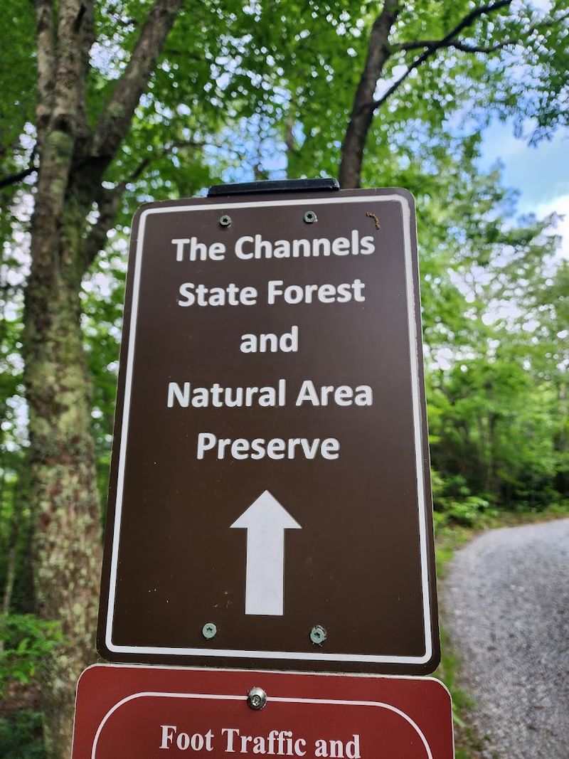
Nobody said the path to something extraordinary would be a stroll in the park. The Brumley Mountain Trail starts innocently enough as a wide gravel logging road, but do not let that fool you for a single second.
As the trail climbs toward the summit of Middle Knob on Clinch Mountain, the grade tightens, the trees close in, and your lungs start filing a formal complaint. The steepest sections pitch upward at grades that will have your calves burning and your hat tipping to the mountain in grudging respect.
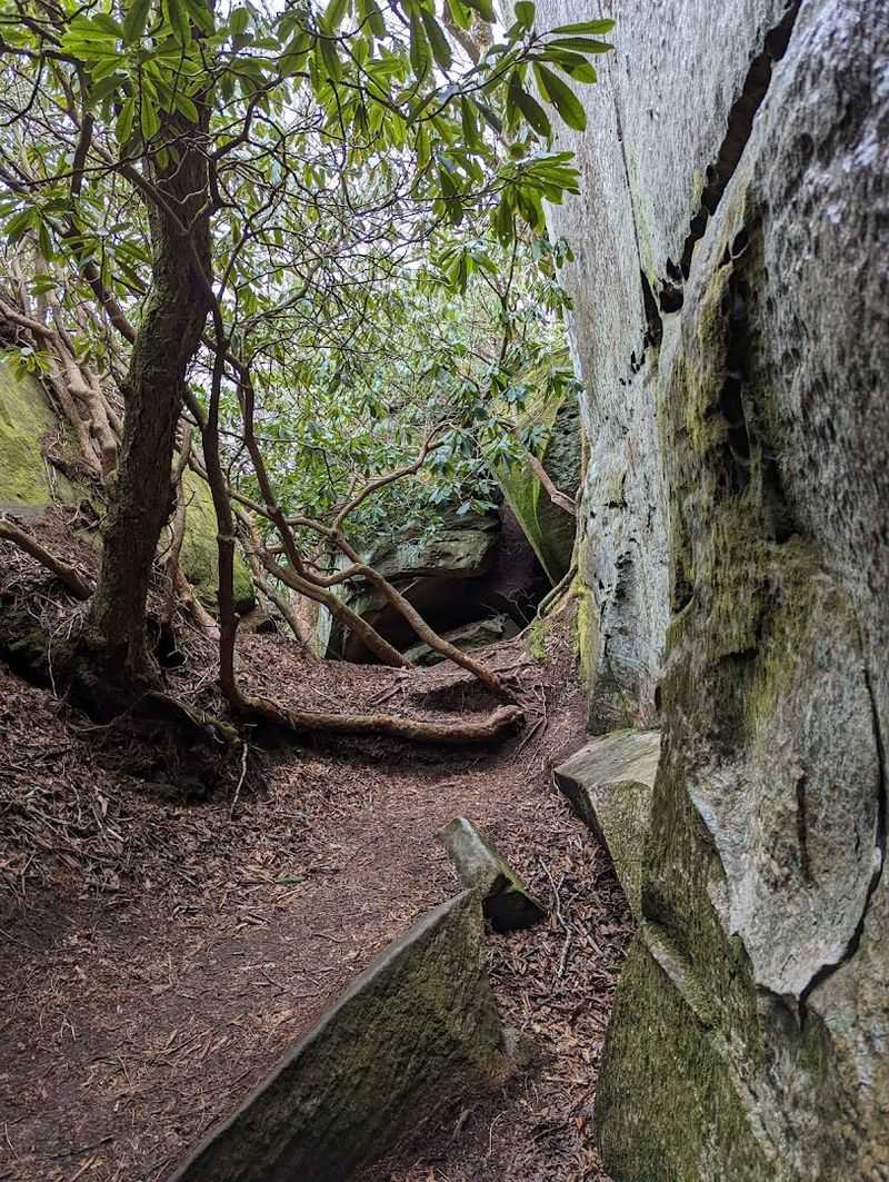
Patches of rhododendron line the upper trail, creating a tunnel of green that feels almost magical in late spring when the blooms explode in pink and purple. A fork appears near the top, and the left branch toward the Channels Spur is the one you want.
Missing that sign would be a genuinely sad outcome after all that climbing.
Good boots with ankle support are non-negotiable here. The surface shifts from packed gravel to loose rock as elevation increases, and a twisted ankle miles from the trailhead is nobody’s idea of adventure.
Pack water, pace yourself, and trust the trail.
Middle Knob Summit and the 360-Degree Payoff
Reaching the crest of Middle Knob feels like cresting a wave. One moment you are buried in forest, and the next the trees pull back and the entire Clinch Mountain range unfurls around you in every direction.
Standing on the exposed sandstone outcrops near the summit, I could see ridge after ridge rolling away into a blue haze that seemed to go on forever. Southwest Virginia has this way of making you feel both tiny and completely alive at the same time, and the summit of Middle Knob captures that feeling perfectly.
The view to the north sweeps across Russell County farmland stitched together in greens and browns, while the southern exposure drops into deep hollows thick with timber. On a clear day, the visibility stretches across multiple counties without a single obstruction.
Early morning visits reward patient hikers with a sea of cloud filling the valleys below while the summit stays bathed in golden light. Sunset visits are equally spectacular, painting the sandstone walls in shades of amber and rust.
Bring a camera with a wide-angle lens, because a phone screen simply cannot do this panorama justice.
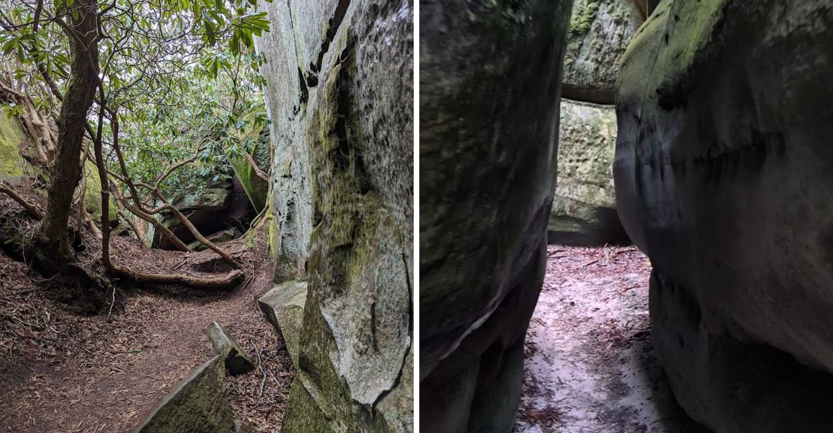
The Sandstone Labyrinth Up Close
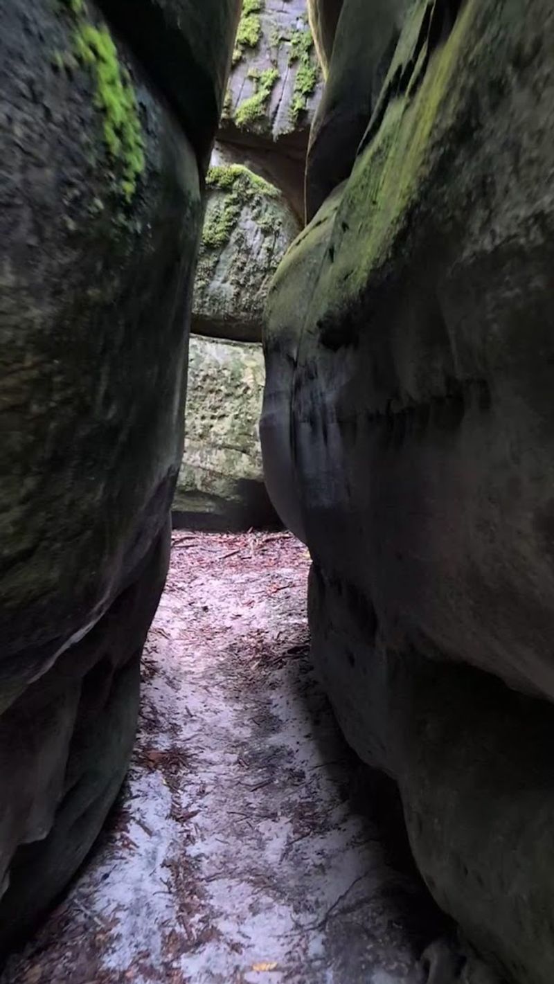
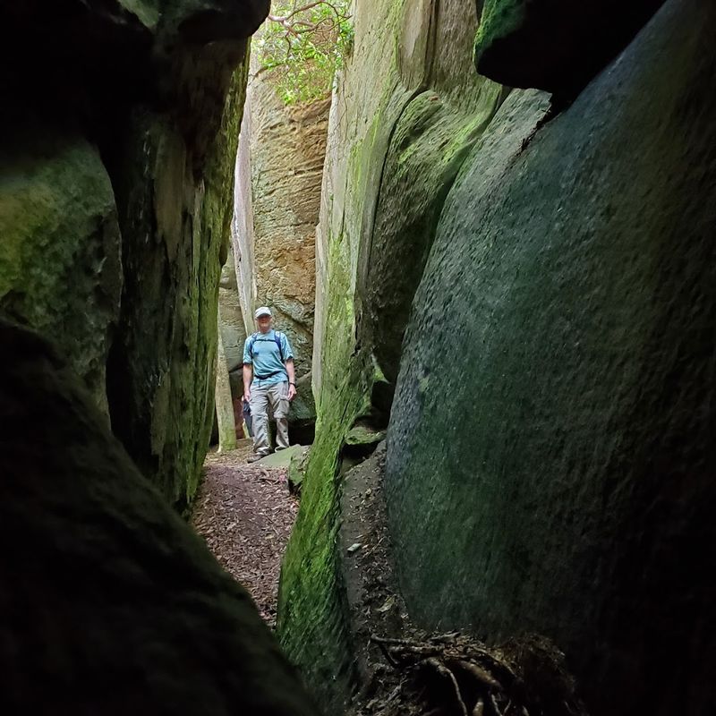
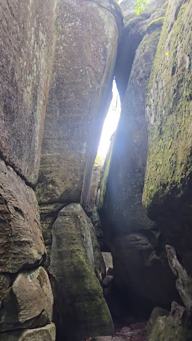
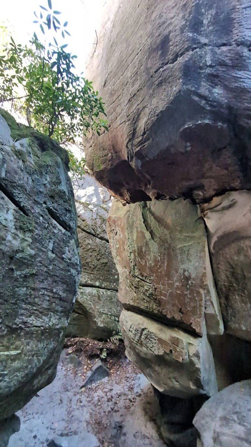
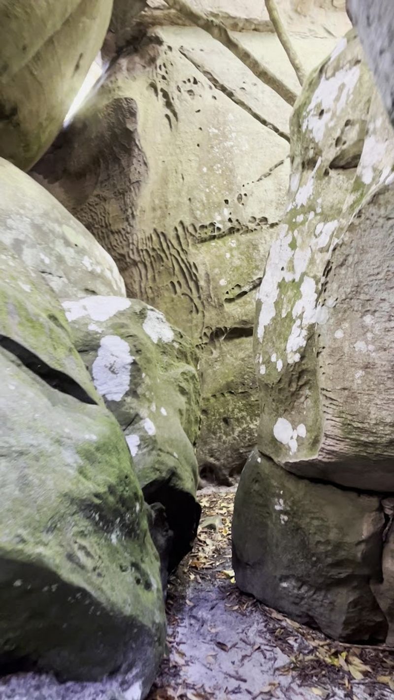
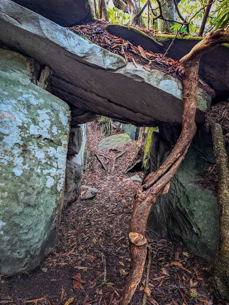
Nothing in my hiking experience quite prepared me for the first glimpse of the Great Channels. Enormous sandstone blocks, fractured and shifted over hundreds of millions of years, create a maze of passages that you can actually walk through, crawl into, and explore with genuine childlike wonder.
The crevices range from wide corridors that feel like stone hallways to slots so narrow that squeezing through requires turning sideways and exhaling completely. Some passages dead-end dramatically, others twist around corners to reveal hidden chambers draped in moss and shadow.
Looking up from inside a tight crevice, a sliver of sky frames itself between towering walls in a composition that no landscape photographer could resist. The sandstone surfaces glow in shades of rust, tan, and grey depending on moisture levels and the angle of available light.
The Great Channels cover roughly twenty acres of this fractured terrain, meaning a single visit barely scratches the surface of what is tucked away in here. Go slowly, look carefully around every corner, and resist the urge to rush through.
This is a place that genuinely rewards the curious and punishes the impatient.
How Ancient Ice Sculpted This Stone Maze
Geology rarely tells a story this dramatic. The sandstone forming the Great Channels began as sediment deposited on an ancient seafloor roughly four hundred million years ago, long before dinosaurs or flowering plants existed on Earth.
The real magic happened much more recently, during the last ice age, when permafrost and repeated cycles of freezing and thawing drove ice wedges deep into existing cracks in the sandstone caprock. Each freeze expanded the joints slightly, and over thousands of years that relentless mechanical force split the rock into the towering blocks and narrow passages visible today.
What makes the Great Channels particularly special in the eastern United States is that slot canyon formations of this scale are far more commonly associated with the desert Southwest. Finding something geologically comparable in the mountains of Virginia genuinely surprises most people who stumble upon it for the first time.
The Channels Natural Area Preserve protects this formation precisely because it is so rare and fragile. The sandstone surfaces, while seemingly massive, are sensitive to impact and erosion.
Staying on established paths within the channels keeps the geology intact for future generations who deserve to see this spectacle exactly as it stands today.
Hayter’s Knob Fire Tower and Its CCC Legacy
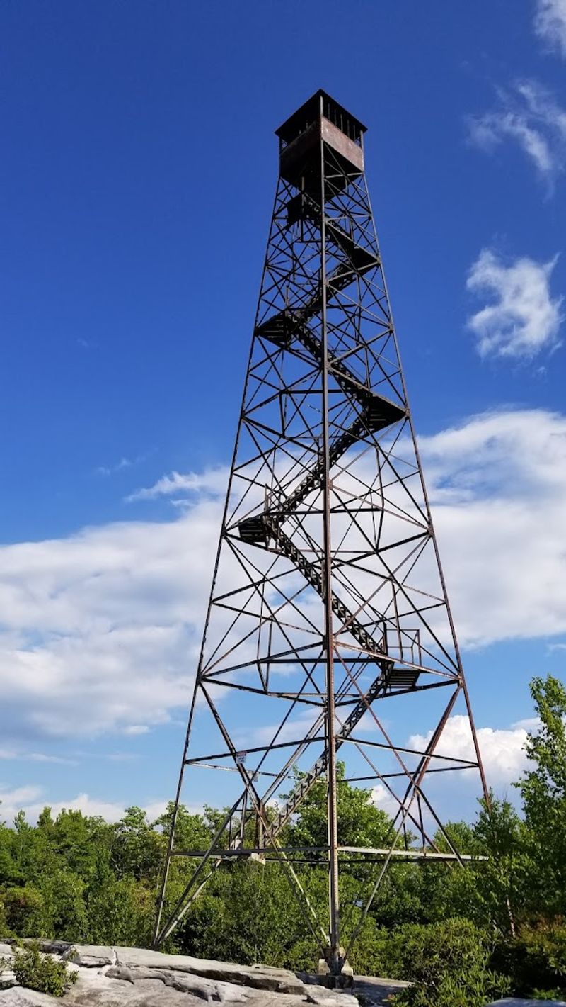
Perched near the summit, the skeletal frame of the Hayter’s Knob Fire Tower stands as a quiet monument to a remarkable chapter of American history. Built by the Civilian Conservation Corps in 1939, this tower once served as a critical early warning system for forest fires across the Clinch Mountain range.
The CCC was Franklin Roosevelt’s answer to the Great Depression, putting young men to work building trails, towers, and infrastructure across America’s wild places. The craftsmanship and determination behind structures like this one, hauled piece by piece up a mountain without modern machinery, is genuinely humbling to contemplate.
The tower operated for more than three decades before being retired from active service. Today it stands unclimbed and officially off-limits for safety reasons, but its presence adds a layer of human history to an otherwise purely natural landscape.
Reading the interpretive information posted near the base fills in the story beautifully.
Sitting on the nearby rock outcrops with the tower framed against a wide sky, the scene feels like something out of a different era entirely. Southwest Virginia has a talent for layering natural beauty with authentic historical weight, and this summit captures both qualities in one unforgettable spot.
Navigating the Channels Without Getting Gloriously Lost
Full transparency: getting slightly turned around inside the Great Channels is practically a rite of passage. The maze-like network of passages all start looking remarkably similar once you are deep inside, and the walls block most visual landmarks that would normally help with orientation.
The smartest move before entering is to identify a distinctive feature at your entry point, whether that is a particularly large boulder, a moss pattern, or a piece of trail marking. That reference point becomes your compass when the passages start looping back on themselves in confusing ways.
Going with at least one other person is genuinely wise here. Two sets of eyes navigate the channels far more effectively than one, and having company transforms potential disorientation from stressful to genuinely funny.
Solo exploration is possible but requires extra attentiveness to surroundings.
Cell service is unreliable or completely absent in this area, so downloading an offline map before leaving the trailhead parking area is a practical step worth taking. The Great Channels are thrilling precisely because they feel wild and unscripted, but a little preparation keeps the adventure firmly in the fun category rather than the frightening one.
Wildlife and Flora Along the Clinch Mountain Corridor
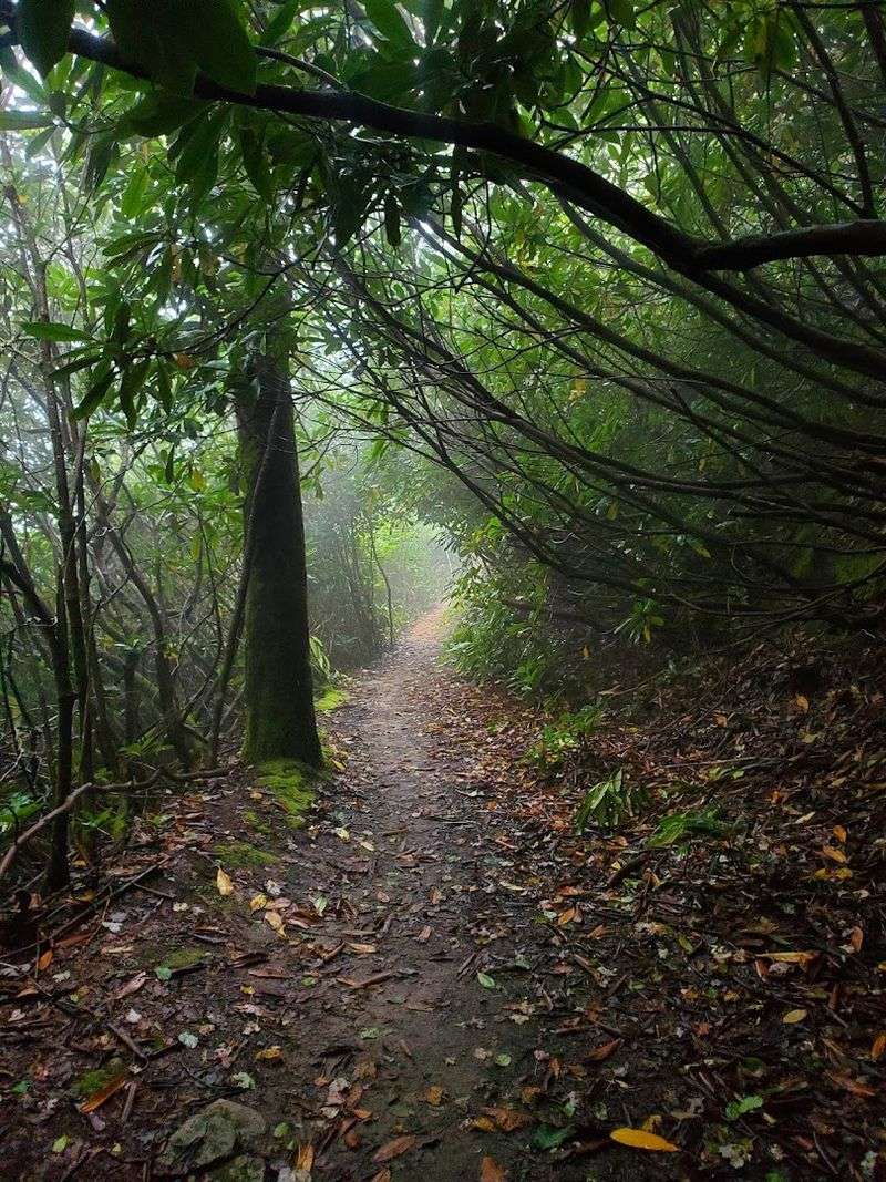
The trail to the Great Channels passes through a genuinely rich cross-section of Appalachian biodiversity. Dense rhododendron thickets crowd the upper trail, creating a living tunnel that bursts into spectacular bloom in late May and early June when the pink and white flowers open en masse.
Wildflowers dot the forest floor in spring, including trillium and wild geranium species that thrive under the canopy of oak and hickory that dominates the lower slopes. Deer are frequently spotted along the trail, particularly in the early morning hours before foot traffic picks up on popular weekend days.
Birdlife along the corridor is surprisingly active. The mixed forest habitat supports warblers, thrushes, and raptors that use the mountain ridgeline as a navigational corridor during migration seasons.
Stopping quietly on the trail for a few minutes often rewards patience with songbird sightings that go completely unnoticed by hikers moving at speed.
Mosquitoes deserve a mention here because they can be aggressive in summer, particularly in the shadier sections of the lower trail. Bug repellent is a genuine necessity from June through August.
The shoulder seasons of spring and fall offer the most comfortable hiking conditions and the most visually dramatic scenery along the entire route.
Parking, Planning, and Getting There Without Headaches
The parking situation at the Channels Natural Area Preserve is famously tight, and knowing this in advance saves a lot of frustration. Only ten numbered spaces exist at the trailhead off Virginia Highway 80, and roadside parking along the highway is strictly prohibited with active towing enforcement.
Arriving before ten in the morning on weekdays gives the best odds of securing a spot without waiting. Weekend mornings fill quickly, especially during peak foliage season in October and the rhododendron bloom window in late spring.
Carpooling with friends is genuinely the most practical strategy for groups.
The trailhead sits near the Washington and Russell County line in the southwestern corner of Virginia, roughly accessible from the town of Rosedale. The drive in from major highways winds through classic Appalachian farm country, offering scenic previews of the landscape before the hiking even begins.
There are no bathroom facilities at the trailhead, so plan accordingly before leaving your last town stop. Cell service drops significantly once you are on the trail, making pre-downloaded maps and offline navigation apps essential tools rather than optional extras.
A little logistical preparation transforms this trip from potentially stressful to completely seamless.
What To Pack for a Summit Sandstone Adventure
Packing smart for the Great Channels makes a noticeable difference between a genuinely great day and a miserable slog. The trail climbs consistently from the parking area to the summit, which means hydration needs are higher than a casual flat walk would suggest.
Two liters of water per person is a reasonable minimum.
Footwear matters enormously on this route. The lower trail is mostly packed gravel and old forest road, but the upper sections introduce loose rocks, exposed roots, and occasionally slippery surfaces after rainfall.
Trail shoes with good grip work, but mid-cut hiking boots with ankle support are the smarter choice for anyone exploring the channels themselves.
Layering clothing is wise because summit temperatures on Clinch Mountain can run noticeably cooler than the valley, and afternoon clouds can roll in quickly during summer months. A lightweight waterproof shell stuffed into a daypack adds almost no weight but earns its keep instantly when a shower arrives without warning.
Snacks that pack energy without bulk make the summit experience far more enjoyable. Many people settle onto the broad sandstone outcrops near the fire tower for a proper lunch break with that sweeping Virginia mountain panorama as the backdrop, and honestly, that is one of the best picnic spots in the entire state.
Why The Great Channels Belong on Every Virginia Bucket List
Some places earn their reputation through marketing. The Great Channels earned theirs through sheer geological spectacle and the fact that almost nobody outside of southwest Virginia seems to know they exist.
That combination of quality and obscurity is genuinely rare in the modern age of over-documented outdoors destinations.
The experience of standing inside a twenty-acre maze of towering sandstone, knowing that ice and time carved every passage over thousands of years, connects you to deep geological time in a way that few accessible natural areas can match. This is not a manicured overlook with a guardrail and a gift shop.
It is raw, wild, and completely on its own terms.
Virginia offers extraordinary outdoor experiences across its geography, from the coast to the Shenandoah Valley to the Blue Ridge Parkway, but the Great Channels occupy a category entirely their own. Nothing else in the state quite replicates the feeling of turning a corner inside those crevices and finding another hidden chamber waiting.
The address for your navigation app is Rosedale, VA 24280, with the trailhead located off Virginia Highway 80. Pack your boots, charge your camera, and get out there before the word spreads any further and those ten parking spots become the most contested real estate in all of Virginia.
Dear Reader: This page may contain affiliate links which may earn a commission if you click through and make a purchase. Our independent journalism is not influenced by any advertiser or commercial initiative unless it is clearly marked as sponsored content. As travel products change, please be sure to reconfirm all details and stay up to date with current events to ensure a safe and successful trip.