The wind moves differently here, cutting through what is left of old storefronts and weathered timber like it remembers something we do not. This South Dakota town once pulled staggering amounts of gold from the ground, with thousands of hopeful people calling a dusty camp home. A flume built in the eighteen seventies stretched nearly twenty miles through rugged terrain to keep mining operations going.
Today that route is a hiking trail. Old foundations peek through the grass.
The silence does most of the talking now. I stumbled onto this place almost by accident, and honestly, I am glad I did. Pickaxes echo through the hills without anyone swinging them.
There is no gift shop here, no admission fee, no curated experience telling you what to feel. Just the land, the remnants of a boom that went bust, and the kind of quiet that makes you stop checking your phone without even realizing it. That is the real draw.
That is the whole point.
The Gold Rush Origins That Put Rockerville on the Map

Gold has a way of turning empty land into a city almost overnight. That is exactly what happened in Rockerville when William Keeler discovered placer gold in February 1877, kicking off one of the most concentrated rushes in Black Hills history.
The town did not waste any time growing up around that discovery.
Within just a few years, Rockerville had swelled to around 1,000 residents, with hundreds of buildings packed into a camp that barely existed before the gold showed up. By 1878, approximately $250,000 worth of placer gold had already been pulled from the area.
That was a jaw-dropping amount of wealth for such a short stretch of time.
The name Rockerville itself is a nod to the “rockers” miners used, wooden contraptions that separated gold flakes from stream gravel through a rocking motion. It was labor-intensive, muddy, and exhausting work.
But nobody seemed to mind when the payoff glittered in the pan.
What made this spot unusual was the sheer scale of its placer deposits. The Black Hills had other mining towns, but Rockerville earned the specific title of the “banner placer district” of the entire region.
That kind of reputation drew people from all directions.
Understanding where Rockerville started makes the silence you find there today feel much louder. The ground underfoot was once fought over, celebrated, and desperately worked.
You can almost feel that history pressing up through the soil when you visit.
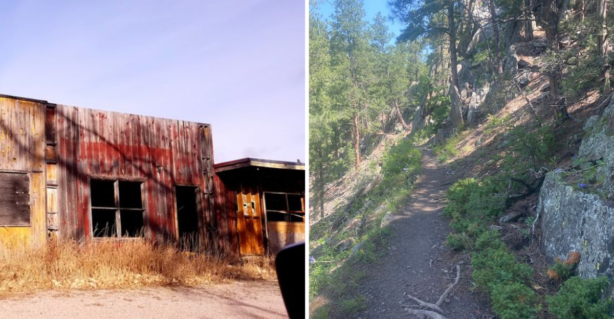
Most of what was built is gone now, just fragments and foundations half swallowed by grass and weeds. But the Flume Trail remains, tracing the old water channel through the hills.
Walking it gives you a sense of scale that no museum exhibit could capture.
The miners who swung those pickaxes are long gone, but the echo of their work still lives in the shape of the land. That is the real history of Rockerville, written not in books but in the ground itself.
A Flume That Stretched for Miles Through the Hills

One of the most impressive engineering feats tied to Rockerville is something most visitors have never even heard of. To solve a serious water shortage that was slowing down hydraulic mining operations, a flume was constructed in 1878 to carry water from Spring Creek all the way to the mining sites.
It stretched somewhere between 17 and 20 miles through rugged Black Hills terrain.
Building something like that through dense forest and uneven ground, using mostly hand tools and sheer determination, is hard to wrap your head around today. The flume remained active until 1885, feeding the hydraulic mining operations that replaced the earlier hand-rocker method.
It was an engineering solution born out of necessity, and it worked remarkably well for its era.
Today, the route of that historic flume has become the Flume Trail, a hiking path that traces the old channel through the Black Hills. Sections of the original wooden structure can still be spotted along the way, weathered and leaning but still recognizable.
Hiking it feels like reading a chapter of history with your feet.
The trail offers dense tree cover, rocky terrain, and moments where the land opens up into sweeping views. It is not a casual stroll, but it is absolutely worth the effort.
There is something grounding about walking a path that miners once depended on for survival.
The Flume Trail connects modern outdoor recreation to a very specific slice of Black Hills industrial history, and that combination is genuinely rare to find anywhere.
The Boom, the Bust, and the Long Quiet That Followed

Every boom has a ceiling, and Rockerville hit its hard. As the placer gold deposits thinned out and hydraulic mining became less productive, the population quietly drained away.
The post office, often the last institution to leave a dying town, finally closed in 1915.
By 1930, most of what had been a thriving mining camp was already collapsing into ruin. Buildings that once housed saloons, general stores, and packed bunkhouses were rotting back into the hillside.
The town that had earned a regional nickname for its gold output was becoming a footnote.
Then something unexpected happened. In the 1950s and 1960s, Rockerville got a second life as a tourist stop, conveniently positioned along US Highway 16 between Rapid City and Mount Rushmore.
Entrepreneurs leaned into the ghost town aesthetic, setting up melodrama theaters, tourist shops, miniature museums, and gold panning activities. For a while, it genuinely worked.
The revival did not last. When US Highway 16 was rerouted around Rockerville in the mid-1960s, the tourist traffic dried up almost immediately.
By the 1990s, the town was described as virtually dead, and the phrase “Rockerville Syndrome” entered South Dakota conversation as a way of describing sudden, severe economic collapse in a small community.
In 2016, some of the remaining historic structures were intentionally burned during a fire training exercise, which closed a chapter on the town’s physical history. What remains today is sparse, quiet, and oddly moving to witness in person.
What Still Stands in Rockerville Today

Visiting Rockerville now requires adjusting your expectations in the best possible way. This is not a polished heritage site with interpretive signs and gift shop tote bags.
It is a genuine ghost town with just enough life left in it to feel like something rather than nothing.
The Gaslight, which was rebuilt after a fire destroyed an earlier version, remains one of the few active businesses in the area. It operates as a restaurant and lodge, giving travelers a reason to stop and sit a while.
Finding a functioning spot in a town this quiet feels almost surprising.
Most of the older tourist-era structures from the 1950s and 1960s revival have either closed, deteriorated beyond use, or been removed entirely. What is left behind are fragments: a few weathered facades, empty lots where buildings once stood, and the particular stillness that only genuinely abandoned places carry.
There is no manufactured spookiness here, just the real kind.
Some newer tourism efforts have emerged around the lodge and restaurant, suggesting that people have not entirely given up on Rockerville as a destination. It is a slow rebuild, nothing dramatic, but the effort feels genuine.
The community, such as it is, seems to understand what it has.
The Flume Trail trailhead is also accessible from this area, making Rockerville a logical base for hikers heading into the Black Hills. Combining a trail walk with a stop at the Gaslight makes for a surprisingly full and satisfying afternoon in a place most people drive right past.
Why Rockerville Deserves a Spot on Your Black Hills Road Trip

The stretch of highway between Rapid City and Mount Rushmore is one of the most traveled roads in South Dakota. Most people blow right past Rockerville without a second glance.
That is genuinely their loss, and I say that without exaggeration.
There is a particular kind of travel experience that only ghost towns can offer. No crowds, no admission fees, no curated narratives telling you exactly what to feel.
Rockerville hands you a landscape and a history and lets you make of it what you will. That kind of freedom is harder to find than it sounds.
The Black Hills region is already packed with heavy hitters: Mount Rushmore, Crazy Horse Memorial, Custer State Park, and Deadwood. Adding Rockerville to that list does not dilute the trip.
It deepens it by offering contrast, a quieter, rougher, more honest version of what this land has been through.
Geology nerds, history enthusiasts, hikers, and road trip wanderers all find something here worth their time. The Flume Trail alone is reason enough to plan a stop.
Pair it with a meal at the Gaslight and a slow walk around what remains of the town, and you have carved out a genuinely memorable few hours.
Rockerville is the kind of place that sticks with you not because it overwhelmed your senses, but because it asked you to pay attention. Places like that are rarer than gold these days, and just as worth seeking out.
Address: Mount Rushmore, SD 57702
Dear Reader: This page may contain affiliate links which may earn a commission if you click through and make a purchase. Our independent journalism is not influenced by any advertiser or commercial initiative unless it is clearly marked as sponsored content. As travel products change, please be sure to reconfirm all details and stay up to date with current events to ensure a safe and successful trip.