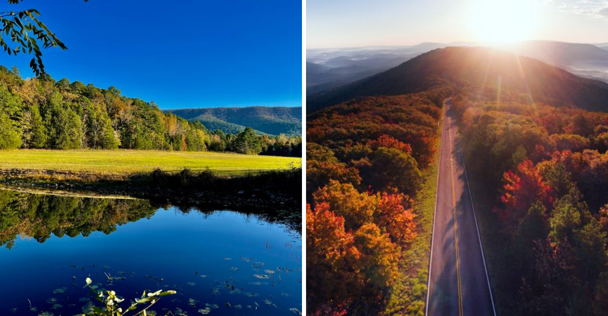
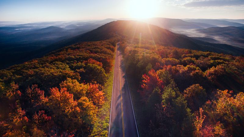
I still remember the first time I drove the Talimena National Scenic Byway. The road twisted ahead of me like a ribbon through the Ouachita Mountains, and every curve revealed something more stunning than the last.
This 54-mile stretch connecting Talihina, Oklahoma, to Mena, Arkansas, ranks among the most spectacular drives in the entire region.
Built in the 1960s specifically to showcase the natural beauty of southeastern Oklahoma, the byway climbs to over 2,600 feet in elevation and delivers panoramic views that will make you pull over again and again.
Spring wildflowers carpet the hillsides, summer greenery creates a lush canopy, fall foliage explodes in brilliant reds and golds, and winter offers crisp, clear vistas for miles. I found myself planning return trips before I even finished my first journey along this remarkable road.
The Route Runs Through Ancient Mountain Ranges
The Ouachita Mountains are among the oldest mountain ranges in North America, and driving through them feels like traveling back through geological time. These east-west trending mountains formed over 300 million years ago, making them distinct from most North American ranges that run north-south.
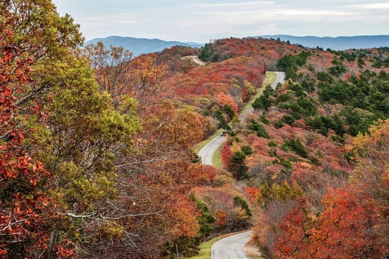
As I navigated the curves of Oklahoma Highway 1, I could see layer upon layer of ancient sedimentary rock exposed in the roadcuts. The mountains here aren’t towering peaks but rather rolling ridges covered in dense hardwood forests.
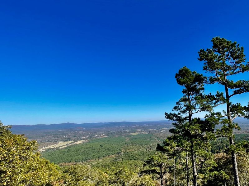
The highest points along the byway offer views that stretch for 50 miles or more on clear days.
What struck me most was how untouched everything felt. Unlike many scenic drives that pass through developed areas, this route maintains its wild character throughout.
The Ouachita National Forest surrounds the road, protecting over 1.8 million acres of woodland.
I recommend starting your drive early in the morning when mist often fills the valleys below, creating an ethereal landscape. The changing light throughout the day transforms the views completely, so if you have time, consider driving it twice.
Fourteen Official Overlooks Provide Perfect Photo Opportunities
Planning where to stop along the byway is easy because the route features fourteen designated overlooks, each offering unique perspectives of the surrounding landscape. I visited every single one during my trip, and each delivered something different.
The Oklahoma overlooks on the western section tend to showcase broader valley views and distant ridge lines. Many include informational signs explaining the geology, ecology, and history of the area.
Some overlooks have picnic tables, making them perfect for a scenic lunch break.
I particularly enjoyed the overlooks near the Oklahoma-Arkansas border, where you can literally see into two states at once. The pull-offs are well-maintained with paved parking areas and clear sight lines.
Several overlooks are wheelchair accessible, which I appreciated seeing.
During peak fall color season in mid-October, these overlooks become extremely popular. I visited on a weekday morning and still encountered other travelers at most stops.
Weekends draw even larger crowds, so arrive early for the best experience and parking availability.
Bring your camera with a wide-angle lens because the vistas are expansive and difficult to capture in a single frame.
Fall Foliage Creates a Kaleidoscope of Color
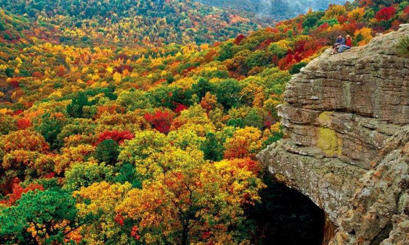
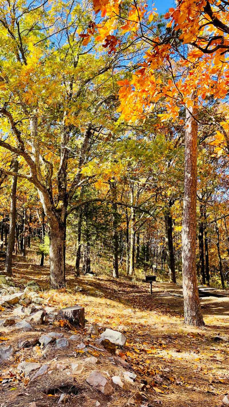
October transforms the Talimena National Scenic Byway into one of the most colorful places in Oklahoma. The hardwood forests explode with reds, oranges, yellows, and golds as oaks, maples, hickories, and sweetgums change color.
I timed my visit for the third week of October, which locals told me is usually peak season.
The color progression happens gradually as you gain elevation. Lower areas might still show green while higher ridges display full autumn brilliance.
This creates a layered effect that makes the landscape look painted. I found myself stopping at nearly every overlook because the views kept getting better.
The byway hosts an annual fall foliage event that draws thousands of visitors from across the region. Traffic increases significantly during this time, but the experience is worth the company.
Many visitors ride motorcycles along the route, and I saw dozens of touring bikes during my drive.
If you plan to visit during fall color season, book accommodations well in advance. Hotels and cabins in Talihina fill up quickly.
I also recommend filling your gas tank before starting the drive, as services are limited along the route itself.
Spring Wildflowers Blanket the Mountain Slopes
While fall gets most of the attention, spring along the Talimena National Scenic Byway offers equally stunning beauty. April and May bring waves of wildflowers that carpet the forest floor and open meadows along the route.
I visited in late April and encountered fields of purple verbena, yellow coreopsis, and white dogwood blossoms.
The wildflower display starts at lower elevations and moves upward as temperatures warm. This means you can catch different blooming stages depending on where you are along the byway.
Roadside areas that receive more sunlight tend to have the densest flower coverage.
I noticed that spring also brings incredible bird activity to the area. The forests were alive with birdsong, and I spotted several species of warblers, tanagers, and other migrants passing through.
Bring binoculars if you enjoy birdwatching because the opportunities are excellent.
Spring weather in Oklahoma can be unpredictable, so pack layers and rain gear. I experienced both sunshine and brief showers during my drive.
The changing weather actually enhanced the experience, creating dramatic cloud formations and temporary waterfalls on the hillsides.
Traffic is lighter in spring compared to fall, making it easier to enjoy a leisurely drive.
The Road Reaches Elevations Over 2,600 Feet
Starting near Talihina at about 600 feet elevation, the byway climbs steadily to reach heights exceeding 2,600 feet at several points. This significant elevation gain creates noticeable changes in temperature and vegetation as you drive.
I felt the temperature drop by at least ten degrees between the valley and the highest points.
The elevation provides those jaw-dropping panoramic views that make this drive so special. From the highest overlooks, you can see mountain ridge after mountain ridge fading into the distance.
On exceptionally clear days, visibility extends for 50 miles or more in every direction.
I noticed that the higher elevations support slightly different plant communities. Oak and hickory forests dominate throughout, but pine trees become more common at certain elevations.
The changing forest composition adds visual interest to the drive.
The elevation also means that weather conditions can vary significantly from what you left behind in lower areas. I started my drive on a warm, sunny morning but encountered fog and cooler temperatures at the highest points.
This variability adds to the adventure but requires preparation.
If you’re sensitive to elevation changes, take your time and enjoy the gradual climb rather than rushing through.
Wildlife Sightings Add Excitement to Your Journey
The Ouachita National Forest surrounding the byway supports diverse wildlife populations, and I encountered several species during my drive. White-tailed deer are the most commonly seen animals, and I spotted at least a dozen browsing near the roadside, especially during early morning hours.
Black bears inhabit these mountains, though sightings are less common. I didn’t see any during my trip, but I spoke with other travelers who had spotted bears from the road.
If you do see a bear, observe from inside your vehicle and never approach or feed wildlife.
Wild turkeys strut along the roadside and through the forests, and I saw several flocks during my drive. The area also hosts armadillos, which I found amusing to watch as they rootled through the leaf litter.
Fox squirrels are abundant and noticeably larger than the gray squirrels common in other parts of Oklahoma.
Birdwatchers will find excellent opportunities along the byway. I identified red-tailed hawks soaring above the ridges and heard the distinctive calls of pileated woodpeckers in the forests.
Spring and fall migrations bring additional species through the area.
Drive carefully, especially at dawn and dusk when wildlife is most active near the road.
Hiking Trails Branch Off from Multiple Access Points
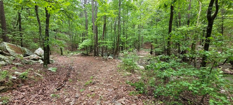
Several hiking trails intersect with or branch off from the Talimena National Scenic Byway, offering opportunities to explore the landscape on foot. I hiked a portion of the Ouachita National Recreation Trail, which actually crosses the byway at several points during its 223-mile length through Oklahoma and Arkansas.
The trail segments near the byway range from easy walks to more challenging climbs. I chose a moderate section that led to a rocky outcrop with panoramic views even better than those from the road.
The trail was well-marked and maintained, though I recommend wearing sturdy hiking boots because the terrain can be rocky.
Shorter interpretive trails near some overlooks provide quick nature walks perfect for families with children. These loops typically cover less than a mile and include informational signs about the local ecology and geology.
I walked one that explained the unique east-west orientation of the Ouachita Mountains.
If you plan serious hiking, bring plenty of water and let someone know your plans. Cell phone coverage is spotty along much of the byway.
Trail maps are available at the Talimena State Park visitor center near the western end of the route.
Talihina Serves as the Western Gateway

Talihina, Oklahoma, sits at the western terminus of the Talimena National Scenic Byway and serves as the natural starting point for eastbound travelers. This small town of about 1,000 residents provides essential services including gas stations, restaurants, and lodging options.
I stopped here to fuel up and grab supplies before beginning my drive.
The town’s name comes from Choctaw words meaning “iron road,” referring to the railroad that once served the area. Talihina was founded in 1888 and retains some historic character in its downtown area.
I walked around briefly and found friendly locals happy to share recommendations about the byway.
Several motels and cabin rentals in Talihina cater to byway visitors, especially during peak seasons. I stayed at one of the local motels and found it clean, comfortable, and reasonably priced.
Booking ahead is essential during October when fall color seekers flood the area.
Talihina also hosts the annual Talimena Scenic Drive event each October, featuring live entertainment, craft vendors, and guided tours. The town comes alive during this festival, and I heard it draws over 50,000 visitors across the weekend.
The visitor center near town provides maps, brochures, and current conditions information for the byway.
Weather Conditions Create Dramatic Atmospheric Effects
One of the most magical aspects of the Talimena National Scenic Byway is how weather conditions transform the landscape throughout the day and across seasons.
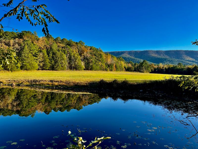
I experienced this firsthand when morning fog filled the valleys below the ridgeline, creating an ocean of clouds with mountain peaks rising like islands.
These temperature inversions occur frequently during spring and fall when cool overnight air settles in the valleys while ridgetops remain clear. The effect is absolutely stunning and makes for incredible photography opportunities.
I arrived at an overlook just after sunrise and watched the fog slowly burn off as the sun warmed the valleys.
Summer thunderstorms rolling through the mountains create dramatic cloud formations and shafts of sunlight breaking through. I witnessed one such storm from a safe overlook and watched rain curtains moving across distant ridges.
The changing light painted the landscape in constantly shifting colors.
Winter occasionally brings light snow to the highest elevations, transforming the byway into a winter wonderland. Ice can make the road treacherous, though, so check conditions before attempting a winter drive.
The road sometimes closes temporarily during severe weather.
Whatever season you visit, the atmospheric conditions will likely enhance your experience in unexpected ways.
Motorcycle Riders Celebrate the Curves and Vistas
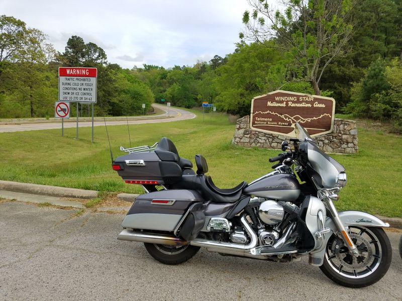
The Talimena National Scenic Byway ranks among the most popular motorcycle routes in Oklahoma and the surrounding region. The combination of smooth pavement, sweeping curves, minimal traffic, and spectacular scenery creates an ideal riding experience.
I shared the road with numerous motorcyclists during my visit, from solo riders to large touring groups.
The road design includes gentle curves that flow naturally with the mountain topography. Engineers built this route specifically as a scenic parkway, so the curves are banked appropriately and sight lines are generally excellent.
This makes for enjoyable, safe riding when you maintain appropriate speeds.
Many motorcyclists time their rides to coincide with the October foliage festival, creating a massive gathering of bikes along the route. I spoke with several riders who make this pilgrimage annually, some traveling from several states away.
The camaraderie among riders was evident at every overlook.
If you’re riding rather than driving, remember that the elevation changes and curves require attention and appropriate speed. Wildlife crossings are common, especially near dawn and dusk.
The experience of riding through these mountains with nothing between you and the views except open air is genuinely unforgettable.
Several motorcycle-friendly accommodations near both ends of the byway cater specifically to riders.
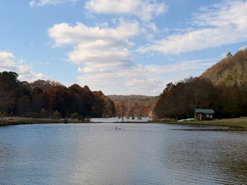
Camping Options Let You Experience Multiple Sunrises
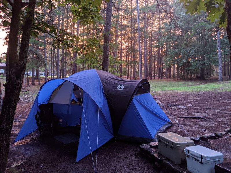
Spending a night or two camping near the Talimena National Scenic Byway allows you to experience the mountains at different times of day and catch both sunrise and sunset from the overlooks. Several campgrounds operated by the U.S.
Forest Service provide developed camping facilities along or near the route.
I stayed at one of these campgrounds and found it well-maintained with clean facilities, picnic tables, and fire rings. The campground sat nestled in the forest, providing a peaceful atmosphere with sounds of nature replacing city noise.
I slept better than I had in months, lulled by the breeze through the trees.
More adventurous visitors can pursue dispersed camping in the Ouachita National Forest, following Leave No Trace principles. This requires more preparation and self-sufficiency but offers greater solitude and flexibility.
I met several backpackers who were camping along the Ouachita Trail and exploring different sections of the byway each day.
Morning at the campground brought a chorus of birdsong and the chance to reach overlooks for sunrise before most day-trippers arrived. I drove to a nearby vista just as the sun broke over the eastern ridges, painting the valleys in golden light.
That moment alone justified camping rather than staying in town.
Dear Reader: This page may contain affiliate links which may earn a commission if you click through and make a purchase. Our independent journalism is not influenced by any advertiser or commercial initiative unless it is clearly marked as sponsored content. As travel products change, please be sure to reconfirm all details and stay up to date with current events to ensure a safe and successful trip.