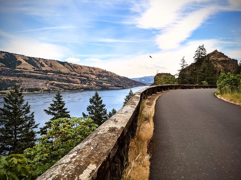
Oregon’s winding mountain drive doesn’t waste a single inch of scenery. I hit the road and immediately get pulled into curves that feel like they were designed for maximum “wow” moments.
Spring foliage explodes across the landscape, painting the hills in greens, golds, and bursts of color. Every turn opens up a new view that makes you slow down just a little more than you planned.
Locals treat it like a familiar weekend escape, while I’m constantly reaching for the camera like it’s my first time seeing nature.
Even the quiet stretches between viewpoints feel alive, like the mountains are setting the pace.
I end the drive a little breathless, already convinced this route deserves a repeat run.
The History Behind the Highway
Built between 1913 and 1922, the Historic Columbia River Highway was America’s first scenic highway. Samuel Lancaster, a civil engineer, designed it to blend into the natural landscape rather than fight against it.
He wanted drivers to feel like guests, not conquerors.
The road follows ancient travel routes used by Indigenous peoples for thousands of years. When it opened, it was considered an engineering marvel.
Bridges, tunnels, and stone guard walls were all crafted by hand with incredible care.
Today, it is listed on the National Register of Historic Places. The highway is also a National Historic Landmark and part of the Historic Columbia River Highway State Trail.
Knowing this history makes every curve feel more meaningful. You are not just driving a road.
You are rolling through a century of American adventure and ambition, and that feeling is hard to shake once it settles in.
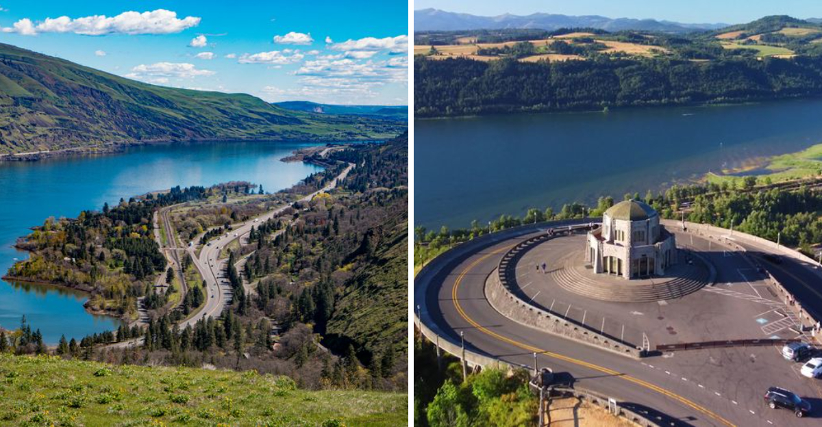
Crown Point and Vista House
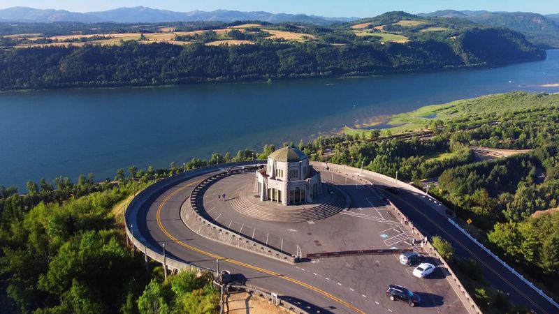
Crown Point is the kind of place that makes you forget to breathe. Perched 733 feet above the Columbia River, it offers a panoramic view that stretches for miles in every direction.
Vista House sits right at the edge, a small but striking stone building completed in 1918.
I pulled over here on a clear spring morning and just stood there. The river below looked like hammered silver.
Wildflowers were already blooming in patches along the cliff edge.
Vista House was built as a rest stop and memorial to Oregon pioneers. Inside, you will find exhibits about the highway’s history and a small gift area.
The architecture itself is worth studying. Its octagonal shape and Art Nouveau details are surprisingly elegant for a roadside stop.
Rangers are often on hand to answer questions. Arrive early in spring to avoid crowds and catch the soft morning light painting everything golden.
This spot alone is worth the entire drive.
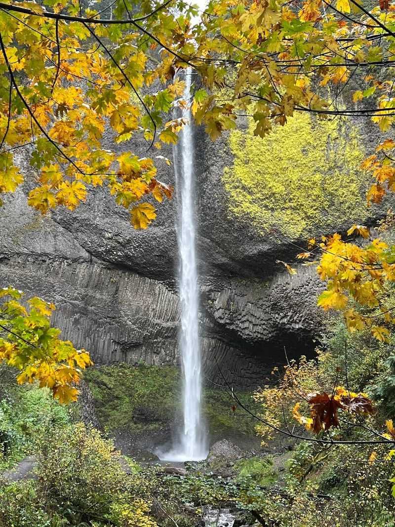
Multnomah Falls Up Close
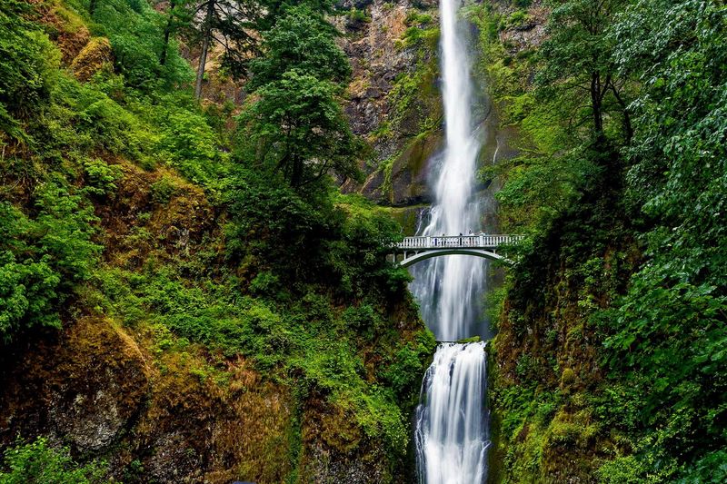
Multnomah Falls is Oregon’s most visited natural attraction, and honestly, the hype is fully earned. The waterfall drops 620 feet in two tiers, crashing into a pool surrounded by mossy rock and ancient ferns.
In spring, the flow is at its most powerful.
The mist hits your face before you even reach the bridge. That iconic Benson Bridge spans the falls midway up and gives you a view that feels almost unreal.
I stood there long enough to get my jacket damp, and I did not care one bit.
A trail continues from the bridge all the way to the top of the falls for those who want a workout with their scenery. The hike is about 2.2 miles round trip with significant elevation gain.
The Historic Columbia River Highway runs right past the falls trailhead. Parking fills fast in spring, so arriving before 9 a.m. is a smart move.
The shuttle from Portland is also a solid option on busy weekends.
Latourell Falls and Its Basalt Canvas
Latourell Falls might be the most underrated stop on the entire highway. The waterfall drops nearly 250 feet in a single dramatic plunge against a massive basalt wall covered in vivid yellow lichen.
The color contrast is genuinely startling.
Most people rush past it on their way to Multnomah, and that is their loss. The short loop trail here takes less than an hour and rewards you with two waterfall viewpoints.
Spring adds a layer of green so rich it almost looks artificial.
The basalt columns behind the falls formed millions of years ago during volcanic activity. Standing in front of them gives you a real sense of deep geological time.
Guy W. Talbot State Park surrounds the area and keeps the environment well protected.
There are picnic tables near the trailhead if you want to linger. Pack a light snack and sit beside the creek for a few minutes.
The sound of rushing water here is genuinely calming in a way that words struggle to capture.
Spring Wildflowers Along the Route
Spring transforms Hwy 30 into something close to magical. From late March through May, wildflowers bloom in waves along the hillsides and open meadows.
Balsamroot, with its bright yellow petals, is one of the first to appear.
Camas flowers follow shortly after, painting slopes in shades of violet and blue. Native lupine, paintbrush, and phlox add even more variety as the season progresses.
The color combinations against the dark basalt cliffs are genuinely striking.
Tom McCall Preserve near Rowena Crest is one of the best spots to see wildflower displays. The plateau blooms spectacularly each spring.
Trails wind through the open grasslands and offer views of the river far below. I walked those trails in late April and counted at least a dozen different flower species within the first quarter mile.
Spring timing varies slightly each year depending on rainfall and temperature. Checking with the Columbia River Gorge National Scenic Area office can help you plan your visit for peak bloom.
It is absolutely worth timing correctly.
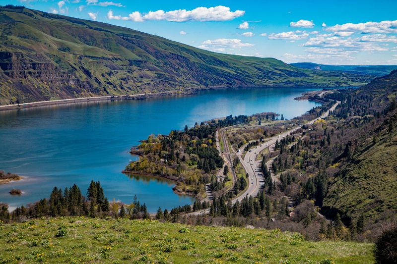
Rowena Crest Viewpoint
Rowena Crest is one of those viewpoints that makes your stomach drop in the best way. The road winds up in tight hairpin curves, and then suddenly the world opens wide.
The Columbia River stretches out below, and the landscape shifts from dense forest to open plateau.
This is where the highway transitions from the wet western side of the Gorge to the drier eastern side. The change happens fast.
One moment you are surrounded by Douglas fir, and the next you are standing on a windswept bluff above golden grasslands.
The viewpoint sits right where US-30 and Historic Columbia River Highway intersect near Rowena, OR 97058. Parking is available at the top, and the overlook requires almost no walking.
It is accessible and rewarding for visitors of all ages and abilities. On a clear spring day, you can see Mount Hood and Mount Adams from this single spot.
That view alone is the kind of thing you think about for weeks after the drive is done.
The Waterfalls Trail Corridor
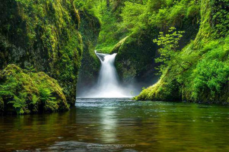
Between Troutdale and Ainsworth State Park, the highway passes more waterfalls per mile than almost anywhere else in the country. This stretch is sometimes called the Waterfall Corridor, and it earns that name easily.
Bridal Veil, Wahkeena, Horsetail, and Oneonta all appear along this route.
Each waterfall has its own personality. Horsetail Falls spills right beside the road, close enough to feel the mist from your car window.
Oneonta Gorge requires a short wade through a narrow slot canyon to reach its hidden falls.
Spring runoff makes every single one of them louder and more dramatic. The sound layers on top of itself as you move from one to the next.
Hiking between them on the Gorge Trail is possible for those who want to stretch their legs. The trail connects several waterfalls and passes through old-growth forest sections.
Mossy logs, fern-covered banks, and the constant sound of rushing water make this corridor feel ancient. It is a sensory experience that no photograph fully prepares you for.
Historic Tunnels and Stone Bridges
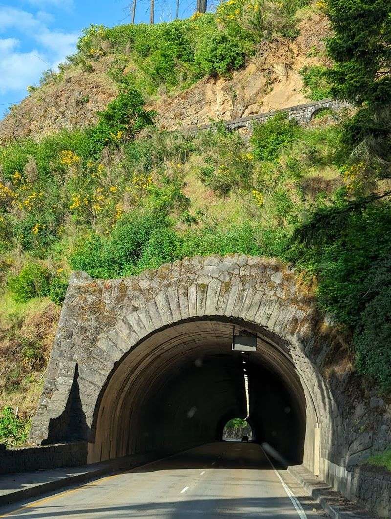
One of the most charming engineering details of Hwy 30 is the series of hand-built stone tunnels and bridges that dot the route. These structures were carved and assembled by workers over a century ago.
They feel more like European countryside architecture than anything you expect to find in the American Pacific Northwest.
The tunnels are low and narrow by modern standards, which adds to their old-world character. Driving through one feels like passing through a portal to an earlier era.
The stone walls are thick with moss and age.
The bridges, many of them spanning deep ravines and creek gorges, were built using locally quarried basalt. Samuel Lancaster insisted on craftsmanship that would stand for generations, and he was right.
Many of these structures are still in their original form. Stopping to photograph one of the smaller bridges with spring greenery framing it makes for a genuinely beautiful image.
These details remind you that this highway was always meant to be more than just transportation. It was meant to be an experience.
Larch Mountain Road Detour
Just off the main highway, Larch Mountain Road offers one of the best detour decisions you can make on this drive. The road climbs steeply through dense old-growth forest, winding upward for about 14 miles from the valley floor.
At the top, a short trail leads to Sherrard Point.
Sherrard Point delivers a summit view that includes five major Cascade volcanoes on a clear day. Mount Hood, Mount Adams, Mount Rainier, Mount St. Helens, and Mount Jefferson all appear at once.
Spring visits mean snow may still linger near the summit, adding drama to the panorama.
The forest along the road itself is spectacular. Massive Douglas firs and western red cedars line the route, their canopies filtering light into shifting patterns on the pavement.
Wildlife sightings are common here in spring. Deer, elk, and various bird species are active as the season warms.
The road is typically open from late spring through fall. Checking road conditions before heading up is always a smart call on this particular stretch of the journey.
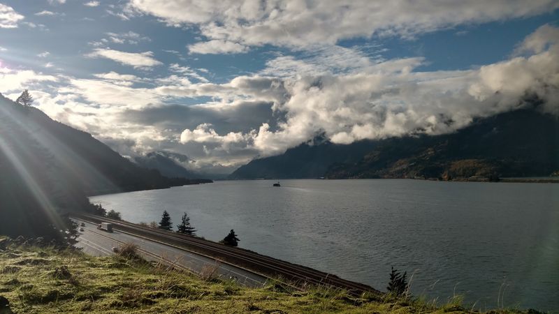
Planning Your Drive on Hwy 30
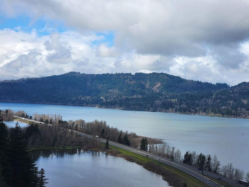
Getting the most out of Hwy 30 takes a little planning, and it is genuinely worth the effort. The full scenic highway runs about 70 miles from Troutdale to The Dalles.
Most visitors focus on the western section, which holds the majority of waterfalls and viewpoints.
Spring, from mid-March through May, is widely considered the best season. Waterfalls are at peak flow, wildflowers are blooming, and the green is almost impossibly vivid.
Weekday visits help avoid the heavy weekend crowds that gather at popular stops.
The highway is two lanes and winds tightly in many sections, so slow down and enjoy the pace. Pullouts and viewpoints appear regularly and are clearly marked.
Cell service can be spotty in some areas, so downloading an offline map beforehand is a good idea. Wear layers, since temperatures change quickly as you gain and lose elevation throughout the drive.
The nearest major hub is Portland, about 30 minutes west of the scenic section.
Dear Reader: This page may contain affiliate links which may earn a commission if you click through and make a purchase. Our independent journalism is not influenced by any advertiser or commercial initiative unless it is clearly marked as sponsored content. As travel products change, please be sure to reconfirm all details and stay up to date with current events to ensure a safe and successful trip.