Vermont is home to some of the most breathtaking backroads in all of New England.
These winding routes take you through dense forests, past historic covered bridges, over mountain passes, and along sparkling lakeshores.
Whether you’re chasing fall foliage or simply seeking a peaceful escape from the everyday rush, Vermont’s backroads deliver unforgettable views and a true sense of adventure.
Each route has its own personality, from the dramatic cliffs of mountain notches to the gentle curves of valley roads lined with working farms.
Some paths are paved and smooth, perfect for a leisurely Sunday drive, while others are rugged dirt tracks that lead to hidden gems only locals know about.
No matter which one you choose, you’ll find charming small towns, roadside farm stands, and countless spots to pull over and soak in the natural beauty.
Get ready to discover ten incredible backroads that showcase the very best of what this beautiful state has to offer.
1. Route 100 (The Skier’s Highway)
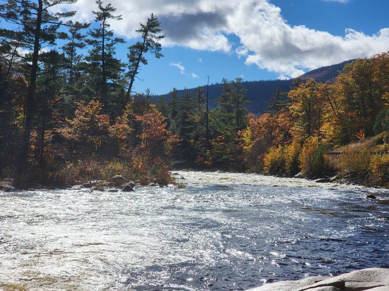
Route 100 stretches nearly the entire length of Vermont from north to south, earning its reputation as one of the most scenic drives in New England.
This legendary highway weaves through charming villages, past working farms, and alongside pristine mountain streams.
Travelers can access multiple ski resorts along the way, making it a year-round destination for outdoor enthusiasts.
Natural wonders like Moss Glen Falls are just a short detour from the main road, offering perfect spots for photography and picnics.
Small towns dot the route, each with its own character and local flavor, from antique shops to farm-to-table restaurants.
The highway climbs gently through the Green Mountains, providing sweeping vistas at nearly every turn.
During autumn, the foliage transforms the landscape into a kaleidoscope of reds, oranges, and golds that draw visitors from around the world.
Winter blankets the route in snow, creating a peaceful, almost magical atmosphere perfect for a quiet drive.
Spring brings wildflowers and rushing waterfalls as snowmelt feeds the rivers and streams.
Summer offers lush greenery and warm sunshine ideal for stopping at roadside stands selling fresh Vermont maple syrup and local produce.
Route 100 connects communities and showcases the authentic spirit of rural Vermont life.
Address: Route 100, Vermont (runs from Readsboro to Newport)
2. Smugglers’ Notch Road (Route 108)
Smugglers’ Notch Road cuts a dramatic path through the heart of the Green Mountains between Stowe and Jeffersonville.
Towering cliffs rise on both sides of this narrow, winding pass, creating an almost tunnel-like effect that feels both thrilling and humbling.
The road earned its colorful name from its history as a smuggling route during the early nineteenth century.
Dense forests surround the route, offering shade in summer and spectacular color displays when fall arrives.
Because of heavy snowfall and challenging conditions, the road closes from late autumn through late spring, typically November to May.
When open, it provides access to excellent hiking trails that lead to caves, waterfalls, and panoramic mountain views.
The tight curves and steep grades make this drive an adventure, requiring careful attention and slow speeds.
Pullouts along the way allow drivers to stop safely and admire the unique rock formations carved by glaciers thousands of years ago.
Wildlife sightings are common, with deer, wild turkeys, and occasionally moose appearing near the roadside.
The notch itself sits at a high elevation, where temperatures can be noticeably cooler than in the valleys below.
This route captures the wild, rugged beauty that Vermont is famous for.
Address: Route 108, Stowe to Jeffersonville, Vermont
3. Molly Stark Scenic Byway (Route 9)
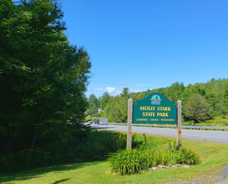
Molly Stark Scenic Byway travels east to west across southern Vermont, connecting Brattleboro and Bennington through some of the state’s most beautiful terrain.
Named after the wife of Revolutionary War General John Stark, the route carries a rich historical legacy.
The byway passes directly through the Green Mountain National Forest, where dense woodlands give way to occasional clearings with stunning mountain vistas.
Historic villages along the route preserve the architectural charm and small-town feel that define Vermont.
One of the highlights is the Hogback Mountain Country Store, famous for its panoramic overlook that reportedly stretches for a hundred miles on clear days.
From this vantage point, you can see rolling hills, distant peaks, and valleys that seem to go on forever.
The route climbs and descends through several mountain passes, each offering its own unique perspective on the landscape.
Roadside attractions include local craft shops, historic markers, and trailheads leading into the national forest.
Autumn transforms the byway into one of the most photographed roads in Vermont, as the hardwood forests explode with color.
Wildlife is abundant, and patient observers might spot hawks soaring overhead or deer grazing in meadows.
The combination of natural beauty and historical significance makes this route truly special.
Address: Route 9, Brattleboro to Bennington, Vermont
4. The Champlain Islands (Route 2)
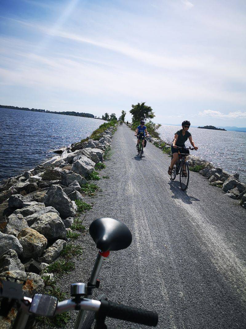
Route 2 takes you on a unique journey through the Champlain Islands, offering a completely different experience from Vermont’s mountain roads.
North of Burlington, the highway hops from island to island via causeways and bridges, with Lake Champlain surrounding you on both sides.
The views are expansive and open, with water stretching to the horizon and New York’s Adirondack Mountains rising dramatically in the distance.
This relatively flat drive feels almost coastal, a surprising contrast to the rugged peaks found elsewhere in the state.
Charming island communities welcome visitors with local shops, farm stands, and lakeside parks perfect for picnics.
The islands have a relaxed, unhurried vibe that invites you to slow down and savor the scenery.
Sunsets over the lake are particularly spectacular, painting the sky in shades of pink, orange, and purple.
Cycling is popular here thanks to the gentle terrain and scenic beauty, with designated bike paths and quiet roads.
Marinas dot the shoreline, and sailboats glide across the water on breezy summer days.
Birdwatchers flock to the islands to observe migrating waterfowl and other species that inhabit the wetlands.
The route offers a peaceful escape with a distinct character unlike any other drive in Vermont.
Address: Route 2, Champlain Islands, Vermont (from South Hero to North Hero and beyond)
5. Mad River Byway (Routes 100 and 100B, Route 17)
Mad River Byway winds through one of Vermont’s most picturesque valleys, following the Mad River as it tumbles over rocks and through forested gorges.
The route passes through the charming towns of Waitsfield and Warren, both known for their vibrant local culture and welcoming communities.
Mountain views dominate the landscape, with peaks rising steeply on either side of the valley floor.
Warren Falls is a popular swimming hole where locals and visitors alike cool off during the hot summer months.
The historic Waitsfield Covered Bridge spans the river, offering a perfect photo opportunity and a glimpse into Vermont’s past.
Farm fields and pastures line the roadside, with grazing cattle and horses adding to the pastoral charm.
The byway is especially popular with cyclists, who appreciate the scenic beauty and manageable hills.
Local restaurants and cafes in the valley towns serve farm-fresh cuisine that highlights Vermont’s agricultural bounty.
Art galleries and craft studios showcase the work of talented local artisans, from pottery to handwoven textiles.
During winter, the valley becomes a hub for skiing and snowboarding, with major resorts just minutes away.
The combination of natural beauty, outdoor recreation, and small-town charm makes this byway a favorite among both residents and visitors.
Address: Routes 100, 100B, and 17, Mad River Valley, Vermont (Waitsfield and Warren area)
6. Stone Valley Scenic Byway (Route 30)
Stone Valley Scenic Byway follows Route 30 from Manchester to Hubbardton, cutting through a valley famous for its slate and marble quarrying heritage.
The Taconic Mountains rise to the west, their forested slopes providing a stunning backdrop to the pastoral landscape below.
Historic stone buildings and walls built from local materials line the route, testament to the region’s industrial past.
Lake Bomoseen and Lake St. Catherine offer opportunities for swimming, boating, and fishing, with public access points along the way.
The byway passes through small villages where time seems to move a little slower, and neighbors still wave as you drive by.
Antique shops and country stores invite exploration, filled with treasures ranging from vintage tools to handmade quilts.
The valley floor is relatively flat, making for easy driving with gentle curves and long straightaways.
Agricultural fields and orchards line the roadside, producing everything from apples to sweet corn.
During harvest season, farm stands overflow with fresh produce, baked goods, and locally made maple products.
The route is less traveled than some of Vermont’s more famous roads, offering a peaceful, uncrowded experience.
Historic markers along the way tell stories of early settlers and the industries that shaped the region.
Address: Route 30, Manchester to Hubbardton, Vermont
7. Darling Hill Road (Northeast Kingdom)
Darling Hill Road near Lyndonville represents the quintessential Vermont backroad experience, with its unpaved surface and breathtaking rural scenery.
Rolling hills covered in meadows and woodlands create a patchwork landscape that changes with the seasons.
Burke Mountain rises in the distance, providing a dramatic focal point for photographers and nature lovers.
The Willoughby Gap, a distinctive notch in the mountain range, adds to the visual drama of the panoramic views.
This dirt road meanders gently, following the natural contours of the land rather than cutting straight through it.
Old farmhouses and barns dot the hillsides, many still in use by working farms that have been in families for generations.
The road is especially popular during foliage season when the hardwood forests turn brilliant shades of red, orange, and gold.
Open meadows allow for unobstructed views across the valley and toward the surrounding peaks.
Wildlife is abundant, with deer, wild turkeys, and songbirds frequently spotted along the roadside.
The quiet, peaceful atmosphere makes this an ideal escape from busier tourist routes.
Local residents take pride in maintaining the rural character of the area, preserving its natural beauty for future generations.
Address: Darling Hill Road, Lyndonville, Vermont
8. Hazen’s Notch Road (Route 58)
Hazen’s Notch Road traverses one of Vermont’s most remote and rugged mountain passes, connecting Westfield and Montgomery Center through pristine wilderness.
Route 58 includes unpaved sections that add to the adventure, requiring careful driving but rewarding you with spectacular scenery.
Jay Peak dominates the northern horizon, its distinctive profile recognizable from miles away.
The road climbs steadily through dense forests of spruce and fir, with occasional clearings offering glimpses of the surrounding mountains.
Old sugarhouses stand as reminders of Vermont’s maple syrup tradition, some still in use during sugaring season.
Hiking trails branch off from the main road, leading to waterfalls, mountain summits, and quiet forest glades.
The notch itself is a narrow gap between steep mountain slopes, creating a sense of isolation and wilderness.
Because of heavy snow and difficult winter conditions, the road closes seasonally, typically from late autumn through spring.
When open, it provides access to some of the most unspoiled landscapes in the Northeast Kingdom.
Wildlife sightings are common, including moose, black bears, and various bird species that thrive in the remote forest.
The lack of development along the route enhances the feeling of stepping back in time to a wilder Vermont.
Address: Route 58, Westfield to Montgomery Center, Vermont
9. Jenne Road (near Woodstock)
Jenne Road in Reading is a short but incredibly scenic dirt road that leads to one of the most photographed farms in all of New England.
The historic Jenne Farm sits at the end of the road, its red barn and white farmhouse creating a picture-perfect composition against the backdrop of rolling hills.
Photographers from around the world make the pilgrimage here, especially during fall foliage season when the landscape explodes with color.
The farm remains a working property, so visitors are asked to respect the privacy of the residents and view from the road.
The drive itself is peaceful and quiet, winding through open pastures and past stone walls that mark old property boundaries.
Sheep and cattle often graze in the fields, adding to the bucolic charm of the scene.
The road is short enough to explore on foot, making it popular with walkers and nature lovers seeking a gentle stroll.
Morning and evening light create particularly beautiful conditions for photography, with long shadows and warm tones.
The surrounding countryside offers additional scenic views, with mountain ridges visible in every direction.
This area captures the essence of Vermont’s agricultural heritage and natural beauty in a compact, accessible package.
Nearby Woodstock provides dining and lodging options for those wanting to explore the region further.
Address: Jenne Road, Reading, Vermont (near Woodstock)
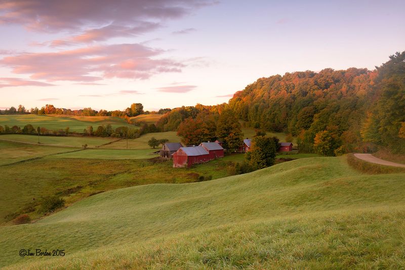
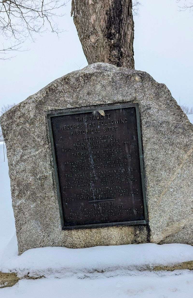
10. Peacham and Groton Loop (including Bayley-Hazen Road)
The Peacham and Groton Loop takes you through some of the most picturesque towns in Vermont, including Danville and Peacham, both known for their pristine village greens and historic architecture.
Groton State Forest dominates much of the route, offering access to numerous ponds, hiking trails, and campgrounds.
The loop includes a section of the historic Bayley-Hazen Road, a military road dating back to the Revolutionary War.
This ancient route was originally intended to facilitate troop movements but now serves as a fascinating historical attraction.
Peacham village is particularly famous for its white church steeple and surrounding hills, a scene that has graced countless calendars and postcards.
The town’s elevated position provides sweeping views across the surrounding valleys and mountains.
Several pristine ponds within the state forest offer swimming, fishing, and peaceful spots for reflection.
The forest roads wind through dense woodlands where moose and deer are frequently spotted.
Autumn brings spectacular foliage, with the hardwood forests creating a tapestry of brilliant colors.
Local general stores in the villages serve as community gathering places, offering provisions and friendly conversation.
The loop can be driven in a few hours but deserves a full day to fully appreciate the natural beauty and historical significance.
Address: Loop through Peacham, Danville, and Groton State Forest, Vermont
Dear Reader: This page may contain affiliate links which may earn a commission if you click through and make a purchase. Our independent journalism is not influenced by any advertiser or commercial initiative unless it is clearly marked as sponsored content. As travel products change, please be sure to reconfirm all details and stay up to date with current events to ensure a safe and successful trip.