Think the interstate is your only option for getting from point A to point B in Virginia? Think again.
The Old Dominion is laced with winding byways, mountain crests, and coastal crossings that turn every trip into an adventure worth savoring. Forget the monotony of mile markers and rest stops.
These routes offer overlooks that’ll make you pull over just to catch your breath, historic sites that bring textbooks to life, and curves that remind you why driving can be pure joy. Whether you’re chasing fall foliage, escaping the city grind, or just craving a change of scenery, Virginia’s backroads deliver experiences no highway ever could.
1. Skyline Drive at Shenandoah National Park, Virginia
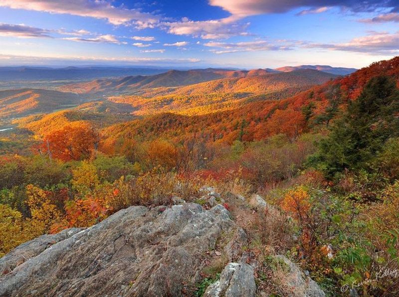
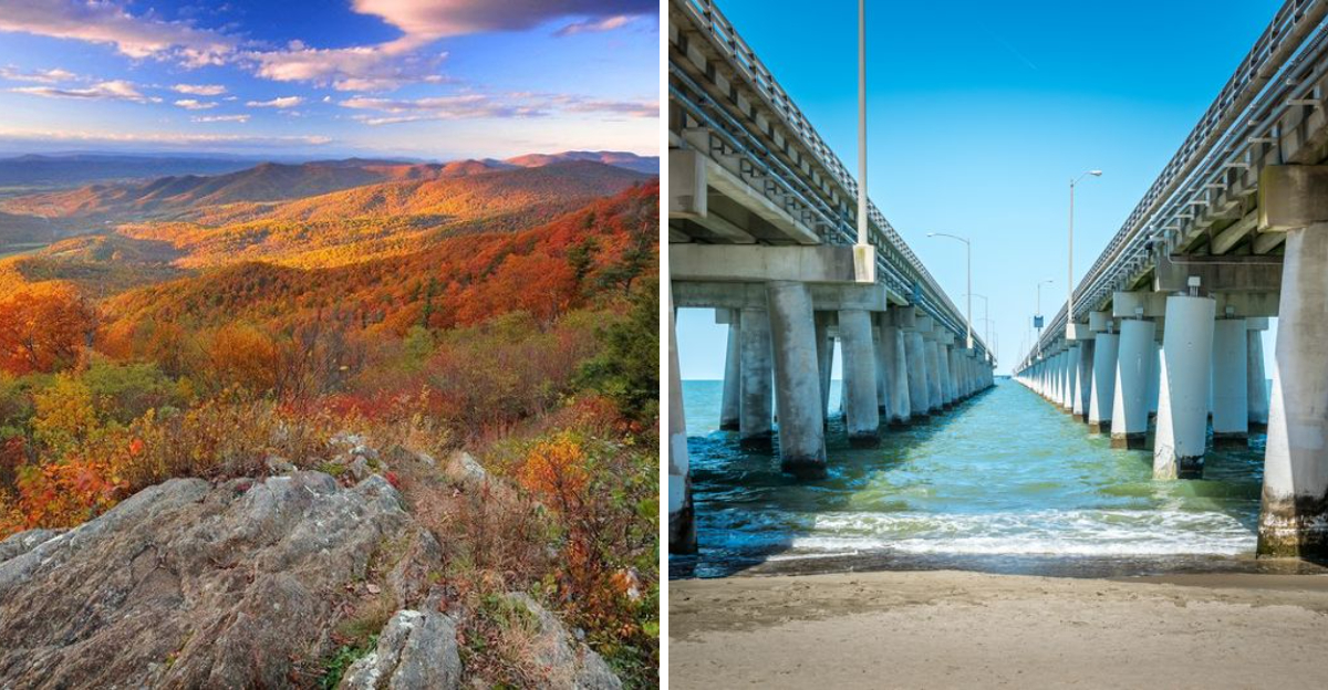
Rolling along the spine of the Blue Ridge Mountains, this legendary route stretches for 105 miles of pure visual candy. Every twist and turn reveals another reason to slow down, pull off, and soak in the kind of views that make you forget about your destination entirely.
Seventy-five overlooks punctuate the journey, each offering its own slice of Shenandoah magic. The Point serves up panoramic mountain vistas that seem to ripple endlessly into the horizon.
Hogback Overlook catches the sunset like nowhere else, painting the sky in shades that cameras can never quite capture.
Wildlife sightings add spontaneous thrills to the drive. Black bears amble across the road with surprising frequency during summer months.
White-tailed deer graze in meadows visible from countless pullouts. Hawks circle overhead, riding thermals that rise from the valley floor.
Spring carpets the roadside with wildflowers and fresh green canopy. Summer brings lush forests and cool mountain breezes that make the drive a natural air-conditioned escape.
Fall transforms the entire parkway into a kaleidoscope of reds, oranges, and golds that draw leaf-peepers from across the country.
Winter offers its own stark beauty, though portions may close during severe weather. The bare trees reveal rock formations and distant ridgelines hidden during leafier seasons.
Crisp air and occasional snow dustings create a serene atmosphere perfect for contemplative cruising.
Address: Shenandoah National Park, Virginia 22835
2. Blue Ridge Parkway, Virginia
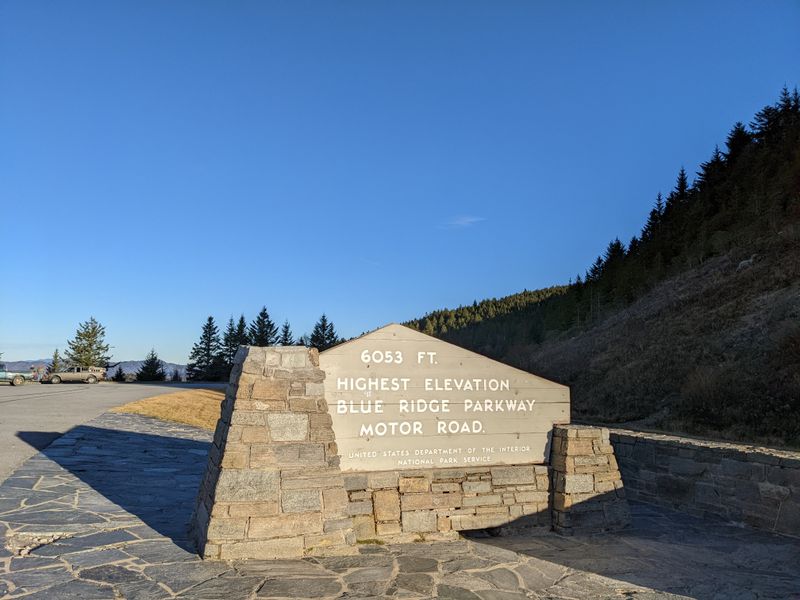
America’s most beloved driving experience winds its way through Virginia’s southwestern corner, delivering postcard moments at practically every milepost. This isn’t just a road connecting two points.
It’s a carefully crafted ribbon of asphalt designed specifically to showcase the Southern Appalachians at their finest.
Starting near Waynesboro, the parkway curves southward through landscapes that shift with elevation and season. Dense forests give way to open meadows.
Mountain balds offer 360-degree views that stretch into multiple states on clear days.
Mabry Mill stands as the parkway’s most photographed landmark around milepost 176. The weathered wooden structure sits beside a glassy pond, its reflection creating picture-perfect symmetry.
It’s a glimpse into mountain life from generations past, when water-powered mills ground grain for entire communities.
Peaks of Otter rewards drivers willing to venture to higher elevations. The air grows noticeably cooler as you climb.
Views expand exponentially. Sharp Peaks jut dramatically against the sky, creating silhouettes that change character throughout the day.
Roadside trails invite impromptu hikes ranging from five-minute strolls to full-day adventures. Waterfalls tumble down moss-covered rocks just steps from parking areas.
Wildflower meadows explode with color during late spring and early summer.
The parkway maintains a strict ban on commercial development, meaning no billboards, gas stations, or fast-food joints interrupt the natural scenery. It’s just you, the road, and the mountains.
Address: Blue Ridge Parkway, Waynesboro, VA 22980
3. Colonial Parkway, Virginia
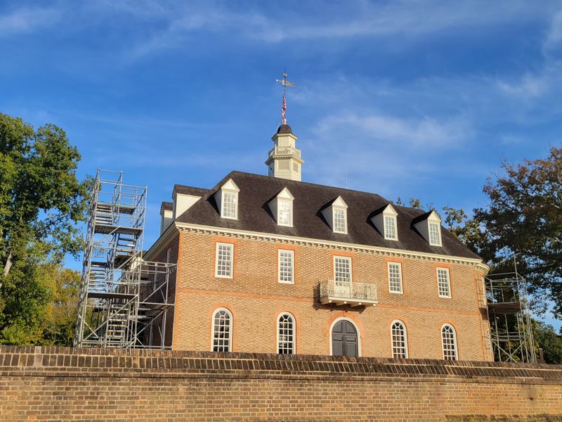
Step into a time machine disguised as a scenic byway. This 23-mile stretch connects three cornerstones of American history without a single traffic light or commercial billboard to break the spell.
The stone-paved surface adds a tactile element that modern highways completely lack.
Jamestown marks one end of this historic corridor, where English colonists first established a permanent settlement. The parkway then winds through forests and wetlands toward Williamsburg, where costumed interpreters still recreate colonial life with remarkable authenticity.
Yorktown anchors the opposite end, site of the decisive Revolutionary War battle that secured American independence.
Between these famous endpoints, the parkway hugs the James and York rivers, offering water views that shift with tides and seasons. Marshlands teem with herons, egrets, and other wading birds.
Sailboats glide past on breezy afternoons. Sunsets reflect off the water in shimmering copper and gold.
What makes this drive truly special is what’s missing. No fast-food chains.
No strip malls. No garish signage competing for attention.
Just trees, water, and history stretching back over four centuries.
The parkway’s design intentionally evokes earlier eras, with stone bridges and rustic overlooks that blend seamlessly into the landscape. Cyclists share the road on weekends, taking advantage of the relatively flat terrain and light traffic.
Spring brings cherry blossoms and dogwood blooms that frame the historic sites in natural beauty. Fall foliage creates a colorful backdrop for exploring Virginia’s colonial past at a pace that actually allows appreciation.
Address: Colonial Parkway, Williamsburg, VA 23185
4. Back of the Dragon on Route 16, Virginia
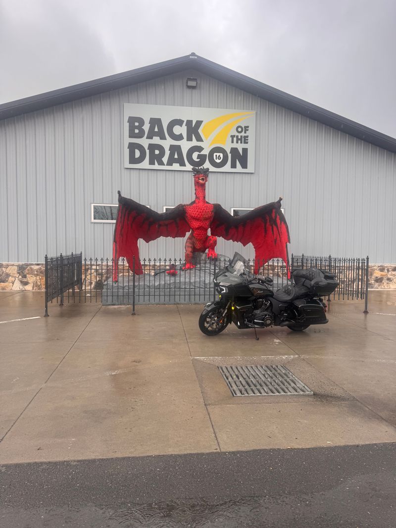
Motorcyclists and driving enthusiasts speak of this route in reverent tones, like surfers discussing a legendary wave. Thirty-two miles between Marion and Tazewell pack 438 curves across three distinct mountain ranges.
This isn’t a drive for the timid or distracted.
The nickname comes honestly. This serpentine stretch twists and turns with the relentless intensity of a dragon’s spine.
Hairpin curves demand full attention and smooth steering. Elevation changes add vertical drama to the horizontal gymnastics.
Unlike some scenic drives that prioritize gentle cruising, Back of the Dragon rewards skill and engagement. Every curve presents a new challenge and opportunity.
The road surface generally stays in good condition, allowing confident drivers to fully appreciate the engineering and geography.
Mountain vistas appear suddenly as you crest ridges, then disappear just as quickly as you descend into forested valleys. The constant change keeps senses engaged and eliminates any possibility of highway hypnosis.
Spring and fall attract the biggest crowds, with riders traveling from multiple states specifically for this experience. Summer offers lush greenery and comfortable temperatures at higher elevations.
Winter can bring ice and closures, making it strictly a warm-weather destination for most.
Small communities at either end provide fuel, food, and conversation with fellow road warriors. Local businesses have embraced the route’s reputation, offering motorcycle-friendly amenities and insider tips on timing and conditions.
This drive isn’t about leisurely sightseeing or frequent photo stops. It’s about the pure joy of piloting a vehicle through challenging terrain with skill and confidence.
Address: Route 16, Marion, VA 24354 to Tazewell, VA 24651
5. Chesapeake Bay Bridge Tunnel, Virginia
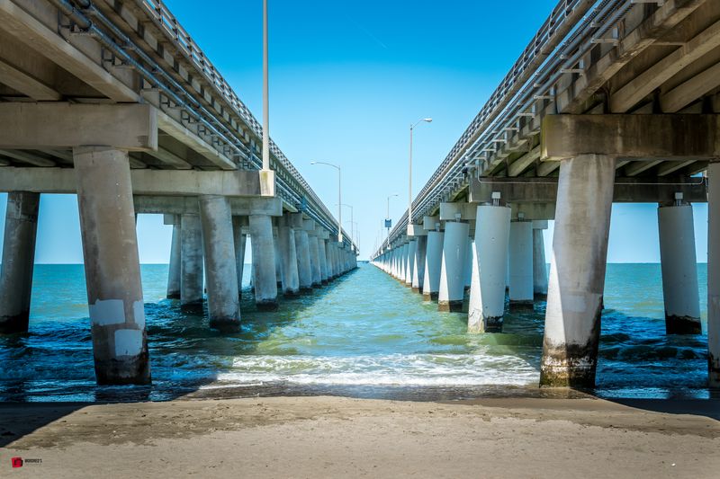
Part engineering marvel, part aquatic adventure, this 17-mile crossing redefines what a drive can be. You’re not just traveling over water.
You’re traveling through it, diving beneath ship channels via tunnels that put you in the middle of the Chesapeake Bay experience.
The journey begins on Virginia’s Eastern Shore, where the bridge gradually rises above coastal wetlands. Soon you’re suspended over open water with nothing but horizon in every direction.
Waves roll beneath. Seabirds wheel overhead.
Container ships pass in designated channels.
Then comes the surreal transition. The road descends into a tunnel, submerging beneath the bay to allow maritime traffic above.
Emerging on the other side feels like surfacing from a dive, with sunlight and open water greeting you once again.
Four artificial islands mark the tunnel portals, creating unexpected landmarks in the middle of the bay. These man-made structures have become havens for seabirds and fishing enthusiasts who arrive by boat.
Weather dramatically affects the experience. Calm days offer mirror-smooth water and unlimited visibility.
Stormy conditions bring whitecaps, spray, and an edge of adventure that heightens the crossing’s drama. Wind restrictions occasionally close the bridge-tunnel to high-profile vehicles.
The route serves practical purposes, connecting Virginia Beach to the Eastern Shore and eliminating hours of driving around the bay. But it’s become a destination itself, with travelers making the crossing purely for the unique experience.
Sunrise and sunset paint the water in spectacular colors. Dolphins sometimes surface near the bridge supports, adding wildlife encounters to the engineering spectacle.
Address: Chesapeake Bay Bridge Tunnel, Cape Charles, VA 23310
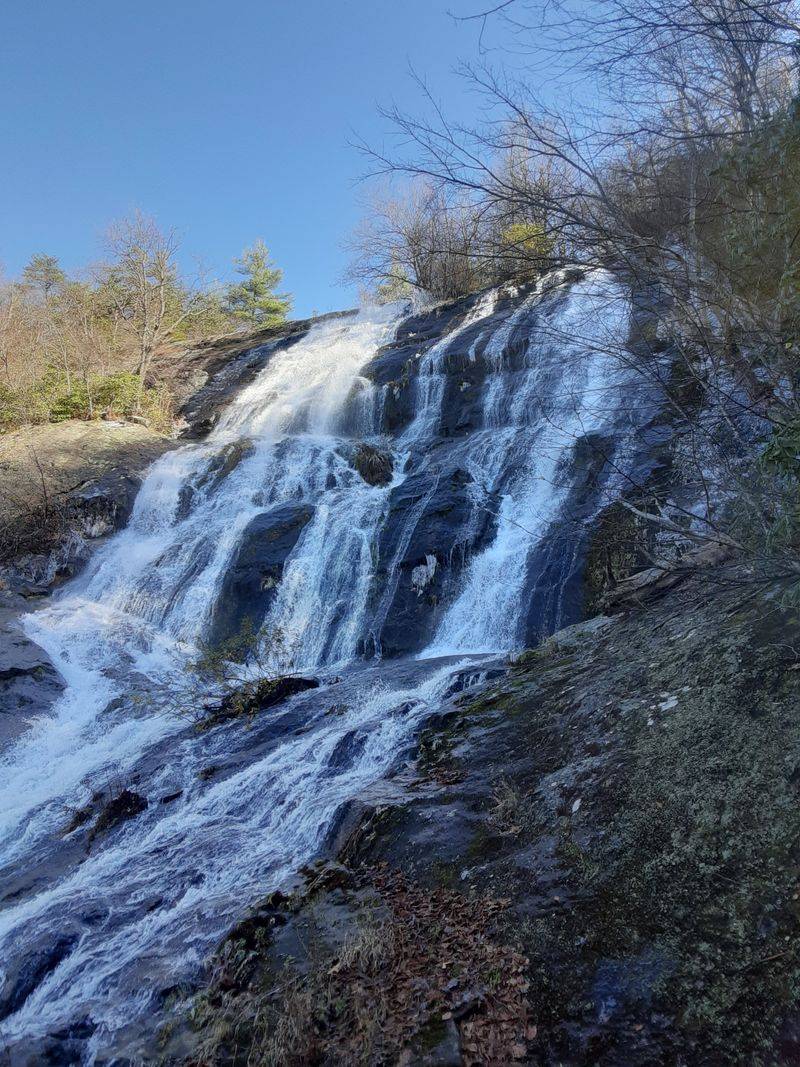
6. Nelson Scenic Loop, Virginia
Call it the greatest hits compilation of Virginia mountain experiences. This 50-mile circuit combines sections of the Blue Ridge Parkway with local roads that showcase Nelson County’s unique blend of natural beauty and craft beverage culture.
It’s a route designed for savoring, not rushing.
Crabtree Falls ranks among Virginia’s most spectacular cascades, dropping in a series of dramatic tiers. The trail to various viewpoints ranges from moderate to strenuous, but even a short walk rewards visitors with thundering water and misty spray.
Mountain wineries and breweries cluster throughout the region with remarkable density. Tasting rooms perch on hillsides with views that rival anything in Napa or Tuscany.
Many feature outdoor seating where visitors can enjoy beverages while soaking in mountain panoramas.
The loop’s elevation changes create distinct microclimates and ecosystems. Valley floors support different vegetation than ridge tops.
Temperature variations mean you might experience spring and fall conditions within the same afternoon drive.
Small towns along the route maintain authentic mountain character without excessive tourist development. General stores, family restaurants, and local shops provide provisions and conversation without corporate blandness.
Fall brings spectacular foliage that transforms the entire circuit into a photographer’s dream. Spring offers blooming orchards and wildflower meadows.
Summer provides cool mountain relief from lowland heat and humidity.
The loop works equally well in either direction, though clockwise routing saves some of the best parkway sections for the latter half. Allow a full day to properly explore, with time for stops, short hikes, and spontaneous detours.
Address: Nelson County Scenic Loop, Lovingston, VA 22949
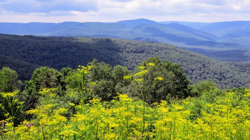
7. Highlands Scenic Byway, Virginia
Virginia’s Western Highlands remain refreshingly under-discovered compared to more famous mountain regions. This 19-mile loop between Clifton Forge and Lexington showcases exactly why that’s both surprising and fortunate.
Rugged terrain, minimal development, and authentic Appalachian character define every mile.
The byway climbs through elevation zones that create distinct visual chapters. Lower slopes support mixed hardwood forests that transition to evergreens at higher altitudes.
Open meadows appear unexpectedly, offering sweeping views across multiple ridges.
Unlike more manicured scenic drives, this route maintains a raw, unpolished quality that appeals to adventurous spirits. Gravel pullouts replace formal overlooks.
Wildlife sightings happen organically rather than at designated viewing areas. The experience feels discovered rather than packaged.
Historic sites dot the landscape, remnants of iron furnaces, logging operations, and mountain settlements that once thrived in these remote valleys. Interpretive signs provide context without overwhelming the natural setting.
The byway’s relative obscurity means light traffic even during peak seasons. You can drive for miles without encountering another vehicle, creating a sense of solitude increasingly rare on popular scenic routes.
Lexington anchors the eastern end with its well-preserved downtown, university atmosphere, and connections to Civil War history. Clifton Forge offers a different character, with railroad heritage and working-class authenticity that contrasts with more touristy mountain towns.
Four-season appeal keeps the loop interesting year-round. Spring brings rushing streams swollen with snowmelt.
Summer offers cool mountain temperatures and lush vegetation. Fall delivers reliable foliage without overwhelming crowds.
Winter transforms the highlands into stark, beautiful isolation.
Address: Highlands Scenic Byway, Clifton Forge, VA 24422 to Lexington, VA 24450
8. Lee Highway on Route 11, Virginia
Before Interstate 81 carved its efficient but sterile path through the Shenandoah Valley, Route 11 served as the main north-south artery. Locals still call it the Old Valley Pike, and driving it today reveals exactly what got lost when America prioritized speed over experience.
Small towns appear every few miles, each maintaining distinct character and history. Main streets feature locally owned businesses, historic buildings, and community gathering spots that chain-dominated highway exits can never replicate.
These aren’t tourist recreations but living communities that happen to welcome visitors.
Limestone caverns punctuate the valley, with several offering tours that descend into spectacular underground formations. These natural wonders formed over millions of years, creating cathedral-like chambers adorned with stalactites, stalagmites, and otherworldly rock features.
The highway parallels I-81 close enough to serve as a practical alternative but far enough to feel completely different. You’re trading ten minutes of travel time for an hour’s worth of genuine Shenandoah Valley atmosphere.
That’s a bargain most rushed travelers never realize exists.
Agricultural landscapes dominate between towns, with farms that have worked the same land for generations. Roadside stands sell seasonal produce, fresh cider, and homemade preserves.
Autumn brings pumpkin patches and corn mazes that draw families from throughout the region.
Valley views reveal the parallel mountain ranges that define this geographic corridor. The Alleghenies rise to the west.
The Blue Ridge stands guard to the east. Route 11 runs right down the middle, offering perspective on both.
Historic markers provide context about Civil War battles, pioneer settlements, and natural features. The valley’s strategic importance meant armies repeatedly marched these routes, leaving layers of history visible to observant travelers.
Address: Route 11 (Lee Highway), Shenandoah Valley, Virginia
Dear Reader: This page may contain affiliate links which may earn a commission if you click through and make a purchase. Our independent journalism is not influenced by any advertiser or commercial initiative unless it is clearly marked as sponsored content. As travel products change, please be sure to reconfirm all details and stay up to date with current events to ensure a safe and successful trip.