Virginia holds secrets beneath its rolling hills and lush forests, remnants of an industrial past that shaped the state’s history. Abandoned mines and quarries dot the landscape, silent witnesses to bygone eras of extraction and labor.
These forgotten places have transformed over time into stunning natural wonders, where rust meets wildflowers and still waters reflect the sky. What once echoed with pickaxes and machinery now hums with birdsong and rustling leaves, creating unexpectedly beautiful destinations for adventurous explorers.
Pack your camera and curiosity because Virginia’s industrial ruins offer picturesque backdrops that blend history with nature’s reclaiming power.
1. Gossan Lead Mine, Rockbridge County
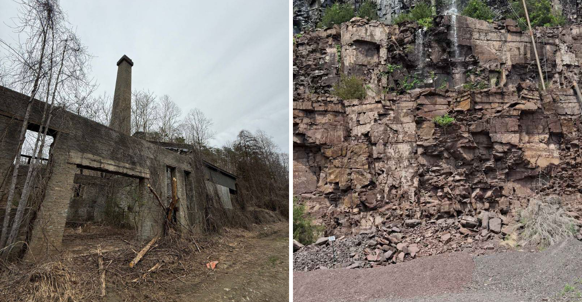
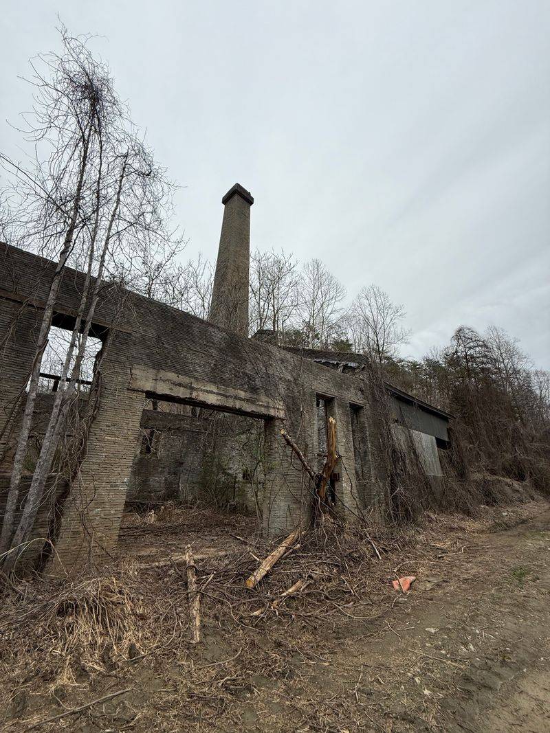
Nestled deep in the Appalachian woodlands, Gossan Lead Mine tells a story written in rust-colored stone and weathered timbers. This abandoned lead mine operated during periods when Virginia’s mineral wealth fueled regional development, leaving behind tunnels and surface structures that nature has lovingly embraced.
Moss carpets the old foundations while trees push through collapsed rooflines, creating a hauntingly beautiful fusion of human ambition and natural reclamation. The iron-stained rocks glow amber in afternoon light, especially after rain when every surface gleams with moisture.
Photographers flock here for the textural contrasts between decaying industrial materials and vibrant green foliage.
Explorers should tread carefully around the unstable structures and open shafts that remain. The surrounding forest trails offer safer vantage points for appreciating the site’s melancholic beauty.
Spring brings wildflowers that cluster around the ruins, softening the harsh lines of forgotten industry with delicate petals.
Local historians occasionally lead guided walks through the area, sharing tales of miners who once labored in darkness extracting precious lead ore. These narratives add depth to what your eyes perceive, transforming rusty metal and crumbling stone into chapters of human perseverance.
The mine sits off Forest Road 162 near the George Washington National Forest boundary, accessible via hiking trails that wind through spectacular mountain scenery. Pack sturdy boots and respect posted warnings, as the site’s beauty comes with inherent risks from unstable ground and hidden openings.
Address: Forest Road 162, Rockbridge County, VA 24450
2. Schuyler Soapstone Quarry, Nelson County
Smooth walls of pale soapstone rise vertically from a flooded quarry floor, creating an amphitheater where water replaces the stage. Schuyler’s soapstone deposits attracted industrial attention for their exceptional quality, supplying material for everything from laboratory countertops to decorative carvings.
The quarry operated for generations, employing local families whose descendants still populate this mountain community.
Today, the abandoned pit holds water so clear you can see submerged equipment resting on the bottom like artifacts in a museum display. The soapstone walls display tool marks from extraction work, linear patterns that catch shadows and create visual rhythms across the vertical surfaces.
These human-made textures contrast beautifully with the organic chaos of vegetation colonizing the quarry rim.
Wildflowers find purchase in every crack and ledge, splashing color against the monochromatic stone palette. Birch trees lean precariously over the edge, their white bark echoing the soapstone’s pale tones.
The site feels cathedral-like in its quiet grandeur, especially during morning mists that soften all edges and muffle sounds.
The quarry gained unexpected fame as a filming location, its distinctive appearance attracting location scouts seeking dramatic natural settings. Visitors often recognize the site from screen appearances, adding celebrity status to its inherent visual appeal.
This recognition has increased foot traffic, making trail maintenance and safety signage more important than ever.
Nearby Schuyler celebrates its soapstone heritage with local museums and artisan workshops where craftspeople continue traditional carving techniques.
Address: Soapstone Drive, Schuyler, VA 22969
3. Buckingham Slate Quarry, Buckingham County
Layered slate formations create natural sculptures in this sprawling quarry complex where Virginia’s finest roofing material was once extracted. The stone splits along natural planes, leaving behind geometric patterns that appear almost architectural in their precision.
Abandoned derricks and cutting sheds frame views across the quarry’s multiple levels, each representing a different operational period.
Rainwater collects in the deeper pits, forming pools that range from shallow puddles to small lakes depending on seasonal precipitation. These waters reflect surrounding slate cliffs in perfect mirror images, doubling the visual impact of the already dramatic geology.
The slate’s dark gray tones absorb light differently throughout the day, shifting from charcoal to silver as the sun moves overhead.
Adventurous photographers scramble across the tilted slate plates, seeking angles that emphasize the stone’s layered structure. The material’s tendency to fracture in flat sheets creates platforms and overhangs perfect for compositional foregrounds.
Lichens paint the older exposed surfaces in chartreuse and orange, biological art decorating industrial remnants.
Local rockhounds still visit hoping to find specimen-quality slate pieces displaying exceptional color or grain patterns. The quarry’s reputation for producing premium material means even scraps hold value for collectors and craftspeople.
Small-scale salvage continues informally, with visitors pocketing fragments as geological souvenirs.
The site sprawls across considerable acreage, with multiple access points along unmarked dirt roads that challenge navigation. Bringing detailed maps or GPS coordinates prevents getting lost in the maze of abandoned workings and overgrown paths connecting different quarry sections.
Address: Slate Road, Buckingham County, VA 23921
4. Valzinco Lead and Zinc Mine, Wythe County
Southwestern Virginia’s mineral belt conceals this extensive mining complex where lead and zinc extraction created an underground labyrinth. Surface remains include towering headframes and processing buildings slowly surrendering to gravity and vegetation.
The structures lean at precarious angles, their weathered boards and rusted metal creating compelling studies in decay and impermanence.
Spoil piles of discarded rock form artificial hills colonized by hardy pioneer species that tolerate the mineral-rich soils. These mounds offer elevated viewpoints across the entire complex, revealing the operation’s impressive scale.
From these vantage points, you can trace the logic of industrial processes from extraction through processing to transportation.
The mine’s remote location in rolling farmland means limited human disturbance since closure, allowing nature’s reclamation to proceed dramatically. Saplings push through building floors while vines engulf entire walls, creating living tapestries that change with seasons.
Winter strips away the green disguise, exposing structural bones that summer’s growth conceals.
Mineral staining creates abstract patterns on exposed surfaces, streaks of rust orange, sulfur yellow, and oxidized green painting the rocks and timbers. These chemical signatures tell stories about the ore bodies that drew miners deep underground.
Geologists visit to study the exposed strata and mineralization patterns still visible in the tailings.
Cautious exploration reveals period machinery slowly returning to earth, mechanisms frozen mid-task and overtaken by natural processes. Each rusted gear and collapsed conveyor represents technological solutions to extraction challenges, now rendered obsolete and oddly beautiful in abandonment.
Address: Valzinco Road, Wythe County, VA 24382
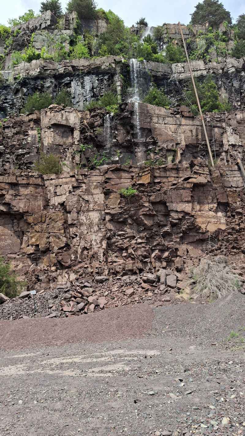
5. Fauquier White Sulphur Springs Quarry, Fauquier County
Limestone extraction shaped this northern Virginia landscape, creating vertical walls that now host surprising botanical gardens in their cracks and ledges. The quarry’s proximity to sulphur springs influenced both its geology and subsequent abandonment, as water management challenges eventually overwhelmed operational profitability.
Today, those same water issues create the site’s most photogenic feature, a series of cascading seeps that stain the white limestone in rust and green.
The mineral-laden water supports unique plant communities adapted to the alkaline conditions, species rarely found elsewhere in the region. Botanists document these specialized populations while photographers capture the delicate ferns and mosses thriving in the perpetually damp microclimate.
The combination of white stone, rust staining, and vivid green vegetation creates color contrasts that need no enhancement.
Abandoned rail lines once used to transport limestone blocks now serve as hiking paths through the quarry complex. The old railbed provides level walking and clear sight lines across the workings, making it ideal for visitors less comfortable with scrambling over rough terrain.
Interpretive signs along this route explain quarrying techniques and the geology that made this location valuable.
Spring brings wildflower displays that rival any formal garden, with columbines and wild geraniums finding homes in limestone pockets filled with accumulated soil. These seasonal bursts of color transform the stark quarry walls into living canvases.
Butterflies congregate around the seeps, adding motion and additional color to an already vibrant scene.
The site’s relative accessibility near population centers makes it popular despite limited formal amenities or oversight.
Address: Springs Road, Fauquier County, VA 20186
6. Cabin Branch Pyrite Mine, Louisa County
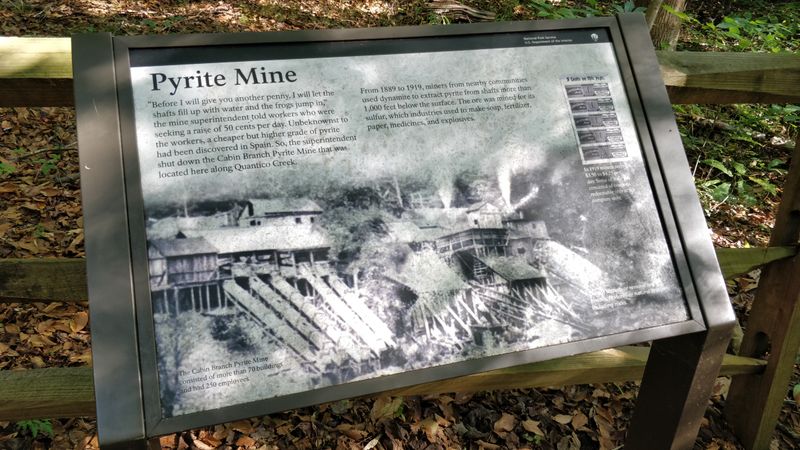
Fool’s gold glitters in the tailings piles surrounding this abandoned pyrite mine where sulfur extraction once drove industrial activity. The mineral’s presence creates otherworldly landscapes of yellow-stained earth and acidic pools that support almost no life.
This harsh beauty attracts photographers seeking alien-looking terrestrial environments, places that resemble distant planets more than Virginia countryside.
Crystalline pyrite specimens still emerge from the spoil heaps, catching sunlight in metallic flashes that explain why prospectors mistook it for precious metal. Rockhounds carefully search the tailings for well-formed crystals, geological treasures that make excellent additions to mineral collections.
The site functions as an outdoor classroom where amateur geologists learn to identify sulfide minerals and understand their formation.
Weathered mine buildings stand isolated in this barren landscape, their red brick and rusted metal contrasting sharply with the yellow earth. The structures appear almost deliberately placed for maximum visual impact, though industrial logic rather than aesthetics determined their locations.
These buildings frame photographs beautifully, providing human-scale reference points in the desolate setting.
Environmental remediation efforts have targeted the site periodically, attempting to mitigate acid mine drainage affecting downstream water quality. These interventions add layers to the site’s story, illustrating ongoing consequences of historical resource extraction.
Monitoring stations and treatment systems become part of the visual landscape, modern additions to the industrial archaeology.
Visiting requires awareness of environmental hazards including acidic water and unstable ground conditions. The site’s dramatic appearance comes with real dangers that demand respect and caution from anyone venturing onto the property.
Address: Cabin Branch Road, Louisa County, VA 23093
7. Thelma Granite Quarry, Culpeper County
Massive granite walls rise from deep water in this flooded quarry where dimensional stone was cut for monuments and buildings across the eastern seaboard. The sheer scale impresses immediately, with vertical faces extending both far above and deep below the waterline.
Divers explore the submerged portions while surface visitors marvel at the quarry’s cathedral-like proportions and the engineering required to extract such enormous blocks.
The granite’s pink and gray tones create subtle color variations across the walls, patterns determined by the stone’s mineral composition and crystallization history. Geologists read these variations like text, understanding the plutonic processes that formed this igneous intrusion millions of years ago.
For non-specialists, the colors simply create beautiful natural abstracts, especially where water and weathering have enhanced the contrasts.
Old derrick foundations and anchor points dot the quarry rim, hardware that once supported the cables and pulleys lifting multi-ton blocks from the pit. These remnants help visitors imagine the choreographed industrial ballet required to safely extract and transport such massive pieces.
Interpretive imagination transforms rusted bolts into windows onto vanished industries.
The flooded quarry has become an unofficial swimming hole during summer months, though authorities discourage this due to safety concerns and property ownership issues. The crystal-clear water tempts on hot days, its depths promising cool relief.
Responsible visitors admire without entering, respecting both legal boundaries and genuine hazards.
Surrounding forest has reclaimed former quarry roads and work areas, softening the industrial footprint with green growth. This gradual erasure demonstrates nature’s patient power to heal even dramatic human disturbances given sufficient time.
Address: Thelma Road, Culpeper County, VA 22701
8. Mineral City Manganese Mine, Page County
High in the Shenandoah Mountains, this remote manganese mine operated briefly during wartime demand before economic realities forced closure. The elevation creates spectacular views from the mine site across forested valleys and distant ridgelines, vistas that compensate for the challenging access.
Crumbling adits tunnel into the mountainside, dark openings framed by ferns and mountain laurel that bloom spectacularly each spring.
The manganese ore stained everything it touched deep purple-black, colors that persist on rocks and timbers decades after extraction ceased. These dark stains create dramatic contrasts against the mountain’s typical earth tones, marking the mine’s footprint across the landscape.
Photographers exploit these color differences, using them to lead the eye through compositions that blend natural and industrial elements.
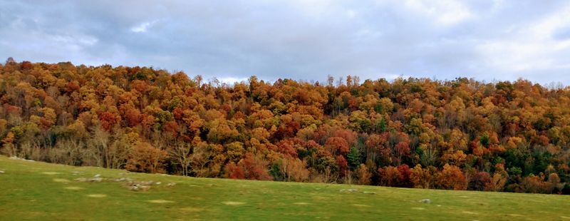
Autumn transforms the surrounding hardwood forest into a blazing tapestry of reds, oranges, and yellows that frame the mine ruins in seasonal glory. The combination of fall color, mountain vistas, and industrial remnants creates photography opportunities that attract leaf-peepers and history buffs alike.
The site becomes particularly popular during peak foliage weeks when parking along the access road becomes competitive.
Wildlife has thoroughly reclaimed the area, with black bears occasionally spotted near the old workings and wild turkeys scratching through the tailings. Deer trails crisscross the site, indifferent to property lines and historical significance.
Visitors must practice bear-aware behaviors, making noise while exploring and never approaching wildlife for photographs.
The remote location means no cell service and limited emergency access, requiring self-sufficiency and careful trip planning. Informing others of your plans becomes essential safety practice.
Address: Mineral City Road, Page County, VA 22835
Dear Reader: This page may contain affiliate links which may earn a commission if you click through and make a purchase. Our independent journalism is not influenced by any advertiser or commercial initiative unless it is clearly marked as sponsored content. As travel products change, please be sure to reconfirm all details and stay up to date with current events to ensure a safe and successful trip.