Some drives are about the destination. Getting from point A to point B as fast as possible.
These California drives are about the windows. All the way down.
The breeze doing whatever it wants with your hair. The stereo turned up.
The road curving along cliffs, through forests, across valleys that seem to go on forever. I have driven most of the famous ones, but these eleven are the ones where the weather cooperates and the views demand you slow down. You do not need a convertible.
You just need to roll those windows down and let California air do its thing. Pack snacks.
Pick a playlist. Here is where to point the car.
1. Pacific Coast Highway (Highway 1)
")
The salty air hits you before you even reach the water, and that first glimpse of the Pacific stretching out endlessly to the horizon is the kind of thing that stops your breath for a second. Highway 1 runs over 600 miles along the California coast, connecting San Diego in the south to Leggett in the north.
Few roads in the world match it for sheer visual drama.
Big Sur alone could justify an entire road trip. The cliffs drop sharply into the sea, and the iconic Bixby Bridge arches over a canyon that looks almost too perfect to be real.
Malibu brings a warmer, more relaxed energy, while the stretch near Laguna Beach fills the air with that unmistakable ocean-town feeling.
Driving this route with the windows down is practically a requirement. The breeze carries salt and pine depending on where you are, and the sound of waves below keeps you company for miles.
Pull over whenever something catches your eye, because it always will. Morning light on these cliffs is especially golden and worth setting an early alarm for.
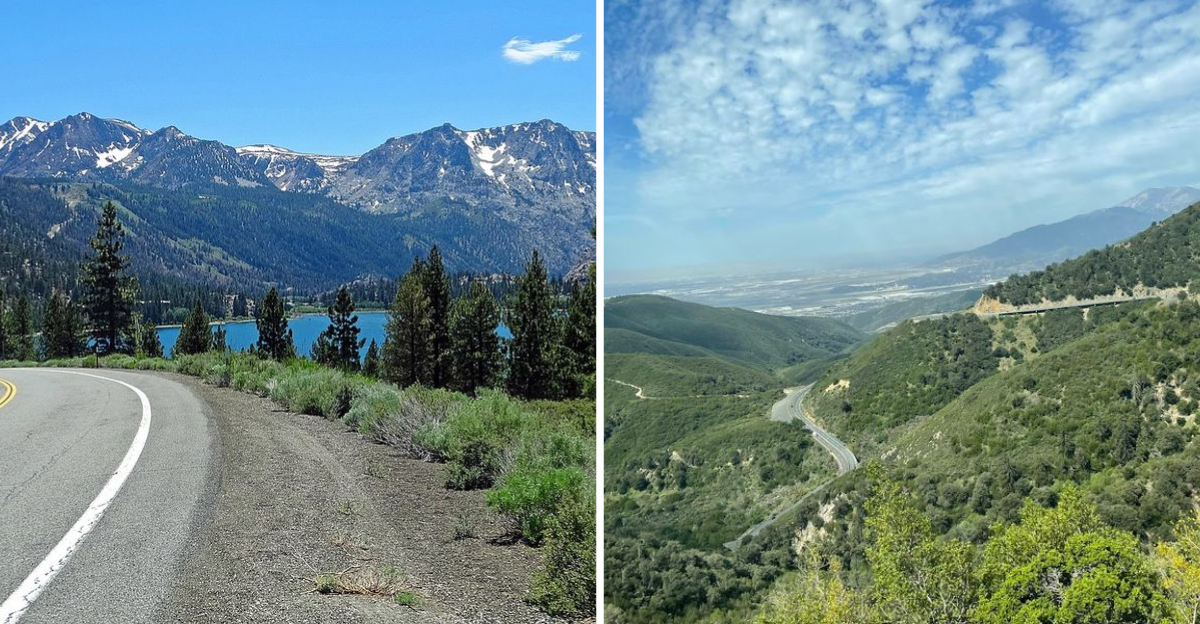
2. Highway 395 (Eastern Sierra Route)
")
Highway 395 moves through a version of California that feels completely separate from the coast, and that contrast is exactly what makes it so striking. Running from Victorville northward past Lake Topaz, this route cuts through high desert terrain with the Sierra Nevada wall rising sharply to the west.
The scale of everything out here is almost hard to process.
Mount Whitney, the tallest peak in the contiguous United States, watches over part of this drive in a way that makes the whole landscape feel ancient and enormous. Small towns like Lone Pine and Bishop have their own quiet charm, and the roadside views of Owens Valley are unlike anything else in the state.
Ghost towns dot the area and add a layer of history to every mile.
The air here is dry and clean, and on a warm afternoon with the windows down, it rushes through the car with a kind of wild freedom that coastal drives rarely offer. Fall brings brilliant color to the Eastern Sierra, making the aspens glow amber and gold along the roadsides.
This is a drive best taken slowly, with no real agenda.
3. Tioga Pass (Highway 120)
")
Crossing Tioga Pass on Highway 120 feels like driving through a postcard that nobody could have designed on purpose. The road climbs to nearly 10,000 feet, weaving through Yosemite’s high country with meadows, mirrored lakes, and jagged granite peaks as your constant company.
It only opens during summer months, which makes every trip feel a little like a limited-time invitation.
Tuolumne Meadows is one of those places that earns every bit of its reputation. The wide, open grassland surrounded by domes of polished granite has a stillness that feels earned after the winding climb to reach it.
Tenaya Lake shimmers nearby with the kind of clarity that makes you want to stop the car and just sit for a while.
The air at this elevation has a sharpness to it, cool even on the warmest summer days, and with the windows down it carries the scent of pine and granite dust. The drive connects Highway 395 on the east side to Yosemite Valley on the west, making it a perfect link between two very different California landscapes.
Plan for stops because the scenery demands them.
4. Sonora Pass

Sonora Pass is not a drive for the faint of heart, and honestly that is a big part of what makes it so memorable. At over 9,600 feet, it is one of the highest paved roads in California, and the switchbacks near the summit are steep enough to make passengers grip the door handle.
The views from the top reward every anxious curve.
The landscape here has a raw, volcanic character that sets it apart from the smoother granite scenery of nearby Yosemite. Exposed rock formations in shades of rust and gray line the road, and the ridgelines look almost otherworldly on a clear day.
Wildflowers push through the rocky soil in summer, adding unexpected bursts of color to the rugged scene.
Coming down the eastern side, the road drops dramatically and the valley below opens up in a way that feels almost theatrical. The wind at the summit has real force to it, and with the windows down on the descent, the cold air rushes in with a kind of exhilarating intensity.
Highway 108 carries you over the pass, and the whole experience takes only a couple of hours but stays with you much longer.
5. Ebbetts Pass National Scenic Byway

Ebbetts Pass has a reputation among road-trip enthusiasts as one of the most underrated drives in the entire Sierra Nevada range, and after taking it once it becomes very easy to understand why. Highway 4 carries you over the pass at around 8,730 feet, threading through terrain that shifts constantly between dense forest, open meadow, and dramatic volcanic rock.
The road is narrow in places, which adds to the sense of adventure.
The ancient volcanic formations along this route give the scenery a prehistoric quality that feels genuinely different from other Sierra passes. Big Trees State Park sits near the western approach, where giant sequoias create cathedral-like shade over the road.
That transition from towering redwoods to exposed alpine ridgeline happens faster than you would expect.
The byway is seasonal, closing in winter and reopening when snowpack allows, so arriving in late spring sometimes means passing through remnant snowfields even on a warm day. The air carries that cool, high-altitude freshness that hits best when the windows are fully down and the road ahead curves out of sight into the trees.
Few drivers tackle this one, which means you often have the whole winding stretch nearly to yourself.
6. Carson Pass Highway (Route 88)
")
Route 88 over Carson Pass carries a quiet historical weight along with some genuinely spectacular mountain scenery. John C.
Fremont crossed this pass back in 1844, and the landscape looks wild enough today that the history does not feel entirely distant. The road reaches about 8,574 feet at the summit, offering views across the Sierra crest that stretch far in every direction.
Caples Lake and Silver Lake appear along the western descent, their blue surfaces framed by pine-covered slopes and rocky ridges. These lakes are calm and reflective on still mornings, and pulling over to watch the light shift across the water is one of those small pleasures that makes a long drive feel worthwhile.
The surrounding terrain has that layered volcanic geology that shows up in deep reds and purples in the exposed rock faces.
This route connects the Sacramento Valley to the Great Basin, and the shift in landscape and air quality as you cross the pass is noticeable. On the eastern descent, the air turns drier and the vegetation thins out into high desert scrub.
With the windows down, you can actually feel that atmospheric change happen in real time, which is one of the more quietly remarkable sensory experiences any California drive offers.
7. Angeles Crest Scenic Byway

Most people driving through Los Angeles have no idea that just a short climb north of the city puts you in a completely different world. Angeles Crest Scenic Byway, running along Route 2 through the San Gabriel Mountains, transforms the urban sprawl below into a distant haze while pine trees and canyon walls take over on all sides.
The contrast happens fast and it always feels a little surreal.
Mount Wilson Observatory sits along a spur off this road, and on a clear day the views back toward the LA basin are staggering. The road itself winds through the Angeles National Forest with stretches of shaded canopy giving way to exposed ridgeline where the wind picks up considerably.
Wrightwood and Big Pines sit at the eastern end of the byway, offering small-town stops with mountain charm.
Summer afternoons bring a welcome coolness to this drive that the city below rarely offers, and the air smells of pine resin and dry earth in a way that feels genuinely restorative. Winter occasionally dusts the higher elevations with snow, making the road even more visually dramatic.
This is the kind of drive that reminds Angelenos their city sits right at the edge of something wild and vast.
8. Palms to Pines Scenic Byway

The Palms to Pines Scenic Byway earns its name in the most literal and satisfying way possible. Starting near Palm Springs in the low desert, the road climbs rapidly through the Santa Rosa Mountains, and within about an hour the palm trees and sand give way to towering pines and cool mountain air.
That kind of ecological transformation packed into such a short distance is genuinely rare.
Highway 74 handles most of the climb, and the switchbacks on the ascent offer increasingly dramatic views back down toward the Coachella Valley. On a clear day, the valley floor stretches out below like a map, with the Salton Sea glinting in the distance.
The shift in temperature between the desert floor and the mountain crest can be dramatic, sometimes exceeding 30 degrees.
Idyllwild sits near the top of this drive and has a small-town mountain feel that makes it a great excuse to stop, stretch, and wander a bit. The air up there has a freshness that feels almost therapeutic after the dry desert heat below.
With the windows down on the ascent, you can actually feel the air cooling and changing around you, which turns the whole drive into something more like an experience than just a commute.
9. Rim of the World Highway

The name alone sets expectations high, and somehow the Rim of the World Highway still manages to exceed them. Running along Highway 18 through the San Bernardino Mountains, this route clings to the edge of a ridge with the entire Inland Empire spread out below and, on exceptionally clear days, a faint shimmer of the Pacific visible in the distance.
It is the kind of view that makes you pull over without really deciding to.
The drive threads through Crestline, Lake Arrowhead, and Big Bear, each community with its own character and pace. Lake Arrowhead feels like a mountain resort town with a slightly old-fashioned charm, while Big Bear has a more outdoorsy, active energy depending on the season.
The road between them winds along the ridgeline with frequent pullouts that beg for a pause.
A detour up to Keller Peak Fire Lookout rewards the effort with a 360-degree view of mountains, lakes, and valleys that is hard to match anywhere in Southern California. The air along this entire route has a crispness that the valley below rarely experiences, and with the windows down on a summer afternoon, the breeze carries the scent of pine and mountain earth in a way that feels genuinely refreshing.
10. Sunrise Highway (S1) in Mount Laguna
 in Mount Laguna")
Sunrise Highway might be one of the best-kept secrets in Southern California, tucked into the Laguna Mountains east of San Diego with a personality that feels completely its own. County Road S1 climbs through the Cleveland National Forest and reaches elevations above 6,000 feet, where the air cools noticeably and the pine trees grow thick on both sides of the road.
The quiet up here is the kind that feels earned.
The views from various pullouts along this route look east toward the Anza-Borrego Desert State Park, with the land dropping away sharply into a vast expanse of sand and rock. That visual contrast between lush forest and open desert is one of the more striking things about this drive.
Early mornings bring a soft light that makes the whole landscape glow in shades of amber and rose.
Laguna Meadow is worth a stop on the way through, a wide open grassland that sits peacefully among the pines and feels almost alpine in character. The road itself is not heavily trafficked, which means long stretches where it feels like you have the whole mountain to yourself.
With the windows down and the forest air rushing in, this drive has a meditative quality that is hard to replicate anywhere else in the region.
11. June Lake Loop

The June Lake Loop is one of those short detours that punches way above its weight in terms of scenery. Just off Highway 395 in the Eastern Sierra, this roughly 17-mile loop circles through a cluster of glacially carved lakes set against some of the most dramatic mountain backdrops in California.
It takes maybe an hour to drive without stopping, but most people end up spending much longer.
June Lake, Silver Lake, Grant Lake, and Gull Lake each have their own mood and color, ranging from deep blue-green to a lighter turquoise depending on the light and time of year. The loop is especially famous in autumn when the aspens turn a blazing yellow-gold that reflects off the water in a way that borders on unrealistic.
I have seen photos of this place that looked edited, but in person the color is even more saturated.
The village of June Lake sits along the loop with a low-key mountain energy and just enough amenities to make a short stop feel worthwhile. The road itself is smooth and easy, making it accessible even for those less comfortable with mountain driving.
With the windows down and the Sierra air pouring in, this loop is the kind of small discovery that makes a long road trip feel complete.
Dear Reader: This page may contain affiliate links which may earn a commission if you click through and make a purchase. Our independent journalism is not influenced by any advertiser or commercial initiative unless it is clearly marked as sponsored content. As travel products change, please be sure to reconfirm all details and stay up to date with current events to ensure a safe and successful trip.