Everyone heads to the famous spots in Colorado. Garden of the Gods.
Red Rocks. The usual postcard views.
But there is a forgotten corner of the state where the rocks look like they fell from another planet. Weird spires.
Balanced boulders. Formations that twist upward like frozen flames.
I had never heard of this place until a local mentioned it quietly, almost like he was giving away a secret. The drive is rough.
The trail is not marked. And most people never bother to find it.
Which is exactly why it still feels untouched. I wandered through those shapes for hours, completely alone, feeling like I had stumbled onto a movie set. Colorado’s hidden wonders are still out there if you know where to look.
The History Behind Colorado’s First National Monument
Before it became a footnote in Colorado’s history, Wheeler Geologic Area was actually the state’s very first national monument. President Theodore Roosevelt designated it in 1908, recognizing just how bizarre and spectacular the landscape truly was.
But the monument had a problem that no amount of presidential prestige could fix: it was brutally hard to reach. Visitor numbers stayed low for decades.
By 1950, President Harry Truman quietly revoked its monument status, and it was folded into the Rio Grande National Forest as a geologic area instead.
That demotion is part of what makes this place so fascinating to me. A spot remarkable enough to earn national monument status got essentially forgotten because the road in was too rough.
Full wilderness protection came back in 1993 under the La Garita Wilderness designation, which at least means the land is safe from development. The history adds a layer of melancholy that pairs perfectly with the strange, haunted beauty of the formations themselves.
Knowing this place was once celebrated and then quietly set aside makes every visit feel a little like rediscovering something the world lost.
The Volcanic Origins That Created Something Truly Extraordinary
About 25 to 28 million years ago, the La Garita Caldera erupted in what geologists consider one of the largest volcanic events in Earth’s entire history. That single eruption buried the surrounding landscape under roughly 1,200 cubic miles of ash and volcanic debris, in some places stacking more than 300 feet deep.
Over millions of years, wind and water slowly carved that compacted ash, called tuff, into the shapes we see today. The result is a landscape of hoodoos, spires, and hollow domes that feel almost sculpted by hand.
Additional eruptions from the Cochetopa and San Luis Volcanoes added more layers to the geological story, giving the formations a richly textured, almost striated appearance up close. What looks alien is actually ancient, the slow result of forces so massive they are nearly impossible to picture.
I find it genuinely humbling to stand in a place where the ground beneath your feet is the remnant of a catastrophe that dwarfs anything in recorded human history. The geology here is not just a backdrop; it is the whole story.
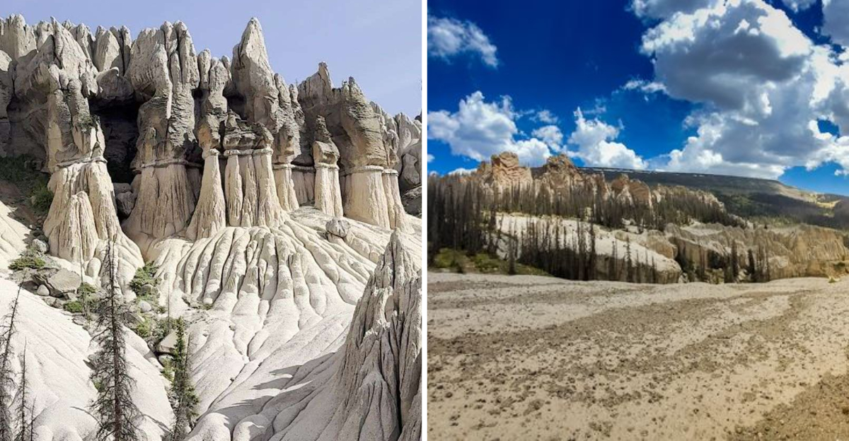
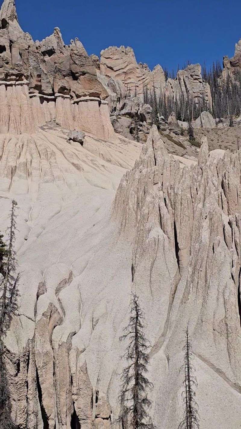
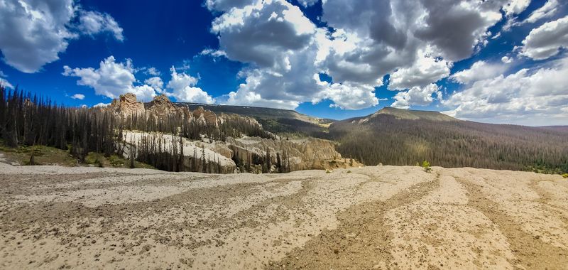
What the Formations Actually Look Like Up Close
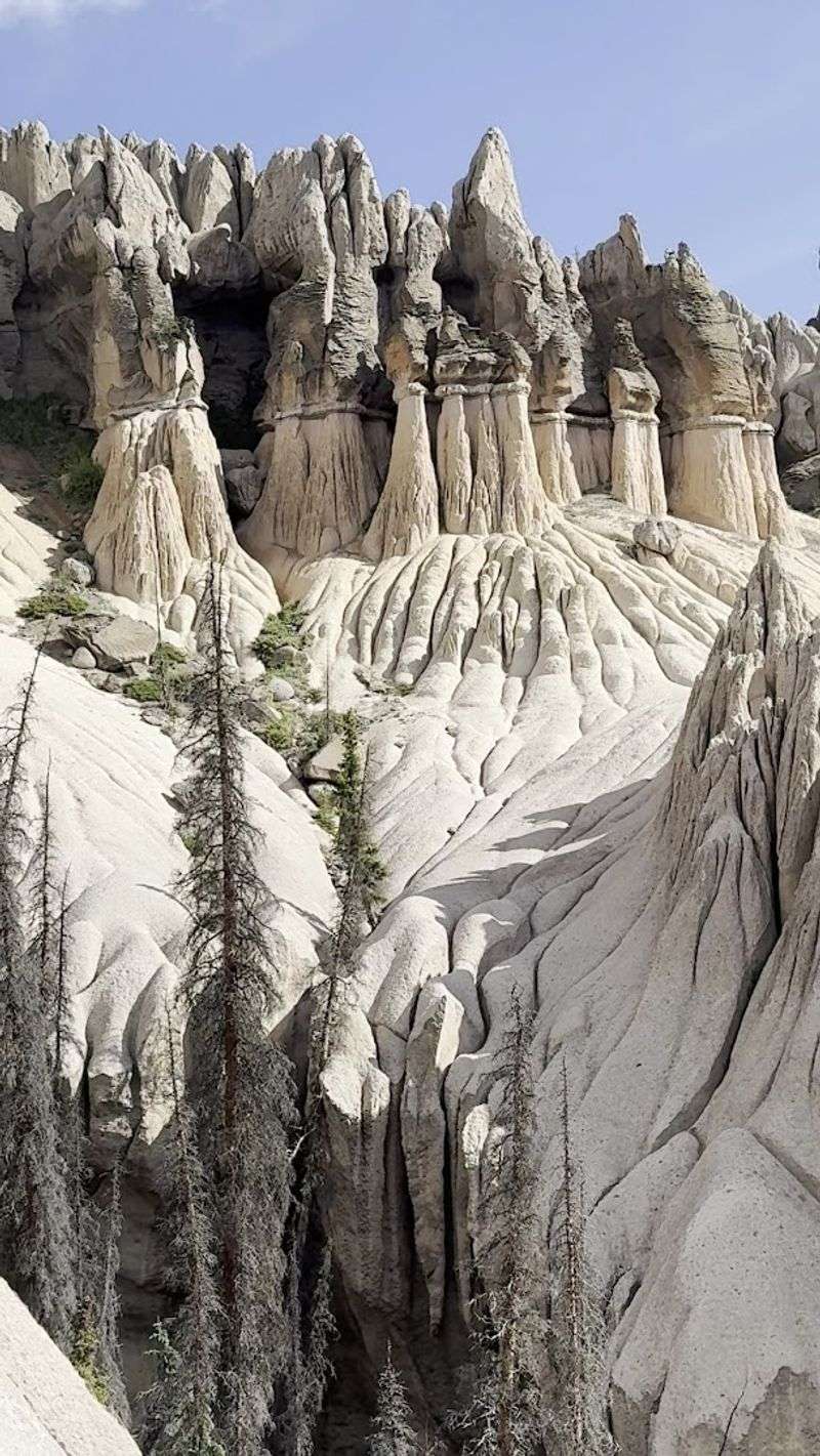
Nothing quite prepares you for the moment the trees thin out and the formations come into full view. The rocks are pale, almost white in bright sunlight, which makes them glow against the deep blue Colorado sky in a way that feels completely unreal.
Some of the spires are narrow and blade-like, while others swell into rounded domes before tapering to a point. A cluster of eroded figures near the center of the area has earned the nickname “Dante’s Lost Souls,” and once you see them, you understand why.
They look like figures frozen mid-motion, hunched and reaching, carved by wind into something that feels intentional.
The overall impression is of a ghost city, quiet, crumbling, and strange. Shadows shift constantly across the surface as clouds move overhead, and the formations seem to change shape depending on where you stand.
Up close, you can see the texture of the tuff itself, grainy and rough, pocked with holes where softer material eroded away first. It is the kind of place where you keep stopping to look back because every angle offers something new and slightly unsettling in the best possible way.
The Two Ways to Reach This Remote Wilderness
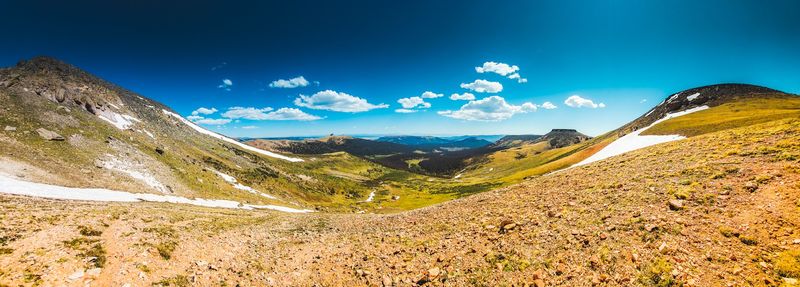
Reaching Wheeler Geologic Area is not a casual afternoon decision. There are two main options, and neither one is what you would call convenient.
The first is a strenuous 16 to 17 mile roundtrip hike along the East Bellows Trail, designated Forest Service Trail 790, starting from the Hansen Mill trailhead.
The hike climbs through dense forest and open meadows before delivering you to the formations. It is long, it is physically demanding, and it is absolutely worth it for those who enjoy a serious day on the trail.
Plan for a full day or consider camping overnight to make the most of the experience.
The second option is Forest Road 600, also called Pool Table Road, a 14-mile four-wheel-drive route that requires a high-clearance 4×4 vehicle or ATV. Deep ruts, narrow switchbacks, and steep grades make this road genuinely challenging, not just adventurous-sounding.
Avoid it entirely during wet weather or monsoon season, as the road becomes dangerous quickly. Either way you choose to arrive, the remoteness is part of what makes Wheeler feel so special.
The effort filters out the casual crowd and leaves behind only those who really mean it.
Planning Your Visit: What to Know Before You Go
Wheeler Geologic Area rewards those who plan carefully and punishes those who do not. There is no cell service out there, full stop.
Download your maps, save your GPS coordinates offline, and tell someone your plans before you leave.
The only restroom facility along the route is located at Hansen Mill, the common starting point for the hike. Once you leave that trailhead, you are on your own in genuine wilderness.
Pack out everything you bring in, because the La Garita Wilderness has strict leave-no-trace standards.
Camping overnight near the formations is allowed and honestly makes the whole experience richer. Watching the light change on those pale spires at dusk is something I would not trade for a comfortable hotel room.
Bring more water than you think you need, because the elevation and dry mountain air will dehydrate you faster than expected. The area sits at roughly 12,000 feet, so altitude is a real consideration, especially if you are coming from a lower elevation.
Start your trip early in the morning to avoid afternoon thunderstorms, which are common during summer months and can move in fast. Preparation here is not optional; it is the difference between a great trip and a miserable one.
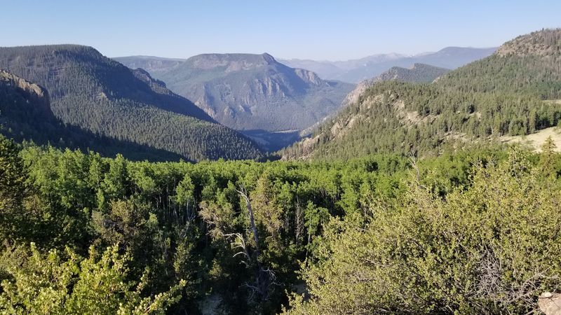
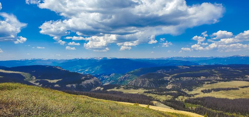
The Wildlife and Landscape Surrounding the Formations
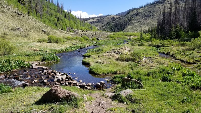
The journey to Wheeler is not just about the destination. The surrounding La Garita Wilderness is dense with life, and paying attention to what is happening around you on the trail adds a whole other dimension to the trip.
Elk are common in this part of the San Juans, and you have a reasonable chance of spotting them, especially in the early morning or at dusk. Mule deer move quietly through the forest understory, and if you are patient and lucky, you might catch a glimpse of a black bear at a distance.
Birds are abundant too, with Clark’s nutcrackers and Steller’s jays making plenty of noise along the trail.
The meadows between the tree line and the formations burst with wildflowers during summer, particularly in July and early August. Columbine, paintbrush, and lupine create patches of vivid color against the grey-green of the alpine grass.
The contrast between that soft, living landscape and the stark, pale rock formations at the end of the trail is genuinely striking. The wilderness surrounding Wheeler is not just a backdrop to push through; it is its own reward, layered and alive in ways that slow you down in the best way.
Why Wheeler Geologic Area Deserves a Spot on Your Colorado Bucket List
Colorado has no shortage of stunning places to visit, but Wheeler Geologic Area occupies a category almost entirely its own. It is not just scenic; it is genuinely surreal in a way that is hard to communicate until you are standing in the middle of it.
The combination of deep geological history, difficult access, and sheer visual strangeness makes it one of those rare destinations that actually lives up to the buildup. Most people who make the effort come back talking about it for years.
There is also something meaningful about visiting a place that was once celebrated, then forgotten, and is now quietly waiting to be rediscovered. Wheeler does not ask for much from its visitors beyond effort and respect.
It sits out there in the San Juans, doing what it has been doing for millions of years, completely indifferent to whether anyone shows up or not. That indifference is part of its appeal.
If you are the kind of traveler who wants something real, something earned, and something genuinely unlike anything else in the American West, Wheeler Geologic Area belongs on your list. Address: Forest Road 600, Creede, Colorado 81130.
Dear Reader: This page may contain affiliate links which may earn a commission if you click through and make a purchase. Our independent journalism is not influenced by any advertiser or commercial initiative unless it is clearly marked as sponsored content. As travel products change, please be sure to reconfirm all details and stay up to date with current events to ensure a safe and successful trip.