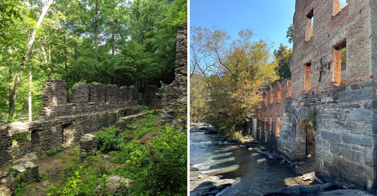
That quiet settles over a place where machines used to roar, and Georgia has more of those spots than most people realize. I keep coming back to them, tracing creek banks and forest trails until a wall of hand-cut stone appears out of nowhere, a secret someone forgot to keep.
Some of these sites powered the state’s earliest textile boom, others sprang up around gold, paper, or silk, and nearly all of them were undone by fire, flood, war, or a railroad that simply chose a different route.
The stone walls are often still standing, held together by mortar that has outlasted the industry they once supported.
What is left behind feels honest in a way polished museums rarely do, with trees growing straight through old foundations and water still tumbling over dams that no longer power anything.
The route runs from the woods west of the city out to the river, with stops in the north Georgia foothills along the way.
Pack decent shoes and a little patience, because the best parts of these places take a short walk to reach.
1. New Manchester Mill Ruins, Sweetwater Creek State Park, Lithia Springs
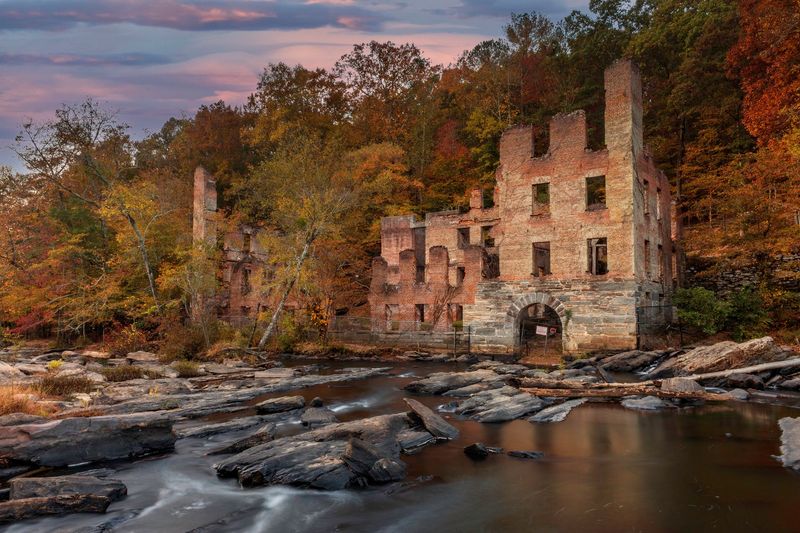
Five stories of stacked stone rising out of a hardwood forest is not what most people expect twenty minutes from downtown Atlanta. Yet there it is, empty window openings framing sky and green leaves.
The New Manchester Manufacturing Company was reorganized from the earlier Sweetwater Manufacturing Company in 1857, and for a short while it hummed as a serious piece of the regional economy. Union troops burned it in 1864, and the shell has been softening into the landscape ever since.
I usually take the Red Trail down, though the Blue Trail is the one I recommend to friends who like a little challenge. It narrows across rocky outcrops above white-water rapids, with a chain railing bolted into the stone to steady you through the tightest stretch.
Wooden steps climb a boulder near the overlook, and the angle from up there is the one worth lingering over.
Ferns, magnolias, wild azaleas, and tall hardwoods crowd in on every side, and the whole scene feels peaceful in a way that sits oddly against its history. Go on a weekday morning if you can, when the water noise is the loudest thing around.
Address: 1750 Mount Vernon Road, Lithia Springs, GA 30122
2. Roswell Mill Ruins, Old Mill Park, Roswell
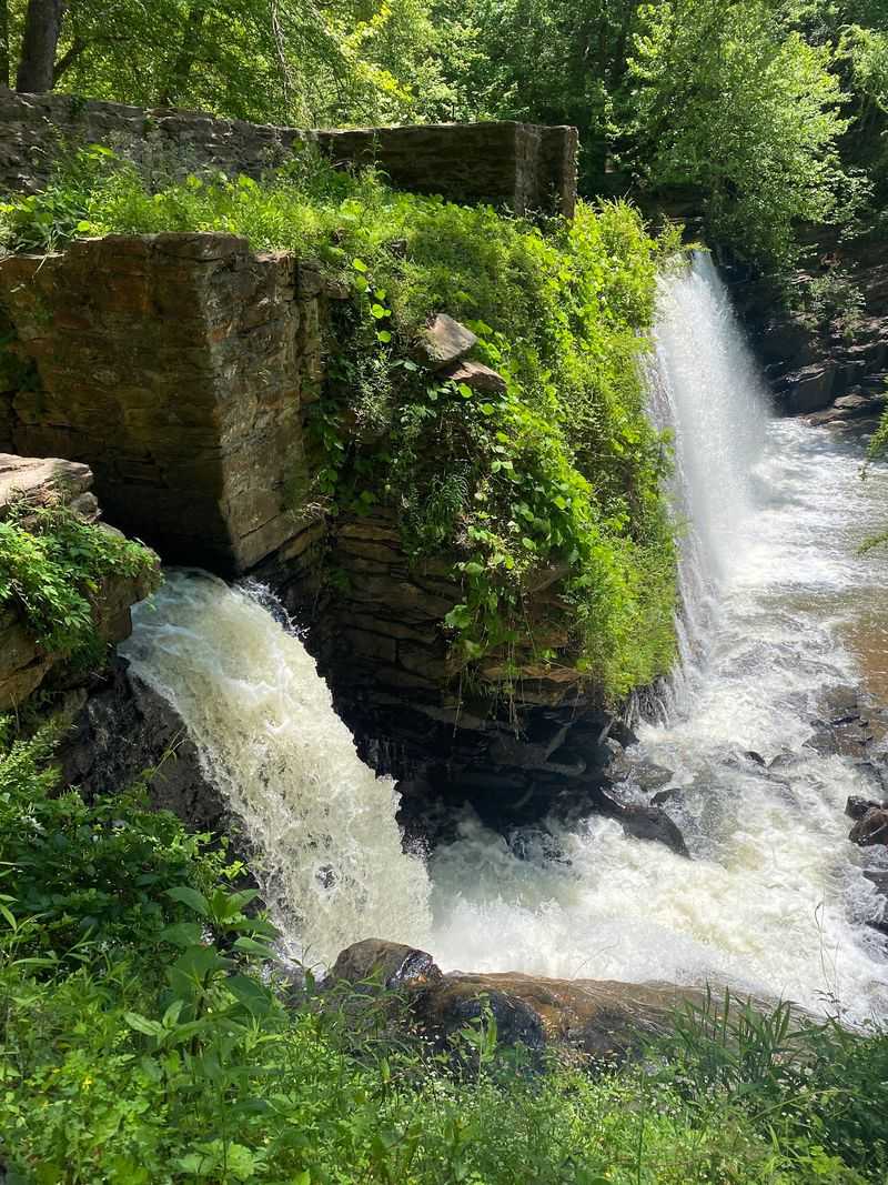
Water falling roughly thirty feet over an old dam has a way of drowning out traffic, phones, and pretty much everything else. That waterfall is why Old Mill Park stays busy with photographers on almost any clear weekend.
The stone remains along Vickery Creek belonged to the Roswell Manufacturing Mills, first built in 1839 with a second mill following in 1853. Cotton and woolen goods came out of them until Union forces destroyed the operation in 1864.
One mill was rebuilt after the war, then lost to fire in 1926, which is why the walls look the way they do now.
My favorite approach is across the covered pedestrian bridge, where the view opens up over the water and the trail system spreads out on the far side.
Those paths connect into the Vickery Creek network within the Chattahoochee River National Recreation Area, moderate in difficulty with wooden steps climbing through the trees in places. Water access near the falls is restricted for safety and preservation, so plan on viewing from the designated overlooks.
Honestly, the elevated angle is better anyway.
Address: 95 Mill View Ave, Roswell, GA 30075
3. Scull Shoals Historic Site, Greensboro
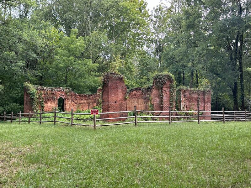
Deep inside the Oconee National Forest sits a town that the earth quietly buried. Not metaphorically either.
By 1860 the rapids that gave the settlement its name lay under fourteen feet of silt.
European settlers established the place in 1784 along the Oconee River, and it grew into a genuine industrial village. Georgia’s first paper mill started here in 1811, joined by a sawmill, a grist mill, and a cotton gin, with a post office running from 1825 to 1861.
Sedimentation from heavy cotton farming upstream, plus fires and floods, wore the community down until it faded around the Civil War era.
What survives rewards slow walking. A four-story brick warehouse from 1846 still stands in pieces, along with parts of an old store and, if you look toward the water, a granite support beam from an 1809 toll bridge that a flood took out in 1887.
Prehistoric earthworks known as the Scull Shoals Mounds add a much older layer to the ground beneath your feet.
Paths get overgrown, so bring bug spray and imagination. There are picnic spots here, and they are among the most peaceful I have found anywhere in the state.
4. Sope Creek Paper Mill Ruins, Marietta
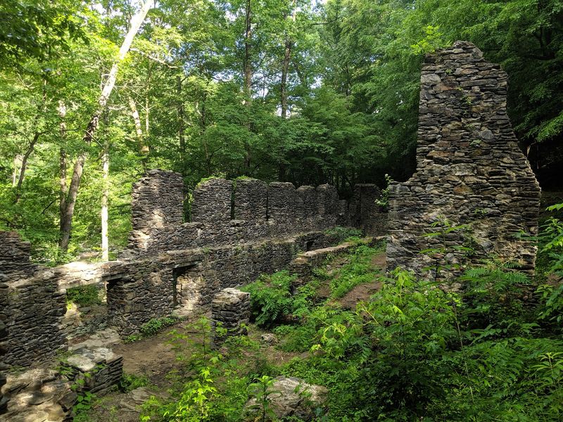
One wall at Sope Creek stands tall enough and jagged enough that people genuinely call it castle-like, and the description sticks once you see it. Oak and hickory press right up against the stonework.
Production started here in 1855 under the Marietta Paper Mills, and by 1864 it ranked as the state’s first paper mill. Output included newsprint and cartridge paper for guns, with longstanding rumors that Confederate money was printed from its stock.
Union troops destroyed it during the Battle of Atlanta in 1864. Rebuilt and running again by 1868, it burned partially in an accidental fire in 1870, was rebuilt once more, then finally closed for good by 1902 after money troubles.
The hike in is friendly to almost anyone, roughly a mile and a half round trip along the Sope Creek Trail toward the ruins and Sibley Pond.
Angular boulders line the water, seasonal wildflowers show up in patches, and the whole corridor belongs to the Chattahoochee River National Recreation Area.
I like it best after rain, when the creek runs loud and the stone darkens. Parking fills fast on weekends, so arrive early.
Address: Brook Hollow Cir, Marietta, GA 30067
5. Concord Woolen Mill Ruins, Smyrna
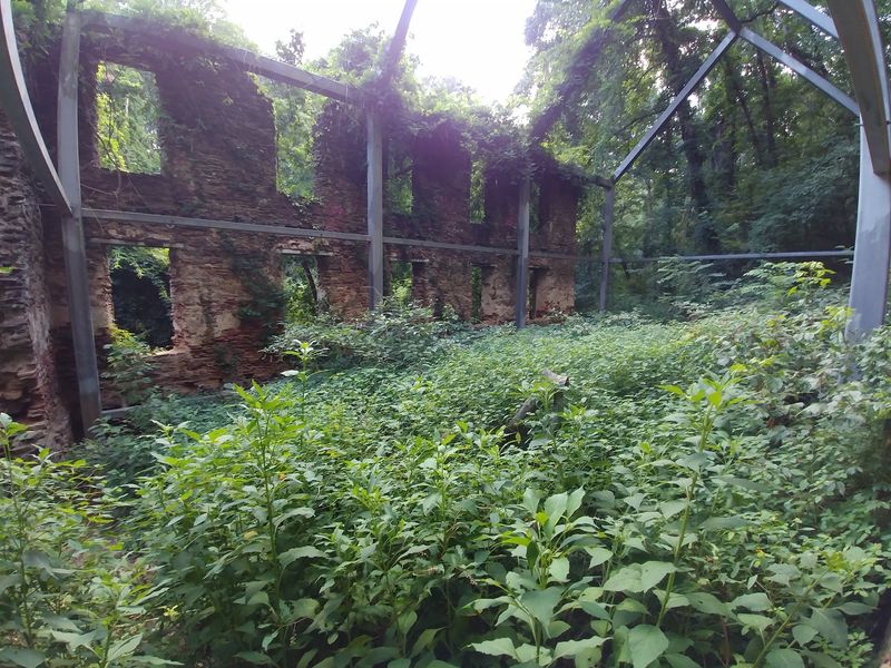
Trees growing straight up out of a building’s interior is a strange sight, and at Concord the county has decided to let it happen on purpose. Steel I-beams, sometimes called ghost framing, hold the leaning brick walls steady so nature can keep doing its thing without the whole thing collapsing.
Robert Daniell and Martin Ruff opened the mill in 1847, making it one of Cobb County’s earliest large industrial employers.
Confederate uniforms were produced here until Union troops under General William T. Sherman destroyed it on July 4, 1864.
It reopened by 1868, burned again in 1889, got rebuilt one more time, and was finally abandoned by 1916 after its best years had passed.
Those brick walls measure about two feet thick, which explains why so much of them survived a century of neglect.
Reaching the site is easy. The Heritage Park Trail runs mostly flat through light woods along Nickajack Creek, with an elevated boardwalk carrying you over wetlands that stay shaded and cool.
A presentation board near the ruins fills in the timeline, and reading it while the creek murmurs behind you makes the history land differently.
Address: Heritage Park Trail, Smyrna, GA 30082
6. Olde Rope Mill Ruins, Woodstock
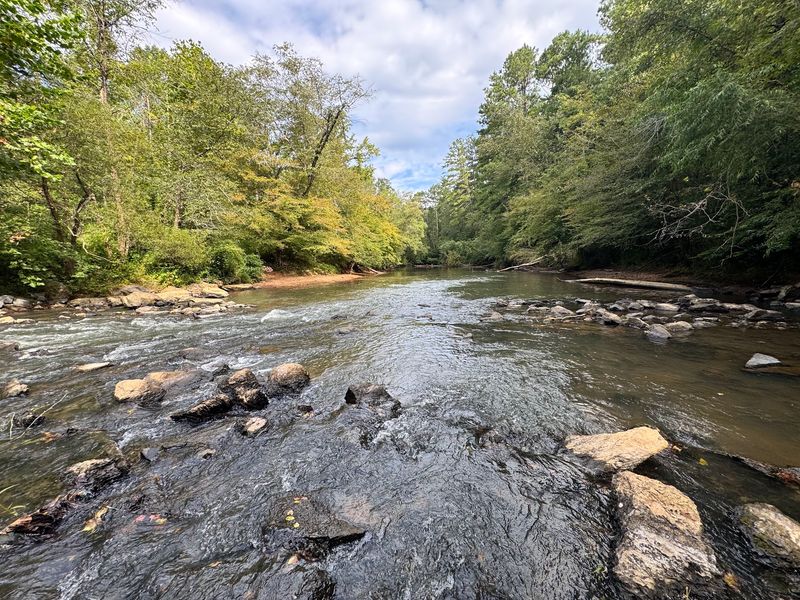
Not every ruin announces itself. The remnants at Olde Rope Mill Park are low, weathered, and easy to walk past if you are staring at the water instead of the ground, which most people are.
A cotton rope mill worked here during the 1800s, following earlier gristmills that harnessed the current of the Little River, Noonday Creek, and the Etowah.
The park now covers more than 200 acres, and it has become one of the busier outdoor spots in Cherokee County for good reason.
Mountain bikers dominate the scene, especially on the Taylor Randahl Memorial trails, which twist through the woods with a few genuinely pretty overlooks. Hikers share plenty of the same ground without much friction.
Down at the river, people fish, launch kayaks and canoes, and paddleboard when the water cooperates.
Picnic areas and small decks sit above the current, and I have spent a lazy hour on one of them doing absolutely nothing productive.
Historical markers scattered around the park explain what once stood here, which turns a casual afternoon into something with a bit more weight behind it.
Address: 690 Olde Rope Mill Rd, Woodstock, GA 30188
7. High Falls Mill Ruins, High Falls State Park, Jackson
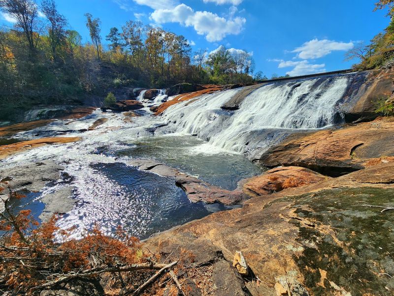
A railroad decision ended this town. That is the short version, and it is a reminder of how fragile prosperity could be in 19th-century Georgia.
A busy industrial community grew up around the water power here, then the railroad routed itself elsewhere and the whole place emptied out, leaving mills and factories to weather away into the riverbank.
The falls themselves are the headline now, the largest waterfall in middle Georgia, dropping in wide sheets into the Towaliga River. Standing water noise fills the entire park.
Beyond the cascade, a 650-acre lake spreads out for anglers and boaters, and the shoreline stays surprisingly quiet once you get away from the main overlook.
Close to five miles of trails thread through hilly forest and along the river, and they pass old foundation stones that are easy to miss unless you slow down and look for straight lines among the rocks.
What I appreciate here is the contrast. Raw natural power on one side, the modest leftovers of human ambition on the other, both sharing the same stretch of river without any drama.
Address: 76 High Falls Park Dr, Jackson, GA 30233
8. Sweetwater Factory Town Site, Lithia Springs
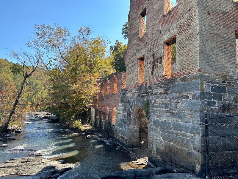
A mill is one thing. An entire company town wrapped around it is something else, and that is what once filled these woods in the years before the Civil War.
The New Manchester Manufacturing Company anchored the settlement, giving work and housing to families whose whole daily rhythm revolved around the textile operation.
Union troops recognized how valuable the place was to the Confederate supply chain and destroyed the mill in 1864, and the town around it never came back.
Walking the wooded ground today, the surviving five-story stone shell is the clearest evidence anything happened here at all. The Red Trail is the usual route in, and the walls rise out of the foliage suddenly enough to stop conversation mid-sentence.
Everything else has gone green. Ferns, magnolias, and wild azaleas crowd the slopes, and white-water rapids churn below the trail with real force after heavy rain.
I find myself thinking about the ordinary details, the footpaths and gardens and the sound of a workday shift ending, none of which left a trace.
Bring water, watch your footing near the creek, and give yourself more time than you think you need.
9. Auraria Ghost Town, Auraria
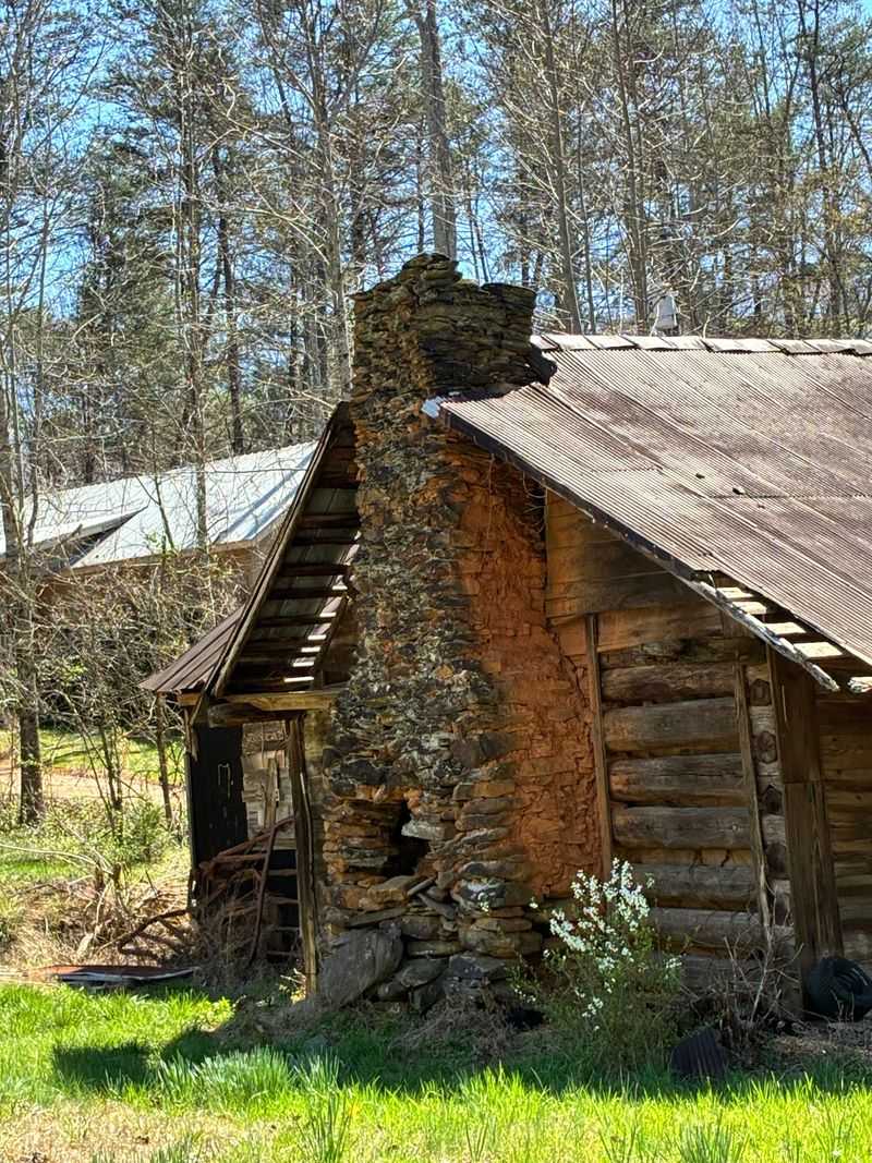
Gold turned this mountain crossroads into a boom town almost overnight, and then it emptied out just as fast. Auraria was laid out in June 1832, four years after gold was found in the area.
It went by other names first, including Nuckollsville, before being renamed that November after a Latin word meaning gold mine.
By May 1833 roughly a thousand people lived here, supported by stores, law offices, and taverns, and it briefly served as the temporary county seat of Lumpkin County.
A legal fight over a gold lot sent the county seat and the federal mint to nearby Dahlonega later that same year, and the rush westward to California and Colorado finished the job.
Southwest of Dahlonega, the leftovers are scattered along a quiet road. Woody’s Store stayed open into the 1980s and still shows a decaying Coca-Cola sign through the glass.
A red house that once served as a bank faces abandoned homes and outbuildings, including the circa-1826 Graham Hotel, a registered historical structure now in rough shape.
Some buildings sit on private land, so view from the road. The old cemetery is worth a respectful stop.
10. Ebenezer Mill / Industrial Ruins, New Ebenezer
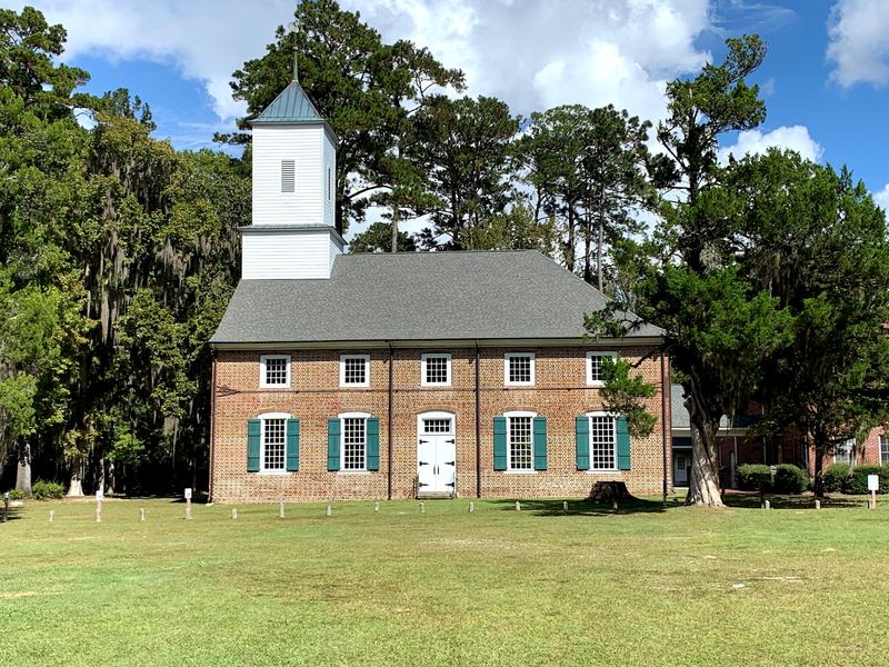
Silk, of all things, once made this corner of Effingham County prosperous. Salzburger refugees founded the original settlement in 1734 on Ebenezer Creek, then moved in 1736 to better ground nearer the Savannah River.
At the newer site they built mills, including silk mills that turned into a genuinely profitable industry and gave the community real standing in colonial Georgia.
The British invasion of 1778 during the Revolutionary War wrecked the town, and it never truly recovered, mostly disappearing by 1855. At the older site, a sawmill was lost to a flood by 1739 and the location was abandoned soon after.
Down along the creek bank today, decaying pilings from those sawmill footings and old planks under a shed are the only industrial clues left.
The Jerusalem Lutheran Church, finished in 1769, is the great survivor, Georgia’s oldest church building and home to the oldest continuously operating Lutheran congregation in the country.
A Salzburger museum in a replica orphanage and the relocated 1755 Salzburger House fill in the human side of the story.
Shady trails and slow-moving water make this the most contemplative stop on the whole route.
Address: 2887 Ebenezer Rd, Rincon, GA 31326
