Some hikes are beautiful. Others are insanely beautiful, the kind of views that make you forget the burning in your legs.
These Virginia hikes are actually worth the sweat, trails that reward every step with a view you will not forget. I have hiked each one, and each time I have stood at the summit and thought, “this was worth it.” The trails range from moderate to challenging, but the payoff is always huge.
Mountains, waterfalls, valleys, and forests, all from a perspective that only hikers get to see. Virginia has plenty of trails, but these are the ones that deliver.
Pack water, lace up your boots, and get ready to sweat.
Old Rag Mountain

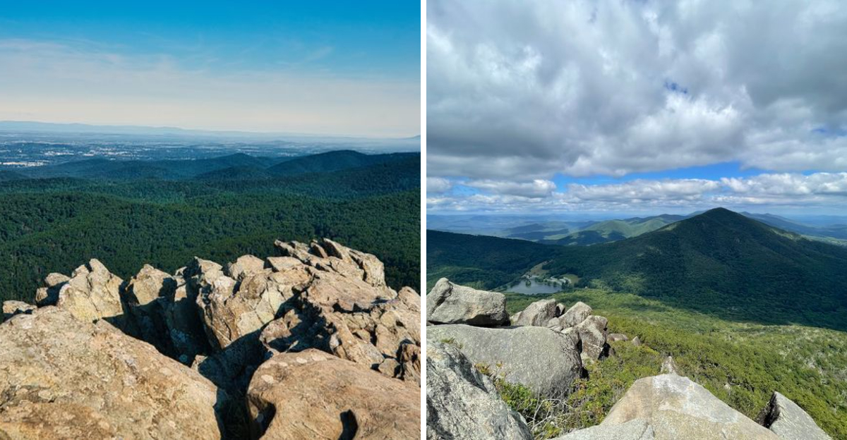
Old Rag Mountain is the kind of hike that earns bragging rights. Located inside Shenandoah National Park, this nearly ten-mile circuit is a full-body adventure involving car-sized boulders, tight crevice crawls, and rock scrambles that feel more like a jungle gym than a trail.
The elevation gain sits around 2,600 feet, so your legs will absolutely know they worked.
What makes this mountain legendary is the rock scramble near the summit. You are not just walking uphill here.
You are squeezing through gaps, hauling yourself up granite faces, and figuring out where your hands go before your feet follow. It is physical, it is mental, and it is genuinely thrilling.
Standing at the top rewards every moment of effort. The summit delivers stunning 360-degree panoramic views across the Luray and Shenandoah Valleys, with rolling blue ridges stretching as far as the eye can see.
Old Rag is actually a monadnock, meaning it stands as an isolated rock formation visible from parts of Skyline Drive.
Because of its massive popularity, a ticket system is now required, so planning ahead is essential. Going early in the morning or during the off-season dramatically improves the experience.
This is not a beginner trail, but for anyone ready to commit to a full, strenuous day on the mountain, Old Rag absolutely delivers.
Address: Weakley Hollow Fire Road, Syria, VA 22743.
McAfee Knob

McAfee Knob might be the most photographed spot in all of Virginia, and honestly, that reputation is completely earned. Perched along the Appalachian Trail near Catawba, this rocky ledge juts out dramatically over the Roanoke and Catawba Valleys like nature built it specifically for the perfect shot.
The hike itself is a moderate-to-strenuous climb with a steady rhythm of stone steps and forested trail that keeps you working but never overwhelms. The payoff at the top is a sweeping 270-degree panoramic view that genuinely stops you in your tracks.
I stood at the edge of that rock ledge and felt like the whole mountain range was laid out just for me.
One thing that surprises a lot of first-timers is how the summit feels spacious and social. People spread out across the rocks, eat lunch, take photos, and soak in the view for a good stretch of time.
There is a communal energy up there that makes the climb feel celebratory.
Starting early is smart because the trailhead parking fills up fast, especially on weekends. Sunrise hikes here are absolutely spectacular, with mist rolling through the valleys below while the sky turns pink and gold.
McAfee Knob is the kind of place that makes you understand why people fall hard for Appalachian Trail hiking.
Address: McAfee Knob Trailhead, 1750 Catawba Valley Dr, Salem, VA 24153.
Dragon’s Tooth

Dragon’s Tooth sounds like something out of a fantasy novel, and the actual rock formation absolutely lives up to the name. This massive quartzite monolith rises sharply from the summit of Cove Mountain near Catawba, looking like a fang punching straight up into the sky.
The approach involves iron bar steps, steep rock scrambles, and enough rugged terrain to make you feel genuinely accomplished at the top.
The round-trip distance is just under five miles, but do not let that fool you into thinking it is a casual afternoon stroll. The final push to the tooth itself is legitimately challenging, with exposed rock faces and sections that require using both hands and feet.
Every step of that climb builds anticipation for the dramatic payoff waiting at the top.
Dragon’s Tooth is part of the famous Triple Crown of Catawba Valley hikes, alongside McAfee Knob and Tinker Cliffs. Completing all three in the same region feels like unlocking a serious hiking achievement.
Each one is distinct in character, but Dragon’s Tooth has the most theatrical personality of the trio.
The views from the summit stretch across layered ridgelines in every direction, with the tooth itself providing an unmistakable focal point for photos. Morning light hits the rock beautifully.
Bring sturdy boots with ankle support because the rocky terrain on this trail punishes anything less than proper footwear.
Address: Dragon’s Tooth Trailhead, 3714 Dragons Tooth Rd, Catawba, VA 24070.
Tinker Cliffs

Tinker Cliffs is the quiet overachiever of the Catawba Triple Crown. McAfee Knob gets most of the Instagram glory and Dragon’s Tooth gets the dramatic nickname.
However, Tinker Cliffs delivers something arguably more breathtaking: a long, exposed ridgeline walk with unobstructed valley views that just keep going and going.
Reaching the cliffs requires a solid climb, typically accessed via the Andy Layne Trail or as part of the full Triple Crown loop. Once you break out of the tree line onto that exposed ridge, the feeling is immediate and electric.
The Catawba Valley spreads out below in a patchwork of green and gold, and the Blue Ridge Mountains roll across the horizon in every direction.
What sets Tinker Cliffs apart is the sustained nature of the views. This is not a single overlook where you snap a photo and move on.
The cliff walk extends for a meaningful stretch, giving you time to actually absorb the scenery rather than rush past it. I found myself slowing down considerably up here, stopping constantly to look out across the valley.
Wind can be a real factor along the exposed ridge, so bringing an extra layer is genuinely smart advice. The trail surface along the cliffs is rocky and uneven, requiring attention even when the views are begging for yours.
Combine Tinker Cliffs with McAfee Knob for a full day that earns its place among the best hikes in all of Virginia.
Address: Andy Layne Trailhead, Catawba, VA 24070.
Crabtree Falls

Crabtree Falls holds a genuinely remarkable title: it is the highest vertical-drop waterfall east of the Mississippi River. Five major cascades drop a combined total of 1,200 feet through a steep, wooded gorge near Montebello
The trail follows Crabtree Creek the entire way up, offering multiple designated viewpoints of the falls at different elevations.
The trail is roughly three miles round-trip, but strenuous is the right word for it. The ascent is steep and rocky with uneven footing that demands full attention, especially on wet days when the rocks near the water get genuinely slippery.
Coming back down requires just as much care as going up, so take your time in both directions.
Each viewpoint along the trail reveals a different personality of the falls. Lower cascades are wide and dramatic, crashing into rocky pools with satisfying force.
Higher up, the water narrows and speeds through tighter channels before opening into broader drops. The gorge itself is beautiful, with mossy rocks, dense forest canopy, and the constant soundtrack of rushing water surrounding you.
Spring is arguably the best time to visit when snowmelt and spring rains push the water volume to its most spectacular. Fall brings gorgeous foliage that frames the cascades in warm color.
Stay on the designated trails and behind the safety barriers because the area around the falls is genuinely hazardous despite how tempting it looks.
Address: Crabtree Falls Trailhead, 11239 Crabtree Falls Hwy, Tyro, VA 22976.
Sharp Top Mountain

Sharp Top Mountain punches well above its weight. The summit rises dramatically above the Peaks of Otter area along the Blue Ridge Parkway near Bedford, and the payoff for climbing it is a full 360-degree panoramic view that makes the steep ascent feel like a bargain.
The mountain’s distinctive pointed silhouette is recognizable from miles away, making the summit feel earned the moment you see it from a distance.
The climb gains around 1,340 feet of elevation over just 1.5 miles from the camp store, which means the trail wastes absolutely no time getting steep. Stone steps and switchbacks help manage the grade, but your cardiovascular system will still notice the effort.
This is a short hike by distance but a punishing one by intensity, which makes it perfectly suited for people who want maximum views with a concentrated effort.
Standing on the exposed rocky summit, the Blue Ridge Parkway corridor unfolds below in a gorgeous ribbon of road cutting through forested mountains. Abbott Lake glints in the valley below, and on clear days the views extend far into the surrounding ranges.
Sunset from this summit is genuinely spectacular and worth timing your hike to catch.
A seasonal shuttle bus operates from the visitor center to the summit for those who prefer not to hike, but the trail is the real experience here. Sharp Top is a major highlight of the Peaks of Otter area and one of the most satisfying short hikes in the state.
Address: Peaks of Otter Visitor Center, 85919 Blue Ridge Pkwy, Bedford, VA 24523.
Humpback Rocks

Humpback Rocks is the kind of hike that earns its name the moment you arrive at the summit. The massive rounded rock formation sits at the top of a steep, relentless climb off the Blue Ridge Parkway, and the views it delivers across the Shenandoah Valley are nothing short of spectacular.
This spot has been drawing hikers for generations, and it shows absolutely no signs of losing its appeal.
The main trail to the rocks is just under two miles out and back, but it gains elevation aggressively from the very start. There is no warm-up here.
The trail goes uphill immediately and stays that way until the rocks appear above the tree line. That first glimpse of the rocky summit through the trees is a genuine morale boost after the climb.
Once on top of the rocks, the views open up dramatically in multiple directions. The Shenandoah Valley stretches out to the west in a broad, beautiful sweep of farmland and ridgeline.
To the east, the Piedmont region rolls toward the horizon. On a clear day, the visibility is remarkable, and the exposed rock surface gives you plenty of space to spread out and enjoy it.
Fall hiking here is exceptional because the surrounding hardwood forest turns brilliant shades of orange and red, framing the rocky summit in vivid color. Arrive early on weekends because the small parking area at the Blue Ridge Parkway trailhead fills up quickly during peak season.
Address: Humpback Rocks Trailhead, Blue Ridge Pkwy Milepost 5.8, Waynesboro, VA 22980.
Wilburn Ridge and Mount Rogers

Mount Rogers is the highest peak in Virginia at 5,729 feet, and the journey to its summit through Grayson Highlands State Park is unlike anything else in the state.
The trail passes through open windswept balds, past enormous exposed rock formations, and through alpine-style shrubbery that genuinely evokes the Scottish Highlands more than anything you would expect to find in the American Southeast.
The approximately nine-mile out-and-back route from Massie Gap is the classic approach, and Wilburn Ridge is the crown jewel of the journey. This exposed rocky ridge offers sweeping panoramic views in every direction, with the kind of dramatic sky-meets-mountain scenery that makes you stop walking just to stare.
The wild ponies are the famous bonus attraction of this hike. These free-roaming ponies graze across the open balds and are remarkably unbothered by hikers, often wandering right past the trail within arm’s reach.
Seeing them against the backdrop of the highland landscape is genuinely surreal and memorable.
Worth noting: the summit of Mount Rogers itself is forested without a direct view, so Wilburn Ridge is actually the scenic highlight of the hike. Weather on these high balds changes fast and can turn cold even in summer, so packing layers is non-negotiable.
The combination of dramatic landscapes, wildlife, and genuine mountain elevation makes this trail one of the most unique outdoor experiences in Virginia.
Address: Massie Gap Trailhead, Grayson Highlands State Park, 829 Grayson Highland Lane, Mouth of Wilson, VA 24363.
Devil’s Marbleyard

Devil’s Marbleyard is one of those places that looks almost too strange to be real. A massive open boulder field of pale quartzite rock tumbles down a mountainside in Natural Bridge, creating a landscape that feels more like the surface of another planet than a hiking destination in the Virginia Blue Ridge.
The scale of it is genuinely disorienting when you first step onto the rocks.
The hike to reach it follows the Belfast Trail for roughly two miles, gaining steady elevation through a quiet hardwood forest before the boulder field suddenly appears. That transition from shaded woodland to open, sunlit rock chaos is one of the most dramatic moments on any trail in the region.
The rocks range from ankle-height to genuinely massive, requiring careful footing and route-finding across the field.
Scrambling across the boulders to reach higher vantage points rewards the effort with excellent views across the surrounding forest and mountain ridges. The quartzite itself is beautiful up close, with crystalline surfaces that catch the light in interesting ways throughout the day.
Morning light and late afternoon golden hour are both excellent times to visit.
The geological story behind the Marbleyard is fascinating. These rocks formed from ancient seafloor sediments compressed and transformed over hundreds of millions of years, eventually exposed by erosion into the chaotic field you see today.
Sturdy, ankle-supporting boots are absolutely essential because the uneven boulder surface is unforgiving on weak footwear.
Address: Belfast Trail Trailhead, Arnold Valley Rd, Natural Bridge, VA 24578.
Cascades National Recreation Trail

The Cascades is one of those hikes where the destination is so dramatically beautiful that the trail almost feels secondary to the payoff. A 69-foot waterfall plunges into a crystal-clear pool surrounded by towering 200-foot cliff walls near Pembroke, creating a natural amphitheater that feels genuinely majestic.
Wooden footbridges, mossy rocks, and a mountain stream escort you the entire way to the falls.
The trail follows Little Stony Creek through a gorgeous gorge, with the sound of rushing water present almost from the very start. The path crosses the creek multiple times via well-maintained bridges, and the scenery along the way is lush and consistently beautiful.
This is not a trail where you put your head down and power through to the destination. The journey itself earns attention at every turn.
Portions of the trail are steep and can get slippery when wet, which is why sturdy hiking boots and trekking poles genuinely improve the experience.
The return route follows the opposite side of the gorge, offering a completely different perspective of the same creek and canyon, making the loop feel like two distinct hikes in one.
Spring brings the highest water flow and the most dramatic waterfall display, while fall wraps the gorge in warm foliage color. Summer visits are popular because the pool at the base of the falls creates a natural cooling zone on hot days.
The Cascades sits within Jefferson National Forest and remains one of the most rewarding moderate hikes in all of southwestern Virginia.
Address: Cascades Trailhead, 2600 Cascades Pkwy, Pembroke, VA 24136.
Dear Reader: This page may contain affiliate links which may earn a commission if you click through and make a purchase. Our independent journalism is not influenced by any advertiser or commercial initiative unless it is clearly marked as sponsored content. As travel products change, please be sure to reconfirm all details and stay up to date with current events to ensure a safe and successful trip.