Texas has always had a wild, untamed relationship with water, and some of its most beloved natural spots are living proof of just how quickly things can change.
I remember scrolling through old photos of crystal-clear springs and rushing rivers, then seeing what those same places look like today, and honestly, it stopped me in my tracks.
Droughts, rising temperatures, and years of heavy water demand have quietly transformed landscapes that once drew swimmers, hikers, and families from across the state.
Some of these spots are barely recognizable now, their riverbeds cracked, their swimming holes reduced to shallow puddles or nothing at all.
The story of these places is not just about water, it is about how much we take nature for granted until the moment it pulls back.
These eleven Texas locations each carry a before-and-after story worth knowing, whether you are a traveler, a nature lover, or someone who simply grew up splashing around in Hill Country springs.
1. Blue Hole Regional Park
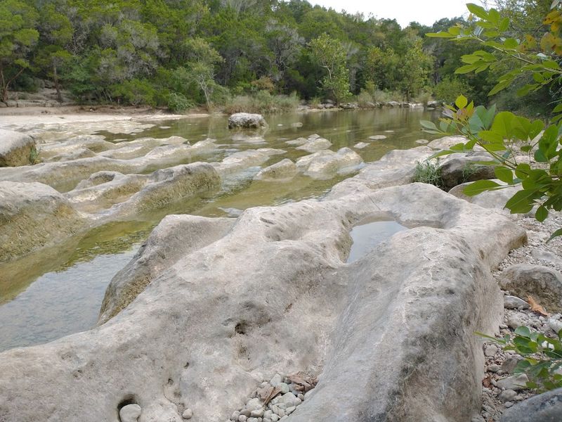
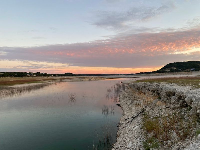
Just a short drive from Jacob’s Well, Blue Hole Regional Park sits along Cypress Creek in Wimberley, and on a good year it earns every bit of its name.
The water turns a deep, almost impossible shade of blue-green beneath a canopy of ancient bald cypress trees, and locals have been swimming here for generations.
But good years are not guaranteed anymore. Cypress Creek depends heavily on consistent rainfall and spring contributions, and when drought grips the region, the creek shrinks fast.
In recent summers, the park has had to limit or suspend swimming entirely because the water dropped too low to be safe or enjoyable.
The exposed creek bed during dry periods reveals smooth limestone shelves and rounded river stones that look almost sculptural. It is a completely different kind of beautiful, quieter and more contemplative, though clearly not what anyone came hoping to find.
The park itself is well managed, with shaded picnic areas and trails that stay worth exploring even without water. Visiting during a drought year gives a real perspective on how dependent the entire Hill Country ecosystem is on rainfall patterns that have become increasingly unpredictable.
Blue Hole is still worth the trip, but calling ahead to check water conditions is genuinely good advice.
Address: 333 Blue Hole Ln, Wimberley, Texas
2. Jacob’s Well
There is something quietly heartbreaking about arriving at Jacob’s Well and finding it still. Most people know this spot as one of Texas’s most iconic natural springs, a circular opening in the earth that once pushed up a steady, mesmerizing column of crystal-clear water from deep underground aquifers.
During dry years, that upward flow slows to almost nothing. The swimming area has been closed repeatedly due to dangerously low water levels, leaving behind a limestone rim that looks more like a forgotten well than a living spring.
The Trinity Aquifer, which feeds Jacob’s Well, struggles to recharge fast enough when rainfall stays scarce for months at a time. Nearby development and population growth in the Wimberley area have added pressure to an already strained system.
What makes this place worth visiting even now is the raw geological beauty of it. The exposed limestone shelf tells a story of ancient water movement that no drought can erase.
Rangers and conservationists are working hard to protect what remains, limiting visitor numbers and monitoring flow rates closely. Seeing Jacob’s Well in a low-water state is a sobering reminder of how fragile even the most legendary springs can be.
Address: 1699 Mount Sharp Road, Wimberley, Texas
3. Las Moras Springs
Out near Brackettville in Kinney County, Las Moras Springs once produced a reliable flow of cool, clear water that fed the Las Moras Creek and supported an entire community of plants, animals, and people going back centuries.
The springs were historically significant enough that Fort Clark was built beside them in 1852, relying on their output as a primary water source.
Today, the story is much harder to tell with optimism. The springs have experienced dramatic reductions in flow, and there are stretches when they run completely dry.
Groundwater pumping in the surrounding region has drawn down the aquifer that once kept this system alive, and the effects are visible in the landscape.
Where there was once a lush riparian corridor with cottonwoods and willows trailing their branches into moving water, there are now dry channels and stressed vegetation.
The ecological damage extends well beyond the visual, as native fish species that depended on these springs have faced serious population pressures.
Las Moras is not a well-known tourist destination, and that relative obscurity makes its decline feel even more sobering. It is the kind of place that disappears quietly, without headlines, even as it loses something irreplaceable.
The springs represent a broader pattern playing out across the Edwards Plateau region of Texas.
4. Barton Creek Greenbelt
Austinites have a deep, almost personal attachment to the Barton Creek Greenbelt.
It is their backyard wilderness, a stretch of trails and swimming holes that cuts right through the city, and on a hot summer afternoon with water running high, spots like Twin Falls, Sculpture Falls, and Campbell’s Hole feel genuinely magical.
The problem is that high water is no longer something you can count on. During drought years, Barton Creek slows to a trickle and sometimes stops moving entirely in its upper reaches.
The swimming holes become disconnected pools, and even those shrink under the relentless Texas sun.
Sculpture Falls, which normally cascades over a wide limestone shelf in a way that makes you want to just sit and stare at it, can look like an empty stage during dry spells.
The rock formations remain stunning, but there is an eerie quality to standing on them without the sound of moving water underneath your feet.
Twin Falls and Campbell’s Hole face similar seasonal uncertainty. The greenbelt itself stays open and hikeable year-round, and the trails through cedar and oak woodland are genuinely lovely.
But the water is the heart of this place, and when it retreats, the whole atmosphere shifts. Checking the Barton Springs flow data before visiting is something every smart visitor learns to do.
Address: 3755 South Capital of Texas Highway, Austin, Texas
5. Paluxy River at Dinosaur Valley State Park
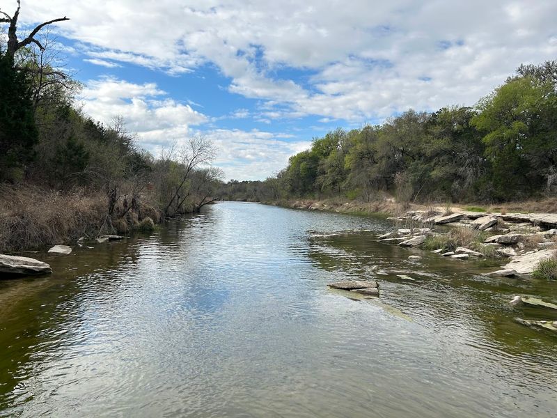
The Paluxy River runs through Dinosaur Valley State Park near Glen Rose, and under normal conditions it is a shallow, pleasant stream where you can wade and watch the water move over ancient limestone.
Beneath that limestone are some of the best-preserved dinosaur tracks in the world, left behind roughly 113 million years ago.
When the river dries up, which it has done dramatically during recent droughts, those tracks become fully exposed. In 2022, an extended dry period revealed an enormous set of prints believed to belong to Sauroposeidon, a massive long-necked dinosaur that would have dwarfed anything alive today.
The sight was genuinely extraordinary.
But the riverbed exposure is not just a paleontology highlight. It is also a signal that something is wrong.
The Paluxy depends on rainfall and spring contributions to keep flowing, and when those dry up, the creek becomes a pale shadow of itself. The surrounding ecosystem, including the river’s fish and aquatic insects, takes a serious hit.
Visiting the park during a low-water period offers a surreal experience, almost like time travel. The dinosaur tracks sit there in the open, undeniable and massive, while the empty riverbed stretches around them.
It is one of the strangest and most memorable things you can see in Texas.
Address: Glen Rose, Texas
6. Rio Grande
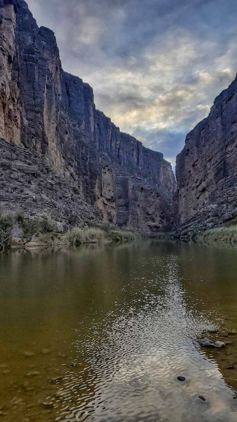
The Rio Grande carries a name that promises something grand, a great river forming the entire southern border of Texas, cutting through canyons and desert landscapes that take your breath away. The reality in recent decades has been a lot more complicated and a lot more troubling.
Sections of the Rio Grande in West Texas, particularly near Big Bend, have seen dramatic reductions in flow. There are stretches where the river has essentially stopped, leaving behind sandbars and dry channels where water once ran deep enough for rafting.
The causes are layered: upstream diversions in Colorado and New Mexico, groundwater depletion, and prolonged drought have all played a role.
Big Bend’s Santa Elena Canyon, one of the most photographed river corridors in the state, has had seasons where its iconic reflections were replaced by cracked mud and exposed rock. The contrast between what the canyon looks like in wet years versus dry ones is genuinely shocking.
The river’s decline affects far more than recreation. Border communities, wildlife, and entire agricultural systems depend on its flow.
Migratory birds that rely on riparian habitat along the Rio Grande are losing nesting and feeding grounds. Visiting Big Bend and seeing the river at low ebb is not discouraging so much as clarifying.
It makes the stakes of water conservation feel immediate and real.
7. Lake Abilene
Lake Abilene sits inside Abilene State Park and has been a recreational anchor for West Texas families for decades. Fishing, kayaking, and lakeside camping all revolve around its water levels, and when those levels drop, the whole character of the park shifts noticeably.
Drought years have not been kind to this reservoir. The lake has experienced significant drawdowns, exposing wide stretches of red clay lakebed that crack in the heat and stretch toward the water’s edge like a slow retreat.
The sight of boat ramps ending in dry land is one of the more common images associated with Texas drought coverage.
What is interesting about visiting during a low period is how the park itself adapts. The trails, cedar breaks, and wildlife habitat remain intact, and the buffalo herd that roams nearby does not seem particularly bothered.
Birding around the park is consistently rewarding regardless of water levels, since the surrounding woodland supports a wide variety of species.
But the lake is the centerpiece, and without it, the energy changes. The park staff does a good job of maintaining facilities and keeping the campgrounds welcoming, but there is no substitute for actually having water in a reservoir.
Lake Abilene’s story is one being repeated at smaller reservoirs across West and Central Texas as rainfall patterns shift.
Address: 150 Park Road 32, Tuscola, Texas
8. Medina Lake
Medina Lake has one of the most dramatic drought stories of any reservoir in Texas. During the severe drought years of the early 2010s, the lake dropped to single-digit capacity, and things that had been underwater for decades started emerging from the mud.
Old structures, fence posts, and submerged tree stumps appeared along the exposed shoreline like artifacts from another time.
The lake sits in the Hill Country southwest of San Antonio and was formed by Medina Dam, completed in 1913, making it one of the oldest reservoirs in the state. Its age means the landscape around it carries layers of history, and when water retreats, some of that history becomes briefly visible.
Recovery has been uneven. Wet years bring the lake back toward fuller levels, but the swings between high and low have become more extreme and less predictable.
Property owners around the lake have watched their waterfront access come and go with the seasons and the rainfall totals.
For travelers curious about the visual impact of drought on Texas water bodies, Medina Lake during a dry cycle is genuinely striking. The pale limestone cliffs and cedar-covered hills surrounding the basin look almost Mediterranean when the water is high.
When it is low, the exposed margins tell a starker story about the limits of water storage in a warming climate.
Address: 1605 PR 37, Lakehills, Texas
9. Lake Buchanan and Old Bluffton

Lake Buchanan is the largest of the Highland Lakes chain on the Colorado River, and it holds a secret beneath its surface that only shows itself during serious droughts. The town of Bluffton, flooded when the lake was created in 1937, sits submerged under normal conditions.
When water levels fall far enough, its remnants emerge from the lake floor like a ghost town returning from the past.
Old foundations, rock walls, and the outlines of former streets have all appeared during significant drawdowns, drawing visitors from across the state who come specifically to walk through what was once a living community. It is eerie and fascinating in equal measure.
The lake itself serves as a critical water supply for the Austin metro area, so low levels carry consequences well beyond the atmospheric. When Buchanan drops, the entire Highland Lakes system feels the pressure, and water managers face difficult decisions about allocation and conservation.
The surrounding landscape, rolling cedar hills and granite outcrops near Llano County, is genuinely beautiful even when the lake is low. Vanishing Point, the rocky peninsula that extends into the lake, becomes much more dramatic when water recedes around it.
Visiting Old Bluffton during a drought cycle is one of those rare Texas experiences that manages to be both historically moving and environmentally sobering at the same time.
Address: Buchanan Dam Texas
10. Hamilton Pool Preserve
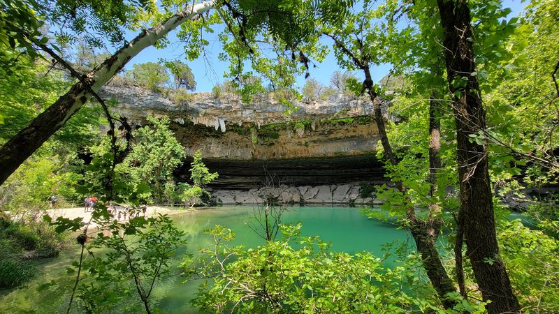
Hamilton Pool Preserve is the kind of place that looks like it belongs in a fantasy novel. A collapsed grotto forms a natural amphitheater, with a waterfall dropping from the limestone overhang into a jade-green pool below, all of it framed by hanging ferns and the sound of water echoing off rock.
On a good day, it is one of the most visually stunning spots in Texas.
Drought changes that picture considerably. The waterfall that feeds the pool depends on Hamilton Creek, which in turn depends on rainfall in the Pedernales watershed.
When the watershed goes dry, the waterfall slows to a drip and the pool drops, sometimes to the point where swimming is prohibited entirely.
Travis County Parks manages the preserve carefully, requiring reservations and limiting daily visitors to protect the fragile ecosystem. Even when water levels are low, the geology of the place remains extraordinary.
The layered limestone ceiling of the grotto, streaked with mineral deposits and draped in maidenhair fern, is worth the drive on its own.
The creek trail leading down to the pool passes through cedar and oak woodland that smells incredible after any rain. During dry spells, the creek bed along that trail becomes a series of disconnected puddles.
Hamilton Pool during drought is still beautiful, just in a quieter, more melancholy way that makes you appreciate the full version even more.
Address: 24300 Hamilton Pool Road, Dripping Springs, Texas
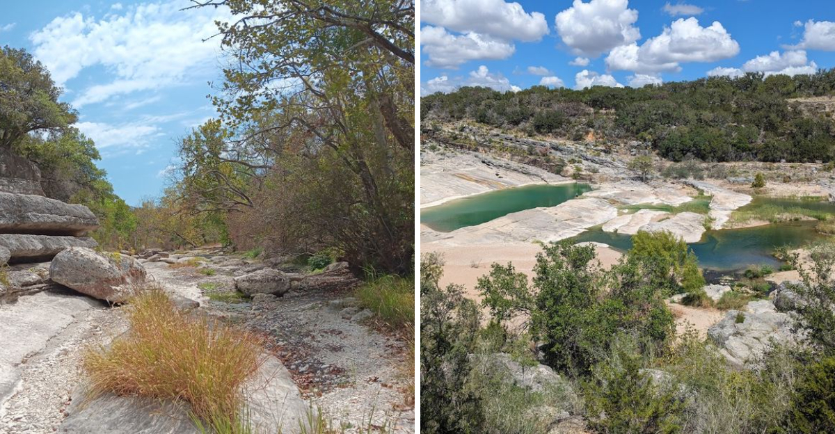
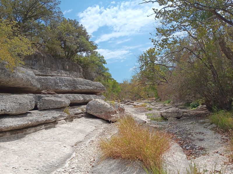
11. Pedernales Falls
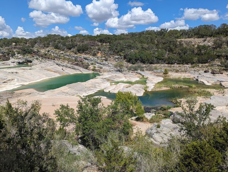
Pedernales Falls State Park near Johnson City contains one of the most distinctive geological features in the Texas Hill Country.
The Pedernales River crosses a wide, steeply tilted limestone shelf in a series of steps and channels that, when flowing, create a rushing, photogenic cascade that stretches across the entire valley floor.
When the river drops during drought, those same limestone formations sit completely exposed under the open sky, and the effect is almost surreal. The rock surface is layered and tilted at dramatic angles, and without water moving across it, you can really appreciate the scale and complexity of the geology.
It is a completely different experience from a wet visit, not better or worse, just different.
The park trails remain excellent year-round, with the Wolf Mountain Trail offering elevated views across the river valley that are honestly more impressive when the water is low and the full extent of the exposed limestone is visible. Wildlife is reliably present throughout the park regardless of river conditions.
I found myself lingering longer than expected on a dry visit, partly because the silence was so complete. No rushing water, no crowd sounds, just wind moving through the live oaks and the occasional hawk circling overhead.
Pedernales Falls in drought is a study in geological patience, a reminder that the rock was here long before the water and will be here long after it returns.
Address: 2585 Park Road 6026, Johnson City, Texas
Dear Reader: This page may contain affiliate links which may earn a commission if you click through and make a purchase. Our independent journalism is not influenced by any advertiser or commercial initiative unless it is clearly marked as sponsored content. As travel products change, please be sure to reconfirm all details and stay up to date with current events to ensure a safe and successful trip.