A surveying mistake a hundred years ago saved these trees from being logged like the rest. I walked into a forest where the pines stretch so high that looking up gives you a dizzy neck.
Minnesota has a hidden grove that feels ancient and secret because it almost disappeared completely. The two mile trail is gentle enough for a lazy afternoon stroll through towering green giants.
Some of these trees were already alive when your great grandparents were young children exploring their own worlds. I ran my hand over bark that has seen more seasons than any human could ever count.
The light filters down through the canopy in golden patches that move slowly with the breeze. Minnesota really preserved a piece of history by accident and now we get to wander through it.
Families walk quietly here because loud voices feel wrong among such old and peaceful company. You leave feeling small in the best way like the forest gave you a gentle hug.
The Fascinating History Behind the Name

Most trails do not come with a backstory this good. Back in 1882, government surveyors were mapping sections of northern Minnesota for logging.
They made a mistake, marking a stretch of land as part of a nearby lake. Because of that error, logging companies never touched it.
The trees were left completely alone. Decades passed.
The forest kept growing. By the time anyone realized the land was actually dry ground covered in ancient pines, it was already too late to log it, and honestly, that is a very good thing.
Lost 40 gets its name from that surveying blunder. The “forty” refers to the forty-acre land parcels used in old government surveys.
Signs along the trail explain the full story in clear, easy-to-read language. Reading them while standing under hundred-foot pines makes the whole history feel very real.
It is the kind of place that reminds you how one small mistake can accidentally create something worth protecting forever.
Ancient Red and White Pines You Will Not Forget

Standing at the base of one of these pines and craning your neck back is a moment you remember for a long time. The red pines here are massive.
Their trunks are wider than most people can wrap their arms around, and their bark has that deep reddish-brown color that makes them look like something out of a painting.
White pines grow here too. They tend to be even taller, with smoother bark and longer needles.
Both species survived because no logging crew ever came through. That means these trees have been quietly growing for well over 150 years.
The sheer variation in trunk size is striking. Younger trees grow in the understory, but the giants dominate the canopy.
You can feel the age of the place just by looking up. Most forests in Minnesota were logged at least once.
Lost 40 never was. That makes every single tree here a living piece of history worth slowing down to appreciate.
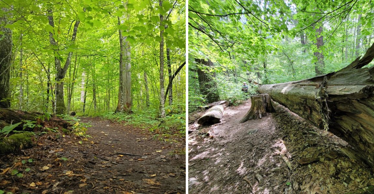
The Two-Mile Loop Trail and What to Expect

The main loop at Lost 40 runs about two miles. For most people, that takes somewhere between 30 minutes and an hour, depending on how often you stop to look up at the trees.
The trail is well-marked and relatively easy to follow.
Flat it is not, though. Lost 40 sits on an esker, which is a ridge of land left behind by a retreating glacier.
That means you will go up and down some surprisingly steep hills along the way. The elevation changes are short but sharp.
Roots cross the path in spots, and the surface stays natural throughout. Sturdy shoes are a smart call.
The trail is maintained by the U.S. Forest Service and is generally in good shape.
Informational signs are posted at several points, sharing details about the trees, the geology, and the history of the forest. Plan to read them.
They genuinely add something to the walk and make the experience feel more complete.
The Esker: Walking on a Glacial Ridge

Not many hiking trails take you across a glacial landform, but Lost 40 does. The forest sits on an esker, a long winding ridge created when a river flowed under a glacier thousands of years ago.
When the ice melted, the riverbed stayed behind as a raised ridge of sand and gravel.
Walking the trail, you can feel the ground rising and falling beneath your feet. The hills come at you suddenly.
One moment you are on flat ground, and then the path pitches upward at a solid angle. It keeps the walk interesting and a little bit athletic.
The esker also explains why this particular patch of forest looks and feels different from the surrounding landscape. The elevated, well-drained soil creates conditions that suit old pines perfectly.
Standing on that ancient ridge, surrounded by trees that have been growing since before your grandparents were born, gives the whole hike a layered feeling. You are walking through both geological time and human history at the same time.
Wildlife and Biodiversity Along the Path

Old-growth forests support life in ways younger forests simply cannot. Lost 40 is home to a remarkable range of species.
Birch and spruce trees grow alongside the dominant pines, creating a layered habitat that supports birds, insects, and mammals that depend on mature trees.
Woodpeckers are common here. You can often hear them drumming before you spot them.
Nuthatches and chickadees move through the canopy. The understory is thick in places, giving smaller animals plenty of cover.
Wildflowers appear in spring and early summer.
Bring bug spray. This is genuine northern Minnesota wilderness, and the insects are part of the experience.
June visits especially can mean heavy mosquito activity. That said, the bugs are a small trade-off for walking through a forest ecosystem that has been developing without interruption for over a century.
The biodiversity here is genuinely different from a managed or replanted forest. You can sense it.
The air smells richer. The sounds layer differently.
Something about old growth just feels alive in a deeper way.
Best Times to Visit Lost 40

Lost 40 is open year-round, but each season brings something different. Summer offers full green canopy and the best chance to see wildlife.
Early June is beautiful, though bug spray becomes essential. Late summer tends to be drier and a bit easier on the insect front.
Fall might be the most spectacular time to visit. The hardwoods, especially the birch trees, turn gold and orange.
That color pops dramatically against the deep green of the pines. The drive out from Blackduck is stunning in late September.
The trail itself stays manageable well into autumn.
Winter visits are possible but require snowshoes or good boots and some navigation confidence since trail markers can be harder to spot under snow. Spring brings wildflowers and fresh growth, though the forest floor can be muddy after snowmelt.
No matter when you go, the trees are always there, massive and quiet and completely unhurried. They have been standing through every kind of Minnesota weather for over a century, and they are not going anywhere soon.
How to Get There and What to Bring

Getting to Lost 40 takes some commitment. The trailhead sits down a gravel road off County Road 29, northeast of Blackduck in Beltrami County.
Cell service gets spotty. Download your directions before leaving town, and do not count on GPS once you are on the back roads.
The parking area is small. A handful of cars fit comfortably, and on busy days it can fill up.
Arriving early in the morning is the smartest move. There is a pit toilet at the trailhead, but no running water and no trash cans.
Pack out whatever you pack in.
Bring water, snacks, and bug spray. Wear layers in spring and fall since temperatures in the forest feel cooler than open areas.
Sturdy closed-toe shoes handle the rooted, hilly terrain better than sandals. Pets are not permitted on the trail.
A small daypack keeps everything organized. The hike itself is short, but being prepared makes the whole experience more enjoyable.
Reading the Trail Signs: History at Every Turn

One of the unexpected highlights of this trail is the signage. Interpretive signs are placed at key spots along the loop, and they are genuinely worth reading.
Each one covers a different topic, from the surveying error that saved the forest to the ecology of old-growth pines.
The writing on the signs is clear and accessible. You do not need a forestry degree to understand them.
Some explain how scientists can tell a tree’s age by its girth and bark patterns. Others describe what makes old-growth forests ecologically different from younger managed forests.
I found myself stopping longer at the signs than I expected to. They add real depth to what could otherwise be a simple walk in the woods.
Understanding why the trees look the way they do, and why this specific patch of forest survived, makes every step feel more meaningful. The U.S.
Forest Service has done a thoughtful job of making the history accessible without making it feel like a classroom. It strikes a nice balance between education and atmosphere.
Accessibility and Trail Conditions

Lost 40 is not a paved, groomed trail. The surface is natural, with exposed roots, occasional muddy patches, and those sharp esker hills.
For most able-bodied hikers, the difficulty is light to moderate. The two-mile length keeps it manageable for a wide range of fitness levels.
For visitors using mobility aids, the trail presents real challenges. Roots and steep sections make much of the loop difficult to navigate in a wheelchair.
Some visitors have reported getting a short distance in before needing to turn back. The parking area and the immediate trailhead area are more accessible than the trail itself.
Families with young children generally do well here. Kids seem to love the massive trees and the hills.
Older visitors in good health handle the loop without trouble. The trail is not long enough to be exhausting, but it is uneven enough to require attention underfoot.
Wearing the right shoes genuinely matters.
Why Lost 40 Deserves a Spot on Your Minnesota List

Some places earn their reputation. Lost 40 is one of them.
The trees alone justify the drive. Seeing pines this old and this tall in person is genuinely different from looking at photos.
The scale does not translate through a screen. You have to stand there.
The story behind the forest makes it even better. A simple mapping mistake from over 140 years ago is the only reason this stand of old growth still exists.
That feels significant. It also feels a little fragile, which is probably why visitors tend to speak quietly and walk slowly once they are inside the canopy.
Lost 40 is not a flashy destination. There is no visitor center, no gift shop, and no coffee stand nearby.
It is just a forest, a trail, and trees that have been growing since before anyone alive today was born. That simplicity is the whole point.
If you are in northern Minnesota and you skip this place, you will regret it.
Dear Reader: This page may contain affiliate links which may earn a commission if you click through and make a purchase. Our independent journalism is not influenced by any advertiser or commercial initiative unless it is clearly marked as sponsored content. As travel products change, please be sure to reconfirm all details and stay up to date with current events to ensure a safe and successful trip.